Elbrus divides the surrounding mountains into two very different areas. The Baksan area with its peaks around 4000 m and above is much harsher in terms of climbing conditions compared to the Western Caucasus regions. This is evidenced by:
- large altitude differences,
- heavily broken glaciers,
- mandatory snow at high altitudes.
In contrast, the area west of Elbrus — Uzun-kol — is mostly purely rocky. All peaks in this area (except Gvandra) are below 4000 m. Climbing usually doesn't involve overcoming significant glaciers, and all steep slopes are free of snow and ice.
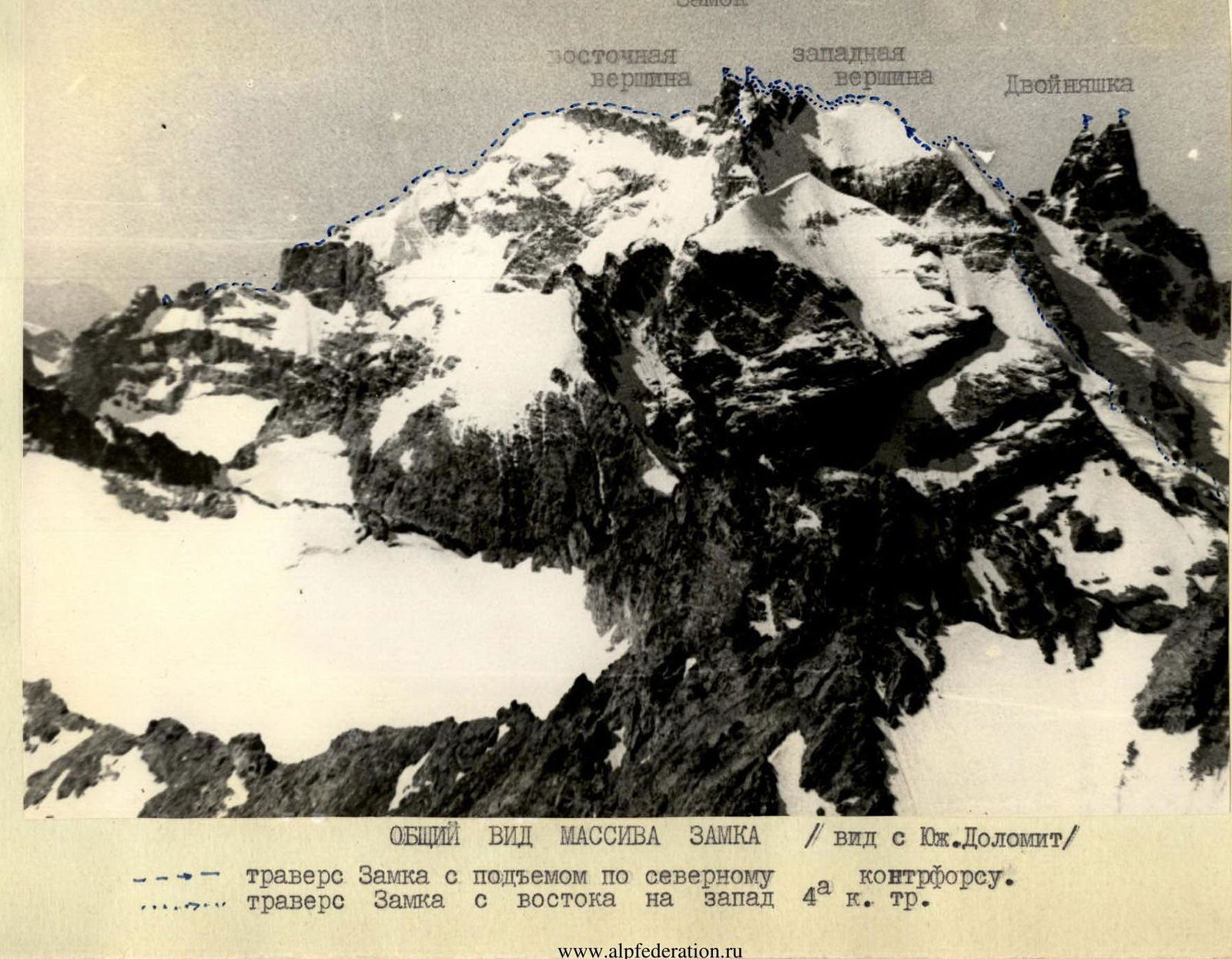
The Zamok peak is located in the Main Caucasus Range. Together with Dalar and Dvoinyashka, it forms the base of a horseshoe that encompasses the upper reaches of the Kichkinekol River, which, merging with Mordy, forms Uzun-kol. In terms of height, Zamok (3930 m) is second only to:
- Gvandra
- Dalar
The two peaks of Zamok — Eastern and Western — are situated on a ridge, the northwestern part of which leads to Dvoinyashka, while the southeastern part stretches in an arc, curving around the Zamok glacier from the south. This southeastern part of the ridge had not been traversed before the ascent described below. To the northeast from the Western peak of Zamok, a ridge leads, steeply descending to the Burvestnik pass, and then slowly rising to the Filter peak. To the south-southwest from the same Western peak, the South Counterforce extends. Significantly west of both Zamok peaks and all its gendarmes, the North Counterforce leads to the Bolshoy Kichkinekol glacier.
The main difficulty in climbing in the Uzun-kol area lies in overcoming complex rock walls of heavily broken rock ridges; however, climbs usually don't take much time. Examples of relatively short but extremely complex routes include the well-known wall routes:
- ascent to v. Kirpich along the inner wall,
- ascents to v. Dalar along the northern wall.
Ordinary climbs differ from the above-mentioned only in less complex rock or significantly shorter complex sections.
The traverse described below is not typical for this area.
The northern slopes of Zamok are steep ice or snow-ice walls with outcrops of steep, often icy rocks. On both sides of the Zamok rock massif — to the southeast and northwest — snow ridges extend, forming elongated shoulders with steep snow slopes.
At the same time, the brokenness of the main rock ridge and steep rock outcrops on the counterforces indicate serious difficulties that should arise during the ascent.
Therefore, if drawing analogies with other mountain regions, it would be more logical to classify ascents on Zamok as belonging to the Bezengi type.
The group that made the traverse of Zamok consisted of five people. Below are the main sports data of the traverse participants.
| № п.п. | Participant's surname | Rank | Climbs beyond rank | 5А | 5Б |
|---|---|---|---|---|---|
| 1. | Kolchin A.A. | MS | 6 | 1 | 7 |
| 2. | Blyakhman K.P. | 1st sports rank | 4 | 2 | – |
| 3. | Abdrashitov R.A. | 1st sports rank | 3 | 1 | – |
| 4. | Stelmakh M.F. | 1st sports rank | 10 | 2 | 1 |
| 5. | Borovikov A.V. | 2nd sports rank | 7 | 1 | – |
In preparation for the traverse, the group members studied the intended route using photos of Zamok provided by the Uzun-kol alpine camp's training department and KSP, and also observed the intended path during ascents to surrounding peaks (Dalar, South Dolomite, Filter). As a result of these ascents, the following order of ascent was planned.
Day one. From the Bolshoy Kichkinekol glacier — bypassing the lower bastion of the North counterforce from the right and exiting onto the counterforce in the area of the snowfield. Climbing to the upper bastion, where an overnight stay was planned.
Day two. Since large crevices and icefalls are clearly visible to the right of the main steep ascent of the counterforce, and an ice wall and a clearly visible chute from falling rocks are visible to the left, it was planned to exit directly onto the rock ridge of the counterforce. Then upwards along the rocks to the main ridge of Zamok, where an overnight stay would be organized.
Day three. The path to the peak in the direction opposite to the path of 4A category of difficulty. Descent onto the southeastern ridge, at the end of which a descent to the right along the grassy-rocky shelves.
Since complex ice work was not expected, it was decided to bring only one pair of crampons and three ice screws. In addition, the usual equipment was taken.
The traverse showed that it was tactically correct. However, several adjustments were made to the route along the way.
The ascent along the North counterforce proceeded as follows.
From the lower Kichkinekol overnight stays, the path goes along the moraine under the North ridge of the Filter peak and further along the Bolshoy Kichkinekol glacier towards the lower rock bastion R1. The bastion was left on the left, bypassing it along the glacier around individual ice walls and crevices in such a way as to exit onto the snowfield R2.
This field was ascended via a rather complex five-meter rock wall; the start of the ascent up the wall is near the beginning of a wide, steeply descending rantkloft. Then follows an ascent directly head-on up the snowfield, staying on its right part (80–100 m, steepness 40°).
Moved to the right edge of the counterforce along simple shelves and along the boundary of snow and rocks reached the upper R3. Under the wall of the bastion along gentle but smooth slabs — traverse left-upwards. It should be noted that there are very few cracks for pitons in this place.
After bypassing the bastion, ascended upwards onto the ridge along complex, heavily snowed and icy rocks. At the site where the overnight stay was supposed to be, the first control cairn R4 was set up.
Since the first section of the route was completed faster than expected (in 6 hours), it was decided to continue the ascent. From the site, it was visible that the previously considered path directly up the steep rock ascent was extremely complex. It became clear that it was most reasonable to look for a simpler bypass path. After observing the ice chute and establishing that rocks and ice were not falling from it, started moving directly upwards along the steep ice slope ( местами до 50° ), a few meters to the left of the chute. The first person went on crampons and hammered in ice screws, the rest ascended using sports climbing techniques. After ascending onto the steep snow ridge, exited onto white quartz rocks, but there were no paths along the bridges to cross the bergschrund. The path to the saddle R7 went along quartz rocks R5: the lower part of the rocks is of medium difficulty, at the top along the couloir R6 very complex rocks. However, it is not possible to go along the couloir due to rockfall danger, severe icing, and the impossibility of organizing either piton belays or belays through ledges.
On the saddle, an overnight stay was organized. A second control cairn was also set up here.
Above the saddle, the counterforce becomes somewhat gentler. The path goes along rocks of medium difficulty 30–50 m to the right of the ridge. Not reaching one rope length to the ice couloir R8 along an internal corner with accretion ice, going upwards to the right, exited onto the ridge. Further along the snow ridge R9, initially steep, and then quickly becoming gentler, ascended onto the main ridge of Zamok.
Further, the path goes along a snow-scree ridge with a series of ascents and descents to a steep rock drop R10:
- Descent along a rope 15 m.
- Then descent into a gap by climbing 30 m.
From the gap, ascent onto the first gendarme R11:
- Initially from an internal corner from under an overhanging wall to the right — upwards (with the help of a ladder) along a repelling rock to a crack going left — upwards.
- Then along this crack 8–10 m to an overhanging wall.
- Under it, traverse to the right onto a platform 6–8 m.
Climbing is extremely difficult, without backpacks, with subsequent pulling up of backpacks.
Further, the path goes along simple rocks upwards: not reaching 40–50 m to the top of the gendarme — descent to the right along an internal corner and further traverse along an inclined shelf to the saddle under the Western peak.
- Bypassed the peak from the right along shelves (40 m);
- Further upwards along the wall (15 m) onto the upper rock shelf, along which traverse 40 m to the right — directly under the Western peak.
From here, ascent head-on up the wall, orienting towards a notch R13 in the ridge before the peak. Climbing is very difficult: the first person went without a backpack.
From the notch to the Western peak of Zamok leads a 6–7-meter wall: it can only be overcome without backpacks. The first person on this section climbed with a boost.
From the Western peak — descent into the gap between the peaks and ascent onto the Eastern peak by simple climbing.
In preparation for the traverse, it was decided to descend onto the southeastern ridge directly from the Eastern peak. However, during the ascent, it became clear that the descent from the Western peak was simpler. Therefore, the group returned to the Western peak, from where, after descending using a rappel on three ropes and crossing the couloir leading down from the saddle between the peaks, exited onto a snow slope and, traversing it, exited onto the southern shoulder of the massif into a wide (5–6 m) rantkloft. Here, an overnight stay was organized.
The further path — along a horizontal snowfield with large snow cornices. The first rock drop R14 was bypassed along a scree shelf to the right. From the second drop, a sports descent was organized. Further along a steep snow ridge R15 and simple rocks exited again onto a wide snow-scree ridge. Before the next descent onto the snow to the left, below the bergschrund R16, — descent along a three-meter rock wall and along the snow descent into the gap of the ridge.
A wide scree ridge leads to a new gap before a large gendarme. Descent into the gap — along rocks of medium difficulty. The gendarme is bypassed from the right. Overcoming head-on and in parts three small ascents, descended into a wide couloir to the right.
After descending along screes and snowfields for approximately 200 m, before the narrowing of the couloir — traversed into the next couloir (30 m of rocks of medium difficulty).
Further — a simple path along scree and grassy shelves bypassing the SE ridge and return to the camp.
Throughout the entire traverse, the composition of the rope teams changed constantly. On the first day, the arrangement was as follows:
- Pair: Kolchin and Blyakhman
- Trio: Abdrashitov, Stelmakh, and Borovikov
In the second half of the day:
- Pair: Kolchin and Abdrashitov
- Trio: Blyakhman, Stelmakh, and Borovikov
The next two days, Kolchin and Borovikov climbed in a pair.
Individual sections of the route were also led by everyone in turn. The most complex sections (see below profile krok) were led by:
- wall section R2 — Blyakhman;
- smooth slabs R4 — Kolchin;
- ice and snow slopes R6 and R7 — Borovikov;
- quartz rocks — Kolchin;
- internal corner with accretion ice — Borovikov;
- wall of the first gendarme — Blyakhman;
- bypass-traverse along the shelf of the second gendarme — Stelmakh;
- wall under the Western peak R17 — Kolchin;
- wall — exit onto the Western peak R18 — Borovikov, etc.
All participants worked equally and showed good preparation.
Thus, the traverse made by the LGS DSO "Spartak" group includes two sections that were traversed for the first time: the ascent along the North counterforce to the main ridge and the descent along the southeastern ridge; the third section, which is part of the traverse route of the Zamok massif from east to west, was traversed in the reverse direction and turned out to be significantly more complex than in the direct direction due to the need to climb walls, from which in the "direct traverse" of 4A category of difficulty a rappel descent is organized.
After the ascent, the traverse participants compared this route to previous climbs they had made and came to the conclusion that the section of the traverse from the start of the ascent to the Eastern peak is undoubtedly more complex than the following routes:
- Dombay 5A category of difficulty
- Songuti 5A category of difficulty
- Amanauz 5A category of difficulty
- Ullu-tau-chana 5A category of difficulty
- p. Tikhonov — Koshtan-tau 5A category of difficulty
- Dvoinyashka 5A category of difficulty
Based on this, the group believes that the traverse of Zamok deserves classification as 5A category of difficulty.
Profile krok and time breakdown
| Section № | Average steep Mayness | Length | Terrain Character | Technical Difficulty | Belay | Weather Conditions | Hiking Hours | Number of Pitons | Category of Difficulty |
|---|---|---|---|---|---|---|---|---|---|
| 11 August 1964 | |||||||||
| R1 | 5–30° | 300 m | glacier | simple | simultaneous | Clear | 40 min | – | 2 |
| R2 | 60° | 40 m | rocks | complex | hand/ledges | " | 15 min | – | 4 |
| R3 | 40° | 80–100 m | snow | simple | hand/ice axe | " | 20 min | – | 2 |
| R4 | 30° | 120 m | rocks | complex | piton belay | " | 1 h | 4 | 4 |
| R5 | 20° | 100 m | rocks | medium complexity | hand/ledges | " | 30 min | – | 4 |
| R6 | 30–50° | 120 m | ice | complex | piton belay | " | 1 h 30 min | 5 | 4 |
| R7 | 30° | 150 m | snow | medium complexity | hand/ice axe | " | 1 h | – | 4 |
| R8 | 30–70° | 200 m | rocks | complex | piton belay | " | 3 h | 9 | 4 |
| 12 August 1964 | |||||||||
| R9 | 15° | 300 m | rocks | medium complexity | piton belay | " | 1 h | 4 | 4 |
| R10 | 30° | 40 m | rocks | medium complexity | piton belay | " | 20 min | 2 | 4 |
| R11 | 30° | 200 m | snow | simple | simultaneous | " | 40 min | – | 2 |
| R12 | 5–20° | 300 m | snow | simple | simultaneous | " | 40 min | – | 2 |
| R13 | 60–90° | 25 m | rocks | very complex | pitons | " | 2 h 30 min | 6 | 5 |
| R14 | 0° | 100 m | rocks | medium complexity | piton belay | " | 20 min | 3 | 4 |
| R15 | 15° | 30 m | rocks | simple | piton belay | " | 15 min | 1 | 3 |
| R16 | 0–40° | 80 m | rocks | medium complexity | piton belay | " | 20 min | 2 | 4 |
| R17 | 50° | 50 m | rocks | complex | piton belay | " | 40 min | 3 | 4 |
| R18 | 70° | 7 m | rocks | very complex | piton belay | " | 30 min | 2 | 5 |
| R19 | 0° | 150 m | rocks | simple | hand/ledges | " | 20 min | – | 3 |
| R20 | –35° | 150 m | rocks | rappel | piton belay | " | 45 min | 3 | 4 |
| R21 | 5° | 80 m | snow | simple | simultaneous | wind | 10 min | – | 2 |
| 13 August 1964 | |||||||||
| R22 | 6–10° | 250 m | snow | simple | simultaneous | thunderstorm | 30 min | – | 2 |
| R23 | –25° | 100 m | snow | simple | hand/ice axe | fog | 30 min | 4 | 2 |
| R24 | 30° | 100 m | rocks | simple | hand/ledges | " | 30 min | – | 3 |
Zamok

General view of the Zamok massif (view from South Dolomite)
- Traverse of Zamok with ascent along the North counterforce.
- Traverse of Zamok from east to west 4A category of difficulty.
North counterforce (view from Burvestnik pass)
- Ascent path.
- Control cairns.
 Group leader _______ Kolchin A.A.