Ascent Passport
- Ascent category — rock climbing
- Ascent area — West Caucasus, Gvandra region
- Peak, route
- Severný Dolomit — 3710 m via the center of the west wall bastion, approximately 5B category of difficulty — first ascent.
- Route characteristics:
- Elevation gain — 650 m.
- Route length — 689 m.
- Length of 5–6 category of difficulty sections — 424 m, including 270 m on the bastion itself.
- Average steepness of the route — 70°, bastion — 82°.
- Pitons hammered:
- Rock pitons — 58, including 7 for ITO
- Chocks — 69, including 20 for ITO
- Number of climbing days — two and a half
- Number of climbing hours — 23 hours.
- Number of bivouacs and their characteristics — one, hanging.
- Team name — team of instructors from "Udzunkol" alpine camp
- Full name of the leader, participants, and their qualification:
| Full Name | Qualification |
|---|---|
| Rybakov | M. I. — leader, CMS |
| Oshe | E. A. — participant, MS |
| Borzov | P. V. — participant, MS |
| Grachev | A. B. — participant, IMS |
- Team coach — Master of Sports of the USSR Zakharov P. P.
- Date of departure and return — 26–28 August 1980.
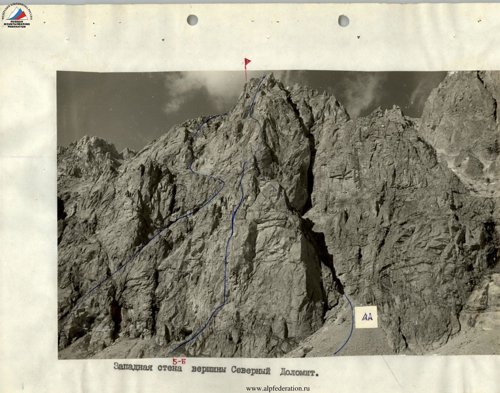 West wall of Severný Dolomit peak. 5B.
 Route of ascent via the center of the west wall bastion of Severný Dolomit, made by the team from "Udzunkol" alpine camp
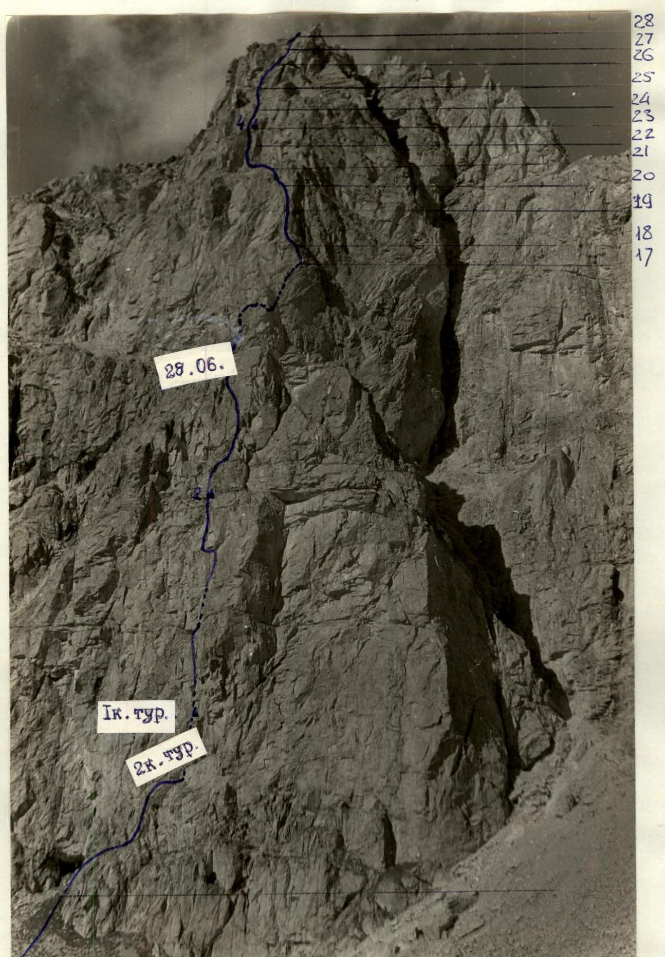
Bastion of the west wall of Severný Dolomit
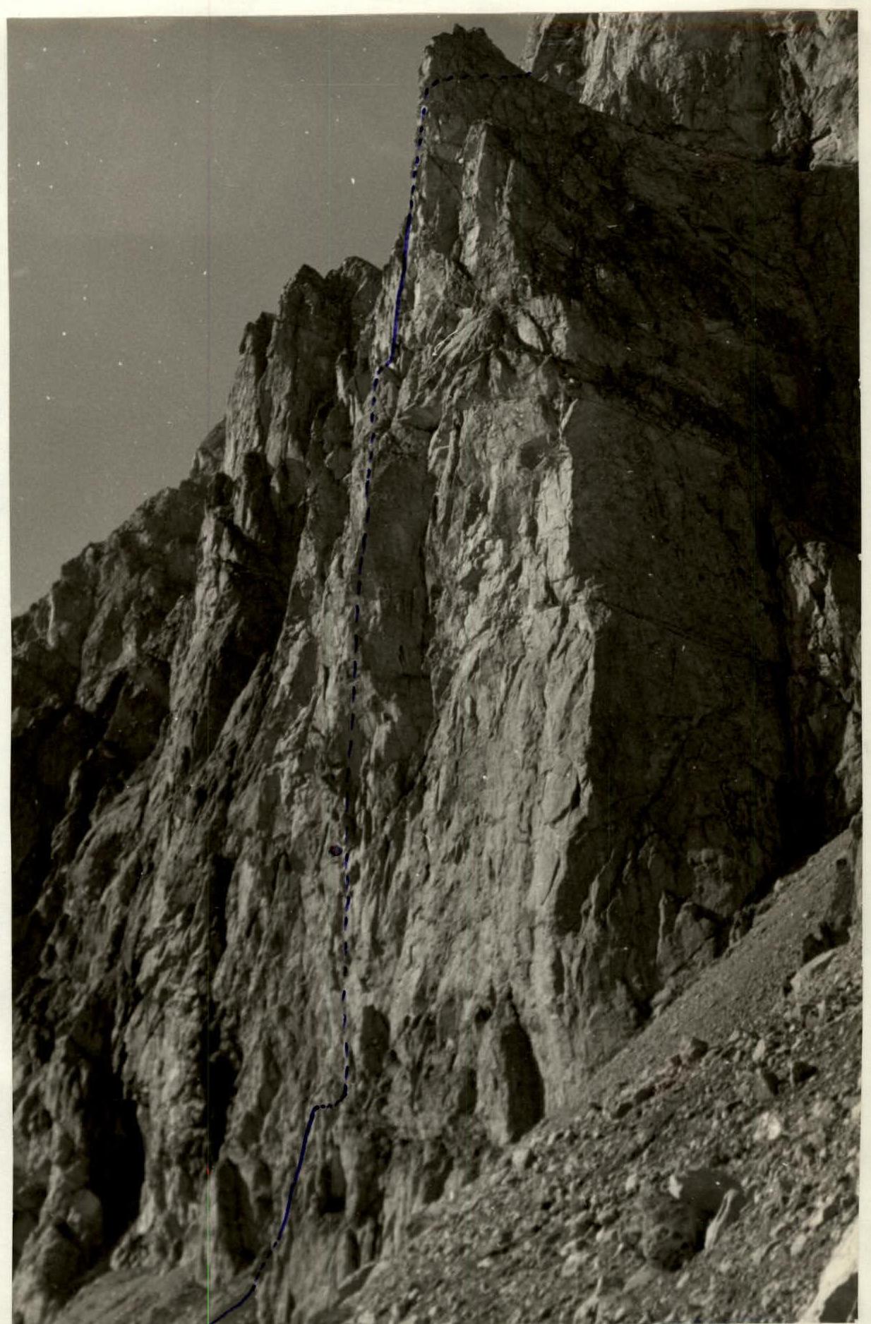
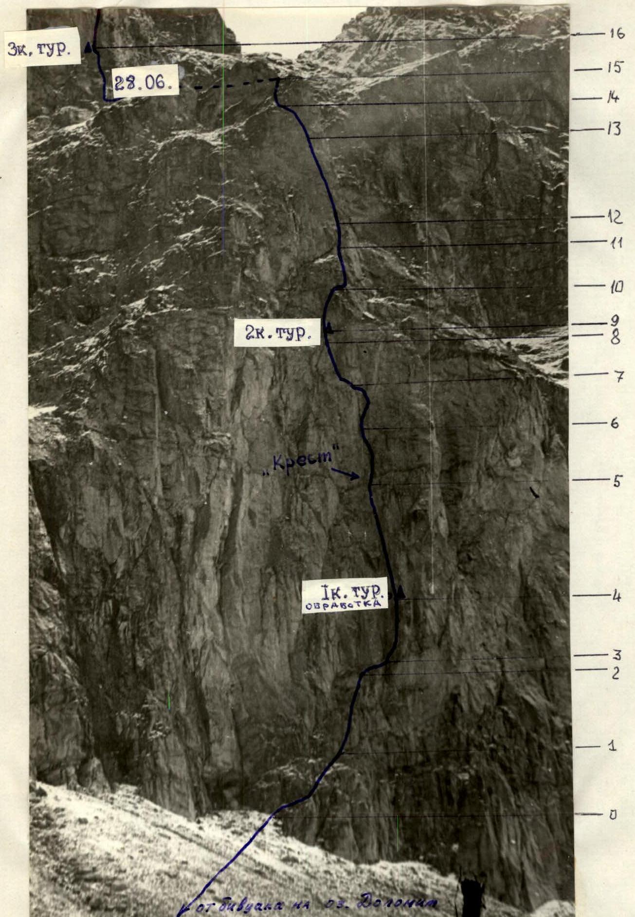 Lower bastion of the West wall of Severný Dolomit peak.
 Map-scheme of the ascent route to Severný Dolomit peak via the center of the west wall bastion — 5B category of difficulty.
20 m ridge to Severný Dolomit
Map-scheme of the ascent route to Severný Dolomit peak via the center of the west wall bastion — 5B category of difficulty.
20 m ridge to Severný Dolomit
Table of main route characteristics
| Designation | Average steepness | Length, m | Character of terrain | Difficulty | Condition | Weather | Rock pitons | Ice pitons | Bolt pitons | Chocks |
|---|---|---|---|---|---|---|---|---|---|---|
| R0–R1 | 75° | 40 | narrow inclined ledges | 2 | monolith | fine | 2 | 3 | ||
| R1–R2 | 80° | 30 | wall | 4–5 | monolith | 2 | 3 | |||
| R2–R3 | 90° | 15 | overhanging rocks, traverse | 5+, A1 | monolith | 2 | 3 | |||
| R3–R4 | 85° | 25 | wall | 5+, 6, A1 | monolith, partially destroyed | 2–2 | 3 | |||
| R4–R5 | 85° | 40 | inner corner, crack on | 5, 6, A3, A4 | monolith | 4–1 | 6 | |||
| R5–R6 | 90° | 22 | crack | 6, A3, A4 | monolith with jammed stones | 3–1 | 4 | |||
| R6–R7 | 90° | 20 | crack, wall | 5+, A3 | monolith | 2 | 3 | |||
| R7–R8 | 75° | 15 | slab-like wall | 5+, A1 | monolith | 1–1 | 1 | |||
| R8–R9 | 100° | 6 | cornice | 7+, A3 | destroyed | 2 | 4 | |||
| R9–R10 | 80° | 15 | inner corner, overhang at bottom | 5+, A1 | partially destroyed | 3–2 | 3 | |||
| R10–R11 | 80° | 25 | ledge, wall | 5+ | destroyed | 3 | 2 | |||
| R11–R12 | 95° | 6 | inner corner with jammed stone | 6+, A4 | partially destroyed | 2 | 3 | |||
| R12–R13 | 85° | 34 | wide inner corner | 5, A2 | monolith | 2 | 6 | |||
| R13–R14 | 80° | 15 | wall | 5 | partially destroyed | 2 | 2 | |||
| R14–R15 | 60° | 30 | inclined rocks | 3 | destroyed | 1 | 2 | |||
| 26 August. Processing the lower part of the bastion: departure at 14:00, return to bivouac — 18:00. | ||||||||||
| R15–R16 | 80° | 40 | wall | 4 | monolith | 3 | 3 | |||
| R16–R17 | 90° | 22 | chimney | 5+ | monolith | 3 | 2 | |||
| R17–R18 | 92° | 7 | wall | 5+ | monolith | 1 | 3 | |||
| R18–R19 | 80° | 40 | wall | 5 | monolith | 3 | 2 | |||
| R19–R20 | 85° | 17 | inner corner | 4 | partially destroyed | 2 | 1 | |||
| R20–R21 | 75° | 20 | large ledge, inner corner | 4–5 | " | 2 | 2 | |||
| R21–R22 | 75° | 25 | inner corner, wall | 4–5 | " | 1 | 3 | |||
| R22–R23 | 75° | 40 | inner corner | 5 | " | 3 | ||||
| R23–R24 | 45° | 30 | slabs | 4+ | " | 1 | 2 | |||
| R24–R25 | 45° | 30 | ledges | 3 | " | 2 | 2 | |||
| R25–R26 | 55° | 30 | inner corner | –4 | " | 2 | 1 | |||
| R26–R27 | 55° | 20 | wall | 4 | " | 2 | 1 | |||
| R27–R28 | 50° | 30 | ledges, walls | 3 | " | 1 | 1 | |||
| 27 August. Departure at 0:00, stop at bivouac at 19:00. Overnight stay. | ||||||||||
| 28 August. Departure at 6:30 am. | ||||||||||
| 28 August — along the ridge 400 m to the summit of the rock 2–3 category of difficulty. At the summit at 13:30. |
Brief explanation for the characteristics table
The landmark for choosing the route is the characteristic cross of a vertical system of cracks and fissures with a horizontal crack crossing the bastion below the middle of the wall. The approach to the route from Dolomit lake takes 20 minutes.
- From left to right along a narrow grassy ledge, under steep overhanging rocks and a 40 m wall. The rocks are monolithic, there are practically no cracks. Up the wall to the right for 30 m to a smooth slab under overhanging rocks. It is very difficult to organize protection. At the top under the overhang there is a large chip, behind which a rope can be fixed and protection organized. Traverse under the overhanging rocks to the right around the corner (very difficult passage!) and along a narrow ledge under the base of the rusty inner corner (3).
Further:
- Up the corner, moving to the right onto the wall and up the wall, using two cracks, to a small ledge. To the right behind the corner in the crack under a stone there is a can with a note (1st control point). To the left of the ledge up 40 m along the inner corner turning into fissures at the top. Slightly up to the right for 20 m, crossing the "Cross" along fissures with sharp edges. Move to the right onto the wall, up and traverse under the yellow cornice to the left (section R6–R7). Up the smooth slab-like wall for 15 m under a destroyed cornice, which is passed on chocks and ladders. There are no good cracks in the cornice. After the cornice there is a narrow ledge. There is a place for a sitting bivouac for four people. Slightly to the right of the base of the characteristic inner corner with an overhang in the lower part — in the crack under a stone is the 2nd control point. Up the inner corner, to the right onto a ledge and along destroyed rocks onto a slab with live rocks (section R9–R11).
Up through a huge yellow stone, jammed in the chimney (difficult, dangerous place!) into a monolithic inner corner and up it to the end onto a wall, along the wall to the left — up into characteristic rock "gate" which leads out onto gentle rocks. 15 m from the summit of the lower bastion.
Exit onto a large ledge crossing the massif of Severný Dolomit peak. Straight up from the ledge along the route is 4A category of difficulty.


