37
WESTERN DVONYASHKA
via the Western wall with an exit to the shoulder along the Northern wall
July 19-26, 1965
Introduction
I. Brief Geographical Description and Sporting Characteristics
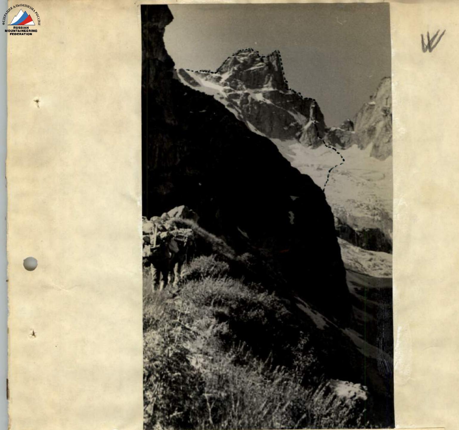
The Dvoynyashka massif (3900 m) rises as a separate double-peaked tower in the chain of peaks along the Main Caucasian Range: Kirpich–Dallar–Dvoynyashka–Zamok. The northern slopes of the massif, which are steeply sloping walls with an average steepness of 70–80°, feed the large Kichkinokol glacier, from which the Uzunkol river originates. The southern slopes are also steep and more eroded.
The massif is composed of dense, hard fine-grained granite and gneiss. The snow line in this area lies at an altitude of 2500 m.
Several routes have been laid on the neighboring peaks Dallar and Zamok:
- from 3B category of difficulty
- to 5B category of difficulty
And until recently, the traverse of Dvoynyashka with ascent to the Western peak from Dallar, 75 m, was practically the only route on this beautiful peak. Later, the traverse of Eastern and Western Dvoynyashka was made in the opposite direction, but the Northwest walls remained unclimbed. Conquering the Northwest walls required:
- new climbing techniques and tactics;
- the use of new equipment.
II. Information about the Climbing Group
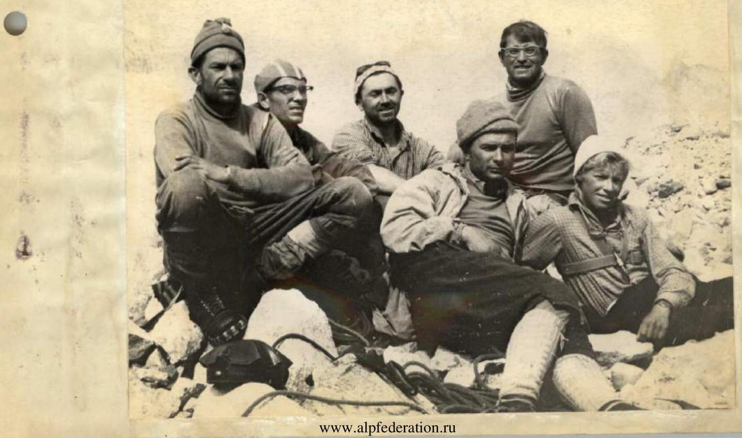
The group of the Ukrainian Council of the Spartak Sports Society, led by Nikolay Koshel (1st sports category), consisting of:
- masters of sports Viktor Yakovina, Gennady Polevoy, Vladimir Kononenko, and Alla Klokova;
- 1st sports category Oleg Polyakovsky, set out on the ascent on July 19, 1965, from the Uzunkol alpine camp.
This ascent was preceded by extensive preparatory work. In the pre-season period, the group members conducted regular joint training sessions. Polyakovsky and Koshel trained according to individual plans.
In the spring, all participants repeatedly visited rock climbing sites for training. On July 1, they gathered at the Uzunkol alpine camp for a training camp. Objective data on the climbing group are provided in Table 1. The participants had sufficient experience in wall climbing of 5B category of difficulty. Their achievements included ascents:
- Peak Free Spain, 5B category of difficulty
- Main Askaut, 5B category of difficulty
- Peak Purovsky (via the bastion), 5B category of difficulty
- Peak Purovsky (via the "surk"), 5B category of difficulty
- Togh-Bashi, 5B category of difficulty
- Chastyn-Tau via the Northwest wall, 5B category of difficulty
- Namison-Khokh via the Northern wall, 5A category of difficulty
- D. Uzhba via the East-West wall, 5B+ category of difficulty
- Dykh-Tau from the south, 5B category of difficulty
- Peak Engels, 5B+ category of difficulty
- Dombay-Ulgen via the Northern wall, 5B+ category of difficulty
To familiarize themselves with the objective, the group members made ascents to the peaks Kirpich, Filter, and Dallar. After observing the wall, they finally chose a route and made an ascent plan. After considering all possible options for ascending to the Western peak of Dvoynyashka from the north, the group chose a route up the Northwest wall (via the "gentle ridge") as the safest and most logical path.
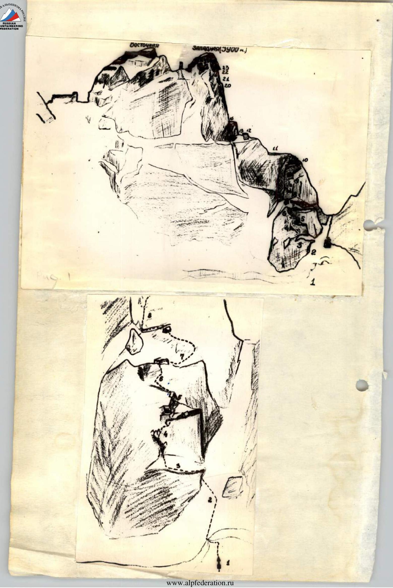
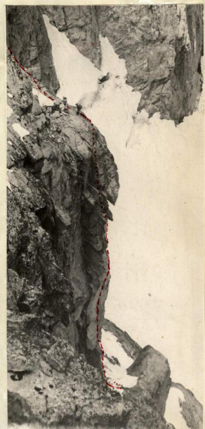
When ascending to the Western peak, it was necessary to reach the shoulder (section R11, Fig. 2), which drops off towards the saddle between Dvoynyashka and Dallar with sheer overhanging walls. Bypassing the shoulder on the left via an oblique snow-ice couloir was very dangerous due to continuous rockfall. Therefore, the group decided to reach the shoulder via the Northern wall, which was protected from rockfall from the couloir.
From the shoulder, the path to the peak was planned via the Western wall, which is visible from the Uzunkol camp in profile as a steep "edge" with an overhanging section at the top (Fig. 2, section R22).
Due to the very unstable weather, the group was equipped with gear (see Table 2) and food (Table 3) that would allow them to wait out bad weather on the route.

During the ascent, the group was under continuous observation. Visual observation of the group's movement until they reached the shoulder was carried out by a group of observers at the lower Kichkinokol campsite.
The section of the Western wall was observed from Dallar by a group led by Bazilevich, who made a traverse of Dvoynyashka from Dallar. Bazilevich's group had radio communication with the camp.
Control communication was maintained with the head of the rescue service of the region, Smirnov, using light signals at agreed-upon times.
The observation group kept a log, which was submitted to the control checkpoint.
III. Route Description and Table of Main Characteristics
July 19. Day 1.
The group set out from the Uzunkol alpine camp at 007:00 AM to the lower Kichkinokol campsite, where observers were stationed. The group moved along the moraine and then along the lower part of the base, heading towards the saddle between Dallar and Dvoynyashka (section R1, Fig. 2).
At 01:00 PM, the first rope team, Koshel and Kononenko, began processing the route through the bergschrund and onto the rocks.
The bergschrund was traversed via a firn plug at the base of the couloir leading to the saddle.
Crossing the couloir diagonally upwards (Fig. 4, section R2), they reached smooth rocks resembling "lamb's foreheads," where a ledge (Fig. 4, section R3) with a snowpatch was found.
The ledge was traversed diagonally upwards to an internal angle with a disrupted crack, where a wedge was hammered. Further movement was:
- upwards-left along complex rocks with good holds;
- towards isolated rock spires;
- then slightly right to a flat rock slab, where there was a spot for a bivouac (Fig. 4, section R4).
The first rope team covered the section R1-R4 in 4 hours, hammering in 12 rock pitons and 2 wedges.
While the first rope team processed the route through snow and rocks, the remaining participants carried backpacks to the internal angle. On section R4, they pulled the backpacks up. Kononenko processed the next section, and the group set up two bivouac platforms: one for sitting on 4 people and one for lying on 2 people; on the left platform, they laid the 1st control cairn.
July 20. Day 2.
The weather was overcast in the morning, with thick fog, wet snow, and graupel. The group started the ascent at 10:00 AM. Along the rope hung the previous evening, they descended without backpacks:
- through the internal angle with sheer walls;
- then along rocks of medium difficulty (60 m, 65°, 5 pitons), reaching a snowpatch (section R6, Fig. 4) at the level of a solitary standing gendarme under the sheer walls leading to the shoulder. Traversing right along the snowpatch for 40 m and then along rocks composed of massive blocks, they reached a small wall (40 m) (section R7, Fig. 4). Here, they set up two good platforms, chopping out an ice anchor. They established a bivouac at 04:00 PM (Fig. 4).
On this section of the route, they worked for 7 hours, hammering in a total of 14 rock pitons and 1 piton.
July 21. Day 3.
The weather was cloudy, as on the previous day, but without precipitation in the morning. At 09:20, a team of three - Yakovina, Kononenko, and Koshel - set out to process the route. Along a narrow ledge (10 m), they reached a protruding outer angle with a vertical crack the width of a palm. The crack led to a platform (1×1.5 m) (Fig. 7, section R8).
Above the platform, a slightly expressed internal angle somewhat overhung it. Using a long vertical crack, they began the ascent under the cornices closing the upper section of the wall (section R9, Fig. 7). Section R8-R9 was the key to reaching the shoulder.
On this section, they had to bypass a "window" (Fig. 5), whose upper edge protruded about 50 cm, overcome two negative sections, and, approaching the cornices, traverse the wall right to a small ledge. The profile of this entire section is visible in Fig. 6. At 01:00 PM, the weather worsened, with graupel and wet snow falling, and fog. Yakovina and Kononenko reached a gentle section above the wall by 05:00 PM, while Koshel descended to the previous bivouac site. Above the wall, there were несложные скалы, выводящие на плечо. On section R8-R9, they hammered in:
- 19 rock pitons;
- 11 pitons;
- 3 wedges.
July 22. Day 4.
At night, the sky cleared. The lower team of four passed through the processed section on the platforms and pulled up the backpacks (Fig. 5, 6, 7, section R8-R9).
Then, along несложные скалы, they approached the double team (section R10, Fig. 7). Then, the group reached the shoulder leading to the Western wall of the peak Dvoynyashka (section R11, Fig. 2, 7). Four people made a bivouac, and the double team Koshel-Klokova processed the route further.
After passing a small gendarme (R12, Fig. 2), they descended into a small depression 6–8 m (R13, Fig. 2) and along a horizontal crack-chimney crawled to an internal angle in the overhanging wall. The crack was 30–40 cm wide and 15 m long (section R14, Fig. 8). For insurance, 1 piton was hammered.
After passing a ledge, they reached the base of the internal angle (R15, 30 m), which led to a wide ledge encircling part of the Western wall.
The first 5 m of the internal angle with overhanging sections were traversed using platforms (4 pitons, 85–95°).
Further, the path went along difficult rocks with many holds (Fig. 8, 3).
July 23. Day 5.
Along the processed route, the group reached the ledge on the wall, and while the backpacks were being pulled up, the double team Koshel-Polyakovsky moved forward.
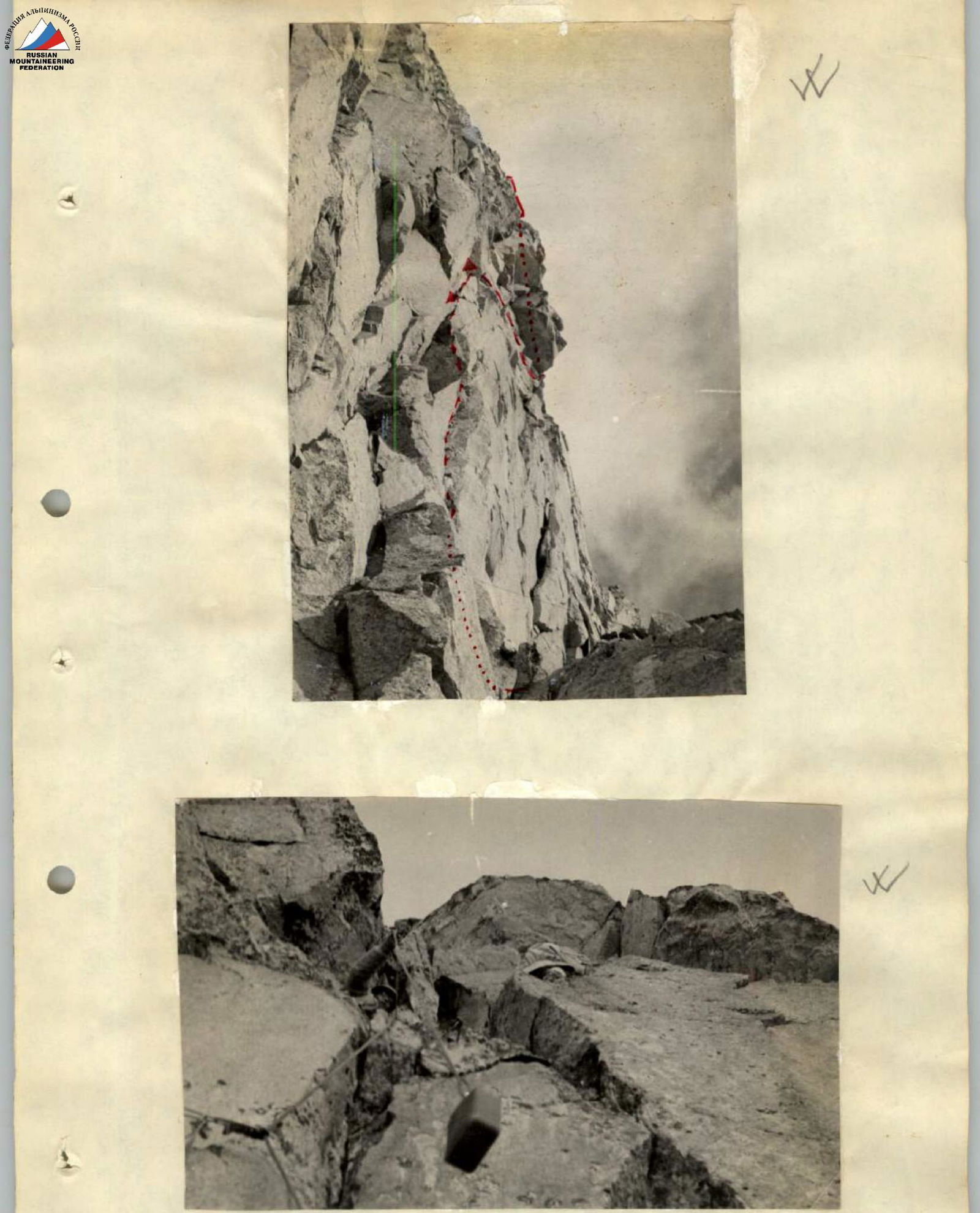
The Western wall presented отвесные, гладкие скалы with many overhanging cornices, few holds, and many wide vertical cracks. To the left-up-right led 3 cascades of holds, somewhat overhanging towards us. The rocks were separated from the main massif by vertical chimneys.
The Western wall presented отвесные гладкие плитообразные стены with many negative sections. A wide ledge encircling the wall in its middle part approached three large rocks (35–40 m each).
The rocks were separated from the main massif by narrow chimneys overhanging towards us. At the top of the wall, there was a large overhanging eave - "nose," clearly visible from the Uzunkol camp (Fig. 9).
The most logical path was to:
- pass as high as possible without using platforms and piton work, utilizing these rocks.
Overcoming the first cascade was complicated by an overhanging plug at the top of the chimney (section R17, Fig. 3).
Using ladders significantly facilitated the exit to the second tier. On this 45–50 m section, 8 pitons were hammered.
Difficult climbing awaited in the second chimney (section R18, Fig. 3), and again the most challenging spot was the exit to the top of the hold. At the top of R2 hold, there was a small gentle depression on an inclined ledge, where a platform for a lying bivouac for 4 people was set up. From here, Polyakovsky continued forward. The exit to the R2 tier (section R19, Fig. 3) was made via difficult rocks with simple climbing. From the third tier, along a sheer rock wall with a vertical crack, the route went straight up under a large overhanging rock. Before nightfall, Polyakovsky and Yakovina reached under the overhang, where they set up a hanging bivouac in hammocks. Below, 9–10 m down, Kononenko also set up a hammock. Three people bivouacked in a tent on top of the R2 hold.
July 24. Day 5.
Yakovina began traversing under the cornice along the sheer wall to the right at 07:00 AM.
Then, the lower team of three caught up with the upper group. To the right of the cornice, along steep slabs-blocks, straight up, using vertical cracks between blocks and hanging ladders, they ascended towards the pre-summit ridge. 30 m from the summit, they crossed a small ledge from the Western wall to the right onto a simple ridge.
At 02:00 PM, the entire group reached the summit. Next, they had to traverse the Eastern peak of Dvoynyashka and Zamok.
Between the Western and Eastern Dvoynyashka, a huge gendarme "Paltse" was visible from all sides, near which there were good bivouac sites for 1.5 tents. They began their descent towards these sites.
Along huge overhanging blocks of the Northern wall, they made three free descents straight under the gendarmes.
July 25. Day 6.
Bypassing "Paltse" on the right via ledges, then up the wall 20 m with many holds and to an internal angle (5 m), they reached the ridge of the Eastern Dvoynyashka, and then to the summit.
From the Eastern Dvoynyashka, they descended along the Northeast very steep ridge towards the saddle with Zamok. They made dülfer descents of 180 m, and twice used pendulum rappels.
The gendarme "Parus" on the saddle was bypassed on the right via a wide ledge. Then, they ascended along a destroyed rocky ridge for 80 m and traversed left along ice for 25–30 m to a snowy steep ascent (120 m) and onto the ridge of the Zamok massif.
Along a simple rocky-snowy ridge with ascents to gendarmes.
To the first gendarme, they ascended directly, descended to the right of the ridge along a crack into a depression. To the second small gendarme, they ascended along a smooth sheer wall with very difficult climbing. They descended from it via a 15 m rappel and bypassed the overhangs on the right via a narrow ledge, then along the ridge to the left to R1 gendarme. To it, they made a difficult ascent along blocks with overhangs (30 m). They reached the ridge along a 5 m wall. Along a simple ridge to the Western peak of Zamok.
They descended along the ridge, with some sections having:
- натёчный лёд;
- мокрый снег, to the Buraveстник pass via a 3B category route.
Darkness caught them on three ropes, not yet reaching the "Buraveстник" pass. They set up a bivouac on a huge slab, where they managed to pitch a tent.
July 26. Day 7.
They set out at 05:00 AM. They made an несложный спуск into the Dallar valley, crossed the Kichkinokol pass into the Uzunkol valley. At 12:00 PM, they arrived back at the camp.
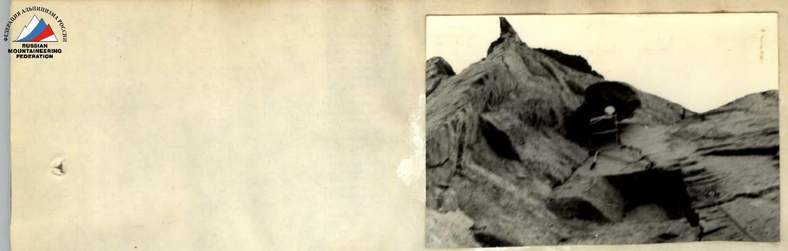
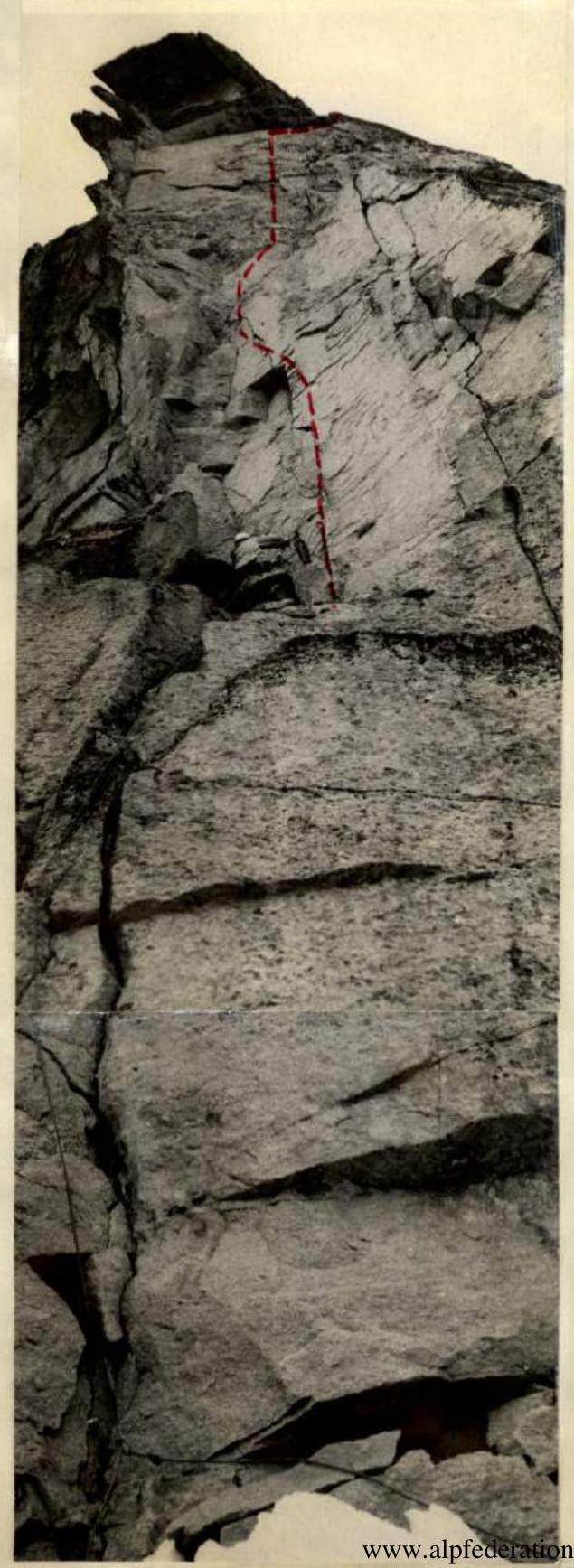
Table of Main Characteristics of the Route
| № п/п | Date | Section | Height gain (m) | Length (m) | Steepness (°) | Category of difficulty | Relief | Technical character of overcoming | Description of the section and its characteristics | Weather | Time of exit (h) | Walking hours | Pitons hammered (rock / pitons / wedges) | Notes |
|---|---|---|---|---|---|---|---|---|---|---|---|---|---|---|
| Average | ||||||||||||||
| 1 | July 19 | R1 | 40 | Icefall | 5:00 | From a/l "Uzunkol" | ||||||||
| 2 | R2 | 65 | 60 | 55 | Ice-firn couloir | Bergschrund is passed via a plug. Left-upwards and onto a rock ledge. | 10:00 | 4 | With a stop. | |||||
| 3 | R3 | 10 | 40 | 7 | Inclined ledge with a snowpatch | Traverse left along the edge of snow and rocks | Fog | 2 | ||||||
| 4 | R4 | 80 | 75 | 74 | Complex rocks | Upwards along an internal angle, inclined crack, wall with good holds. On R4 (bivouac site) left under an overhang, control cairn. | Fog | 19:00 | 12 / 2 / 2 | Stop for bivouac. Sitting on 4 people, lying on 2 people. | ||||
| 5 | July 20 | R5 | 4 | 85 | 4 | 4 | Complex rocks | Internal angle with few holds. | Light snow, fog, rain | 9:00 | 0.5 | 2 | ||
| 6 | R6 | 65 | 60 | 55 | Rocks | Slope with small inclined ledges | 9 | |||||||
| 7 | R7 | 40 | 40 | 25 | Snowy, icy slope | Traverse right to a small site with an ice anchor, up-left under a wall. | Rain | 3 / 1 / | Stop for bivouac at 16:00. Part of the ice cap was chopped out for two platforms. | |||||
| 8 | July 21 | R8 | 10 | 85 | 20 | 20 | Very complex rocks with vertical wide cracks. | Left, a 10 m ledge. Upwards along a crack to a 1×1.5 m platform. Difficult climbing. | Overcast | 9:00 | 3 / 2 / | 2 wedges | ||
| 9 | R9 | 90–95 | 70 | 70 | Sheer strong rocks with 4 overhangs. | Movement on platforms straight up. Part of the overhangs is bypassed on the right. | 13:00, wet snow, graupel | 8 / 16 / 11 / 1 | 1 wedge | |||||
| 10 | R10 | 50 | 60 | 45 | несложные скалы. | Exit to the shoulder via large blocks. | 0.5 | 2 | ||||||
| 11 | July 22 | R11 | — | 120 | 40 | Horizontal platform | On the shoulder, several ascents with несложные скалы. There are sites for 10–15 platforms. | Clear | 7:00 | 2 | One rope team bivouacked under the shoulder. Stop at 19:00. The first rope team processes the route, the rest exit to the shoulder. | |||
| 12 | R12 | 60 | 15 | Gendarme | несложный выход on the gendarme on the shoulder. | Clear | 1 | |||||||
| 13 | R13 | 15 | 8 | Ice saddle | Descent into a depression. | 2 / 1 / | ||||||||
| 14 | R14 | 15 | 0 | Rocks with a horizontal crack | Overcome by crawling. | 1 | ||||||||
| 15 | July 23 | R15 | 85 | 30 | 30 | Complex rocks | Internal angle with an overhang (5 m). Passed using platforms. | Fog | 5:00 | 1 / 2 / 1 | ||||
| 16 | R16 | 40 | Large blocks | Traverse right. | ||||||||||
| 17 | R17 | 90–95 | 45 | 45 | Chimneys with smooth walls | Exit using ladders. | 8 | |||||||
| 18 | R18 | 85–90 | 55 | 55 | Complex climbing, holds inside the chimney. | 6 | ||||||||
| 19 | R19 | 70 | 20 | 19 | Rocks of medium complexity | Internal angle. | 7 / 4 | On R2 hold, a platform for 4 people was set up. | ||||||
| 20 | R20 | 90 | 30 | 30 | Sheer wall with a vertical crack, rock cleavage. | Very complex climbing using ladders and platforms. | 8 / 1 | |||||||
| 21 | R21 | 95 | 30 | 30 | Internal angle | Overhanging sections with gentle ledges at the base. | 4 / 6 / 3 | 2 wedges. 3 people bivouacked in hammocks. | ||||||
| 22 | July 24 | R22 | 90 | 15 | Wall with an overhanging eave | Traverse under the cornice to the right. Movement on platforms. | Clear | 6:00 | 2 / 1 / 1 | 1 wedge | ||||
| 23 | R23 | 85 | 40 | 39 | Ridge, slabs | Complex climbing using ladders. | 4 / 7 / 2 | 1 wedge | ||||||
| 24 | R24 | 70 | 15 | 14 | несложные скалы | Exit right onto the pre-summit ridge. | 1 | |||||||
| 25 | R25 | 40 | 60 | 39 | Destroyed rocks | Walking to the summit. | 0.5 |
Total ascent to the Western peak of Dvoynyashka from the north covered about 700 m vertically, with almost 600 m being a technically complex route. 42 walking hours were spent (from the ice bivouacs). 102 rock pitons, 29 pitons, and 9 wooden and duraluminum wedges were hammered. Total of 140 pitons.
The descent from the summit followed a 5A category route to the saddle between Eastern Dvoynyashka and Zamok, and then they traversed Zamok towards Eastern Filter. From the Buravechnik pass, they descended into the Dallar valley and through the Kichkinokol pass back to the camp. On July 26, 1965, the ascent was completed.
West Dvoynyashka (3900 m)


