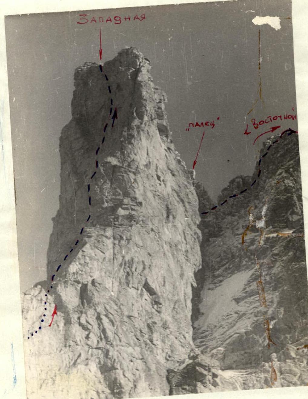
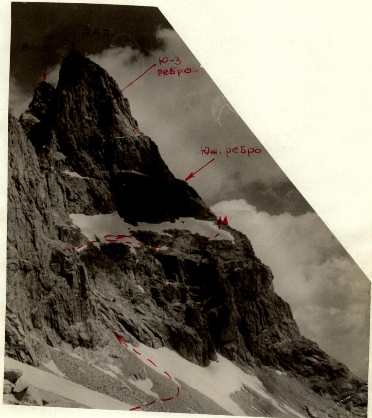
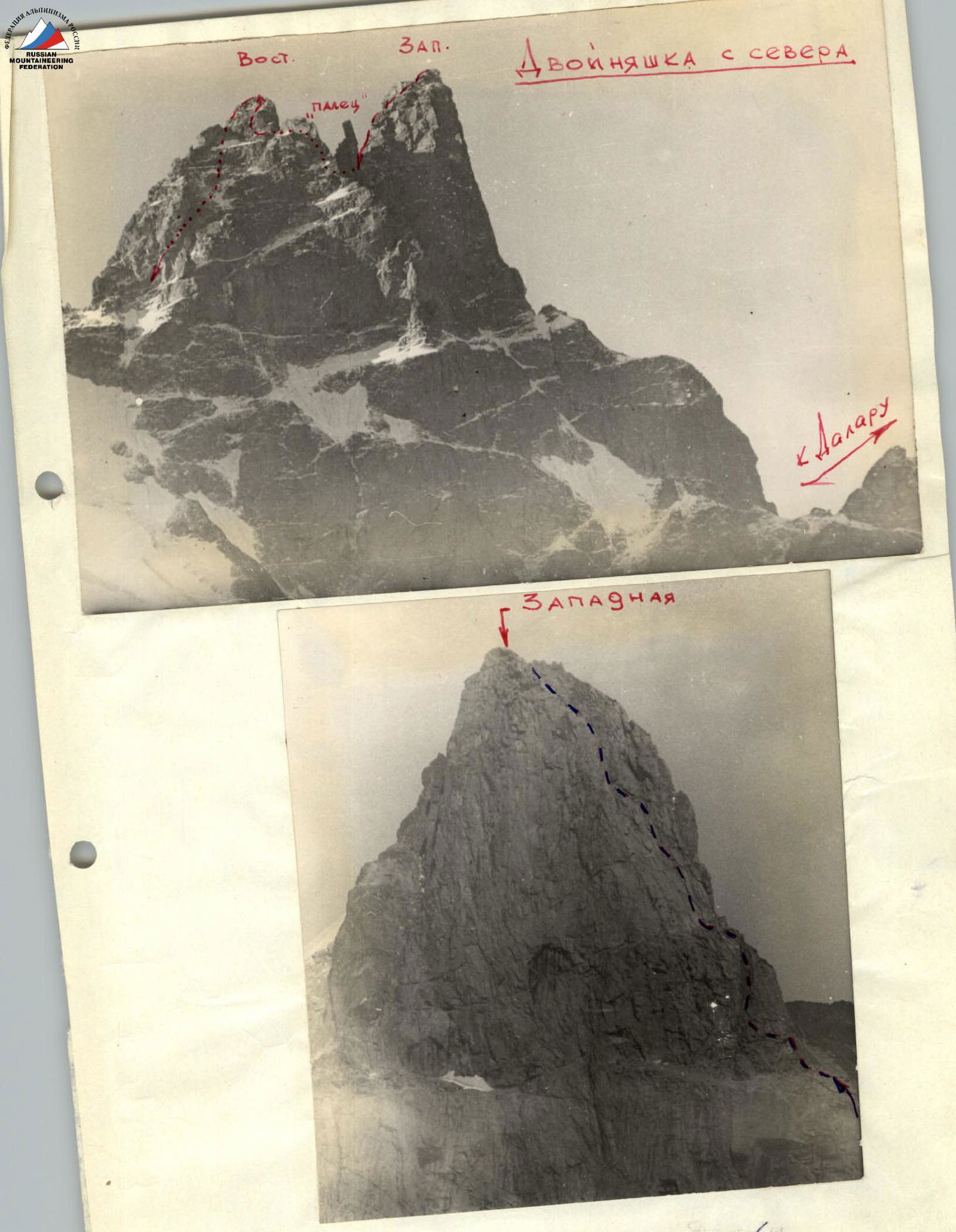
Dvoinyashka Peak — 3800 m
Traversing the Western and Eastern peaks (Description of the route as you move towards the summit)
From the "Uzunkol" camp, follow the right bank of the Mordy River to the first koshi, cross the bridge to the left bank, and follow the trail to a large talus accumulation in the gorge. After the talus, follow the riverbank to the start of the ascent up the left, grey, large moraine. Ascend along the ridge to a clearly defined confluence of two moraine ridges. From here, descend left from the moraine via a trail and ascend a grassy slope to a terrace, then continue up slopes and scree to reach the large-boulder moraine. Cross it to reach the Dalar Glacier plateau. Crossing the plateau, approach the slopes of the Dalar pass. Ascend a snowy slope to a terrace before a steep snowy ascent (80 m, 50°). In rope teams, ascend to the bergschrund — cross via a bridge and a gap (belay!). Beyond the bergschrund, ascend a snowy slope to the Dalar pass. There are platforms on the rocks. From the camp, it takes 5.5–6 hours.
From the Dalar pass, descend left and down, bypassing the southern ridge of Dalar Peak, and follow the scree left of the "ram's foreheads" to the upper part of the cirque between Dalar and Dvoinyashka peaks, to the 1st narrow couloir on the left.
Ascend the couloir (in rope teams!) 50 m up and exit to a scree terrace. From the terrace, go right through a snowpatch and then along the "ram's foreheads" (belay!) — exit right and below the saddle between Dalar and Dvoinyashka peaks.
From here, traverse right along a large terrace, through a snowpatch, to a rocky outcrop, and from it descend to a depression in the southern ridge of the Western Dvoinyashka peak. Ascend 50 m straight up along broken rocks to the base of the ridge — a bivouac site. From the Dalar pass, it takes 4 hours.
From the bivouac, ascend along the ridge 130 m (Belay! Pitons!) mostly on its left side to a platform before a couloir. Ascend straight up the couloir 20 m (Belay!) to the next platform.
From here, ascend left and up 10–12 m (belay!) via a crack to a pronounced inclined cleft. Follow the cleft 12–15 m (belay! Pitons!) — exit to a small ridge, and from here go right and up to a platform below an 80 m grey wall (Belay! Pitons!).
From the platform:
- ascend right and up via an internal corner 6 m (pitons!) to a ledge;
- then ascend straight up a crack 5 m (pitons!) to the next ledge;
- follow it right 5 m;
- and from here 15 m (Belay! Pitons!) straight up;
- then ascend 40 m along a rocky ridge to its depression (this is the southwestern ridge of the Western peak).
From here, bypass нависающих скал (very difficult climbing! Careful belay!) from right to left (Belay! Pitons!) and via an internal corner 20 m — exit back onto the ridge.
From it, go right along rocks (belay!) to a scree-filled couloir (pitons!), ascend it to scree, and after 40 m — exit to the Western peak. From the bivouac, it takes 10–12 hours.
From the peak, descend initially left and down (towards the saddle between the Western peak and the "Finger") to a detached slab. From here, descend 40 m via rappel, then another rappel 30 m to an inclined ledge, from which rappel 25 m to a platform before the saddle. Along rocks — 15 m descend to the saddle to the "Finger". From the saddle, go right and down 3 m and then bypass the "Finger" (pitons!) to a 3-meter wall, ascend the wall and then to an inclined ledge (pitons!) and along it bypass — right of the external corner (pitons!) — exit to the saddle between the "Finger" and the Eastern peak.
From the saddle, traverse 40 m (Pitons! Difficult!) up to the middle part of a couloir. Cross it right and then along difficult rocks (pitons!) straight up 40 m to a rocky pocket with snow.
From here, go left into the couloir and along it 15 m (pitons!) — exit to a large scree-filled couloir.
Ascend the couloir 55–60 m and along broken rocks — exit to the Eastern peak. From the Western to the Eastern peak, it takes 4–5 hours.
From the peak, descend initially along the ridge of the Southern ridge 150 m to the start of a ridge drop — a slab (pitons!). From the slab, descend 20 m via rappel to a detached slab and along it rappel-pendulum left and down (pitons!) to a small ledge. From here, descend 40 m via rappel to a large inclined slab with snow (a sharp drop of the Southern ridge). From the slab, go left and down to a scree ledge and along it 150 m to its bend.
Further descent:
- 40 m (pitons!) along the ledge — exit to a rocky couloir with a stream;
- bypass the couloir left and down 15 m along it (pitons!), enter the couloir and descend 40 m via rappel to an inclined platform (pitons!);
- from the platform, descend 5 m and then rappel 40 m to a rocky outcrop (pay attention to the rope's position — it gets jammed!);
- from here, again 40 m rappel to the confluence of two snowy couloirs (they have gullies! Rocks! Dangerous!).
Further:
- descend on the right side of them (pitons!) diagonally via rappels 100 m;
- from here, crossing the couloir (belay!) — exit to rocky ledges;
- initially with two rappels, and then along scree ledges — descend 230 m to an outcrop dividing the couloir in two.
From the outcrop:
- left of the left couloir;
- bypassing the outcrop on the left — traverse right and down (pitons!) — exit to scree;
- along the scree — to a passage between two characteristic rocky outcrops (on the right);
- further along the scree — to the Dalar–Dvoinyashka cirque;
- via the approach route — return through the Dalar pass to the camp.
Descent from the Eastern peak to the scree ledge takes 8–9 hours. From the ledge to the Dalar pass — 4 hours. From the Dalar pass to the camp — 4–5 hours.
Switching on a cornice
For the first time!