USSR ALPINISM FEDERATION.
Report
ON THE ASCENT OF V. DVONYASHKA WEST VIA THE SOUTHEAST FACE. CATEGORY 5B. SECOND ASCENT RSFSR TEAM 650, 1050 gr., 500, 79°, 58 vsk, 18 sm, 1/2, 2/6, 88 zam. 21 hours, 2 days. Balkin S.G., Baezin V.V., Bogachev A.V., Bogomaz V.V., Zakharov N.N., Chentsov S.V. (Kr-n) February 6-7, 1983.
| Team Captain | Bayakin S.G. |
|---|---|
| Senior Team Coach | Sapozhnikov Yu.G. |
| Team Coach | Mashkov Yu.V. |
1983 Addresses: Krasnoyarsk Kraisportkomitet 660064, Krasnoyarsk, Ostrov Otdykha. Tel. 361-510, 361-610 Bayakin Sergey Gennadievich 660017, Krasnoyarsk, ul. K. Marksa, 135-40 Tel. 224-224 Sapozhnikov Yuri Georgievich 660037, Krasnoyarsk, ul. Kolomenskaya, 24-22. Tel. 338-634 Mashkov Yuri Viktorovich 115477, Moscow, Proletarsky pr-t, d. 64, k. 4, kv. 95. Tel. 3-25-25-40 Bogachev Alexander Viktorovich 660099, Krasnoyarsk, ul. Zheleznodorozhnikov, 14-2.
The heights of points on the route mentioned in the report were determined using an altimeter, while the heights of photography points were estimated visually.
UIAA Scheme and Table
Left Part of the Table
| SK | ICE | BELAY | PITS |
|---|---|---|---|
| 1 | 2 | 3 | 4 |
| 12 | 10 | 17 | 15 |
| Climbing hours | – | 9 | |
| Height difference | – | 310 m | |
| 23 | 3 | 32 | 4 |
| 6 | 7 | ||
| 2 | 2 | ||
| 4 | |||
| 3 | 3 | ||
| 4 | 2 | ||
| 3 | 4 | ||
| 3 | 4 | ||
| Outcrops | |||
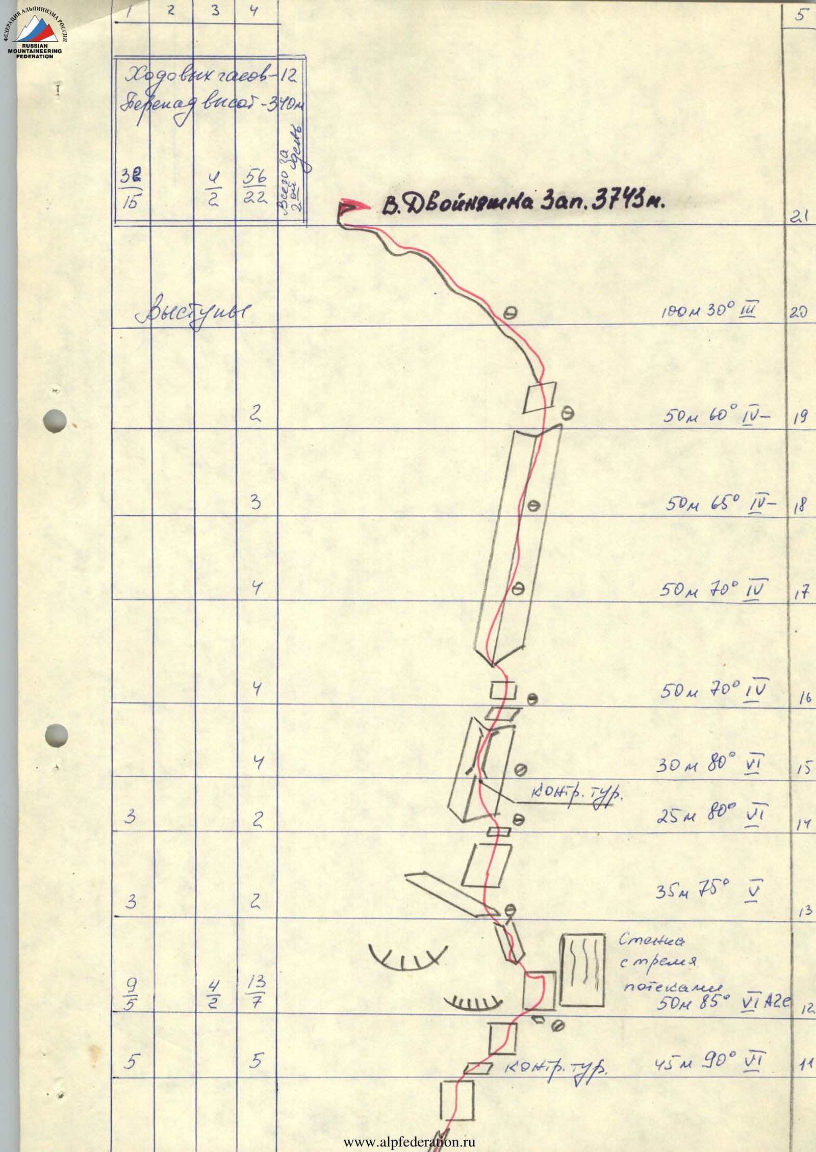
| 3090 m. | Start of the route. | 70 m 60° IV– | R0 |
| Climbing hours | – | 12 | |
| Height difference | – | 340 m | |
| 32 | 15 | 56 | 22 |
| V. Dvoynashka West | – | 3743 m. | R21 |
Right Part of the Scheme
| Section | Length | Steepness | Category |
|---|---|---|---|
| R11 | |||
| R10 | 55 m | 90° | VI A310 |
| R9 | 50 m | 90° | VI |
| R8 | 60 m | 45° | III |
| R7 | 45 m | 70° | V |
| R6 | 50 m | 70° | V |
| R5 | 45 m | 80° | V+ |
| R4 | 20 m | 80° | VI |
| R3 | 50 m | 70° | V+ |
| R2 | 40 m | 45° | III |
| R1 | 80 m | 65° | IV+ |
| R0 | 70 m | 60° | IV– |
| R21 | |||
| R20 | 100 m | 30° | III |
| R19 | 50 m | 60° | IV– |
| R18 | 50 m | 65° | IV– |
| R17 | 50 m | 70° | IV |
| R16 | 50 m | 70° | IV |
| R15 | 30 m | 80° | VI |
| R14 | 25 m | 80° | VI |
| R13 | 35 m | 75° | V |
| R12 | 50 m | 85° | VI A20 |
| R11 | 45 m | 90° | VI |
Control cairn marked for sections R6, R14, R11 (on the diagram).
Brief Explanation of the Table (see UIAA scheme)
R0–R3 Simple rocks, partially snow-covered.
R3–R5 Movement along the bastion wall; on the monolithic wall, two cracks with very damaged edges. When passing the cornice at the top of the wall, do not go left, where a piton of the first ascenders and two hooks are "live" blocks!!! Move along the right crevice. There are many "live" stones on the wall. Climbing is very difficult. Bypassing the bastion on the right is extremely dangerous, as all stones and avalanches from the upper walls and couloir fly here.
R5–R8 Very steep little walls, alternating with ledges. Control cairn.
R8–R9 Snow slope, exit to the base of the huge couloir between West and East Dvoynashka. To the left, a narrow rocky ledge departs, which expands to four meters after the bend. Excellent overnight stay, protected by a huge cornice from stones and rain. (See photo No. 3)
R9–R11 Start moving along the wall from the very base of the large snow couloir from a small ledge (see photo No. 4) through a two-meter cornice (passage of the first with a boost). Then move along the vertical wall with a strong deviation to the right. Very difficult climbing! If necessary, returning along the ascent route is very difficult. Returning straight down is possible if there are enough ropes all the way down (see photos No. 5, No. 6). At the end of the section, there is a large sloping ledge. Control cairn. Overnight stay is possible. If necessary, it is possible to deviate from the route along the oblique ledge to the left, onto the 5A route.
R11–R12 From the cairn, move right-upwards, towards the gray wall with three streaks. Very difficult!
R12–R13 Move straight up to the left of the slab with streaks, where 4 pitons are driven. At the beginning of the section, the steepness is more than 90°. After the bend, move left-upwards, and along the clearly defined inner corner with a crevice, exit onto a good ledge.
R13–R14 Monolithic wall, good holds, organizing belays is difficult.
R14–R15 From a small rocky ledge, move in the direction of the chimney, under the chimney in a "bank" on a hook, there is a control cairn.
R15–R16 Move along the chimney, and then along inclined slabs. Exit under a huge inner corner. Climbing is difficult.
R16–R19 Climb along the corner-chimney. Move carefully, as it is practically impossible to shelter in the corner from stones dropped from above.
R19–R21 Exit to the summit part of the tower. SUMMIT!
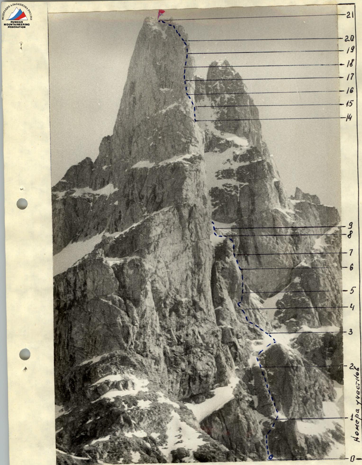
Photo No. 2. V. Dvoynashka, view from the southwest. Taken on July 2, 1983, at 11:00 from a distance of 2500 m, height of the shooting point — 3100 m, lens — Jupiter-37A 1:870, f = 135 mm.

