Ascent Passport
- Ascent class — ROCK.
- Ascent area — GVANDRINSKY REGION OF THE CAUCASUS.
- Peak — DALAR, 3979 m, LEFT PART OF THE NORTH FACE.
- Difficulty category — 5B.
- Route characteristics: a) height difference — 895 m, b) length of 5th category sections — 430 m, 6th category — 360 m, total — 1100 m.
- Pitons hammered:
| Type of pitons | For belay | For creating ITO | Total |
|---|---|---|---|
| 1. Rock | 109(22) | 18(10) | 127(32) |
| 2. Ice | 0 | 0 | 0 |
| 3. Bolts | 2(2) | 6(6) | 8(8) |
| 4. Chock stones | 25 | 10 | 35 |
| TOTAL: | 136(24) | 34(16) | 170(40) |
Note: previously hammered and used by the team pitons are indicated in parentheses.
- Number of climbing hours — 41 h 30 min, including 6 h descent from the summit.
- Number of overnight stays and their characteristics: 2 sitting with tent setup.
- Team composition: Pronin A.V. — leader, Malamid V.M. — participant, Korenyugin I.K. — participant, Dorokhov B.F. — participant.
- Team coach — Dorokhov B.F.
- Date of departure on the route — July 20, 1984 at 16:00, date of return — July 23, 1984 at 22:00.
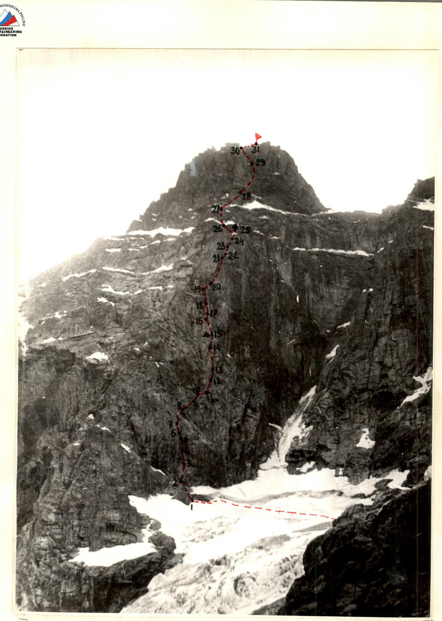
GENERAL VIEW OF THE ROUTE (Shooting date: July 18, 1984; 17:00)
Table of main characteristics of the ascent route

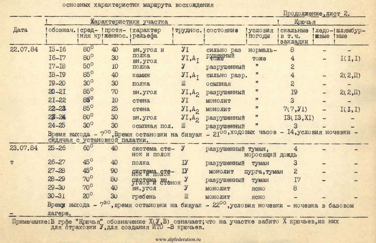
| Date | Designation | Average steepness | Length, m | Terrain character | Difficulty | Condition | Weather conditions | Pitons: rock (including chocks) | Pitons: ice | Pitons: bolts |
|---|---|---|---|---|---|---|---|---|---|---|
| July 21, 1984 | R0–R1 | 20° | 800 m | snow | 2 | overcast | ||||
| R1–R2 | 70° | 30 m | wall | 3 | destroyed | overcast | 2 | |||
| R2–R3 | 80° | 30 m | wall | 4 | monolith | normal | 3 | 1 | ||
| R3–R4 | 85° | 20 m | inner corner | 6 | monolith | same | 5(5,IV) | |||
| R4–R5 | 85° | 20 m | wall | 6 | monolith | — | 8(8,VII) | |||
| R5–R6 | 80° | 15 m | inner corner | 6 | monolith | — | 4 | |||
| R6–R7 | 80° | 20 m | wall | 4 | monolith | — | 2 | 1 | ||
| R7–R8 | 80° | 40 m | system of inner corners and walls, up-right | 4 | monolith | — | 8 | |||
| R8–R9 | 75° | 40 m | wall | 6 | monolith | — | 7 | |||
| R9–R10 | 80° | 20 m | wall | 4 | monolith, water | — | 4 | |||
| R10–R11 | 30° | 20 m | ledge, crossing waterfall | 3 | — | 2 | ||||
| R11–R12 | 80° | 50 m | wall | 4 | monolith | — | 4 | |||
| R12–R13 | 70° | 40 m | wall, ledges with stones | 4 | monolith | — | 4 | |||
| R13–R14 | 75° | 80 m | system of walls and ledges | 4 | destroyed | — | 7 | |||
| R14–R15 | 70° | 40 m | inner corner | 4 | destroyed | — | 5 | |||
| Time | Departure — 5:00, stop for bivouac — 20:00, climbing hours — 13, bivouac conditions — sitting with tent setup. | |||||||||
| July 22, 1984 | R15–R16 | 80° | 40 m | inner corner and ledge | 6 | heavily destroyed | normal | 8 | ||
| R16–R17 | 80° | 30 m | inner corner | 6 | destroyed | same | 4 | 1(1,1) | ||
| R17–R18 | 50° | 10 m | ledge | 4 | destroyed | — | 2 | |||
| R18–R19 | 85° | 40 m | chimney | 6 | heavily destroyed | — | 4 | 2(2,II) | ||
| R19–R20 | 30° | 30 m | ledge | 3 | scree | — | 2 | |||
| R20–R21 | 85° | 70 m | inner corner | 6 | destroyed | — | 19 | 2(2,1) | ||
| R21–R22 | 85° | 10 m | wall | 6 | monolith | — | 3 | |||
| R22–R23 | 85° | 25 m | wall | 6 | monolith | — | 7(7,VI) | 1(1,1) | ||
| R23–R24 | 80° | 30 m | inner corner | 6 | destroyed | — | 13(13,XI) | |||
| R24–R25 | 30° | 30 m | scree ledge | 3 | destroyed | — | 3 | |||
| Time | Departure — 7:00, stop for bivouac — 21:00, climbing hours — 14, bivouac conditions — sitting with tent setup. | |||||||||
| July 23, 1984 | R25–R26 | 60° | 40 m | system of walls and ledges | 4 | destroyed | fog, drizzling rain | 4 | ||
| R26–R27 | 45° | 40 m | ledge | 4 | destroyed | fog | 3 | |||
| R27–R28 | 45° | 90 m | system of walls and ledges | 4 | monolith | blizzard, fog | 2 | |||
| R28–R29 | 70° | 80 m | system of walls | 4 | destroyed | fog | 17 | |||
| R29–R30 | 70° | 40 m | inner corner | 4 | monolith | clear | 8 | |||
| R30–R31 | 20° | 30 m | ridge | 3 | monolith | clear | ||||
| Time | Departure — 7:30, stop for bivouac — 22:00, bivouac conditions — overnight stay in the base camp. |
Note: in the "Pitons" column, the designation X(Y, C) means that X pitons were hammered on the section, of which Y were for belay, and C pitons were for creating ITO.
Tactics of the Ascent
I. This section contains information about the actual implementation of the team's tactical plan.
-
The team left the bivouac under the route at 5:00. Weather conditions: overcast, light rain. The basis for going on the route in these weather conditions was:
- a) results of weather observation during the period from July 14–20 (as a rule, rain and bad weather at night and in the morning, clear and sunny weather during the day);
- b) barometer readings in the "Uzungol" camp (did not change);
- c) weather forecast (good).
The decision to depart was made by the captain after discussion with the team. The following plan of action was outlined:
- a) approach to the "Stepanovskaya Polka" (start of the route);
- b) in case of improving weather — actions according to the tactical plan;
- c) in case of continued bad weather — wait until 11:00 (approximate time to reach possible bivouac sites — 8 hours), in case of improving weather — actions according to one of the additional graphs of the tactical plan;
- d) in case of continued bad weather after 11:00 — return to the bivouac and shift the ascent schedule by one day.
-
At 6:00 they were at "Stepanovskaya Polka". They tied up in pairs: Pronin — Korenyugin; Malamid — Dorokhov.
At 7:00 they started on the ledge and, due to clear signs of improving weather, began moving along the route. The condition of the route is satisfactory.
Order of team movement:
- first — Malamid;
- second — Dorokhov;
- third — Pronin;
- fourth — Korenyugin.
-
As expected, the route after the first rope was very difficult and represented a system of walls, cornices, internal corners, sometimes heavily destroyed, which required special attention and caution when moving and organizing belays.
-
The team used five ropes on the route, which ensured the possibility of applying the basic principle of belay organization used by the team on all complex ascents: each participant works on a double rope. In addition, having five ropes made it possible to minimize downtime of the first rope team due to the lack of ropes necessary for processing the next section. Due to the fact that the route is complex throughout, the second pair almost always managed to provide the first pair with the necessary equipment for further work.
-
The passage of the first key section (4 ropes) took 7 h 30 min (according to the tactical plan — 5 h). The delay was associated with unstable weather at the beginning of the team's work on the wall.
-
The second key section (one rope — traverse to the right and one rope — ascent along the waterfall) turned out to be less difficult than expected when drawing up the tactical plan. This is explained by the state of the route at the time of passage. Overcoming the section took 2 h (according to the tactical plan — 3 h).
-
By 17:00 on July 21, 1984, the team reached point R12 (see table of characteristics and ascent passport). The section R12–R15 (4 ropes) was passed in 3 h. It represents a system of internal corners and walls with frequently encountered ledges. Some areas are heavily destroyed. There was practically no snow on the section.
-
At 20:00 the team stopped for a bivouac at the "finger" top (R15 point) (in accordance with the tactical plan). A sitting bivouac with tent setup was organized. The team spent about 13 h to overcome the section of the route from point R2 to point R15, which corresponds to the tactical plan.
-
On July 22, 1984, the team started on the route according to the main movement schedule of the tactical plan at 7:00. Weather conditions are normal.
-
The section of the route from the "finger" top to the beginning of the 120-meter inner corner (key 3) is characterized by strong rock destruction with high technical complexity.
-
Order of team work: first — Korenyugin, second — Pronin, third — Malamid, fourth — Dorokhov. The section was passed in 8 h (according to the tactical plan — 5 h). Additional time was required to strengthen safety measures due to strong rock destruction (more cautious climbing of the first, in addition, the team had to gather together twice to avoid working above each other). At 15:00 the team began to pass the 120-meter inner corner, defined as the most difficult section by all teams that had previously passed the Spesarov or Shopin route. According to the information available to the team, there were opportunities to organize a sitting bivouac on section R19–R20 and at point R21 (teams from Leningrad, which passed the Shopin route as part of the 1983 USSR Championship). In case the team did not have time to pass the inner corner before dark, a night's stay at one of these points was supposed.
The order of team movement was changed as planned and became as follows:
- first — Pronin;
- second — Korenyugin;
- third — Dorokhov;
- fourth — Malamid.
The complexity of the section corresponded to that described in the reports on ascents of teams as part of the 1983 USSR Championship. The team spent 6 h on the passage of this section (according to the tactical plan — 8 h). Time savings are explained by thorough preparation of the first for the passage of this section and his clear actions, a significantly smaller number of destroyed rocks than expected, direction of movement to the right and upward, which made it possible to work without fear of stones being thrown down by the preceding climber. In addition, changing the leader and having the second, the most technically strong in rock climbing, go forward with fresh strength instead of the first, who had already worked on 6 complex ropes, made it possible to speed up the team's work.
Note: According to the tactical plan, the second in the team should always be ready to replace the first, and therefore his backpack is also lightened relative to the backpacks of the third and fourth numbers.
-
The inner corner leads to a steep 30-meter ledge with a snow patch at a vertical rock wall with a cornice. A platform was trampled between the wall and the snow patch, and a tent was hung on pitons, in which a sitting bivouac was organized. The team stopped for a bivouac at 21:00. In total, on July 22, 1984, 14 h were spent (according to the tactical plan — 13 h).
-
On July 23, 1984, the team started on the route at 7:30. The order of movement is according to the tactical plan:
- first — Korenyugin;
- second — Pronin;
- third — Malamid;
- fourth — Dorokhov.
The section of the route from the bivouac site to the summit is almost entirely rock and is less complex than the part of the route passed in the first two days. The most difficult are the first three ropes and the last two ropes of the tower. The passage of the route on this day was complicated by bad weather conditions (fog, rain, sometimes with snow). In this connection, the team's movement scheme remained the same, although it was supposed to move in pairs without securing the rope in the middle section. Since during the training cycle almost every ascent ended in bad weather, the team expected and was ready to work in bad weather, which made it possible to complete all the tactical tasks set for this day.
In conditions of poor visibility when passing the middle part of the "roof," the team deviated slightly to the left and, due to even more deteriorating weather, began to prepare a place for a bivouac. Around 13:00 the weather improved, visibility appeared, and it was decided to continue the ascent. The team oriented itself and continued further movement along the previously planned ascent path.
-
At 16:00 on July 23, 1984, the team reached the summit (according to the movement schedule, it was planned to reach the summit at 15:00). Weather conditions were excellent during the ascent to the summit.
-
They began their descent from the summit at 16:20 and were in the base camp at 22:00. The weather deteriorated during the descent, and visibility decreased to 40 m. On the Dalar Pass at 19:00 the team met observers and, having contacted the base camp, reported the completion of the ascent.
-
The technical characteristics of the route are given in the table of main characteristics of the ascent route. In addition, a route sheet of the ascent is provided in the additional materials. The diagram of the route in UIAA symbols used by the Ukrainian Sports Committee team for orientation on the route practically fully corresponds to the route reflected in it.
-
During the ascent, two hot meals were organized (in the morning, before departure on the route, and in the evening, after setting up a bivouac). During the day, participants used individual packs for nutrition. The composition of the food products is given in the "Team Supply" section.
-
The team did not use fundamentally new samples of equipment during the ascent.


