2012 Ukraine Championship
Rock Class
Classification Commissions:
- FALS of Ukraine
- FAR
Report
on the first ascent of the route to v. Dalar (3979 m) along the center of the north-eastern wall of the bastion (proposed 6A cat. diff.), made by the team of the Poltava Regional Federation of Mountaineering and Rock Climbing
Leader: Pugachev S.A., MS, instructor-methodologist II category.
Coach: Zagirnyak M.V., Honored Trainer of Ukraine, MS
2012
Poltava Regional Federation of Mountaineering and Rock Climbing
Chairman Zagirnyak Mikhail Vasilyevich Ukraine, 39600, Kremenchug, st. Lenina, 3A apt. 7
Team leader Pugachev Sergey Alexandrovich. Team coach Zagirnyak Mikhail Vasilyevich mzagirn@kdu.edu.ua
Ascent Passport
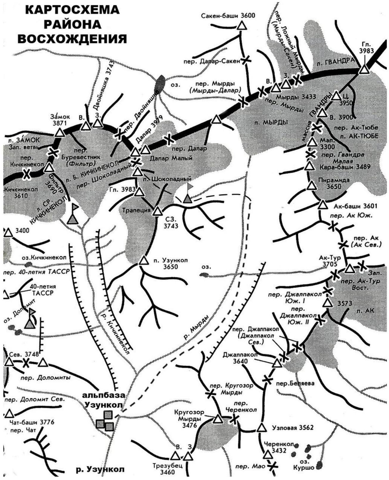
- Western Caucasus, Gvandra region, section 2.3 according to KMGV.
- Peak Dalar (3979 m), along the center of the north-eastern wall of the bastion (Pugachev-Zagirnyak route).
- Proposed 6A cat. diff., first ascent.
- Route type: combined.
- Height difference of the route:
height difference from the start of the rock part - 960 m, height difference of the bastion - 560 m. Route length: 1450 m. Length of sections:
- 5 cat. diff. of the bastion - 367 m
- 6 cat. diff. of the bastion - 142 m. Average steepness:
- wall of the bastion - 72°
- entire route - 63°
- Number of pitons driven (including in the denominator for ITO):
rock pitons ice pitons bolt pitons removable protection
106/68 0/0 23/9 at stations 35/9
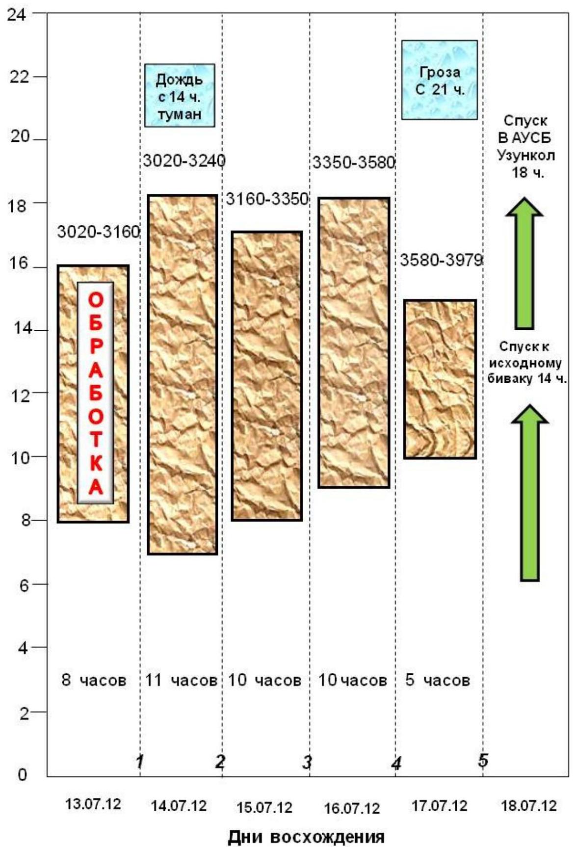
- Team's walking hours: 44 hours, days - 3.5.
- Number of overnight stays and their characteristics:
Initial bivouac - on the left-bank moraine of the Kichkinokol glacier;
List:
- 1st - in a tent on a convenient platform;
- 2nd - in a tent on a sloping platform;
- 3rd - in a tent on the "roof" of the bastion.
- Leader: Pugachev Sergey, MS;
participant: Zagirnyak Mikhail, MS.
- Team coach: Zagirnyak Mikhail, MS, HTU
- Departure from the base camp to the route: July 12, 2012; Route started: July 13, 2012. Reached the summit: July 17, 2012; Returned to AUSB "Uzunkol": July 18, 2012.
- Organization: Poltava Regional Federation of Mountaineering.
- Responsible for the report: M. Zagirnyak, mzagirn@kdu.edu.ua

Photo 1. General photo of the peak Dalar (3979 m), along the center of the north-eastern wall of the bastion (taken with a CANON S-90 camera with a 80 mm focus)
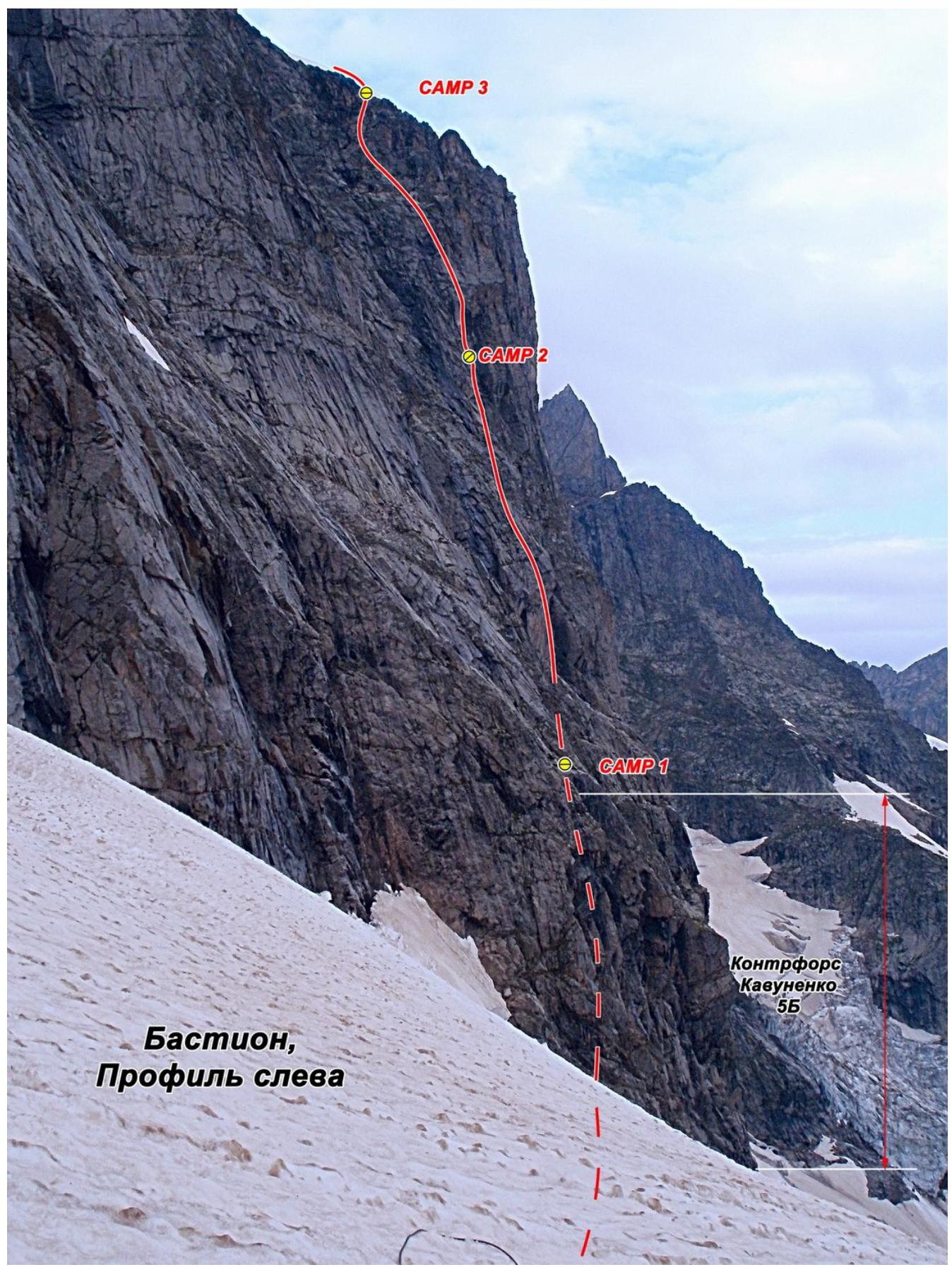
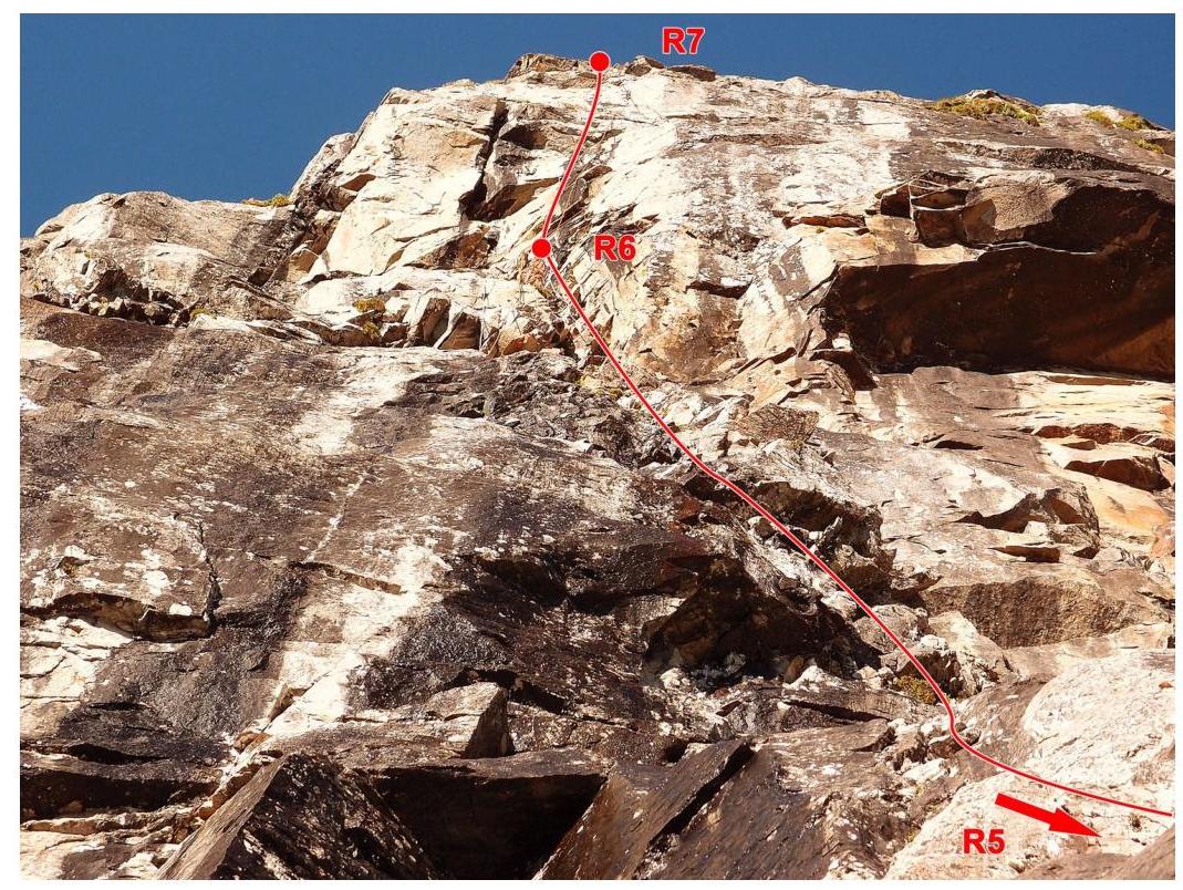
Photo 2. Route profile from the left (taken with an OLYMPUS XZ-1 camera with a 50 mm focus)
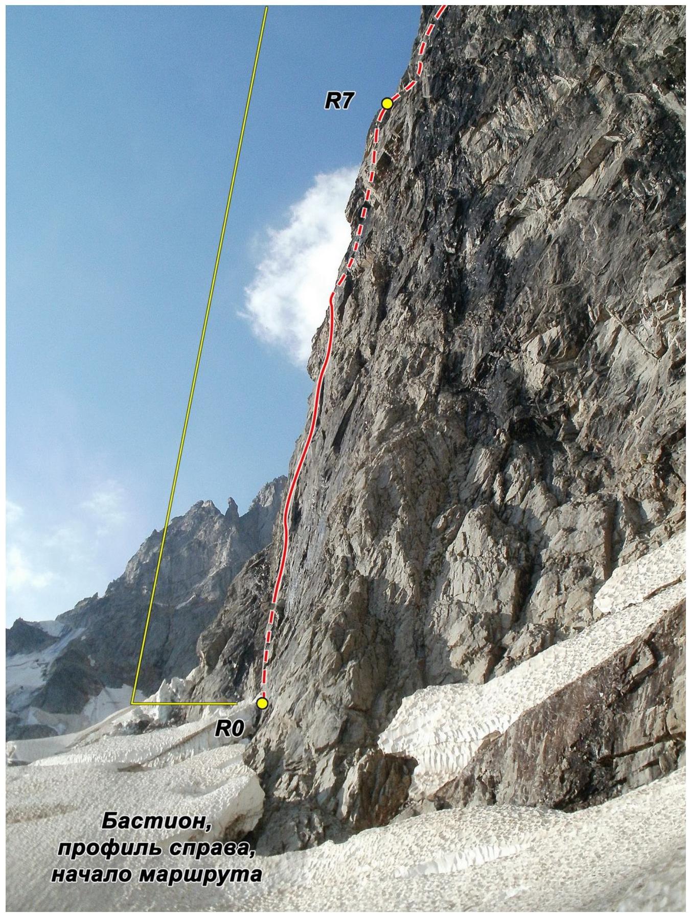
Photo 3. Route profile from the right (taken with an OLYMPUS XZ-1 camera with a 50 mm focus)
Drawn profile of the route M 1:4000
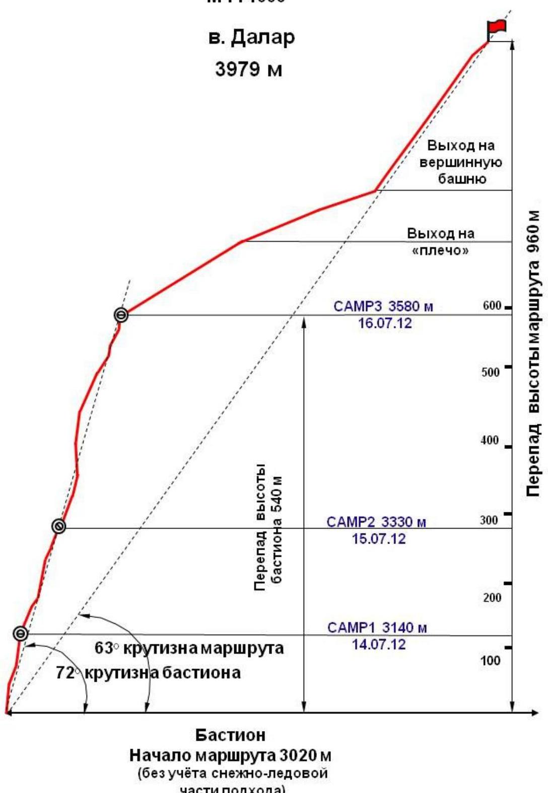
Photo 4. Profile of the route to peak Dalar (3979 m) along the center of the north-eastern wall of the bastion
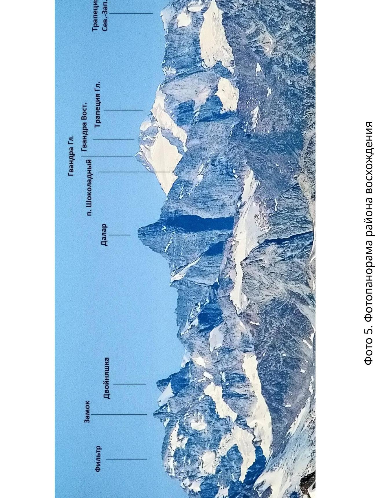
Photo 5. Panorama of the ascent area
Ascent Area Map
 Route map in UIAA symbols Dalar, 3979 m., Pugachev-Zagirnyak route, first ascent, 6A (approximately)
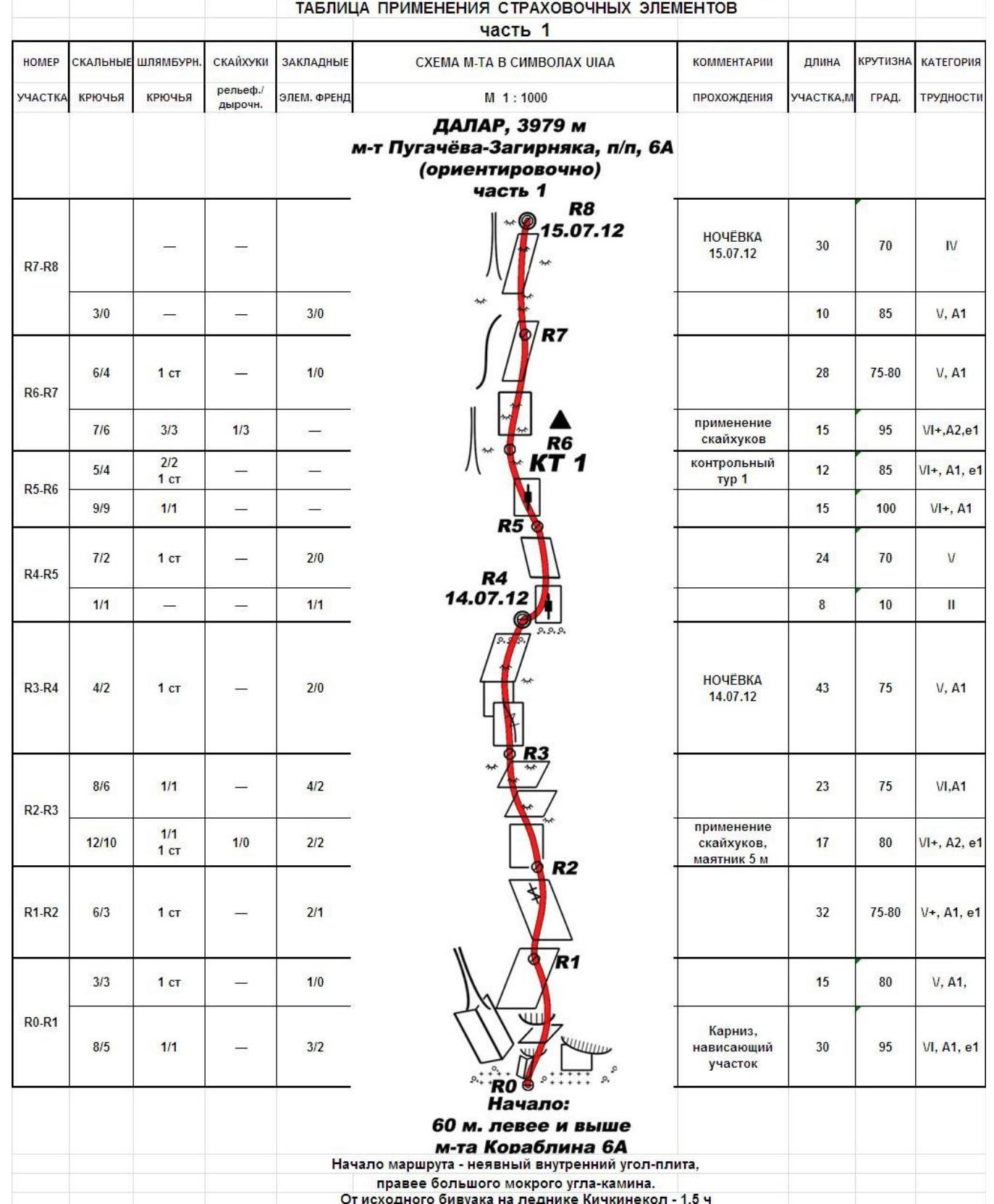
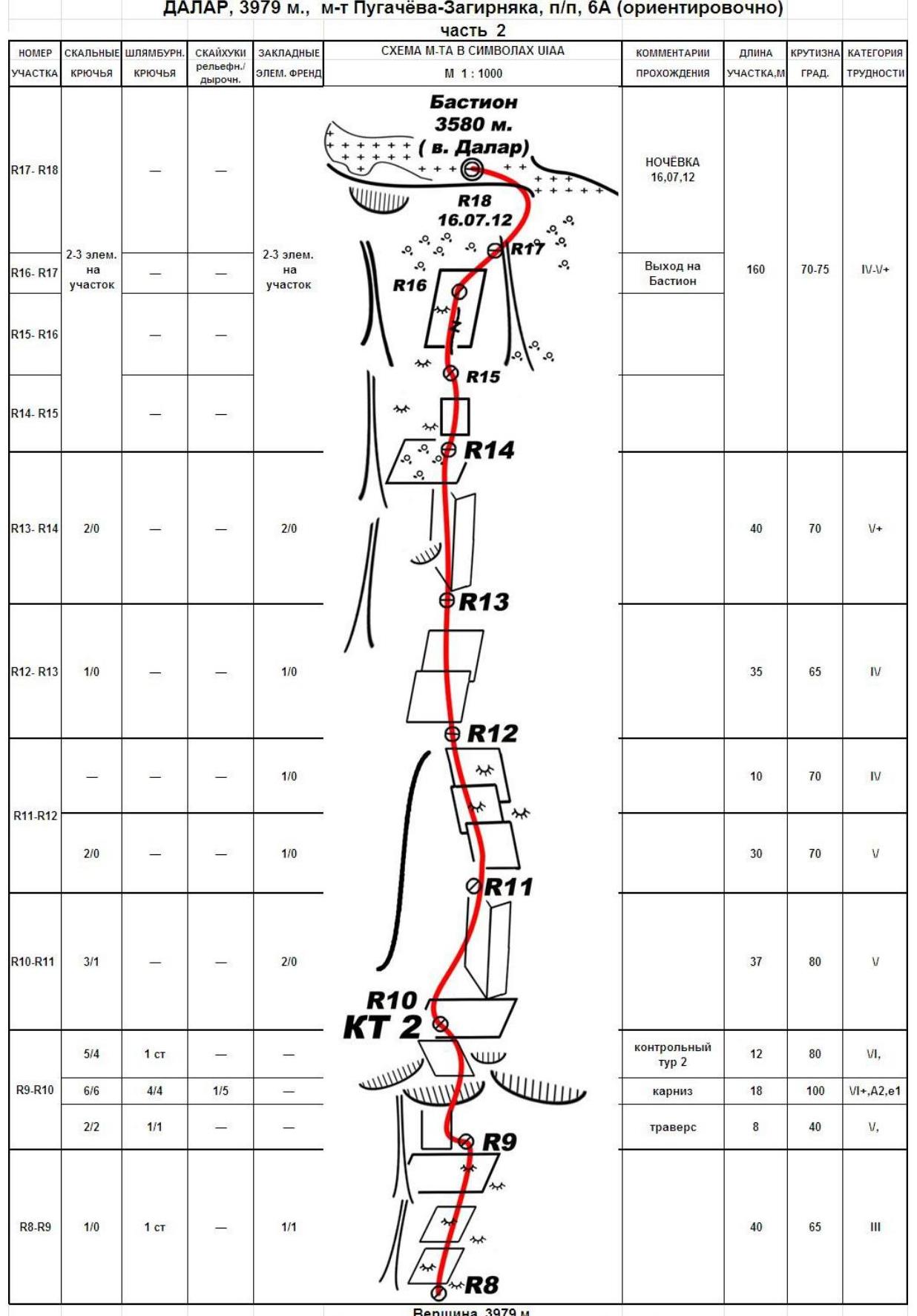
Table of insurance elements usage
 Route map in UIAA symbols Dalar, 3979 m., Pugachev-Zagirnyak route, first ascent, 6A (approximately)
Summit, 3979 m
Bastion length 692 m
Height difference of the bastion 660 m
Walking hours on the bastion 38 hours
Rock pitons 168 / 146 removable protection 20 / 11 total bolt pitons 29, including 8 at stations
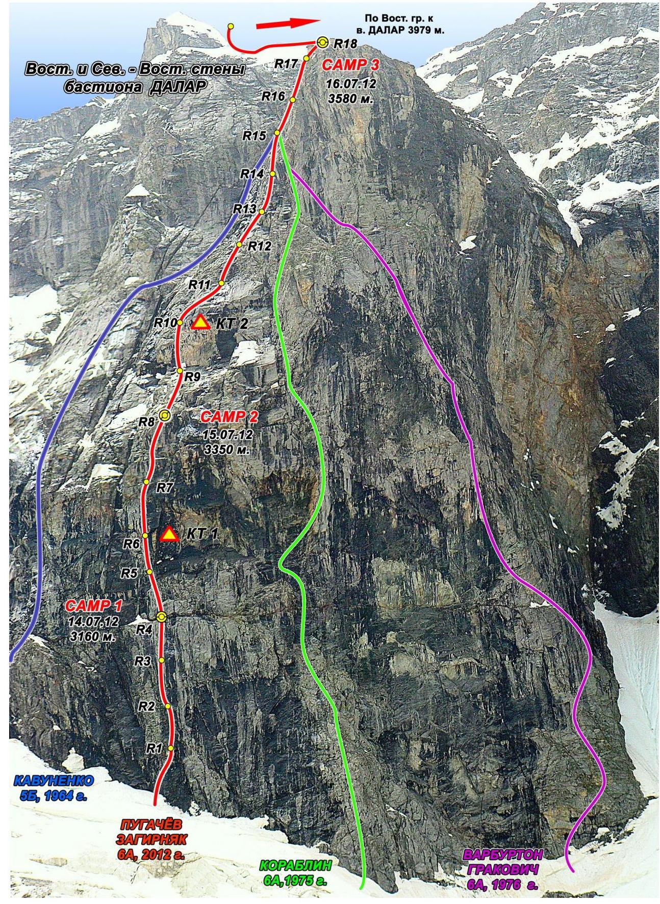
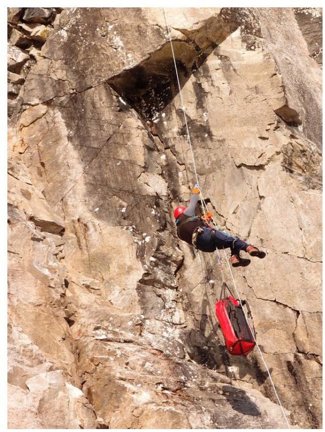
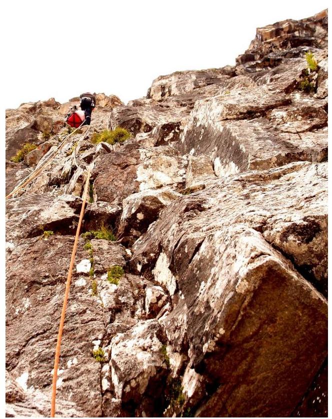
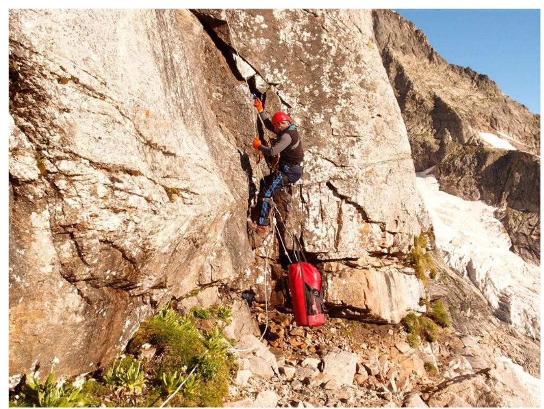
Photo 6. Technical photo of the route to peak Dalar (3979 m) along the center of the north-eastern wall of the bastion
Time schedule of the ascent
Route Description by Sections
General Characteristics
The north-eastern 600-meter wall of the Dalar bastion is characterized by complex rock work throughout. The wall has a large steepness and length of sections of slabs and "ram's foreheads".
On the route to the left, there are drainage grooves and couloirs, forcing a change in direction. In the lower part of the route, there is a large number of wet areas, where movement is complicated by the presence of grass. The route involves significant use of ITO and requires high psychological tension.
Overall, the route is quite monolithic. A short section of destroyed rocks above the first overnight stay is thoroughly cleaned by climbers (processed from the bivouac).
Water is available in several places. It is enough to take only a daily supply.
Route stations (up to R10, further organization of stations on their own points) are equipped with D10×40 mm bolts. Intermediate bolts are predominantly D8×22 mm.
Approach to the Route
From the overnight stay on the left-bank moraine of the Kichkinokol glacier, ascend by snow to the plateau of the Big Kichkinokol glacier. Move along the plateau to the left part of the north wall of the bastion. Pass 60 m above the ridge - the counterfort separating the eastern wall of the bastion from its northern part, along which the Koroblin route, 6A, passes.
The starting point of the route is marked by a non-obvious internal angle, located to the right of the large cam-couloir, 60 m to the right of the counterfort of the m-ta Kavunenko, 5B. At this point, the snow is maximally adjacent to the rocks (in the second half of the season, a rantkluft is possible). From the initial bivouac - 1.5 hours.
General Route Description
R0–R2 and inclined slabs between them.
R2–R3 along overhanging walls, and a short pendulum to the left, bypassing the overhangs.
Rocks like "ram's foreheads", complicated by:
- R3–R4 short vertical walls,
- grass and mosses.
Exit to a horizontal ledge. Overnight stay is possible.
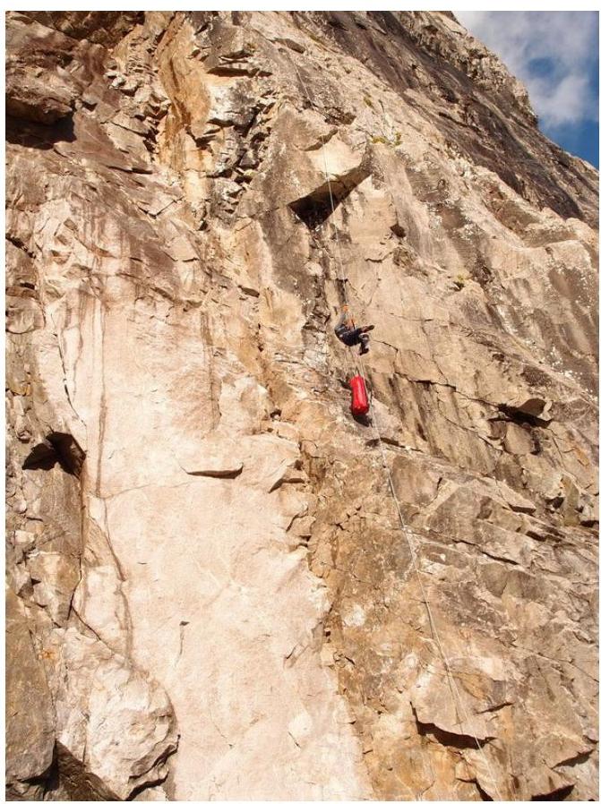
Further movement upward along a vertical slab - a chimney, R4–R5, turning into a system of vertical slots along black chimneys - slabs to the right.
R5–R6 Overhanging crack, turning into a vertical slab.
Control Tour 1
R6–R7 Up - to the right along overhanging slabs (ITO, scyhooks). Then crossing inclined slabs to the left to a non-obvious rib along the right part of the couloir. Further to the right along inclined slabs:
- Long 9 m traverse along an inclined slab
- Vertical exit to the right
Not difficult climbing along inclined slabs to the second overnight stay along the rib of the right part of the couloir.
Not difficult climbing along inclined slabs to a large cornice. Passing the cornice (ITO on anchors and top hammers 10 m), R9–R10.
Further:
- Hole scyhooks and bolts (12 m)
- Crossing the cornice to the right-up
- Climbing 10 m from the last bolt.
Control Tour 2
R10 - Movement of the first to the left to the angle. Then along the slabs to the right to R11 groove and inclined slabs.
A series of small alternating slabs and small cornices, going to the left. Exit to a narrow ledge, not allowing R11 - installation of a tent, but suitable for a sitting overnight stay R14 (next overnight stay is possible at the base of the snow "knife").
Further path - 240 m to the base of the snow "knife" R14 - goes along steep walls with narrow ledges, compressed by R18 rock cornices (ITO). Exit from the wall to a ledge under the snow "knife" is complicated by:
- small stones on the slabs,
- running water,
- in the morning - rime ice!
On the ledge, you can organize a bivouac. Through the "knife" exit to the eastern ridge of Dalar (see the route "Dalar along the eastern wall of the bastion"). Further ascent coincides with the route "Dalar along the eastern ridge", and the exit to the summit tower - with the route "Dalar along the north-eastern wall of the eastern shoulder".
Descent from the summit is standard for all routes of the north-eastern bastion.
Recommendations to Climbers
The route is recommended for well-prepared groups with experience in several ascents of 6B cat. diff. The group must have a full set of mountaineering equipment. The presence of relief and dural scyhooks is mandatory.
Removable bolts were not used. On the route, climbers made two convenient overnight stays. Several more sitting overnight stays can be easily arranged if necessary, so hammocks on the route are not needed.
After the first and second overnight stays, it is advisable to process the subsequent sections.
In areas R6–R7 and R9–R10, it is recommended:
- to straighten the belays for subsequent movement or intermediate points for subsequent work;
- to pull the load for "twos" groups due to the high steepness on the cornices. The presence of stationary and intermediate bolts on the sections and stations allows this.
In areas R7–R8 and R10–R11, due to the proximity to couloirs (grooves), there is a probability of falling stones.
It is not recommended to overnight stay after exiting to the ridge in thunderstorm weather.
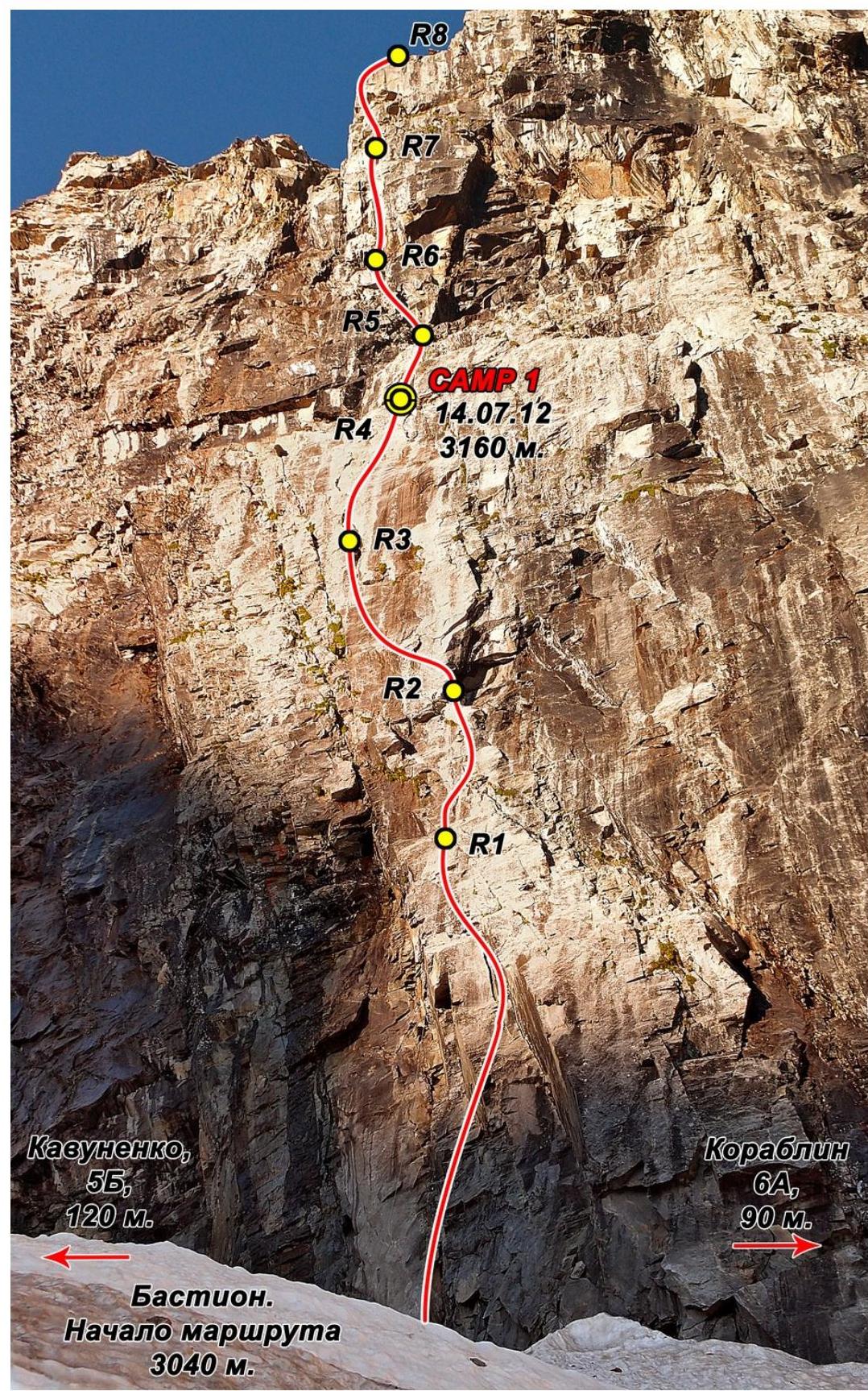
Bastion. Start of the route R0–R7
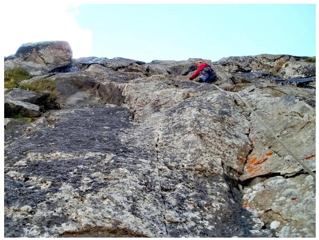
Start. Belays R0–R1 (S. Pugachev)
Start. Belays R0–R2 (M. Zagirnyak)
Belays R1 (M. Zagirnyak)
Belays on R3–R4
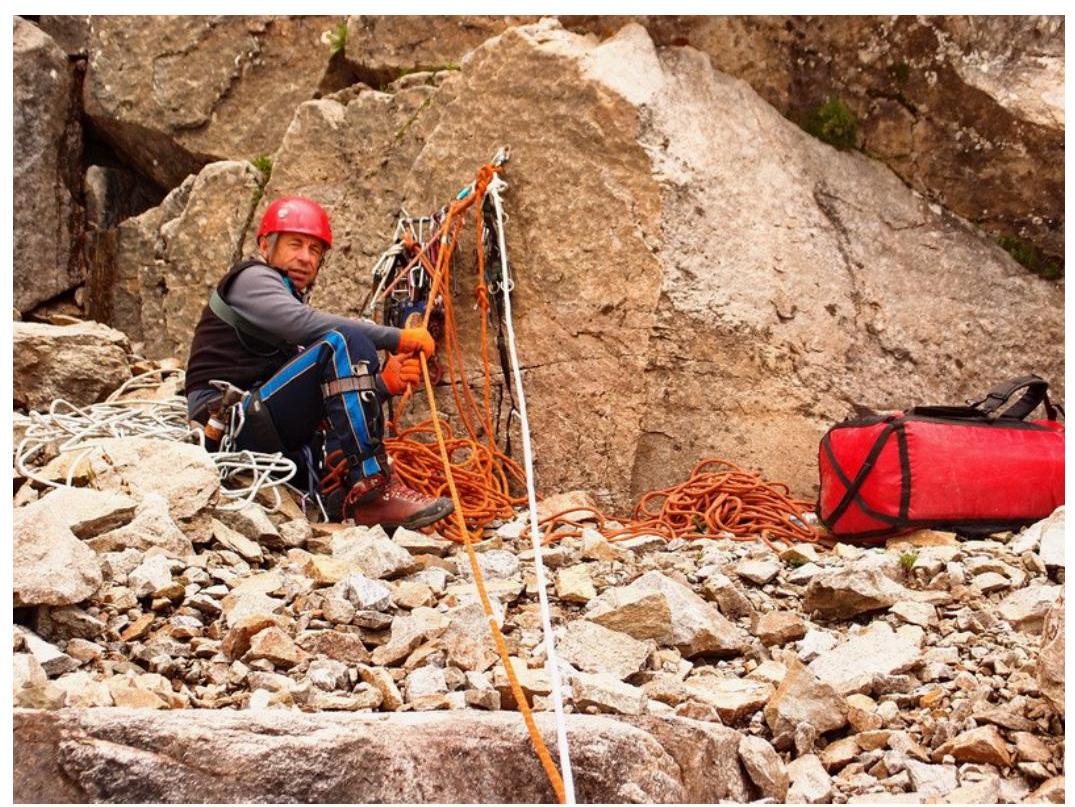
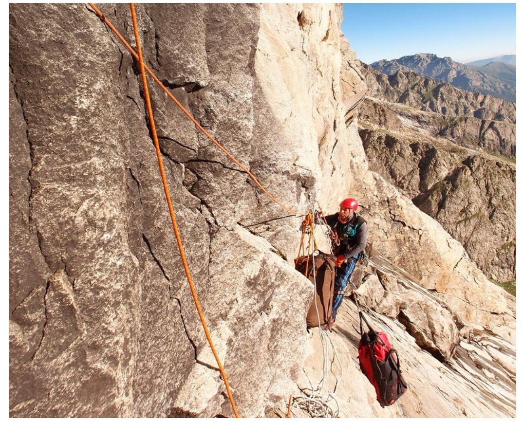
Station R4. Ledge-overnight stay (M. Zagirnyak)
Section R5. After the first overnight stay (M. Zagirnyak)
Sections R5–R7
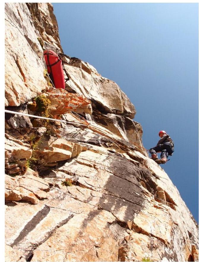
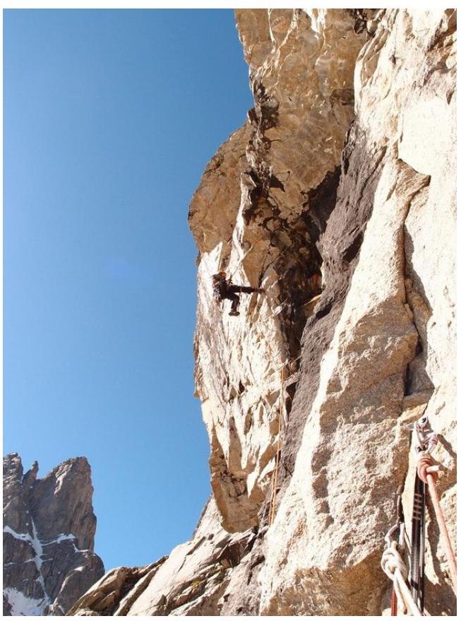
Overhanging slabs on R7 (M. Zagirnyak)
Section R6–R7. Belays through the cornice (M. Zagirnyak)
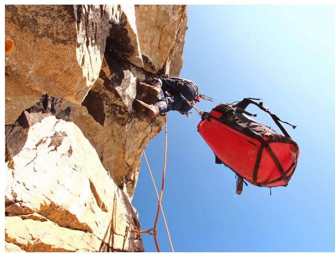
Station R9 and start of section R10 (M. Zagirnyak)
Section R10 (S. Pugachev)
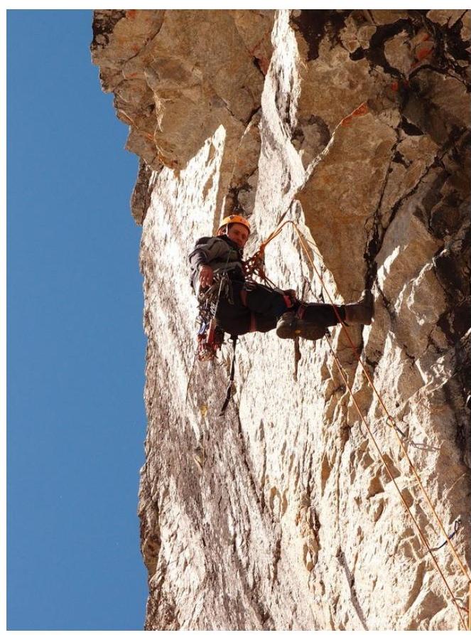
Section R10. Before the cornice (S. Pugachev)
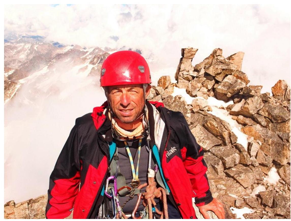
At the summit (M. Zagirnyak)
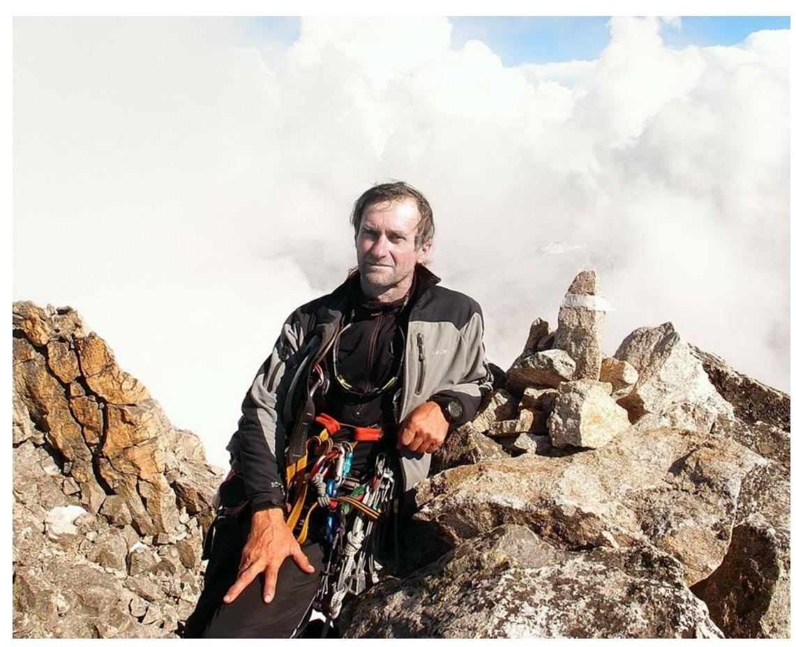
At the control tour on the summit (S. Pugachev)
Note from the Summit
Stavropol Regional Federation of Mountaineering Championship of Stavropol Territory - 2011 Date: August 10, 2011 Time: 14:30 Peak: Echar Route: 56 Centrula K.tr.
Composition:
- leader
- participants
- Ebozenol Ts.A.
- Ogabuy Ts.B.
- Kononenko O. 2
Note of the group SKFA from August 8, 2011 removed. Weather conditions OTHNE.
Protocol
Discussion on the first ascent of the route to v. Dalar (3979 m) along the center of the north-eastern wall of the bastion (proposed 6A cat. diff.), made by the team of the Poltava Regional Federation of Mountaineering and Rock Climbing from July 12 to 17, 2012.
July 21, 2012.
Present:
- Yu. Artsishevsky - releasing, head of the training department AUSB "Uzunkol"
- M. Zagirnyak - team coach, participant of the ascent
- S. Pugachev - leader of the ascent.
Speakers:
S. Pugachev:
The idea of making a new route arose back in 2010. Then, reconnaissance was carried out, and the route was viewed and options for its passage were considered. The line of the route is logical and absolutely independent. Along the route, maximum binding to the relief was carried out, which led to minor deviations from the classical direttissima of the north-eastern wall of the bastion. With the exception of the last sections, the route goes along monolithic vertical slabs and internal corners.
The route is unambiguous, starting to the right of the characteristic niche in the lower part of the wall.
Key places on the route:
- significantly surpass similar places on the neighboring Kavunenko route;
- are not inferior to the key sections of the neighboring Koroblin route.
The sections require a full set of equipment: anchor and petal pitons; "top hammers"; slings.
The level of free climbing 6A-6B is mandatory. The route can be recommended only for groups with experience in several ascents of 6th cat. diff.
Features of the passage:
- the presence of a platform is not mandatory; overnight stays on ledges are possible;
- water is available on the route;
- the presence of stations with stationary bolt pitons facilitates the passage of the route, increases its safety, and provides various tactical options for its passage.
M. Zagirnyak:
The route is unambiguous, starting from a characteristic place and going straight up along the direttissima to the exit to a characteristic ledge visible from under the route.
Key places are more complex than on our route to v. Kirpich, which we climbed in 2006, i.e., the difficulty of the route is quite high.
On the route:
- two control tours are left
- bolt stations are equipped
Passage of the route requires high rock climbing skills and the ability to use the entire arsenal of ITO techniques.
There are no special remarks to the partner.
The route should be classified as 6A.
Yu. Artsishevsky:
What is the complexity of the route compared to the 6A category routes you have previously climbed and neighboring routes?
M. Zagirnyak: As S. Pugachev said, the new route surpasses standard Caucasian 6B routes. All ropes up to the exit under the bastion tower are complex and require intense passage. The route is combined, and, naturally, additional equipment is required for passing the snow "knife" (crampons, ice axe).
As for the complexity compared to neighboring routes, we can say the following:
- We relatively recently climbed the Kavunenko route (2007) and the Koroblin route (2009) and believe that our route is undoubtedly more complex.
- As for the Slusar route (2004), as we have already written in the journal "Rиск", its classification raises doubts, and we are ready to present relevant materials if requested by the classification commissions of FALS of Ukraine or FAR.
Yu. Artsishevsky:
How was safety ensured on the route? S. Pugachev:
The team had all modern means to ensure safety, and the movement of each participant was on two ropes. We expected danger from falling stones along the internal corners. This danger was in the expected degree, but we moved carefully, and the last one cleaned the route for subsequent climbers.
Yu. Artsishevsky:
We knew about the team's intentions to make a new route. We observed the reconnaissance of the route. The area needs new routes, as many routes have become objectively dangerous due to the sharp melting of snow and ice.
Judging by the presented materials, the route corresponds to 6A cat. diff., and we will support the team in its classification at this level.
There are no claims or special remarks to the team members. The team worked in harmony.
The ascent is considered accomplished. Present materials to the classification commissions of the mountaineering federations of Ukraine and the Russian Federation.
Releasing Yu. Artsishevsky


