Ascent Logbook
- Technical Climbing Category.
- Climbing Area: Caucasus, Kichkinekol Valley.
- Route: Dalar — Zamok, traverse along the Northern wall of the bastion (Warburton).
- Difficulty Category: 6B category.
- Height Difference: 1030 m.
- Bastion height difference – 500 m.
- Route length – over 3 km.
- Length of sections with 5th category difficulty – 665 m.
- Length of sections with 6th category difficulty – 155 m.
- Average steepness of the bastion – 77°.
- Average steepness of the most difficult part of the bastion (200 m) – 81°.
- Pitons used: rock 112/0, chock stones 89/0, ice 2/0, bolt 4/0.
- Team's total climbing hours: 59 hours / 5 days.
- Overnight stays:
- On the bastion on a ledge, uncomfortable, three in a tent, one on a ledge separately.
- On the ridge, comfortable, lying down.
- On the ridge, comfortable, lying down.
- On the ridge, comfortable, lying down.
- Team Leader: Ivanov Vitaly Valentinovich, Candidate Master of Sports, Republic of North Ossetia-Alania, Vladikavkaz, Shmulevich St. 16/6, apt. 98. Team Members: Afanasyev Igor Oleg-Slavyanovich, Master of Sports. Bondarenko Igor Olegovich, Candidate Master of Sports. Egorin Sergey Vladimirovich, Candidate Master of Sports.
- Coach: Korablin Boris Nikolaevich, Master of Sports, Honored Coach of the RSFSR.
- Start of the route: August 9, 1998. Dalar: August 10, 1998. Dvoynyshka Z. and V.: August 12, 1998. Zamok: August 13, 1998.
- North Ossetian Republican Search and Rescue Service of the Ministry of Emergency Situations of Russia.
362035, Republic of North Ossetia-Alania, Vladikavkaz, pr. Kosta 273, tel./fax: 74-41-03
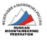
2900 m
General photo of Dalar peak. Taken on August 14, 1998.
- Route along the Northern wall of the bastion (Warburton) – 6A category.
- Route along the North-Eastern edge (Stepanov) – 5B category.
- Route along the North-Eastern wall of the bastion (Korablin) – 6A category.
Photo of the wall section of the route from the left
The route on Dalar peak along the Northern wall of the bastion (Warburton) is marked.
Drawn profile of the wall section of the route
1 cm – 40 m.
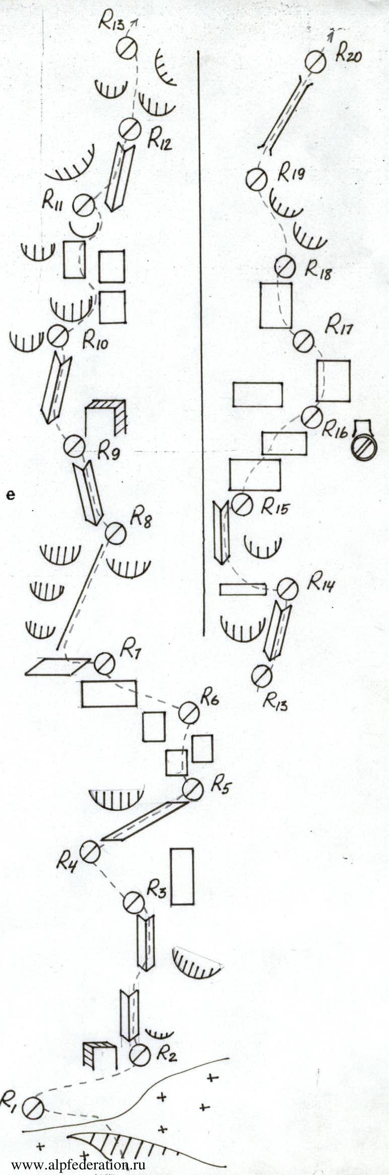
Route scheme. 1 cm – 20 m.
1 cm – 20 m.
Route description by sections
From the overnight stay, the approach to the route goes along the moraine and glacier. Before the start of the bastion wall, along a 30°, 200 m ice slope to the ranclyft (1.5–2 hours). Overcome the ranclyft and exit to the rocks at the beginning of the wall, height 2950 m.
Section R0–R5:
- Clearly visible
- Goes logically, without problematic areas
- Bypassing all overhangs to the right
- Rocks are dry, rough, 5.
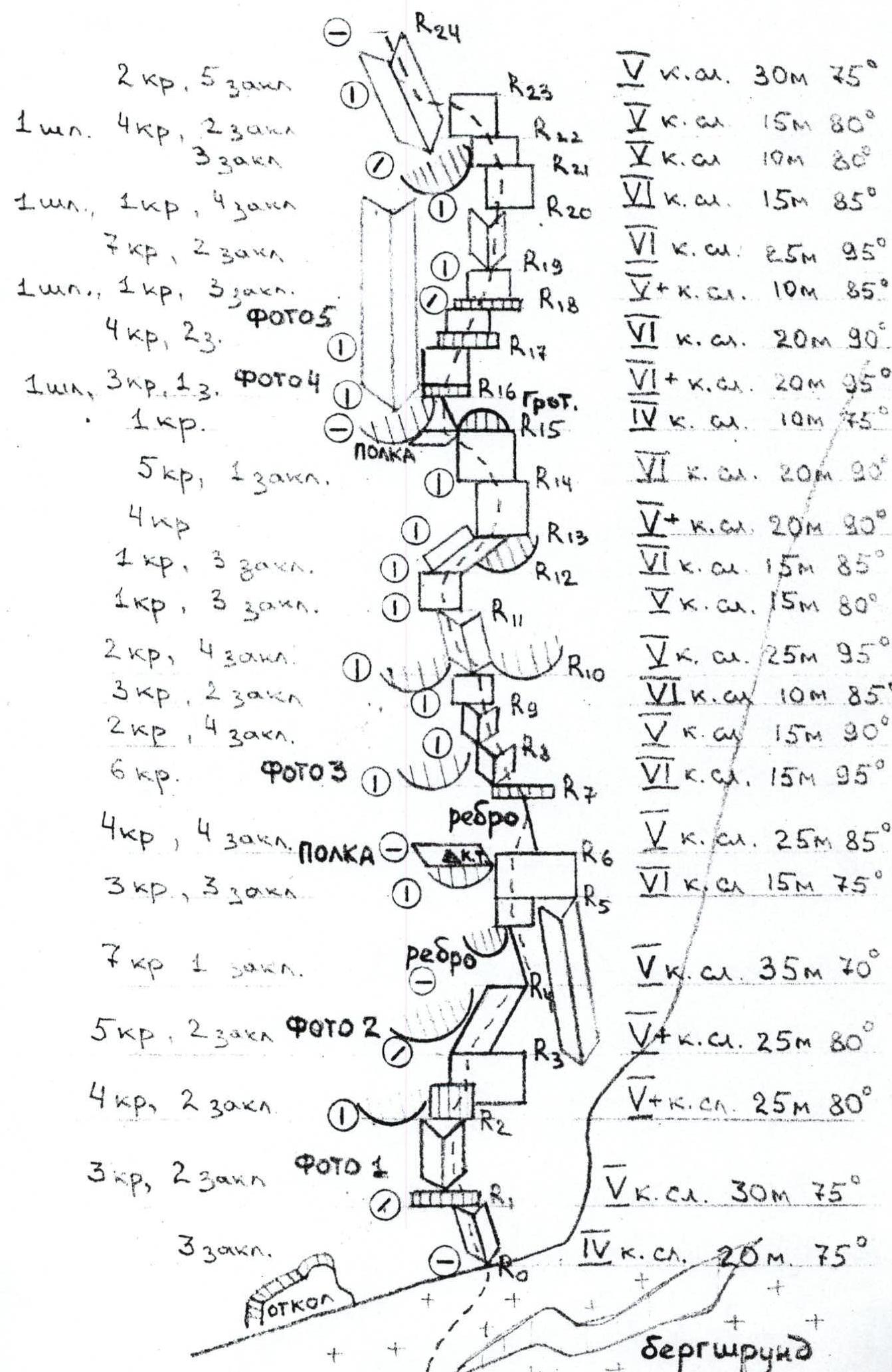
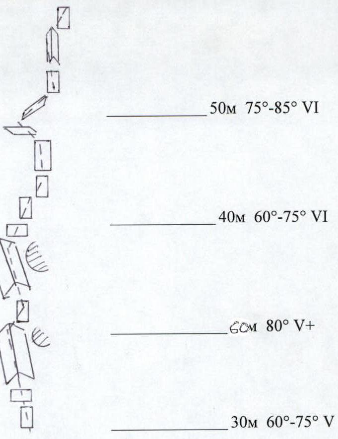
R5–R6. Smoothed wall without macro-relief 6, 15 m, 75°, passed by free climbing to a wide ledge, here is a control cairn. Overnight stay is possible.
R6–R11. With each subsequent rope, the steepness and complexity increase. The route mainly goes along:
- internal corners
- short walls 5–6.
The line of movement is not unambiguous and depends on the condition of the rocks and current streams.
R11–R15. A complex section going along wet rocks of the internal corner with a steepness of 80–95°, mainly 6, it is possible to use artificial climbing techniques (ACT). At the end of the section under an overhang – a grotto, overnight stay is possible.
R15–R16. From the grotto along a simple edge 4, 10 m, 75° to approach under the overhanging walls to the right of the large dark internal corner.
R16–R17. Through a cornice along a steep complex wall 6+, 20 m, 95°, exit under the next cornice. Here is a station hanging on two bolts.
R17–R18. Through the next cornice (observation of the partner is absent) along a sheer wall 6, 20 m, 90°, climb under the third cornice.
R18–R19. Overcome the cornice and along a wet wall 5+, 10 m, 85°, approach under the internal corner. Here is a convenient station on one bolt.
R19–R20. Along a steep complex internal corner 6, 25 m, 95°, climb under the overhanging walls to the right of the large wet cornice. Here is a station hanging on two bolts.
R20–R21. Along a complex wall (holds are small) 6, 15 m, 85°, exit to the bend of the wall, to the right of the black wet internal corner.
R21–R23. From here, climb a series of complex walls 5, 50 m, 80°, to a bolt under an overhanging wall.
R23–R24. From the bolt, organize a pendulum to the left through a stream into the internal corner, and along the smoothed rocks of the left part of the internal corner, exit to a convenient ledge.
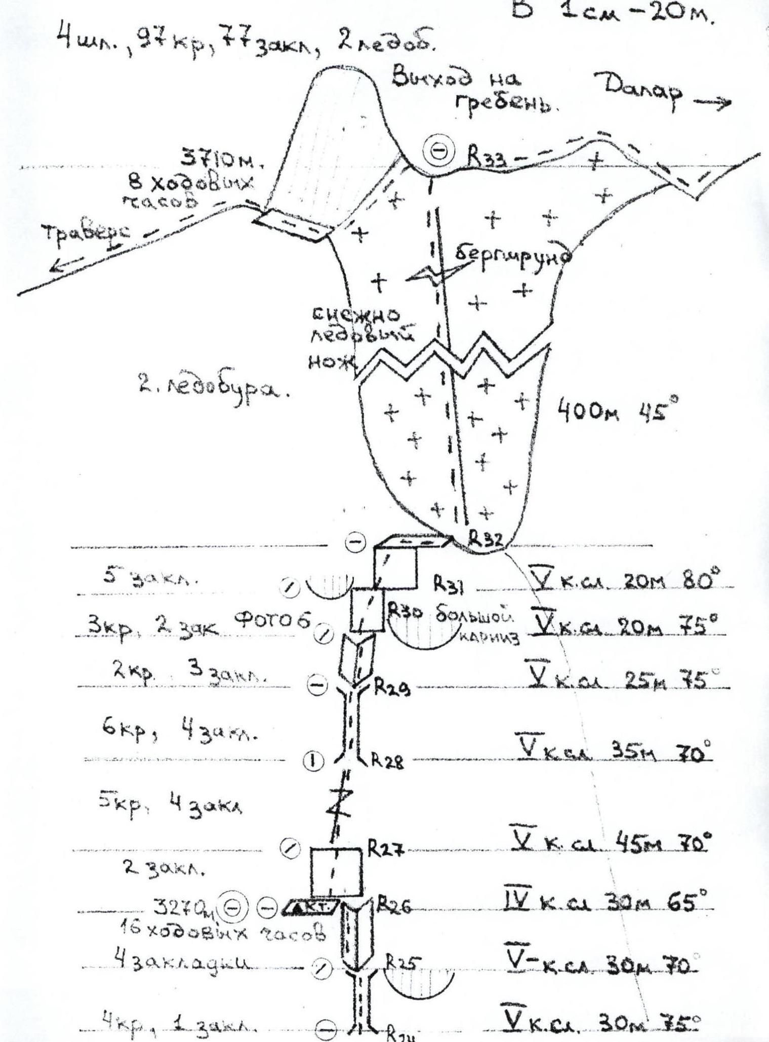
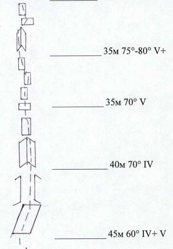
R24–R26. Further along the chimney and internal corner 5, 60 m, 70–75°, exit to a ledge. Here is a bivouac and a control cairn. 16 climbing hours from the start of the wall.
R26–R28. From the ledge along a not steep wall and a clearly defined gap 4–5, 75 m, 65–75°, approach under a large chimney.
R28–R29. Along the chimney 5, 35 m, 70°, with a wedged plug, exit to a fragment.
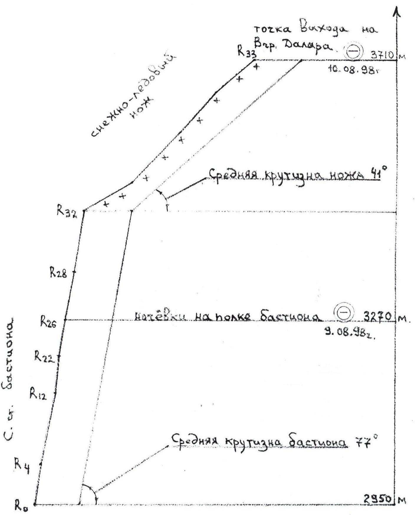
R29–R32. From the fragment, first along the internal corner, then along the wall 5, 65 m, 75–80°, exit to the top of the bastion. Here is a convenient area for rest, there is water.
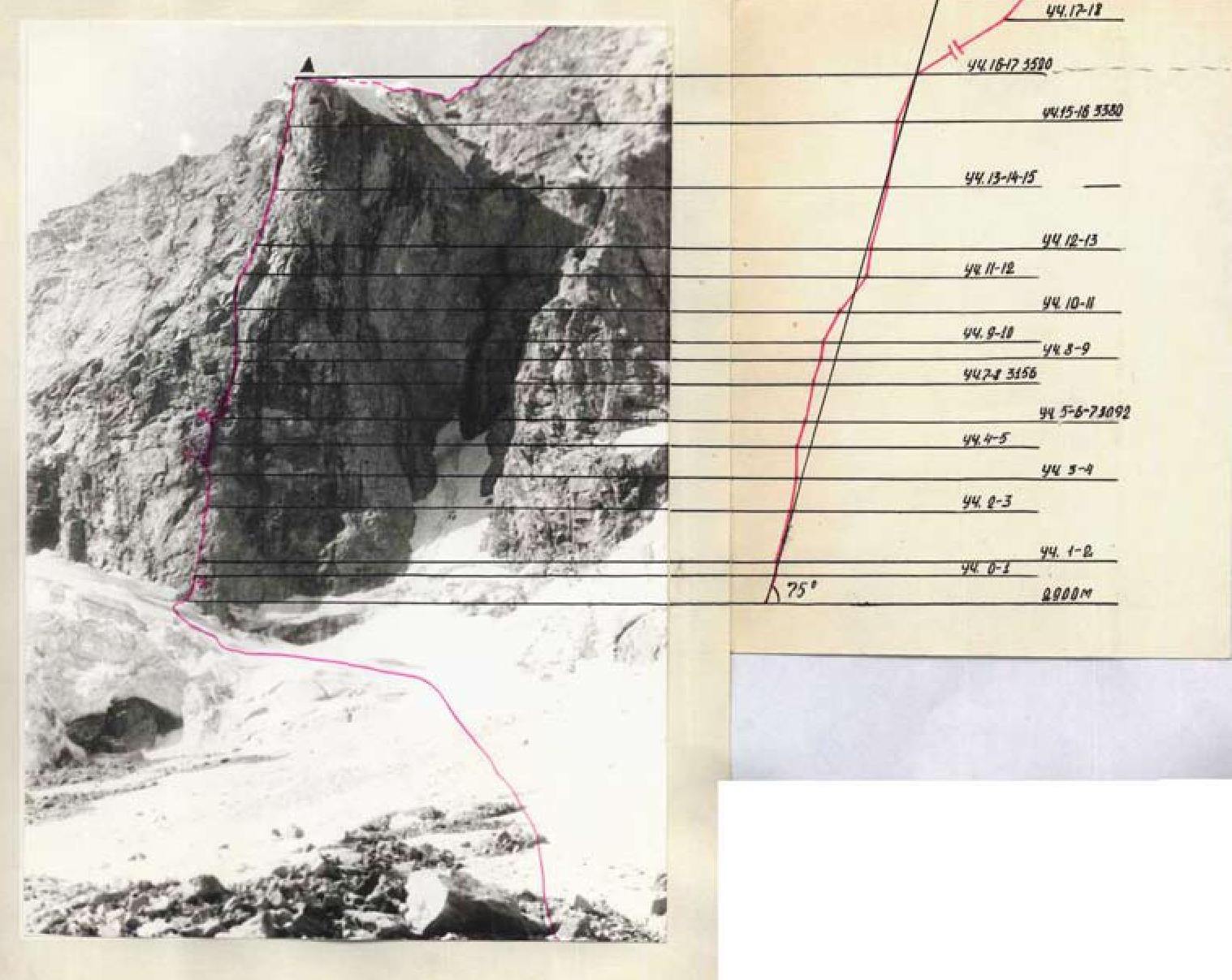
R32–R33. Along the left side of the "knife", then along the snow-ice edge 400 m, 45°, overcoming the bergschrund, exit to the traverse ridge. To the right is Dalar peak, to the left, the line of the route through Dvoynyshki peaks to Zamok is clearly visible.
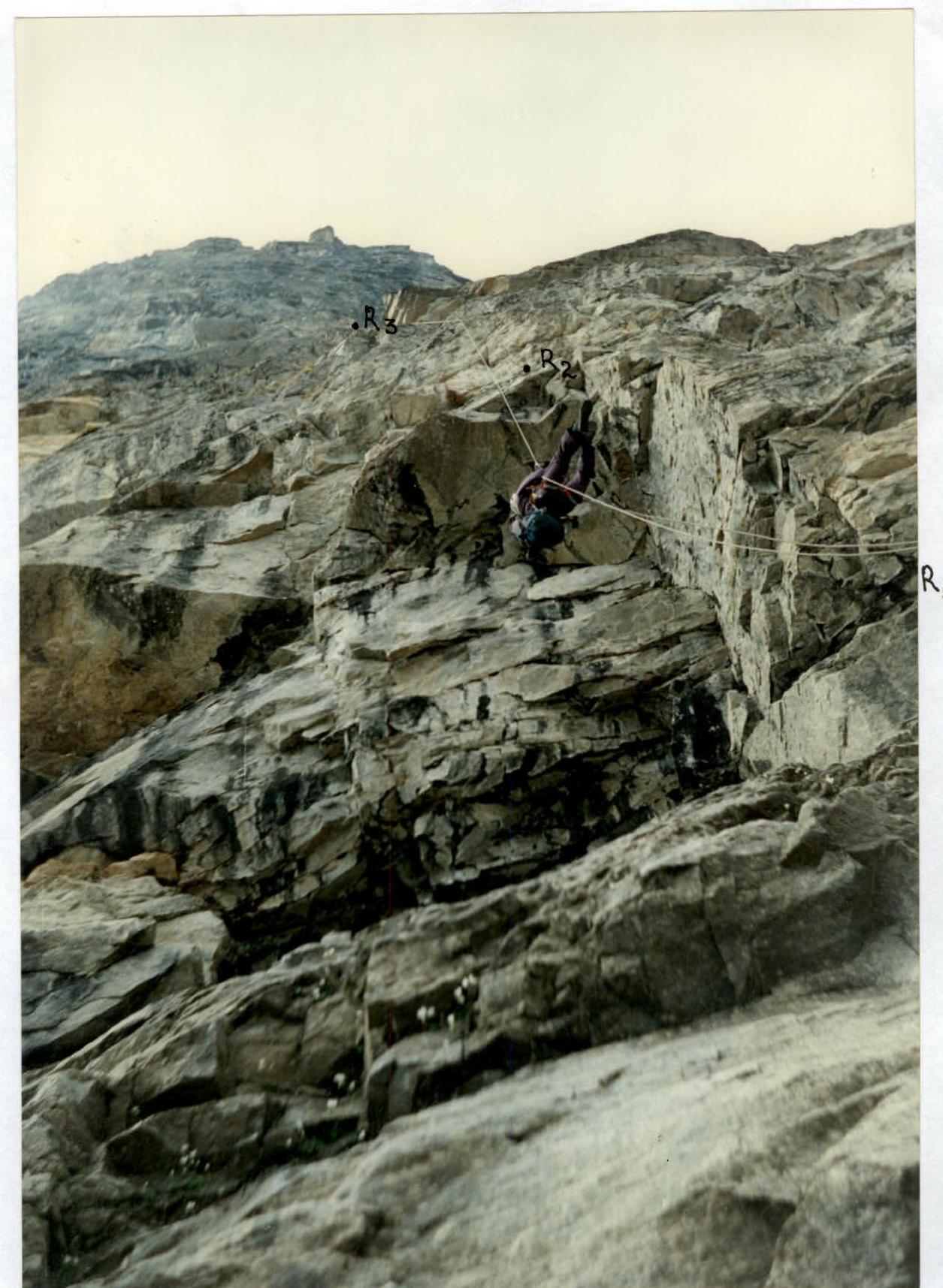
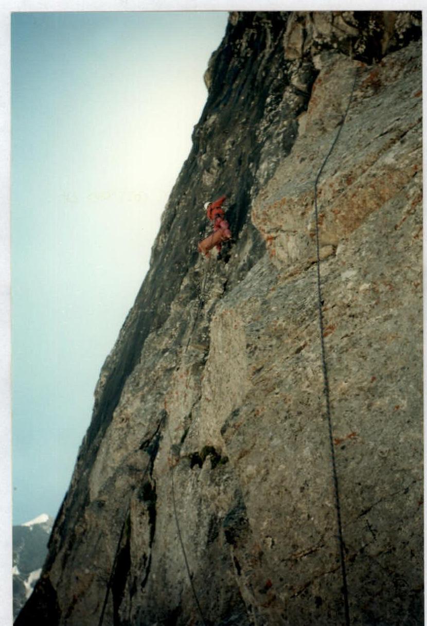
Photo #1. Passage along the fixed ropes of section R1–R3 (5+, 50 m, 80°).
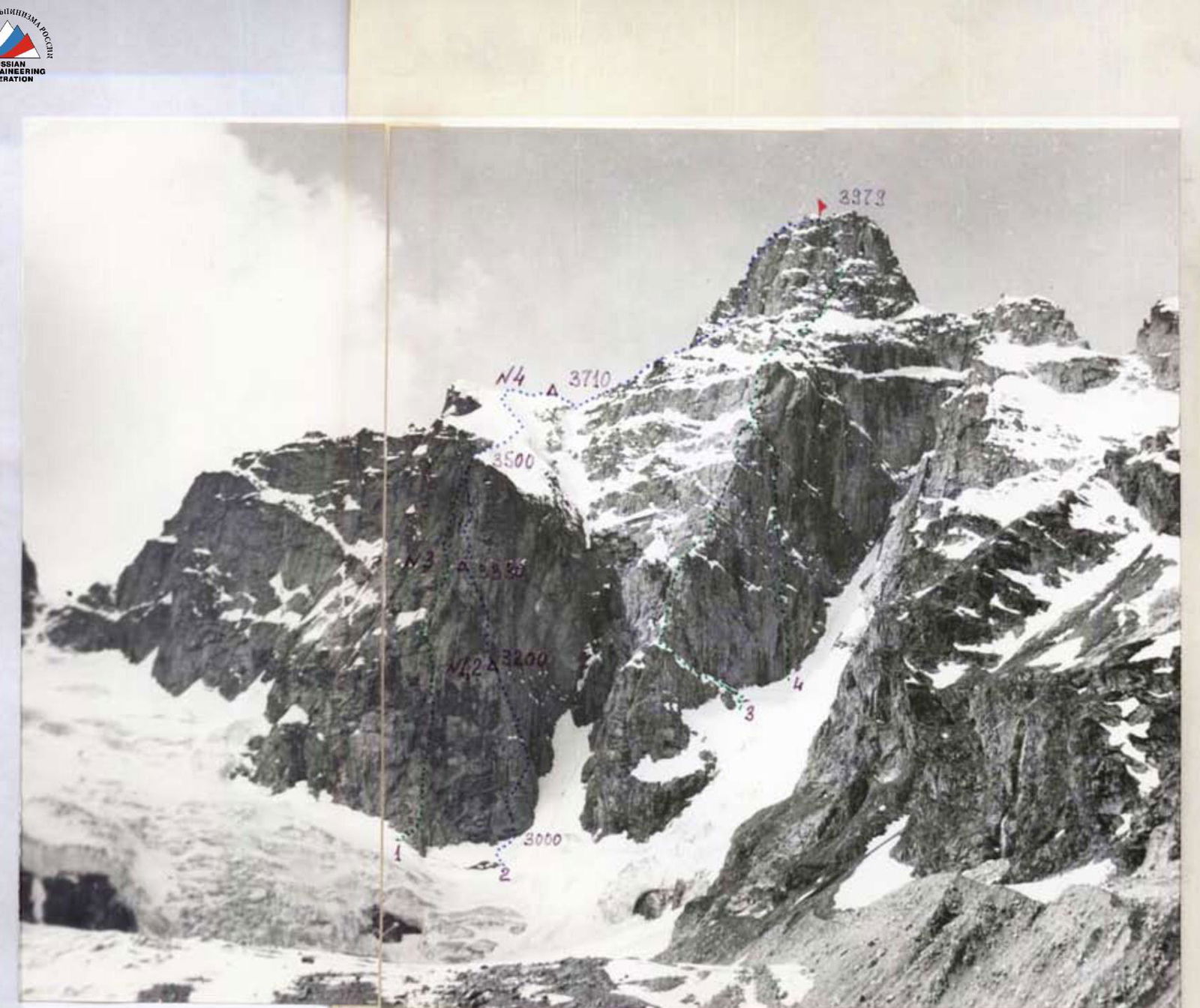
General photo of Dalar peak Taken from point #2 on June 13, 1983, at 11:15 with an "Industar-23" lens with a focal length of 110 mm. The height of the shooting point is about 2600 m, the distance from the wall is about 2000 m.
- Korablin's route along the NE wall of the bastion 5B category.
- Warburton's route along the N wall of the bastion 5B category.
- Stepanov's route along the NE edge 5B category.
- Snesarev's route along the N wall 5B category.
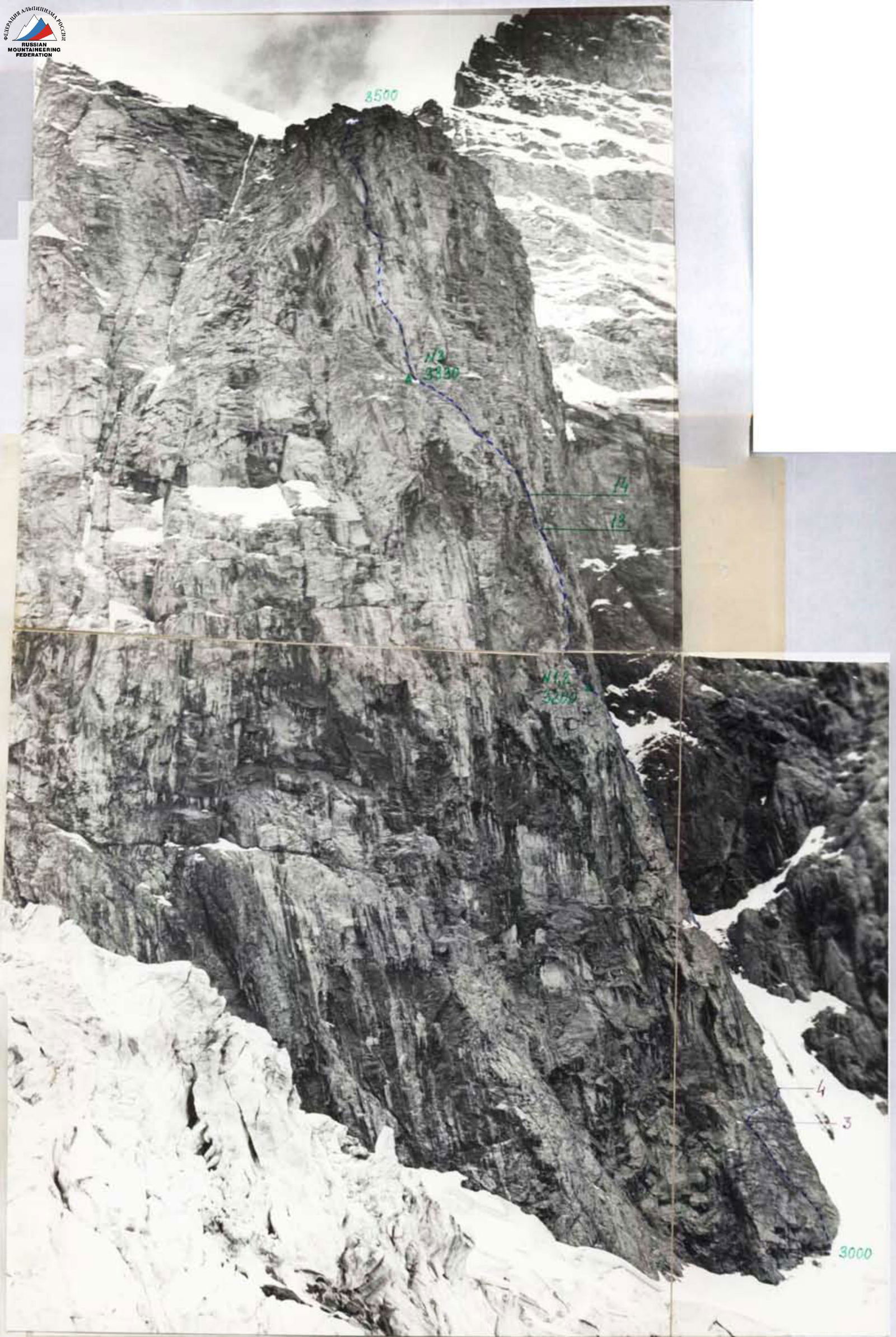
Photo of the wall profile from the left Taken from point #1 on June 13, 1983, at 13:00 with an "Industar-23" lens with a focal length of 110 mm. The height of the shooting point is about 3000 m, the distance from the wall is about 700 m.
Ascent Logbook
- Western Caucasus, Uzunkol valley
- Peak name: Dalar along the N wall of the bastion (Warburton's route).
- 6A category.
- Route type: combined
- Height difference: 1050 m
Route length: 1820 m, including:
- bastion – 785 m
- tower – 395 m
- sections with 5th category difficulty – 415 m
- sections with 6th category difficulty and ACT – 430 m Average steepness of the main part of the bastion route – 82°.
- Pitons left on the route: total – 8, including bolt – 1.
Pitons used on the route:
- stationary bolts – 7, including ACT – 3
- removable bolts – 2, including ACT – 1 Total ACT used – 107.
- Team's climbing hours: 34 hours and 4 days.
- Team Leader: Pucnin Vyacheslav Evgenievich – Candidate Master of Sports Team Members: Shavrovich Alexander Leonidovich – Master of Sports, Rylov Nikolai Valerievich – Candidate Master of Sports
- Coach: independently
- Start of the route: 7:30, August 16, 2000. Reached the summit – 13:00, August 19, 2000. Returned to base camp – 12:00, August 20, 2000.
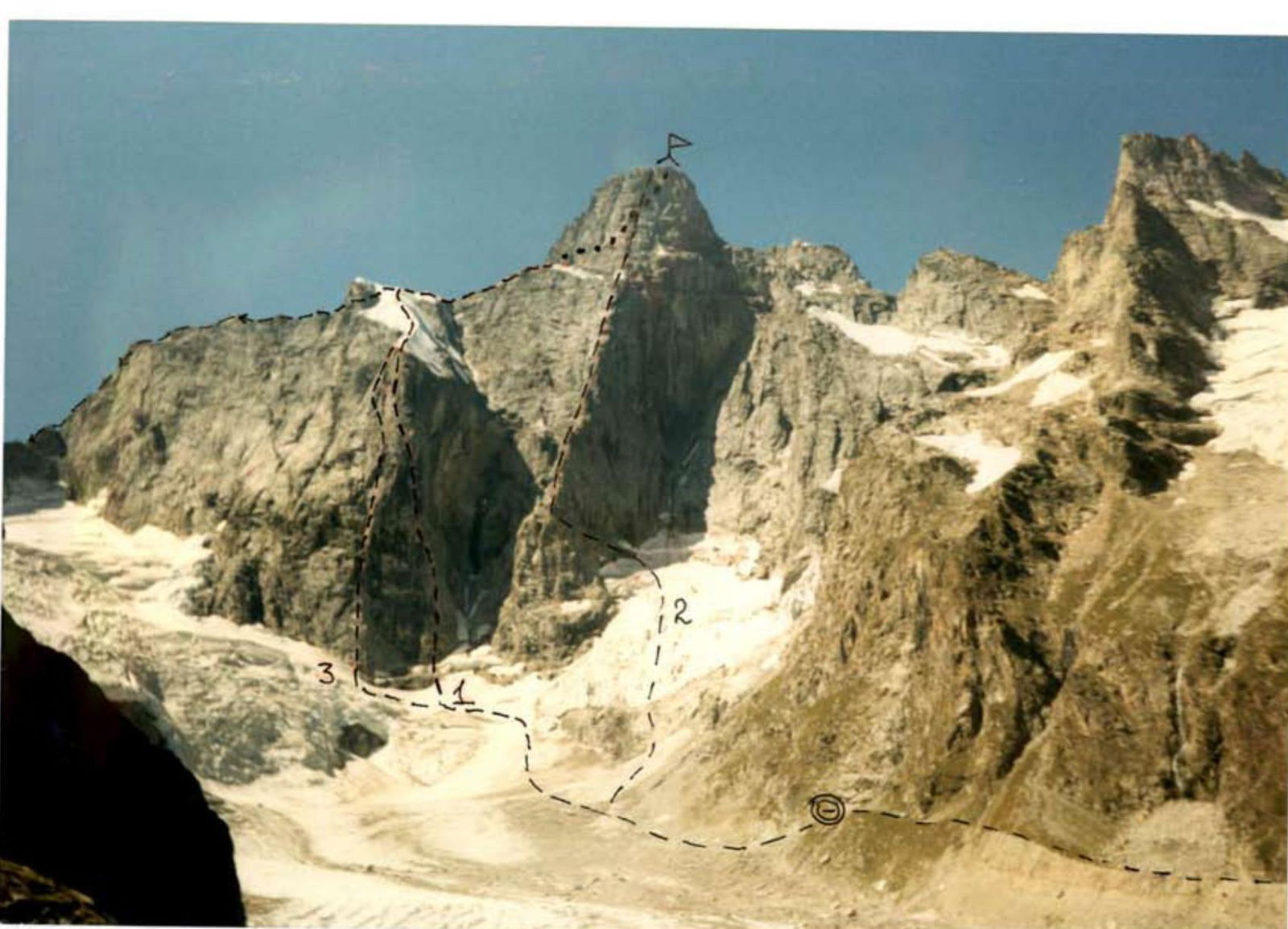
In the photo – bastion on Dalar peak #1 – Korablin's route, 1975, 6A category, NE wall of the bastion #2 – Warburton's route, 1976, 6A category, N wall of the bastion UIAA scheme. Warburton's route on Dalar peak along the N wall of the bastion 6A category.
2nd day, 9:00–17:00 8 climbing hours, 120 m until 11:00 – thick fog, after 17:00 – thunderstorm, hail 1st day, 8:00–19:00, 11 climbing hours, 310 m since 18:00 – thick fog
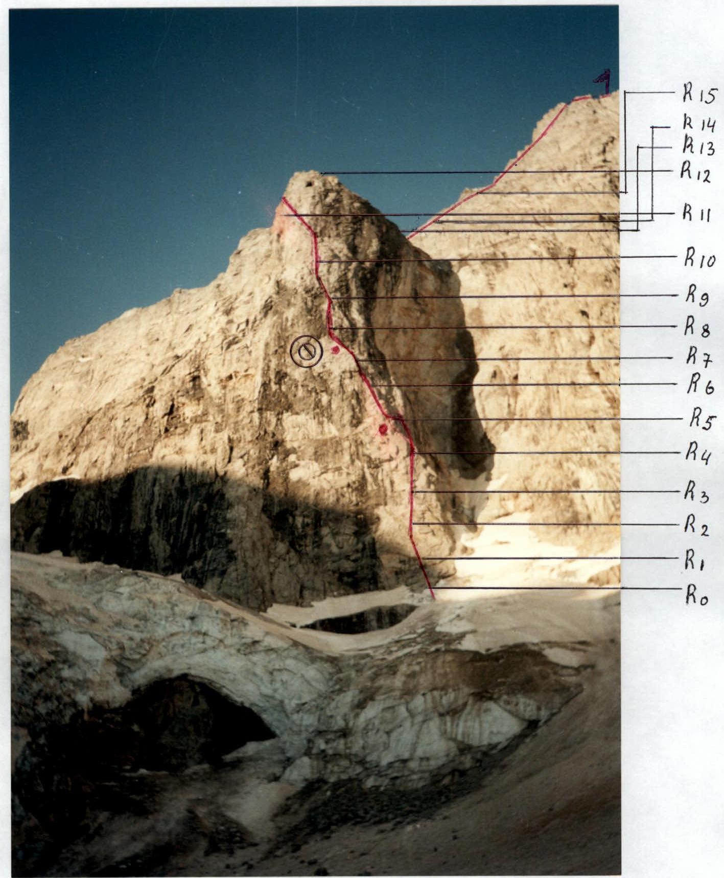
| Section | M | Category | Steepness |
|---|---|---|---|
| R14 | 50 | 6 A2 | 85° |
| R13 | 40 | 6 A1 | 80° |
| R12 | 45 | 6 A1 | 90° |
| 15 | 6 A1 | 90° | |
| R11 | 20 | 5 | 90° |
| R10 | 40 | 6 A2 | 90° |
| R9 | 40 | 6 A2–A3 | 95° |
| R8 | 35 | 6 A2–A4 | 90° |
| R7 | 40 | 6 A1–A3 | 95° |
| R6 | 20 | 5 | 80° |
| R5 | 35 | 5 | 80° |
| R4 | 40 | 6 | 80° |
| R3 | 40 | 5+ | 80° |
| R2 | 20 | 4+ | traverse |
| R1 | 40 | 4 | 50° |
| R0 | 400 | 2–3 | up to 40° |
3rd day, 8:30–19:30 11 climbing hours, 305 m since 18:00 fog
| Section | M | Category | Steepness |
|---|---|---|---|
| R26 | 40 | 5 | 75° |
| R25 | 40 | 5 | 70° |
| R24 | 80 | 4 | 55° |
| R23 | 300 | 2–2 | ridge |
| R22 | 350 | 4 | 35–50° |
| R21 | 50 | 4 | 55° |
| R20 | 35 | 5 | 60° |
| R19 | 35 | 4+ | 65° |
| R18 | 40 | 6 A1 | 85° |
| R17 | 30 | 5 | 65° |
| R16 | 40 | 5 | 60° |
| R15 | 35 | 4+ | 65° |
| R14 | 50 | 6 A2 | 85° |

4th day, 8:00–13:00 – 5 climbing hours
| Section | M | Category | Steepness |
|---|---|---|---|
| R30 | 150 | 3 | ridge |
| R29 | 20 | 5 | 80° |
| R28 | 45 | 6 A1 | 85° |
| R27 | 20 | 5 | 75° |
Description of the route by sections
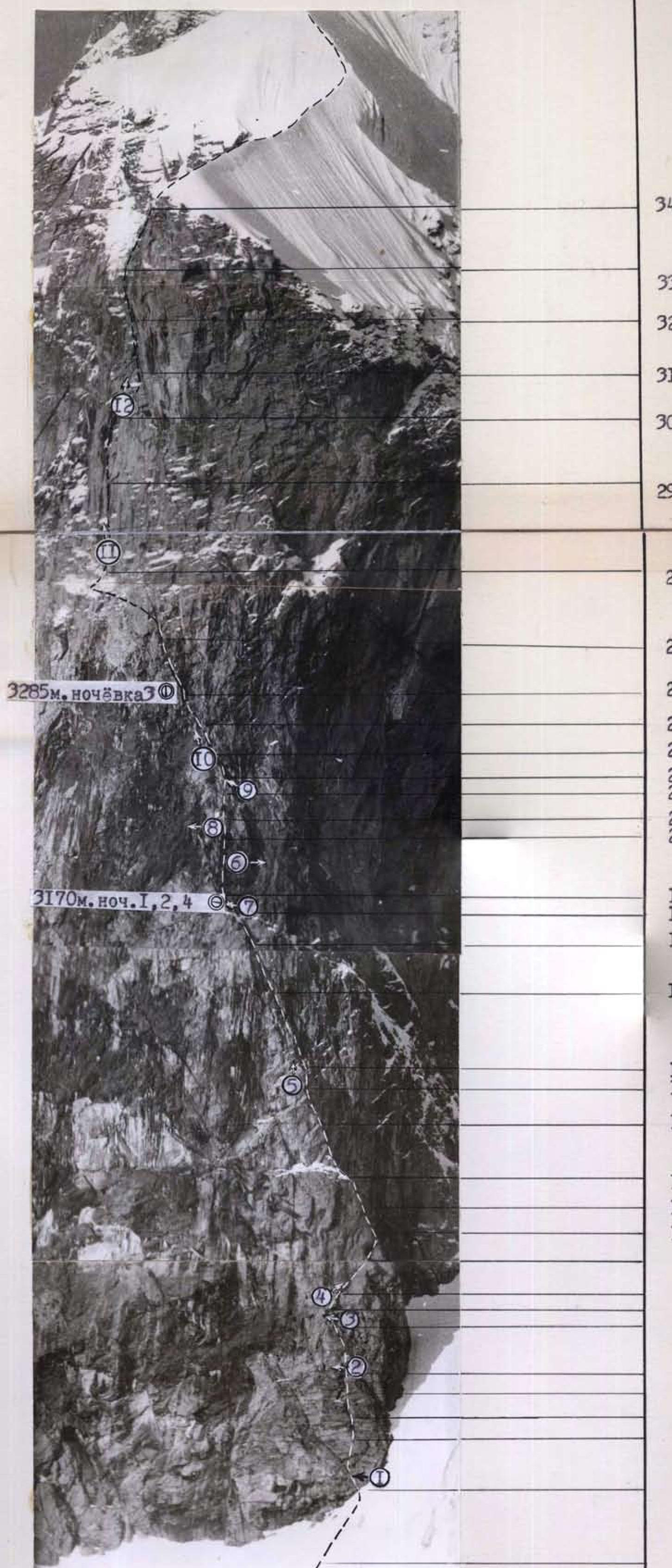
The approach to the route leads along a 50-meter 30° firn slope (R0–R1). The steepness of the slope increases as you approach the bastion, reaching 45° at its base. The route starts with a characteristic grass-covered crack on a 30-meter wall (R1–R2), then an internal corner (R2–R3) leads to a convenient ledge for belaying (R2). Further along a steep wall (R3–R4) and internal corner (R4–R5) under a 30-meter wall (R5–R6), which ends with an overhang (R6–R7). When the relief starts to overhang, move right for 3–4 m, then left-up. Having passed the wall (R7–R8), we exit to fragment R3. From here, right-up along the wall with a small number of holds (R8–R9) goes on friction; in the middle part of the wall, an old bolt is hammered. Further along the destroyed internal corner (R9–R10) and wall (R10–R11), the exit to R4. After a 10-meter wall (R11–R12), there is a convenient ledge for overnight stay, on which is R1 control cairn. This ledge goes to the left, bypassing most of the northern wall of the bastion. Along it, if necessary, you can transfer to the routes of Ivashchenko and Korablin. Then up along the edge (R12–R13), leaving the black overhanging rocks to the right, which break off to the glacier. Exit to an inconvenient belay point R5. Belay, hanging in a "harness". Along the internal corner (R13–R14) up under the overhang. The upper part of the angular surface is located on its right side. A small rock cornice (R14–R15) can be passed using small-sized chock stones for ACT and "heavenly" pitons. After R6, small cornices alternate with walls. Everything goes by free climbing (R15–R16). The wall (R16–R17) is passed using ACT. As ACT, chock stones of medium size are used. Section R17–R18 leads to R2 control cairn in a snow-filled niche – a convenient place for overnight stay, protected from bad weather (R8). Along an inclined slab (water flows) – exit under a sheer wall (R19–R20). Further up-right (but not left!) towards a small fragment, organize a convenient belay point R9 (if necessary – a sitting bivouac). From here up along the wall (R20–R21 and R21–R22). Further along the internal corner (R22–R23), the exit under an overhang, then to the left along an inclined ledge to R10. Here you can organize a sitting overnight stay. Sections R19–R22 – one of the most difficult places on the route. Sections R23–R26 represent a series of internal corners passing into each other. In the morning hours, the rocks are covered with rime ice. In the second half of the day, water already flows. On the right side of the internal corner (R23–R24), an old American bolt is hammered. From R11 up along a slab with a crack, resembling a narrow chimney, to R12.
Section R27–R28 is not technically difficult – a wide inclined ledge leading to R3 control cairn and R13. A place convenient for overnight stay. If necessary, you can transfer from here to Korablin's route. Further right-up along the right side of the internal corner on a small ledge R13. Further up along the internal corner (R29–R30), which ends with an overhang. From here up-right along a not clearly expressed internal corner (R30–R31). Rime ice. In the middle part of the corner, an old American bolt. Further along an inclined chimney up to R16. The rocks of the chimney are destroyed, covered with ice, the structure of the rocks is "tile-like". From R16 up along the internal corner towards a wide inclined ledge (R33–R34), which leads to a snow "knife" (R34–R35). There are many loose stones on the ledge. The snow "knife" is a 45° snow slope leading to the eastern ridge of Dalar peak. Along the ridge (R35–R37) under the base of the summit tower. At any point on the ridge, you can organize a convenient overnight stay. The summit tower begins with a 30-meter wall (R37–R38). Further right-up, crossing the ridge to R21. Along the internal corner (R39–R40) and wall (R40–R41), the exit to Warburton's wall (R41–R42) with a wide fragment in the upper third. After the wall, a not difficult ridge leads to the summit.
Ascent Logbook
- Climbing area – Western Caucasus, Uzunkol valley, section number in the classification table – 2.3
- Peak name – Dalar, route name – along the Northern wall of the bastion
- Proposed category – 6A
- Route type – combined
- Height difference – 889 m Route length – 1290 m. Length of sections with 5th category difficulty – 385 m, 6th category – 345 m. Average steepness: main part of the route – 65°, entire route – 60°.
- Pitons left on the route: total – ...; including bolt ... Pitons used: stationary bolts – 2, including ACT – ...; removable bolts – ..., including ACT. Total ACT used – 4.
- Team's climbing hours – 22 hours, 3 days.
- Team Leader: Dzaparidze Yu.O. – Master of Sports. Team Members: Vinokurov A.F. – Master of Sports, Pivikov D.E. – 1st sports category, Khomchenko D.S. – 1st sports category.
- Coach: Dzaparidze Yu.O. – Master of Sports.
- Start of the route: 8:00, July 27, 2000.
Reached the summit – 14:10, July 29, 2000.
Returned to base camp – 14:30, July 30, 2000.
July 27, 1983, 10:30. Taken with a "Leningrad" lens, focal length 500 mm. From a distance of about three kilometers. Shooting point B1 on the map of the area. The height of the shooting point is 2500 m.
Technical photograph of the route

General photo of the peak
- Dalar along the E ridge 5A category (V. Kavunenko – 1964)
- Dalar along the NE wall 5B category (Yu. Porokhnya – 1978)
- Dalar along the E wall of the bastion 5B category (V. Kavunenko – 1964)
- Dalar along the NE wall of the bastion 6A category (B. Korablin – 1975)
- Dalar along the center of the bastion 6A category (A. Ivashchenko – 1982)
- Dalar along the N wall of the bastion 6A category (M. Warburton – 1976)
- Dalar along the NE edge 5B category (V. Stepanov – 1962)
- Dalar along the left part of the N wall 6A category (A. Snesarev – 1962)
- Dalar along the right part of the N wall 5B category (V. Shopin – 1975)
- Dalar along the NE wall of the northern shoulder 5B category (B. Korablin – 1969) Photo taken on July 26, 2000, from the moraine of the Big Kichkinekol glacier.
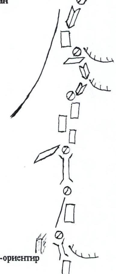
Route scheme
Pitons 3
R17 – 100 m, 50°, 3
Friends 3
Chock stones 3
R16 – 35 m, 75–80°, 5+
Chock stones 7
R15 – 35 m, 70°, 5
Chock stones 5
R14 – 40 m, 70°, 4
Rock pitons 4
Chock stones 4
R13 – 45 m, 60°, 4+, 5
R12 – 300 m, 45–50°, 3–4
Chock stones 8
Rock pitons 4
R11 – 50 m, 60–75°, 5+
Chock stones 6
Rock pitons 8
Friends 3
R10 – 60 m, 85–90°, 5+, 6; 15 m, 80°, 5+
Photo 4–5
Rock pitons 15
R9 – 7 m, 100°, 6 A4; 15 m, 95°, 6; 30 m, 90°, 6
Photo 3
Friends 2
Chock stones 5
Rock pitons 7
R8 – 40 m, 85–90°, 6
Friends 3
Chock stones 5
Rock pitons 5
R7 – 30 m, 70°, 5; 10 m, 90°, 6
Photo 2
Friends 3
Chock stones 10
R6 – 12 m, 30°, 6; 10 m, 95°, 6 A4; 15 m, 80°, 5+
Chock stones 8
Rock pitons 8
R5 – 67 m, 75–85°, 5+
Photo 1
Friends 4
Chock stones 7
R4 – 50 m, 80–90°, 6 ±

Chock stones 8 Rock pitons 5 R3 – 50 m, 75–85°, 6 Chock stones 4 Pitons 8 R2 – 40 m, 60–75°, 6 Chock stones 4 Pitons 6 R1 – 60 m, 80°, 5+ R0 – 30 m, 60–75°, 5
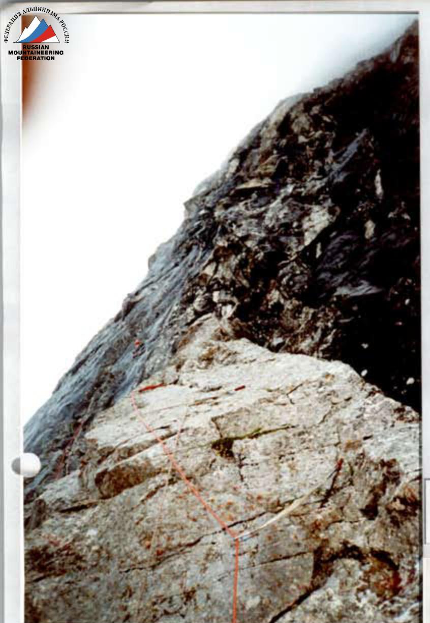
Technical photograph of the route
I c.t. – 3250 m. The ascent ended at the first control cairn due to rain. Overnight stay in the observers' camp on July 27, 2000.
II c.t. – 3380 m. Sitting overnight stay on July 28, 2000. 100 m processed above the control cairn.
Section R8
From the overnight stay at c.t. #2, along the ropes hung the day before, further up.
Ascent Logbook
- Climbing category – rock.
- Climbing area – Western Caucasus, Uzunkol, Kichkinekol valley.
- Peak Dalar 3979 m along the Northern wall of the bastion 6A category (Warburton's route).
- Height difference – 1150 m. Height difference of the bastion – 610 m. Route length – 1470 m. Average steepness of the bastion – 82°. Length of sections with 5 and 6 category difficulty – 540 m.
- Pitons used:
- Rock 58/5*
- Bolt 0/5*
- Chock stones 146/0
- Ice 3/0
- – previously used.
- Total climbing hours – 20.
- Overnight stays – 3. Two sitting – in a grotto, one on descent – on a ridge under the summit tower.
- Team Leader: Bershov S.I., Honored Master of Sports. Team Members: Svergun I.N., Master of Sports International Class, Badygin M.R., 1st sports category, Budrin E.V., 1st sports category, Shpak A.V., 1st sports category.
- Coach: Bershov S.I.
- Start of the route: July 23, 1996.
Waiting due to bad weather: July 24, 1996.
Reached the summit: July 25, 1996.
Returned to "Uzunkol" resort: July 26, 1996.
| Section | M | ° | Category |
|---|---|---|---|
| R0 | 40 | 50 | |
| R1 | 20 | traverse 4+ | |
| R2 | 40 | 80 | 5+ |
| R3 | 15 | 80 | 6 |
| R4 | 25 | 80 | 6+ |
| R5 | 35 | 80 | 5- |
| R6 | 15 | 80 | 5- |
| R7 | 40 | 95 | 6+, A3 |
| R8 | 20 | 90 | 6, A2 |
| R9 | 40 | 90 | 6, A2 |
| R10 | 40 | 95 | 6+, A3 |
| R11 | 20 | 90 | 6+, A1 |
| R12 | 20 | 90 | 6, A1 |
| R13 | 20 | 90 | 5 |
| R14 | 15 | 90 | 4 |
| R15 | 25 | 90 | traverse 6+ |
| R16 | 20 | 90 | 6+, A1 |
| R17 | 20 | 80 | 6, A1 |
| R18 | 20 | 80 | 6, A1 |
| R19 | 20 | 85 | 6, A2 |
| R20 | 30 | 85 | 6, A1 |
 |
| Section | M | ° | Category |
|---|---|---|---|
| R21 | 30 | 65 | 4+ |
| R22 | 40 | 60 | 5+ |
| R23 | 30 | 60 | 5+ |
| R24 | 35 | 85 | 6 |
| R25 | 35 | 65 | 4+ |
| R26 | 25 | 60 | 5+ |
| R27 | 350 | 45–50 | "knife" |
| R28 | 150 | 3+ | |
| R29 | 30 | 70 | 4+ |
| R30 | 40 | 70 | 4 |
| R31 | 40 | 70 | 4 |
| R32 | 35 | 75 | 4+ |
| R33 | 40 | 80 | 5+, A2 |
| R34–R37 | 100 | 40 | 5+ |
| R38 | 20 | 30 | 3+ |
| 


