Ascent Certificate
- Type of ascent — rock climbing.
- Region — Western Caucasus, Gvandra region.
- Peak DALAR, 3979 m, via the north-eastern wall of the bastion.
- Category of difficulty — 5B.
- Route characteristics:
height difference: total — 1200 m, bastion — 780 m, length of sections with 5–6 category difficulty — 850 m, average steepness of the bastion — 76° (2780–3560 m), sections with 6 category difficulty — 85° (3010–3050 m).
- Pitons hammered:
| Type | Rock | Bolt | Chock | Ice |
|---|---|---|---|---|
| Total | 133 | 2 | 68 | — |
| Previously hammered | 31 | 4 | 12 | — |
| x) use of previously hammered pitons |
-
Travel time — 30 hours, days — 3.
-
Overnights: 1st — sitting on ledges; 2nd — lying on a platform carved in a snowdrift under a cornice.
-
Leader — KHARITONOV Alexey Pavlovich — CMS participants:
- PAKHOMOV Vladimir Dmitrievich — CMS
- POVOLOTSKY Vladimir Yuryevich — MS
- CHIYANOV Nikolai Egorovich — CMS
- Senior coach — MIKHAILOV Alexander Alexandrovich — MS
- Coach — YAKOVLEV Vitaly Dmitrievich — MS
Departure to the route — June 28, 1983, return — July 1, 1983.

General view of Dalar peak. Photo #1
(1) route PorokHH, 78 g.
(2) route Korablina, passed by URVO team
(3) route Varburtona, 76 g.
(4) route Stepanova
(5) route Snesareva, 62 g.
(6) route Shopina
(7) route Korablina
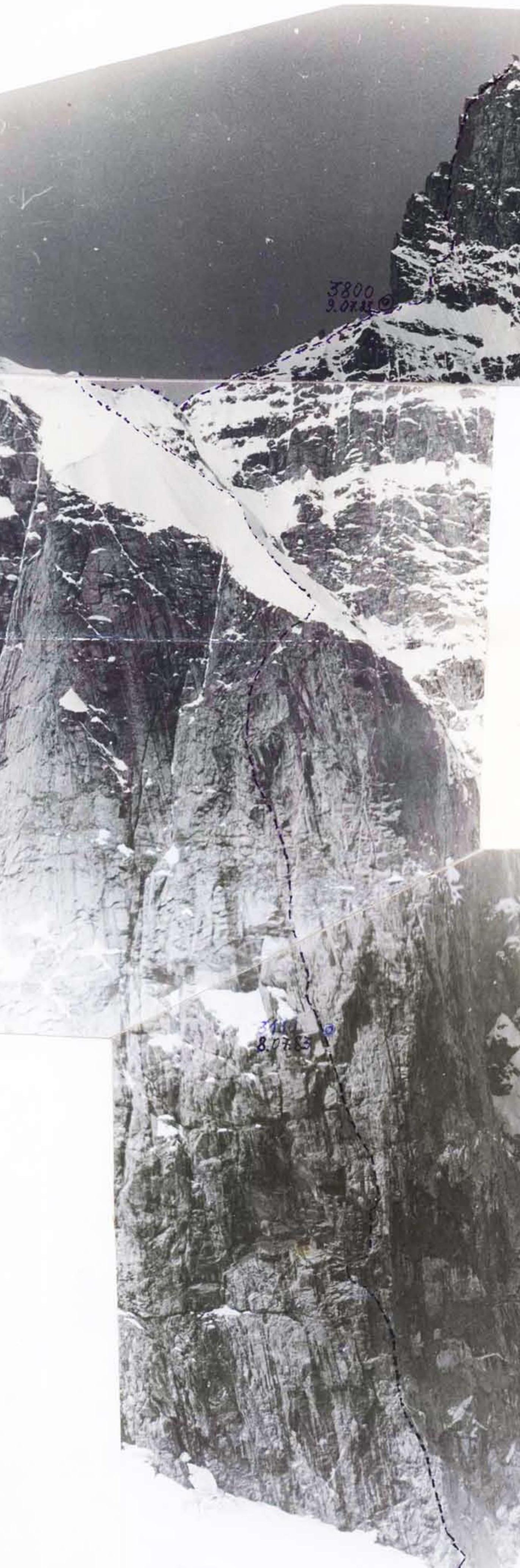
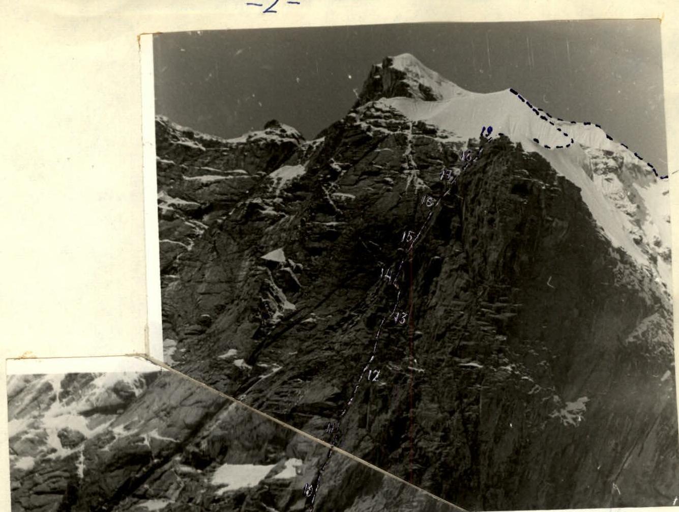
Technical photograph of the route
Date and time of shooting: July 3, 1983, 15:00. Lens: "Yupiter 25-C". Focal length: 85 mm. Distance to the wall: 2 km. Shooting point on the map: № 3. Height of the shooting point: 3000 m.
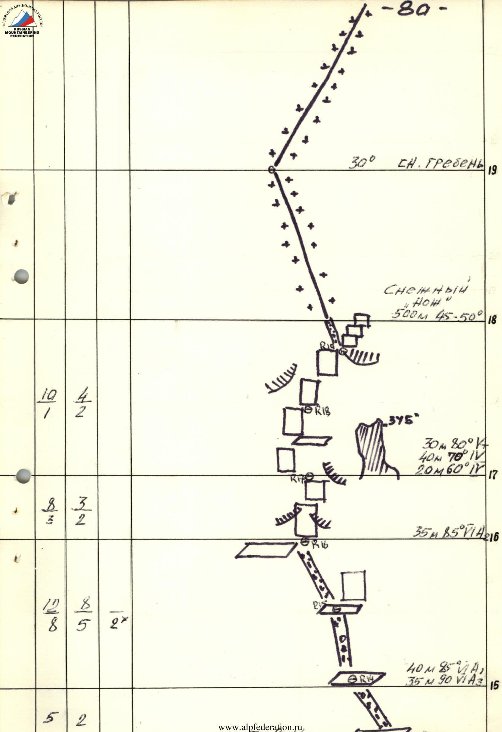
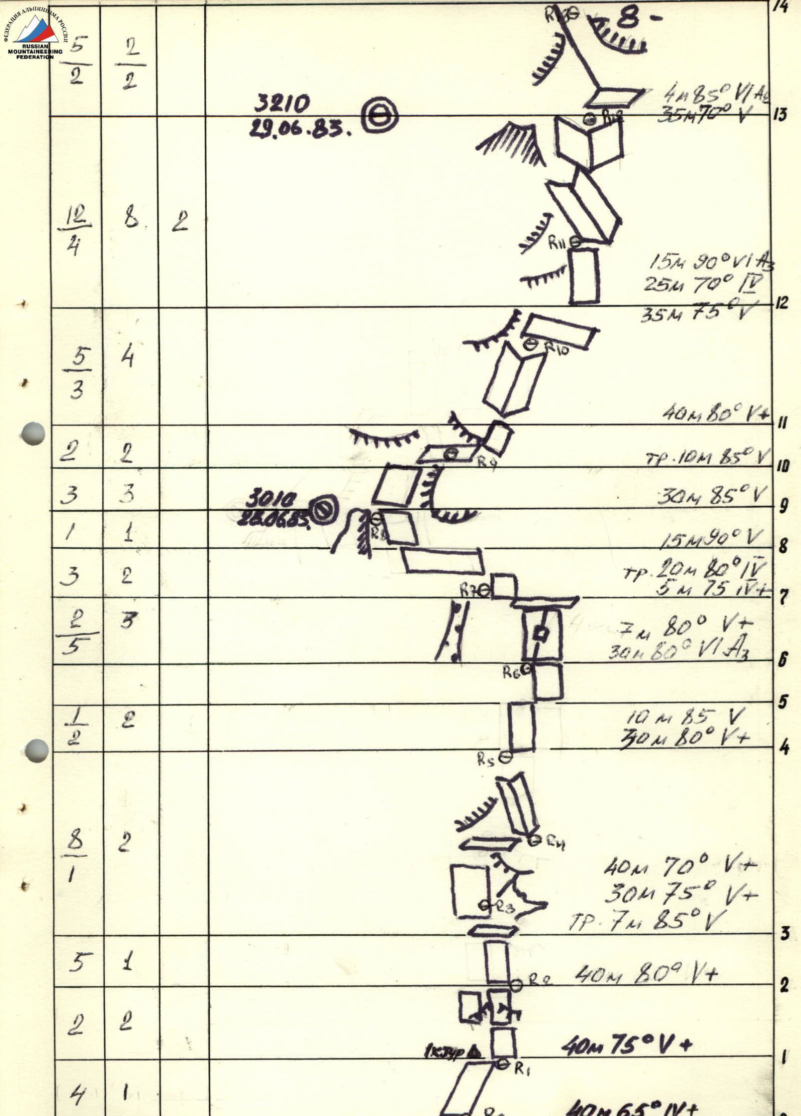
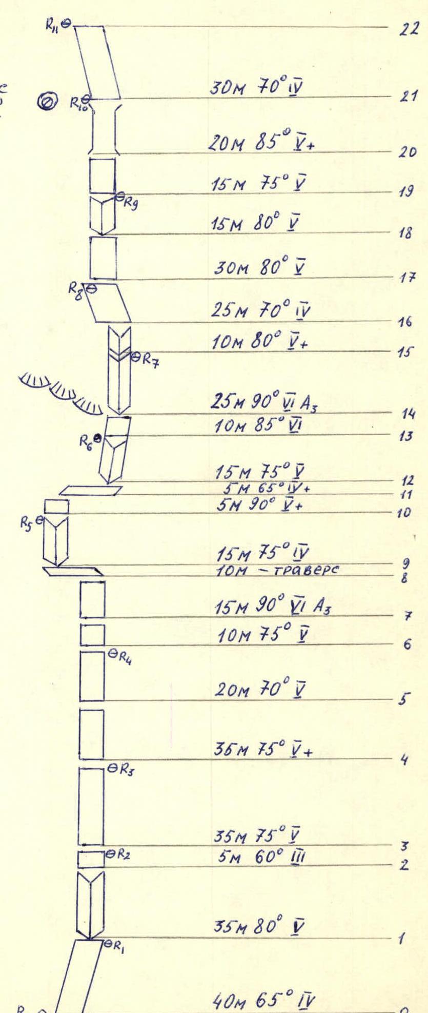
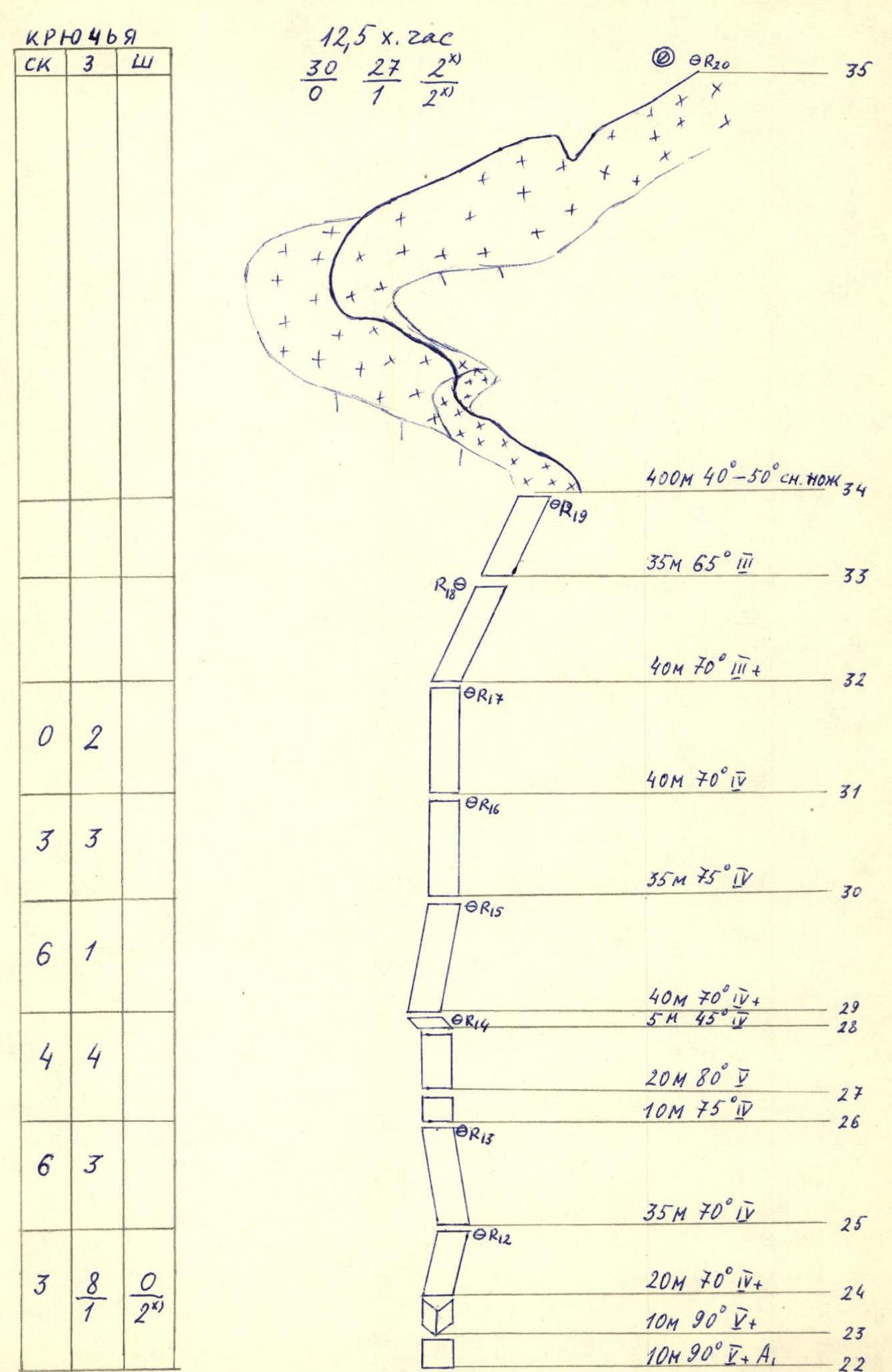
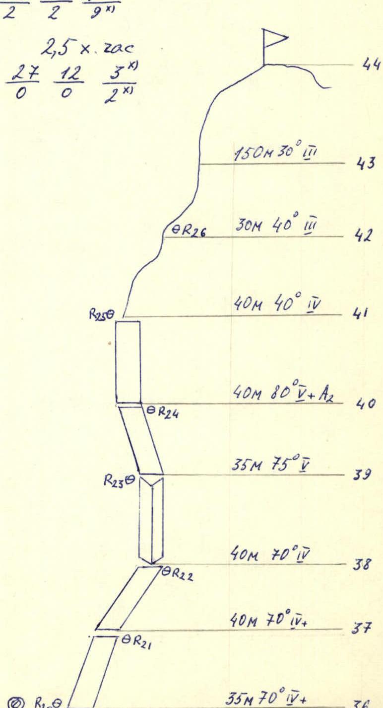
Route diagram in UIAA symbols
Time: 30 hours. Pitons (rock / chock / bolt): 133 / 68 / 2. Previously hammered: 31 / 12 / 4x. R0: 40 m, 65°, IV+ R1: 40 m, 75°, V+ R2: 40 m, 80°, V+ R3: 35 m, 75°, V; 5 m, 60°, III R4: 40 m, 70°, V+; 30 m, 75°, V+; Tension 7 m, 85°, V R5: 10 m, 85°, V; 30 m, 80°, V+ R6: 7 m, 80°, V+; 30 m, 80°, VI A3 R7: Tension 20 m, 80°, V; 5 m, 75°, IV+ R8: 15 m, 90°, V R9: 30 m, 85°, V R10: Tension 10 m, 85°, V R11: 40 m, 80°, V+ R12: 15 m, 90°, VI A3; 25 m, 70°, IV; 35 m, 75°, V R13: 4 m, 85°, VI A4; 35 m, 70°, V R14: 40 m, 70°, V+; 30 m, 75°, V+; Tension 7 m, 85°, V R15: 40 m, 80°, V+ R16: 35 m, 75°, V; 5 m, 60°, III R17: 20 m, 70°, V+; 10 m, 90°, V+; 10 m, 90°, IV+ A1 R18: 35 m, 70°, V R19: 20 m, 70°, V+; 10 m, 90°, V; 10 m, 90°, IV+ A1 R20: 35 m, 65°, III R21: 40 m, 70°, III+ R22: 40 m, 70°, IV R23: 35 m, 75°, IV R24: 40 m, 70°, IV+; 5 m, 45°, V R25: 20 m, 80°, V; 10 m, 75°, V R26: 35 m, 70°, V R12–R26: Snow "knife" 500 m, 40–50° R27: 35 m, 65°, III R28: 40 m, 70°, III+ R29: 40 m, 70°, IV R30: 35 m, 75°, IV R31: 40 m, 70°, IV+; 5 m, 45°, V R32: 20 m, 80°, V; 10 m, 75°, V R33: 35 m, 70°, V R34: 20 m, 70°, V+; 10 m, 90°, V+; 10 m, 90°, IV+ A1 R35: 35 m, 70°, V+ R36: 40 m, 70°, IV+ R37: 40 m, 70°, V R38: 35 m, 75°, V R39: 40 m, 80°, V+ A2 R40: 40 m, 40°, IV R41: 30 m, 40°, III R42: 150 m, 30°, III
Route description by sections
The entire route can be roughly divided into three parts:
- passing the bastion and reaching the snow-ice "knife",
- the snow-ice "knife" and reaching the pre-summit tower,
- the pre-summit tower and reaching the summit.
June 28, 1983. At 4:00, the group left the observer camp. At 7:00, the rope team Kharitonov — Pakhomov began working on the route, with Kharitonov leading. After passing five ropes, Kharitonov reached the site of the first planned overnight stay on the "flake" at 13:00. By 14:30, the entire group had gathered at the overnight stay. Pakhomov began, processing further sections of the route. By 17:30, when the weather turned bad, two ropes had been processed. The overnight stay was sitting on ledges, in the "flake" area.
June 29, 1983. At 8:00, Kharitonov began moving along the processed ropes. By 10:00, the duo Kharitonov — Pakhomov had passed the processed ropes, and Kharitonov began further route passage, climbing being very difficult, requiring IT use. By 13:30, the first rope team had passed two ropes, and the second team had finished passing the ropes processed the day before. At 16:00, the weather turned bad (rain, fog), and over eight hours of work, the group passed five ropes, including two slung the night before. There was nowhere to spend the night — a sheer wall. The group moved left 15–20 m and organized an overnight stay on a snowdrift under a rock cornice. Unexpectedly, they managed to set up a tent and sleep lying down. To ensure safety during the overnight stay, they had to:
- hammer in two bolt pitons.
June 30, 1983. At 8:00, the rope team Kharitonov — Pakhomov began working on the route, with Pakhomov leading. By 16:00, the group finished passing the bastion and gathered on a platform under the base of the "knife" (control cairn). At 16:30, the group began passing the "knife" in independent rope teams, with Chiyanov leading. At 17:30, the "knife" passage was completed. The group reached the base of the pre-summit tower at 18:30. Povolotsky led, and at 20:00, having completed the passage of the "mirror" and the summit ridge, the group reached the summit. Descending from the summit to the eastern shoulder, the group set up a bivouac on a snow platform. The overnight stay in the tent was lying down.
July 1, 1983. At 9:00, the group began descending via the 3B category difficulty route, and further through the Dalar pass, the group descended to the base camp by 15:00.
Ascent Certificate
- Type of ascent — rock climbing.
- Region — Western Caucasus, Gvandra region.
- Peak DALAR, 3979 m, via the north-eastern wall of the bastion.
- Category of difficulty — 5B.
- Route characteristics:
height difference: total — 1200 m, bastion — 680 m, length of sections with 5–6 category difficulty — 850 m, average steepness of the bastion — 74° (2780–3560 m), sections with 6 category difficulty — 85° (3010–3050 m).
- Pitons hammered:
| Type | Rock | Bolt | Chock | Ice |
|---|---|---|---|---|
| Total | 116 | 10 | 74 | — |
| Previously hammered | 2 | 9 | 2 | — |
| x) use of previously hammered pitons |
-
Travel time — 30 hours, days — 3.
-
Overnights: 1st — sitting on ledges; 2nd — lying in a tent on a platform.
-
Leader — Bishirov Alexander Petrovich — CMS participants:
- Shumikhin Yuri Arkadyevich — CMS
- Odintsov Sergey Alexandrovich — CMS
- Blinov Alexey Nikolaevich — CMS
- Coach — Yakovlev Vitaly Dmitrievich — MS.
- Departure to the route — July 7, 1983, return — July 9, 1983.
| Pitons | Rock | Chock | Bolt |
|---|---|---|---|
| 3 | |||
| 2 | 5 | ||
| 10 | 4 | ||
| 5 | 4 | ||
| 6 | 3 | ||
| 7 | 1 | 0/1ⁿ | |
| 5 | 5 | 0/1ⁿ | |
| 5/2 | 4/1 | 0/4ⁿ | |
| 7 | 3 | ||
| 5 | 5 | ||
| 6 | 2 | ||
| 3 | 4 |
Route diagram in symbols
Pitons: 116 rock (2 previously hammered), 10 bolt (9 previously hammered), 74 chock (2 previously hammered). 2.5 hours.
Pitons: 27 rock (0 previously hammered), 12 bolt (0 previously hammered), 3 chock (2 previously hammered).
Route diagram in symbols. Continued.
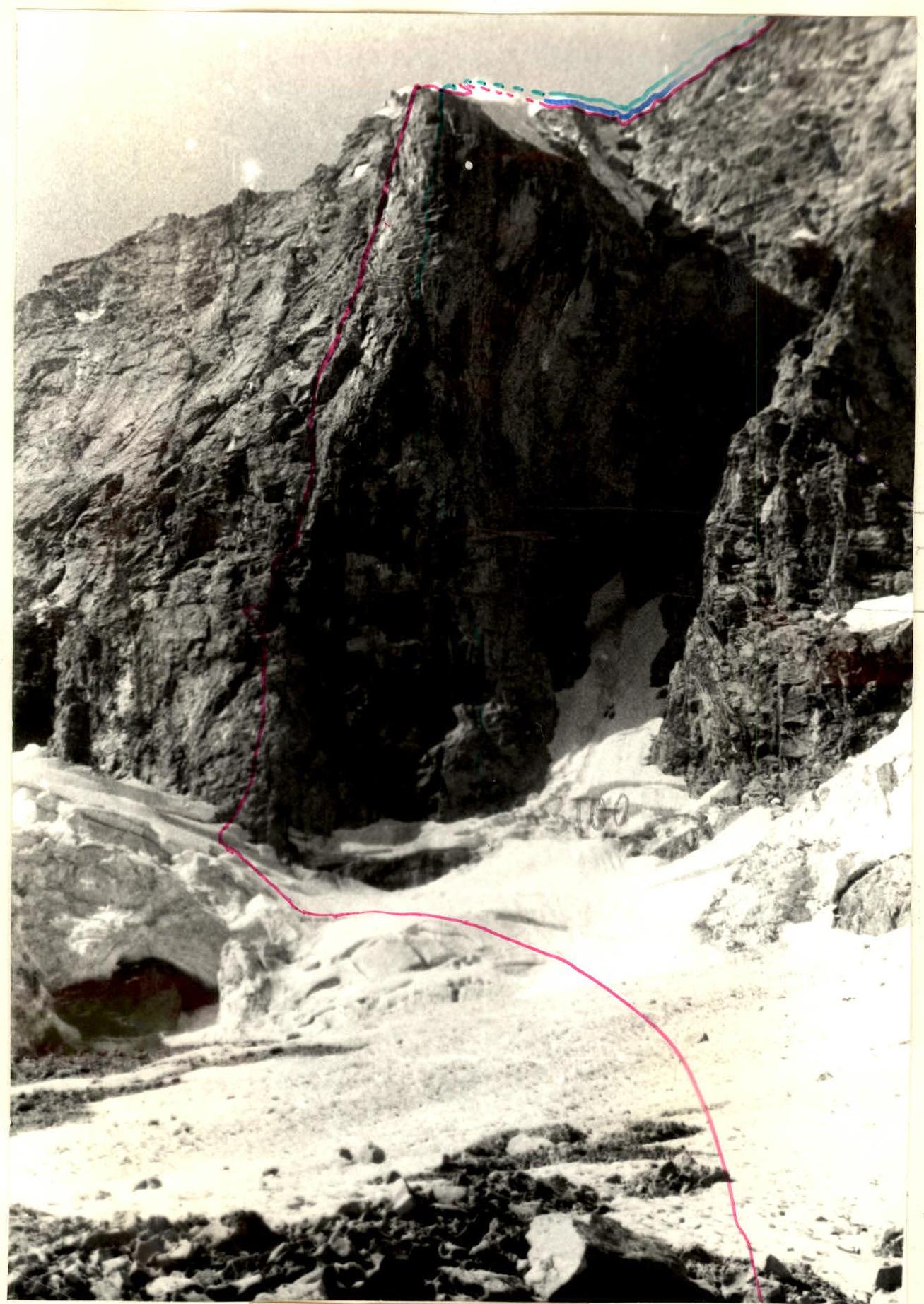
Profile of the wall on the right. Photo.
Date and time of shooting: July 3, 1983, 14:00. Lens: "Helios 44M". Focal length: 58 mm. Distance to the wall: 1 km. Shooting point on the area map: №2. Height of the shooting point: 2800 m.
Ascent Certificate
- Type of ascent — rock climbing
- Region — Western Caucasus from Marukh pass to Chipperazaou pass
- Peak, height, and ascent route — Dalar (3979 m), NE wall of the bastion (Korablina)
- Category of difficulty — 5B
- Route characteristics:
Height difference — 1080 m bastion — 620 m Average steepness of the bastion — 75° Length of sections:
- 2 category difficulty — 650 m
- 3 category difficulty — 60 m
- 4 category difficulty — 425 m
- 5 category difficulty — 505 m
- 6 category difficulty — 65 m
- Pitons hammered:
| Type | For belay | For ITO |
|---|---|---|
| Rock | 152 | 9 |
| Ice | 3 | 1 |
| Bolt | 5 | 10 |
-
Travel time — 19.5 hours
-
Number of overnight stays and their characteristics: total — 1 good — 1
-
Group composition: ANDRYUSHCHENKO A.V. — CMS BOYKO V.V. — 1st category KUZNETSOV Y.N. — 1st category NEDELKIN V.I. — 1st category VELMISEEV P.A. — 1st category
-
Team coach — KOVALENKO YURI IVANOVICH
-
Departure to the route — August 24, 1979
-
Return — August 26, 1979
General view of the peak
Korablina route — 5B category difficulty. Grakovich route (Druzhba) — 5B category difficulty. Part of Stepanov route — 5B category difficulty. Part of the route along the upper ridge — 5A category difficulty.
Table of main route characteristics
Character of the section
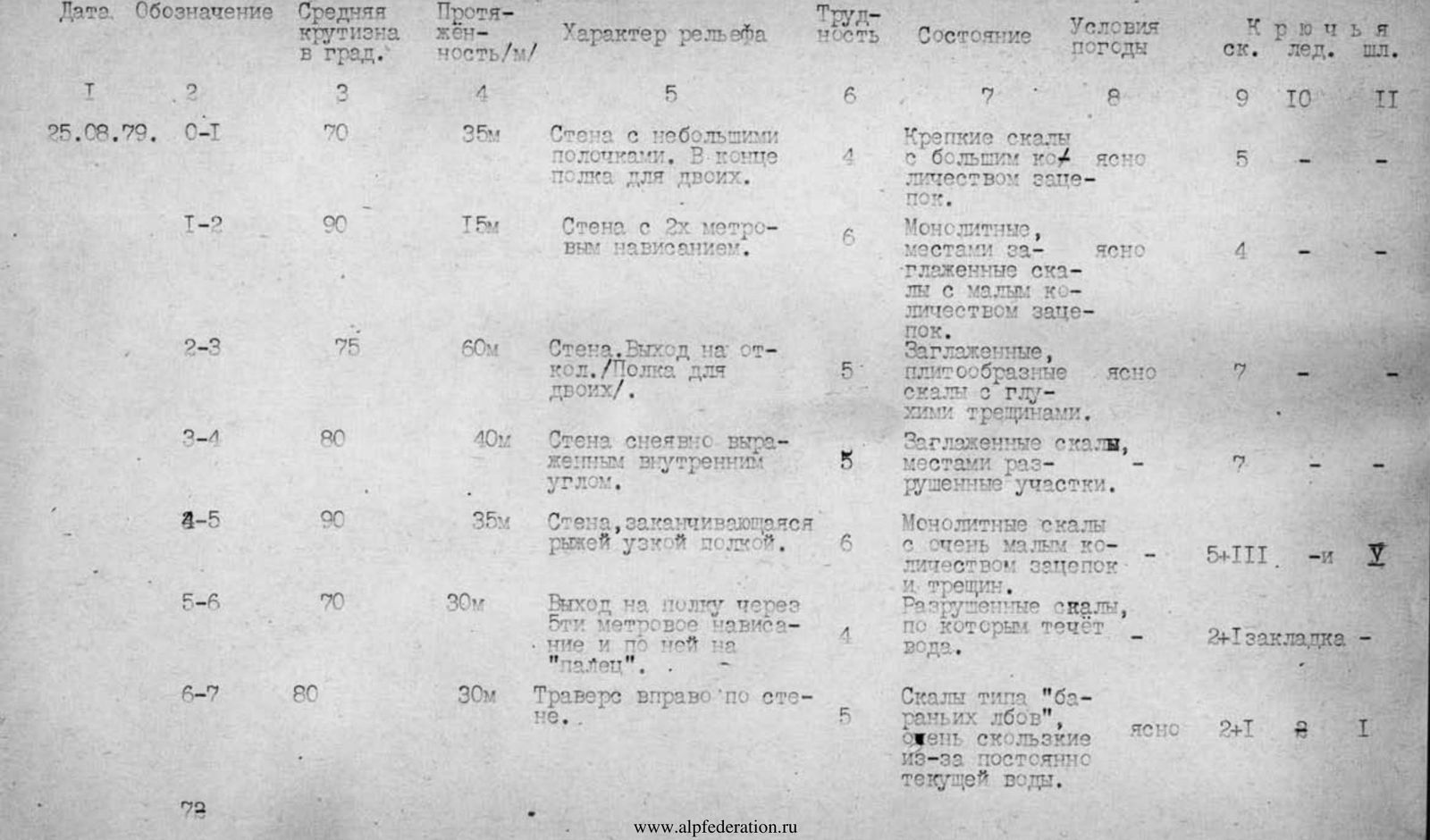

| Date. Designation | Average steepness in degrees | Length (m) | Character of relief | Difficulty | Condition | Weather conditions | Rock Pitons | Ice Pitons | Bolt Pitons |
|---|---|---|---|---|---|---|---|---|---|
| August 25, 1979 R0–R1 | 70 | 35 | Wall with small ledges. At the end, a ledge for two. | 4 | Firm rocks with many holds. | Clear | 5 | – | – |
| R1–R2 | 90 | 15 | Wall with a 2-meter overhang. | 6 | Monolithic, местами заглаженные скалы с малым количеством зацепок. | Clear | 4 | – | – |
| R2–R3 | 75 | 60 | Wall. Exit to a flake. Ledge for two. | 5 | Smooth, slab-like rocks with deep cracks. | Clear | 7 | – | – |
| R3–R4 | 80 | 40 | Wall with an unobvious inner corner. | 5 | Smooth rocks, местами разрушенные участки. | – | 7 | – | – |
| R4–R5 | 90 | 35 | Wall, ending in a narrow, rusty ledge. | 6 | Monolithic rocks with very few holds and cracks. | – | 5+III | – | 1 |
| R5–R6 | 70 | 30 | Exit to a ledge through a 2-meter overhang and along it to the "finger". | 4 | Decaying rocks, with water flowing through them. | – | 2+1 | chock | – |
| R6–R7 | 80 | 30 | Traverse right along the wall. | 5 | Rocks like "ram's foreheads", very slippery due to constantly flowing water. | Clear | 2+1 | – | 1 |
| R7–R8 | 80 | 50 | Wall with a 15-meter inner corner. Ledge for three. | 5 | Initially monolithic, then decaying rocks. | Clear | 8+II | – | P |
| R8–R9 | 70 | 30 | Inner corner with a slit. | 5 | Monolithic rocks. | – | 3+2 | chocks | – |
| R9–R10 | 80 | 20 | Wall with a 7-meter overhang. | 5 | Monolithic, smooth rocks. | – | 3+1 | chocks | – |
| R10–R11 | 60 | 40 | Inner corner with small sheer sections. | 5 | Monolithic rocks. | Clear | 7 | – | – |
| R11–R12 | 50 | 50 | Wall. | 4 | Slab-like rocks with few holds. | Clear | 7 | – | – |
| R12–R13 | 80 | 30 | Wall with a 3-meter overhang, turning into an inner corner, and then into a narrow chimney. | 5 | Monolithic, smooth rocks with few holds. | Fog | 3+1 | – | 2 |
| R13–R14 | 75 | 80 | Wall with a 2-meter overhang at the end. | 5 | Firm rocks with good holds. | Fog, rain | 12+2 | chocks | – |
| R14–R15 | 70 | 10 | Traverse along the wall left. | 5 | Slab-like rocks. | – | 3 | – | – |
| R15–R16 | 80 | 80 | Wall with several 2–3-meter overhanging sections. | 5 | Monolithic, smooth rocks. | – | 9+4 | chocks | 1 |
| R16–R17 | 65 | 70 | Wall with ledges and short sheer sections. Exit to the edge of the bastion. | 4 | Firm rocks. "Live" stones on the ledges. | Fog | 6+2 | chocks | – |
| August 26, 1979 R17–R18 | 30 | 250 | Thawed rock edge along the 2-shaped snow-ice ridge. | 2 | Slab-like rocks. | Clear | 2+ | outcrops | – |
| R18–R19 | 50 | 60 | Snow-ice slope. | 3 | Morning frosty ice and dense firn. | Clear | outcrops | – | 3 |
| R19–R20 | 10 | 250 | Rocky ridge with a 10-meter gap and small walls. | 2 | Decaying rocks. | Clear | outcrops | – | – |
| R20–R21 | 70 | 120 | Wall. | 4 | Slab-like rocks with good holds. | Clear | 12+4 | chocks | – |
| R21–R22 | 65 | 80 | Wall. Exit to the ridge. | 4 | Smooth, stepped rocks. | Clear | 2+2 | chocks | – |
| R22–R23 | 80 | 35 | Wall. | 5 | Smooth, monolithic rocks with few holds. | Clear | 6 | – | 2 |
| R23–R24 | 75 | 40 | Traverse left along the wall. | 4 | Rocks like "ram's foreheads". | Clear | 5+ | outcrops | – |
| R24–R25 | 90 | 15 | Wall with a cornice. | 6 | Large blocks. | Clear | 4 | 1 | 3 |
| R25–R26 | – | 150 | Ledge along the ridge. | 2 | Decaying rocks. | – | outcrops | – | – |
Brief explanation of the table
Team coach: (Kovalenko Yu.I.)
Time spent on passing sections:
- from bivouac to 2nd control cairn (R8) — 4.5 hours;
- from 2nd control cairn to the end of the bastion (R8–R17) — 9.5 hours;
- R17–summit — 5.5 hours.
On August 24, 1979, preliminary processing was conducted. A total of about 240 m of the wall was processed.
Due to the excellent physical preparation of the group members, rope pulling was not performed throughout the route. The first climber went with a lightened backpack (3–4 kg), having some necessary personal belongings in case of bad weather and some reserve equipment and supplies.
Food was organized so that each member had a necessary, pre-planned, and prepared supply of food and drink, and could have a snack independently of others, during their free time.
Chocks were widely used, mainly Abalakov's eccentric chocks, and a special device for removing pitons.
Having five ropes allowed each group member to move up using top-rope climbing with upper belay. The first climber climbed on a double rope.
All this, along with very clear work by all team members, contributed to a fast and reliable passage of the route.
The route is quite logical and not cluttered with old pitons, except for bolt pitons. The group used old pitons, none were hammered in.