
Dalar via NE wall, cat. 5B
I. Brief Geographical Description
The Dalar peak, with an elevation of 3981 meters above sea level, is located in the western part of the Central Uplift of the Main Ridge, southwest of the Elbrus peak (Gvandra area, Kichkinokol arch).
II. Sporting Characteristics of the Route and Its Exploration
Dalar is one of the most beautiful peaks in the Caucasus. The slightly northward-leaning rocky pyramid has long attracted the attention of mountaineers. The northeast wall, rising to almost 4000 meters, seemed particularly challenging yet interesting.
The sporty exploration of the walls began in 1956 when a group led by N.M. Semenov first traversed the NE wall up to the base of the tower and then deviated left from the route onto the relatively simple eastern ridge. In 1962, a group from the "Trud" sports society, led by V.V. Stepanov, repeated this path (up to the tower) and then straightened it, deviating from the original route in the last upper part (ascending directly up the tower to the summit). See photo #1.
In 1964, a group of Spartakovites led by V.D. Kavunenko followed Stepanov's path.
Tactical Plan and Route Description to Dalar Peak via the Northeast Wall, Cat. 5B (Combined)
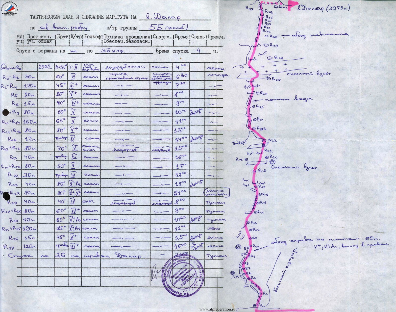 Photo #1
The NE wall is an extensive (over a kilometer) slope of great steepness, encircled by three rocky belts, and crowned with an almost sheer tower.
Characteristics of the wall:
- Predominantly rocky, without sharp bends;
- Very few places to bivouac;
- Almost no ledges;
- Requires many pitons for reliable protection;
- Mostly monolithic, composed of blocky and slab-like granite;
- Includes sections of wet rocks (resulting from melting snow patches and belts);
- Such sections are covered with a thin layer of ice at night, complicating movement, especially in the morning;
- Small snow patches disappear by the end of summer, making the wall almost dry; this is the recommended time for ascent.
The route via the NE wall is:
- Beautiful, direct, logical, and relatively safe;
- The most challenging sections are located at the bottom of the wall, around the III belt, and on the tower;
- Becomes extremely complicated even with slight deterioration in weather conditions, especially with precipitation.
© Main route characteristics are in the table on page 11
Ascent Description
July 18
During the day, the group traversed the lower part of the wall, the first rocky belt, and stopped to bivouac at the lower part of the II belt. The rope teams worked in the following order: Ruzhevsky - Kasparov; Nugmanov - Naumov. (The rope team order remained unchanged throughout the ascent.) To increase the pace, the group carried three backpacks, allowing the first climber to move lightly. Movement on all sections was alternating, with double-rope protection. The most challenging sections were R4, R6, R7, R10, and R13. After 14:00, the group settled on a small ledge, tied to pitons. They spent the night on an open bivouac. Strong winds and sleet occurred at night. Almost no one slept.
July 19
In the morning, movement became more complicated. Fresh snow covered the rocks. The group spent a lot of time and energy traversing the III belt (the most challenging section of the second day). This included steep (80–85°) rocks with streams of meltwater, especially around the R17 section (see the croquis on the last page). About 5 hours of challenging climbing were required to traverse R15, R16, and R17 sections, with 25 pitons hammered in just this area. After the III belt, the group continued in wet clothing. Unexpected snowfall and a thunderstorm forced them to stop at 15:30. They bivouacked at a bend in the rocky tower. They spent the night in a semi-reclined position.
July 20
Movement began at 6:00. The overall steepness after the tower's bend increased sharply. After an almost sheer wall (30 meters), the group encountered an unexpected danger.
Near the R24 section (see croquis), a large block shifted upon testing handholds. One careless move could send the block down... With great caution, the first climber descended 5–6 meters down the challenging wall. The decision was made to bypass the "live block" on the left under overhanging rocks (see photo #15).
This very difficult bypass required:
- Use of ladders;
- Installation of bolt pitons.
Climbing aids were successfully used on this section and beyond.
Next came:
- A vertical crevice;
- Followed by a 6-meter chimney.
Very interesting and challenging climbing.
Beyond the chimney lies a vertical inner corner composed of large blocks. Challenging climbing.
The upper tower from the bend is the most challenging section of the entire wall, requiring excellent technique and reliable protection.
Only by the end of the day did the group reach the summit and, descending slightly, spent the night on a large ledge. The bad weather that started in the evening continued throughout the night.
July 21
In the morning, it was raining. The descent followed the category 3B route. The group returned to "Uzunkol" at 13:30.
Overall assessment of the group members' actions and their characteristics:
There were no falls or tendencies towards them on the route. All participants worked clearly, competently, and efficiently. There were no disagreements on the path or in decision-making. The group was a cohesive and friendly collective.
Characteristics of participants:
Nugmanov N.S. is physically well-prepared. He has sufficient climbing experience. On the route, he was brave and enduring. His reaction to depth was excellent. Highly disciplined. A good teammate.
Naumov O.A. is physically well-prepared. Reliable, efficient, and unpretentious. Worked a lot and usefully on the route. Showed himself to be a collected and strong-willed athlete. Kind, caring, and reliable companion.
Kasparov K.N. is a sufficiently experienced climber with excellent physical preparation. On the route, he was accurate and attentive, hardworking, and proactive. Serious about protection. A good teammate.
Group leader: Ruzhevsky
Conclusion: The NE wall of Dalar, category 5B, was traversed in 34 hours of climbing time, with 102 rock pitons installed. Movement on all sections was alternating, with double-rope protection.
The numerous vertical crevices on the wall, interspersed with inner corners, somewhat facilitated free climbing but were tiring due to their uniformity.
The following were very helpful:
- "Vibram" boots;
- Correct tactics, allowing the first climber to move without a backpack;
- Working with a double rope;
- Use of climbing aids on very challenging sections.
This allowed the group to avoid pulling backpacks and move quickly without compromising protection.
The successful ascent was facilitated by:
- A rich, well-selected assortment of pitons;
- Good preparation of participants;
- Correct tactics.
On the route, the upper part of the wall was particularly challenging and interesting, with a constant feeling of depth. "It's a pity that the photographs don't convey the true difficulty of the route."
Table of Main Route Characteristics
- Route elevation gain: 1000–1050 m (excluding snow and ice relief).
- Length of the most challenging sections: 200–250 m.
- Route steepness: 65°.
- Steepness of the most challenging sections: 80–85°.
Route: Dalar via NE wall, cat. 5B. Elevation gain: 1000–1050 m (excluding snow and ice relief). Challenging sections: 200–250 m. Route steepness: 65°. Challenging sections steepness: 80–85°.

| Date | Section # | Steepness | Length | Section Description | Technique | Overcoming and Protection | Weather | Start Time | Stop Time | Climbing Hours | Rock Pitons | Ice Pitons | Bolt Pitons | Bivouac Conditions | Daily Rations Weight | Notes |
|---|---|---|---|---|---|---|---|---|---|---|---|---|---|---|---|---|
| July 8, 1966 | R2 | 70° | 15 m | Inner corner, rocks smoothed, water flowing | medium difficulty | free climbing (piton protection) | - | - | - | 2 | - | - | - | - | - | - |
| - | R3 | 50° | 120 m | Scree ledge, heavily destroyed, sometimes disappearing and turning into walls | simple | climbing, difficult to organize protection (everything is "loose") | - | - | - | 4 | - | - | - | - | - | - |
| - | R4 | 80° | 20 m | Wall, monolithic rocks | difficult | climbing, piton protection | - | - | - | 4 | - | - | - | - | - | - |
| - | R5 | 45° | 15 m | Ledge with grass, unfavorable slope | medium difficulty | – | - | - | - | 2 | - | - | - | - | - | - |
| - | R6 | 75° | 20 m | Wall, few handholds | very challenging | – | - | - | - | 5 | - | - | - | - | - | - |
| - | R7 | 80° | 20 m | Bypass of overhanging rocks, monolithic blocks | challenging section | – | - | - | - | 5 | 1 previously installed | - | - | - | - | - |
| - | R8 | 70–75° | 35 m | Inner corner | above medium difficulty | free climbing (piton protection) | - | - | - | 5 | - | - | - | - | - | - |
| - | R9 | 70° | 50 m | Inner corner turning into a crevice, solid rocks | medium difficulty | climbing (piton protection) | - | - | - | 5 | - | - | - | - | - | - |
| - | R10 | 60–65° | 35 m | Steep slabs, few handholds and cracks | very difficult | climbing with ladders, piton protection | - | - | - | 8 | 2 previously installed | - | - | - | - | - |
| - | R11 | 65° | 150 m | Steep ridge; many handholds and cracks | medium difficulty | climbing, piton protection | - | - | - | 8 | - | - | - | - | - | - |
| - | R12 | 75° | 80 m | Crevice, wet and brittle rocks, wide vertical cracks | above medium difficulty | climbing, pitons, wedges, boxes | - | - | - | 8 | - | - | - | - | - | - |
| - | R13 | 70° | 20 m | Lower part of the second belt, smooth rocks, water flowing | difficult | challenging climbing, piton protection | - | - | - | 5 | +5 pitons for bivouac | - | - | - | - | - |
| July 19, 1966 | R14 | 70° | 65 m | Narrow crevice turning into a steep gully, water | above medium difficulty | climbing, piton protection | - | 5:45 | 15:30 | 9 h 45 min | 7 | - | - | - | 700 g | - |
| - | R14–R15 | 40–50° | 30 m | Snow ledge, sour snow, rock inclusions | simple section | piton protection (cannot use ice axe for protection) | - | - | - | 2 | - | - | - | - | - | - |
| - | R15 | 80° | 40 m | Inner corner, water flowing | challenging section | challenging climbing, piton protection | - | - | - | 6 | - | - | - | - | - | - |
| - | R16 | 80–85° | 30 m | Wall, monolithic rocks, water flowing, some handholds | challenging section | very challenging climbing | - | - | - | 6 | - | - | - | - | - | - |
| - | R17 | 80° | 40 m | Top of III rocky belt, stream of water from above, few handholds, many cracks | very challenging section | – | - | - | - | 11 | 1 | - | - | - | - | - |
| - | R18 | 45° | 25 m | Rocky outcrop, "sheep's foreheads" type rocks, many "live stones" | simple section | climbing | - | - | - | 2 | - | - | - | - | - | - |
| - | R19 | 40° | 40 m | Snow belt, loose snow | simple section | three steps, protection from below via rock pitons | - | - | - | - | - | - | - | - | - | - |
| - | R20 | 50° | 30 m | Stepped rocks, many "live blocks"; slabs | medium difficulty | climbing, pitons, ledges | - | - | - | 2 | +4 pitons for bivouac organization | - | - | - | - | - |
| - | R21 | 55° | 60 m | Smoothed rocks, "sheep's foreheads" type | medium difficulty | climbing, piton protection | - | - | - | 5 | - | - | - | - | - | - |
| July 20, 1966 | R22 | 20° | 50 m | Scree ledge, ice with embedded scree on the ledge, sufficiently wide | simple | simple climbing | - | 6:00 | 18:00 | 12 h | 2 | - | - | - | 700 g | Reached the summit at 15:30 |
| - | R24 | 35–90° | 12 m | Very challenging section, rocks with blocky structure | very challenging bypass | very challenging climbing, ladders | - | - | - | 4 | 1 | - | - | - | - | Bypass of live block |
| - | R23 | 80° | 30 m | Wall, solid rocks, many handholds | above medium difficulty | enjoyable climbing | - | - | - | 4 | - | - | - | - | - | - |
| - | R25 | 80° | 55 m | Vertical wide crack, 0.5 m deep; monolith | challenging | challenging climbing | - | - | - | 8 | - | - | - | - | - | - |
| - | R26 | 85° | 6 m | Medium chimney, solid rocks | challenging | challenging climbing, piton protection | - | - | - | 2 | - | - | - | - | - | - |
| - | R27 | 80° | 120 m | Large crevice turning into an inner corner - vertical-blocky rock structure | challenging section | challenging climbing | - | - | - | 12 | - | - | - | - | - | - |
| - | R28 | 75° | 25 m | Rocks before reaching the ridge | medium difficulty | climbing, piton protection | - | - | - | 3 | - | - | - | - | - | - |
| - | R29 | 25° | 70 m | Pre-summit ridge, monolithic rocks, many ledges | medium difficulty | climbing, simultaneous movement protection | - | - | - | 1 | The table includes the total number of pitons installed (self-protection, bivouac organization, etc.) | - | - | - | - |
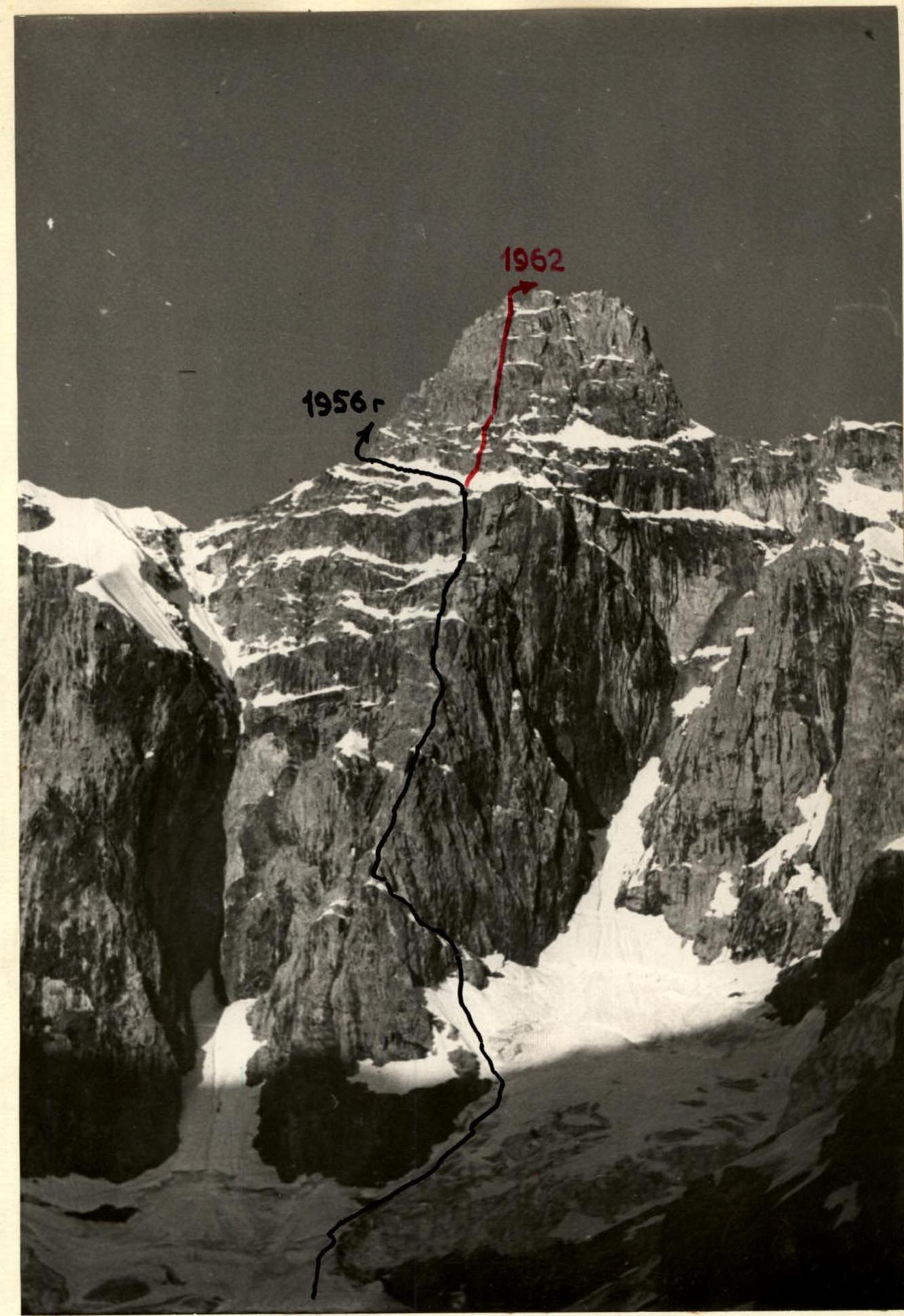 Photo #2
 Photo #2. Wall (section #R4)
Comments
Sign in to leave a comment