St. Petersburg Championship in mountaineering 2009
Report
UTS FASIL St. Petersburg team on the ascent of Dalar peak via Tramontana route (northern buttress of the northern shoulder), first ascent.
Table of Contents
Contents
Route Passport Map of the area with the group's path Brief overview of the area and the ascent object Photograph of the summit with route lines Pre-ascent preparation Safety measures Brief description of ascent conditions in Uzunkol valley in summer 2009 Route progression order UIAA symbol route diagram Route profile Route description by sections Equipment table Route characteristics GPS coordinates and altitude of certain route points Group's route sheet scan
Route Passport
-
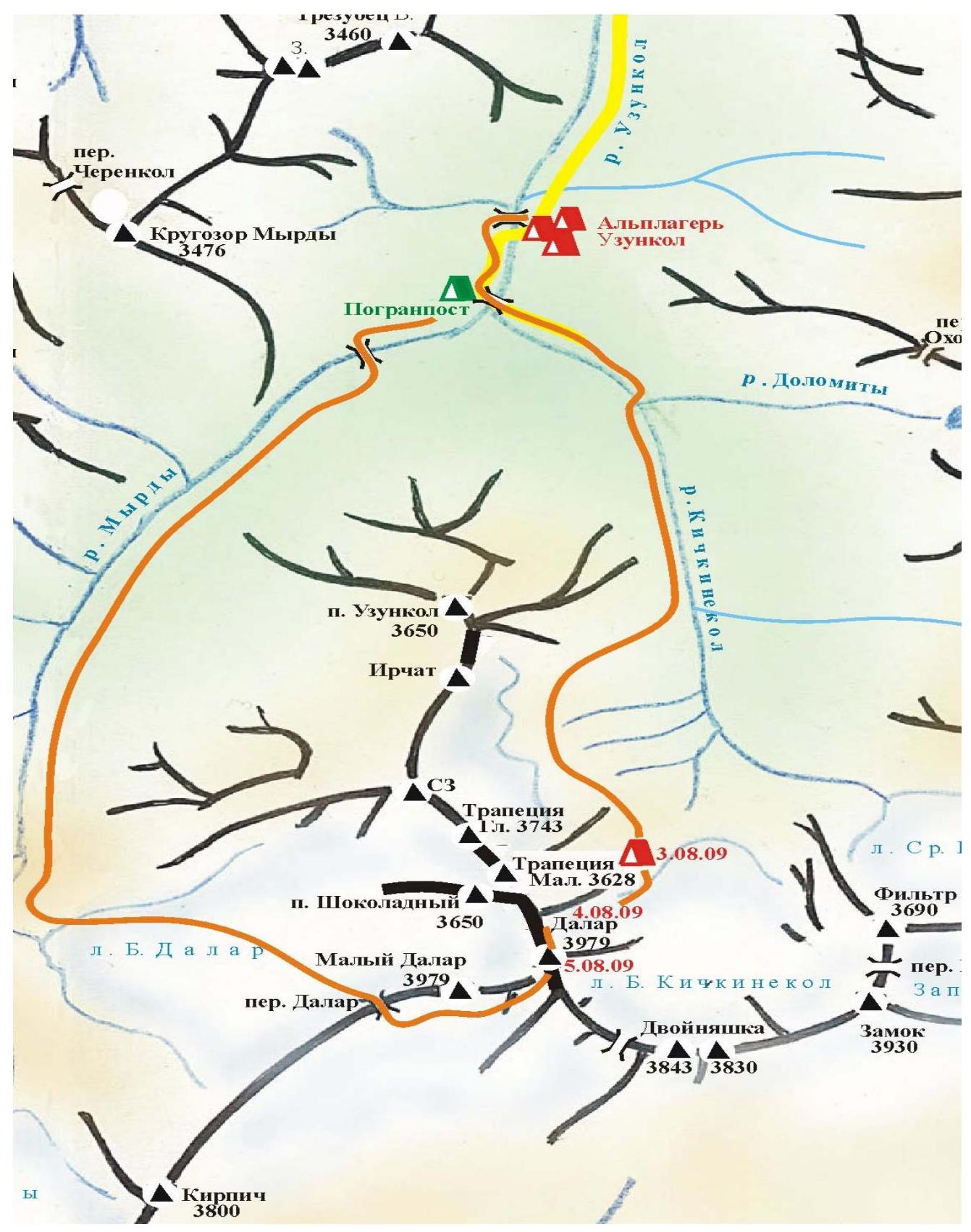
Area — Western Caucasus from Nakhar pass to Chiperezaou pass, Kichkinekol valley, section number according to KMGV 2008 — 2.3.
-
Summit name — Dalar, height 3988 m, route name — Tramontana, via northern buttress of the northern shoulder.
-
Proposed 5B category, first ascent.
-
Route character — combined.
-
Route height difference 1365 m (by altimeter).
Route length 1981 m. Section lengths:
- V category — 299 m
- VI category — 120 m. Average route steepness — 70°.
-
Hooks left on the route: total 0; including bolted 0. Used on the route: rock crab 34, chocks etc. 327. Hooks used: bolted stationary 0, bolted removable 0.
-
Team's climbing hours: 22 h 47 min, 2 days.
-
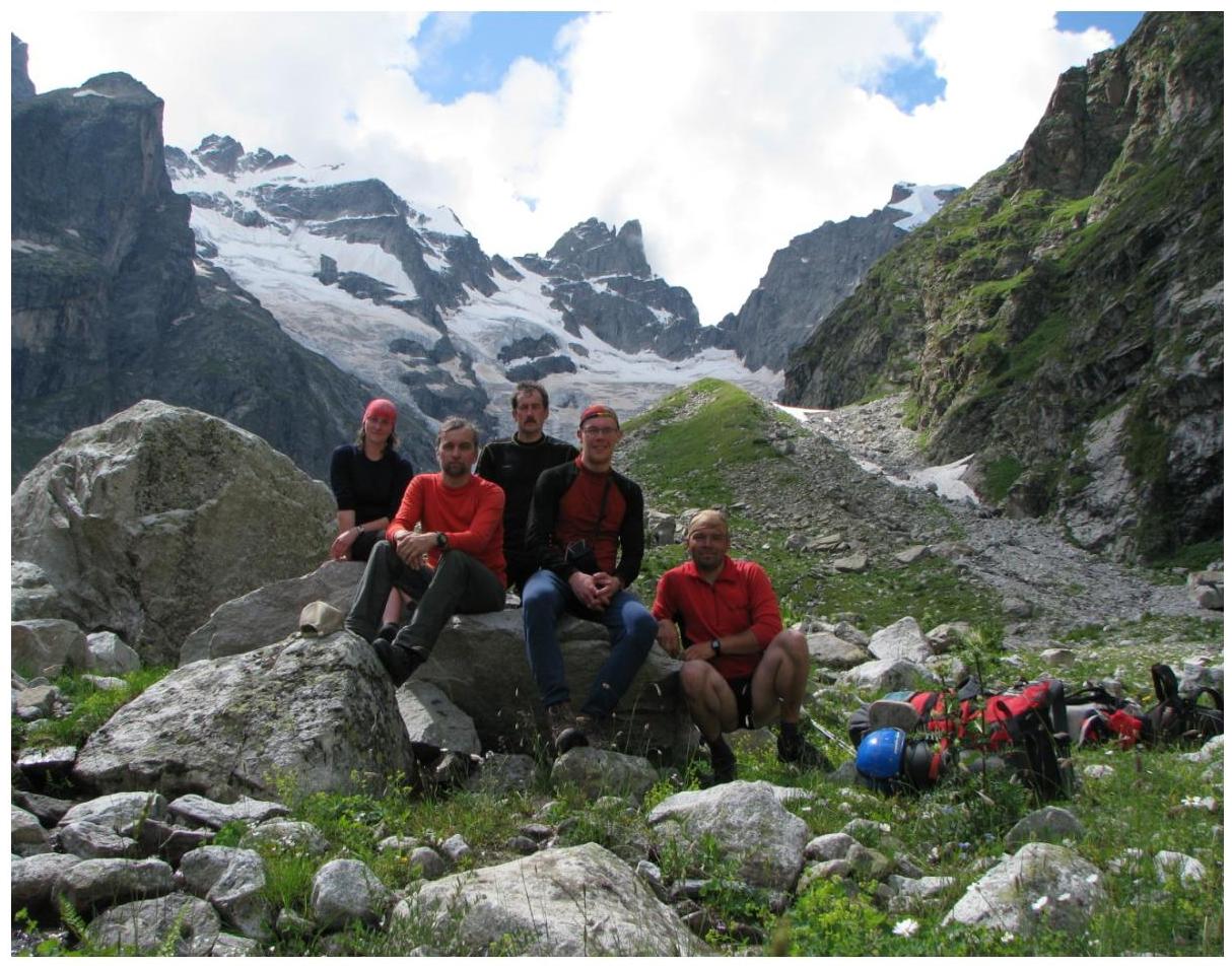
Leader: Denis M. Kiselyov, CMS. Participants:
- Eduard R. Rubtsov, CMS
- Dmitry L. Gubanov, 1st sports category
- Olga B. Shulenina, 1st sports category
-
Coach: Eduard R. Rubtsov, CMS.
-
Route entry — 4:35, August 3, 2009. Summit exit — 16:50, August 4, 2009. Return to BL — 16:00, August 5, 2009.
-
Organization — Federation of Mountaineering, Rock Climbing, and Ice Climbing of St. Petersburg.
Brief Overview of the Area and Ascent Object
Dalar (3979 m) is one of the most beautiful peaks in the Caucasus. Dalar is located in the Gvandrinsky region of the Western Caucasus within the Central Uplift of the Main Caucasian Range, 25 km southwest of Elbrus. The peaks in this region are mainly composed of strong granite-gneiss rocks with minimal cracks and smoothed microrelief.
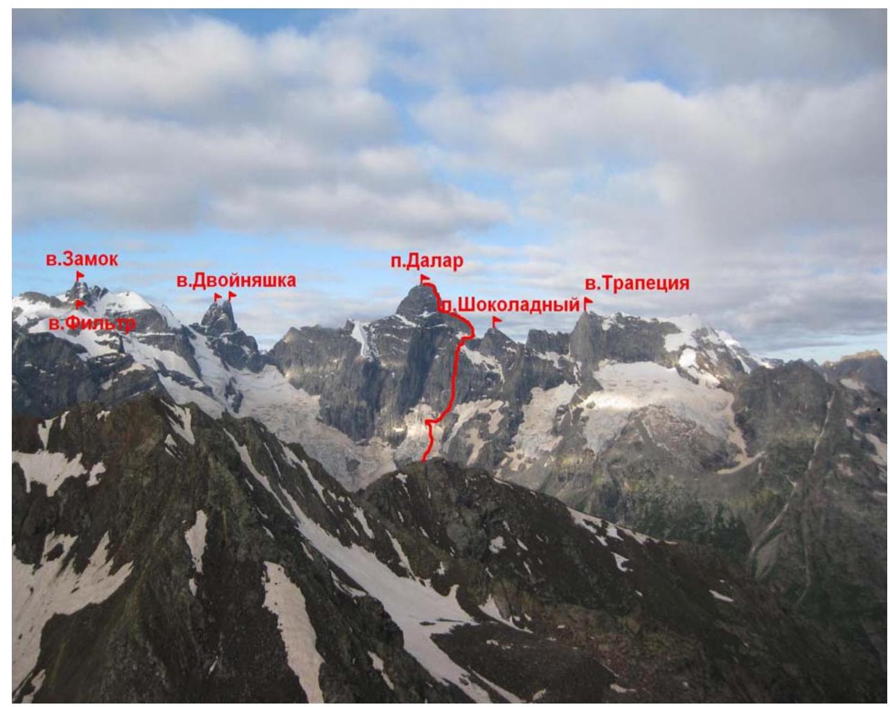
The main peaks of the Gvandrinsky region: Kirpich (3800 m), Dalar (3979 m), Dvoynyashka (3830 m), Zamok (3930 m), and Trapeция (3743 m) generally do not have easy paths; their walls are among the most difficult in the Caucasus.
The chain of peaks Filter — Zamok — Dvoynyashka — Dalar — Shokoladny peak, located in the upper reaches of the Kichkinekol valley, limits the Big Kichkinekol glacier cirque from the east, west, and south, giving rise to the eponymous river, which flows into the Uzunkol river.
Dalar and surrounding peaks
The valley and river, originating from the southern spurs of the peak, are called "Dalar" by the Svan people, linking the legend of the goddess of hunting Dali with the location of her throne ("ar" means here). The Karachay people call this peak "Kichkinekol Suyru", meaning "Big sheer cliff in Kichkinekol". Indeed, the northern slopes of the peak drop off with a kilometer-high sheer wall onto the glacier at its foot.
The first ascent of Dalar was made in 1937 by Kizel and Budanov's group via the 4A category route from the Dalar pass. Currently, 16 mountaineering routes lead to the summit, including:
- four routes with a complexity category of 6A;
- six routes — 5B.
Routes on Dalar are classic examples of technically complex mountaineering and have repeatedly won prizes at USSR and Ukraine championships.
"There are such alluring, tempting peaks, promising good climbing. There's the harsh Zamok, there's the gloomy, fantastic Dalar, and what an amazing Dvoynyashka, resembling a model of Ushba — a whole new world, indeed! No one has made real ascents there yet. I feel my heart is still there. There are such small glaciers, such cozy ledges, serious walls, sharp ridges. In short, everything you need to get real joy from climbing in a completely unknown area" — Mark Aronson enthusiastically told his older friend, writer Nikolai Tikhonov, about his trip to Gvandru. He continued: "And the peaks aren't that small: Dalar – 3979 meters, Dvoynyashka – 3900, Zamok 3930, Kirpich – 3800. All peaks have different faces — it's like drawing portraits."
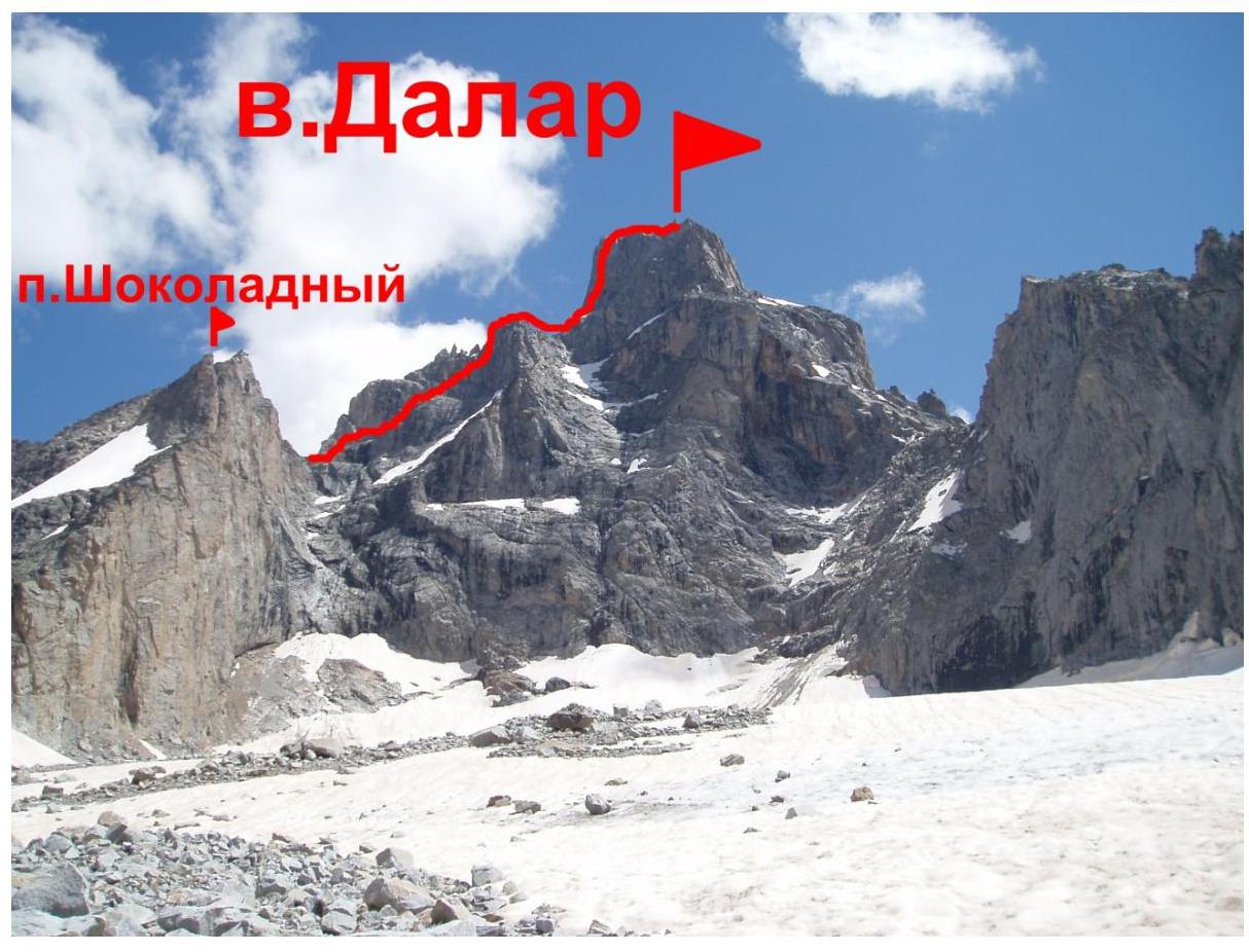
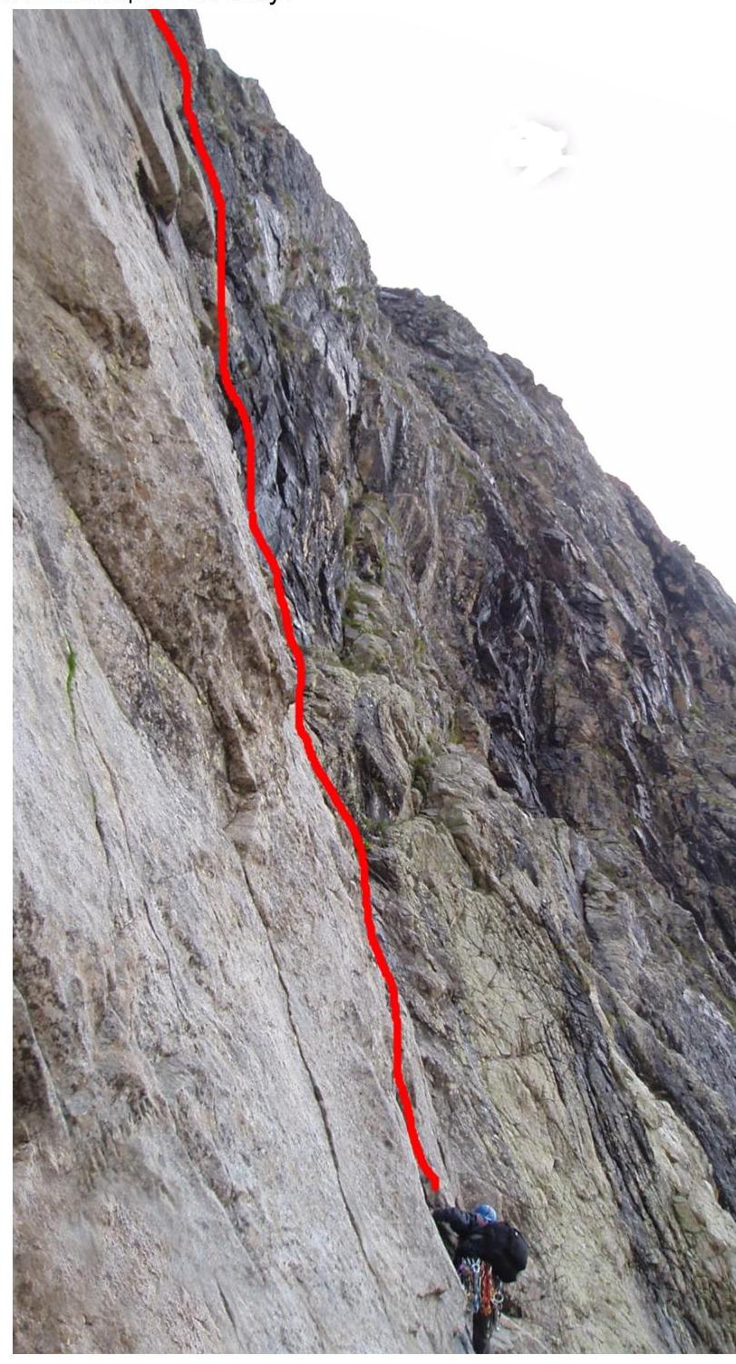
Photograph of the Summit with Route Lines
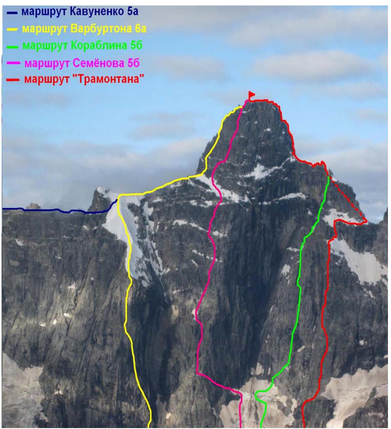
D. Kiselyov
Pre-ascent Preparation
The possibility of ascending Dalar via a new route was noticed by the group leader in summer 2008. Throughout autumn and winter, during lengthy and painstaking work with photographs, the route line was refined and adjusted.
Preparation and selection of participants for the ascent began in the fall of the previous year. A clearly planned calendar training plan eventually yielded results. Numerous training sessions on the rocks of the Karelian Isthmus, in Crimea, and in the area of the upcoming ascent improved the group's technical preparedness. Training mainly focused on practicing teamwork and climbing with lower belay on complex terrain. Several 5th category ascents were made in Crimea and Uzunkol during preparation. All this allowed hoping for success even on the most technically complex and prolonged ascent.
The group was not limited in technical means, but during preparation, preference was given to using chocks rather than rock and bolted hooks.
For bivouacs, special Zdarska tents were prepared, which are lightweight and adapted for sitting or semi-reclining overnight stays, although not very comfortable.
For overnight stays:
- two sleeping bags, zipped together
- participants' down jackets
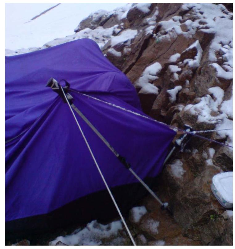
Zdarska tent on the route
For ease of orientation on the route, photographs of the initial terrain sections were printed. A GPS receiver was taken on the ascent.
Before heading out on the route, the group made ascents on Dalar via Kavunenko and Stepanov routes, 5B category.
On August 1st and 2nd, observations were made along the route using optics. During the observation, the most complex and dangerous sections of the route were identified, and the tactical ascent plan was finally adjusted.
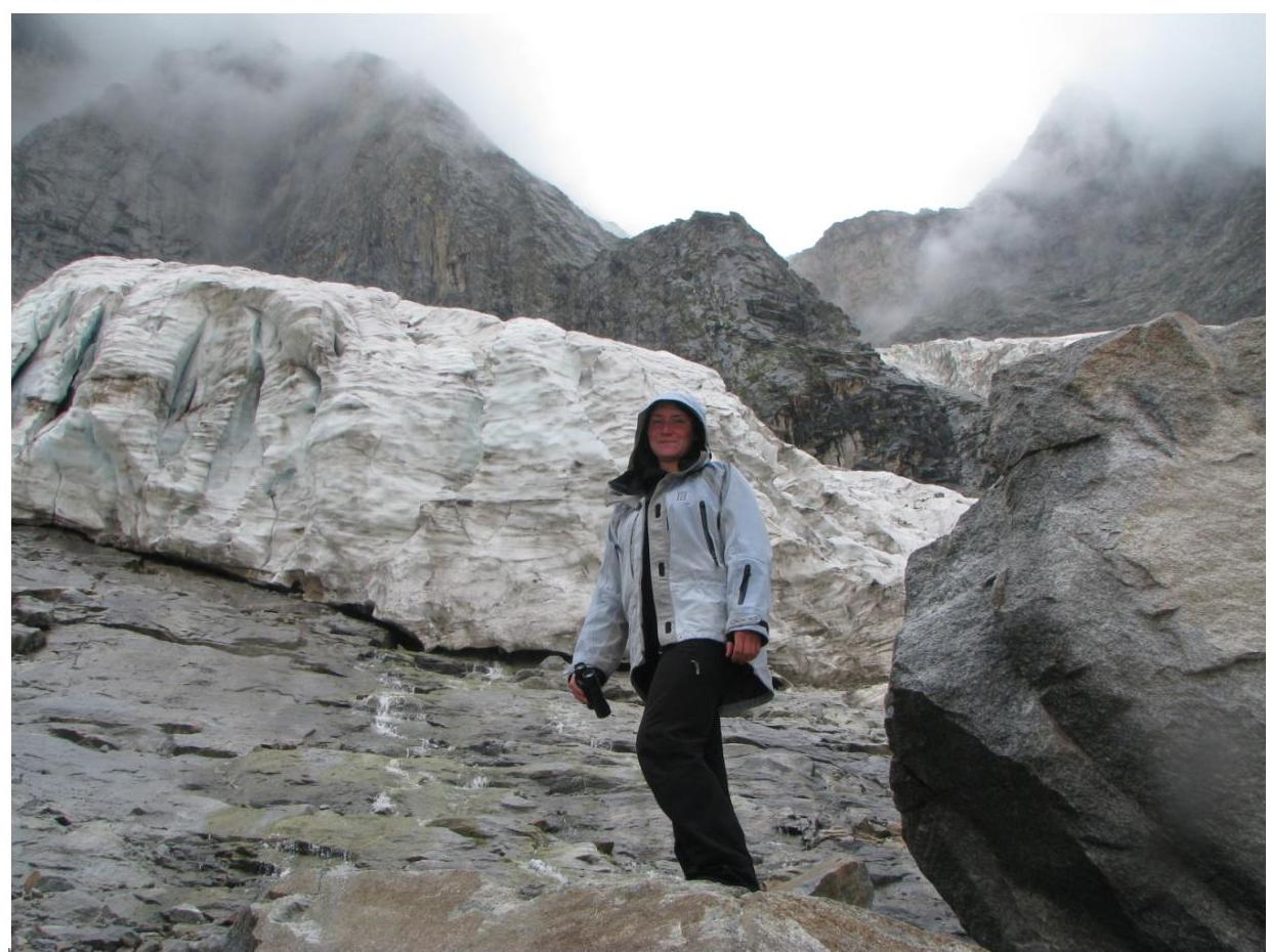
Observing the route, O. Shulenina
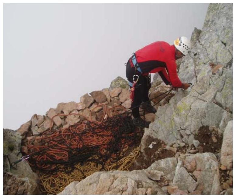
Safety Measures
During pre-ascent training, various options for conducting rescue operations on complex terrain were practiced. Particular attention was paid to:
- freeing a trapped climber
- providing first medical aid.
Emergency descent paths from the route were carefully considered at various stages of the ascent.
The group was registered with the rescue team at the Uzunkol alpine base (responsible for safety — Vladimir I. Enin). Communication with the camp was carried out using a Yaesu FT-60R portable radio station. The following were established:
- communication schedule with the camp;
- group's call sign.
The group's safety package included a first-aid kit containing all necessary medications for providing first medical aid. Before releasing the participants for the ascent, Dr. Sevostyanov examined them.
Brief Description of Ascent Conditions in Uzunkol Valley in Summer 2009
Summer 2009 was cold and rainy. Weather in the area changed frequently and unpredictably. Sunny and fair days were few. Prolonged bad weather was interrupted by short and unstable periods of sunny weather. Even on sunny days, it often rained in the evening, and snow fell in the glacier zone.
Ascents without bivouac equipment became dangerous and were often interrupted by periods of "sitting out." Early August — usually a time of stable and sunny weather in the Caucasus — was marked by rain and snow this year. Night temperatures dropped below 0°C, although they could rise to 10–15°C during the day.
Route Progression Order
The group left the Uzunkol alpine camp on August 1st at 9:00.
Group approaching the bivouac in the moraine pocket
It was sunny, and by 13:00, participants reached the bivouac site in the right moraine pocket of the Big Kichkinekol glacier. The rest of the day was planned for observing the wall, but a strong hailstorm with rain changed the plans. The weather deteriorated sharply. Short clearings around the fifth hour of the day allowed the coach and leader to examine the lower part of the wall, the top of which was hidden by clouds.
It rained throughout the night and morning. Therefore, it was decided not to start the route on August 2nd but to spend the day on reconnaissance and preparation. At 9:00 AM, the group's decision was communicated to the base via radio.
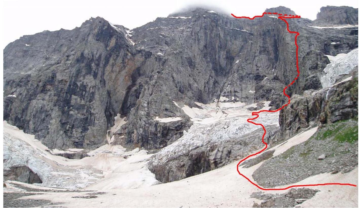
By mid-day, the weather had somewhat improved, and the Kiselyov—Shulenina pair went to the Big Kichkinekol glacier for route observation. During the observation, good landmarks were noted: a black rock at the bottom right of the wall's start, a rock with black streaks in the middle part of the route. The upper part of the wall was hidden by clouds. The reconnaissance also allowed for planning the safest path to the wall and better understanding the significantly changed glacier over the year. All this helped in better orientation under morning twilight conditions.
The weather soon deteriorated again, and the reconnaissance group returned to the bivouac.
Clearing was only expected with the onset of darkness. Rise at 4:00. The night was starry and clear — this allowed hoping for success. After a light breakfast, the group left the bivouac for the ascent at 4:35.
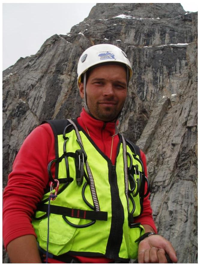
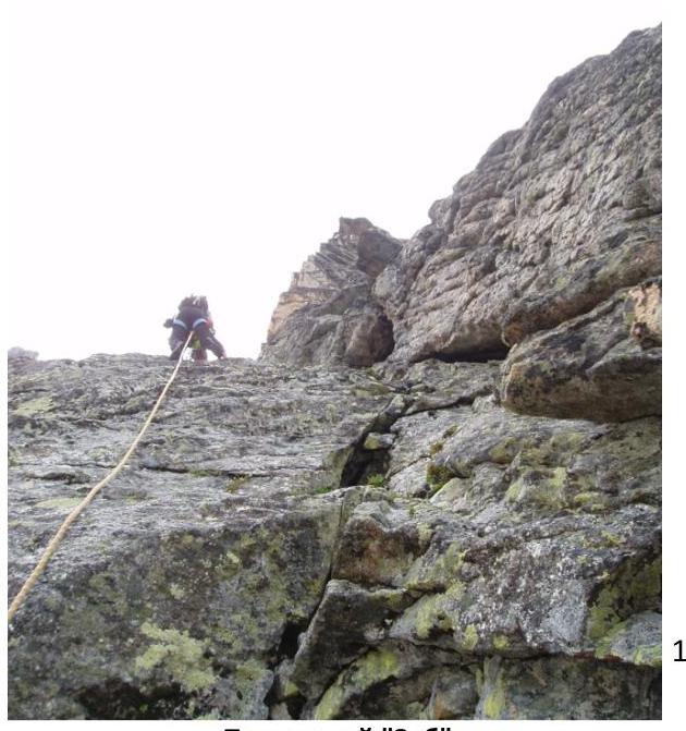
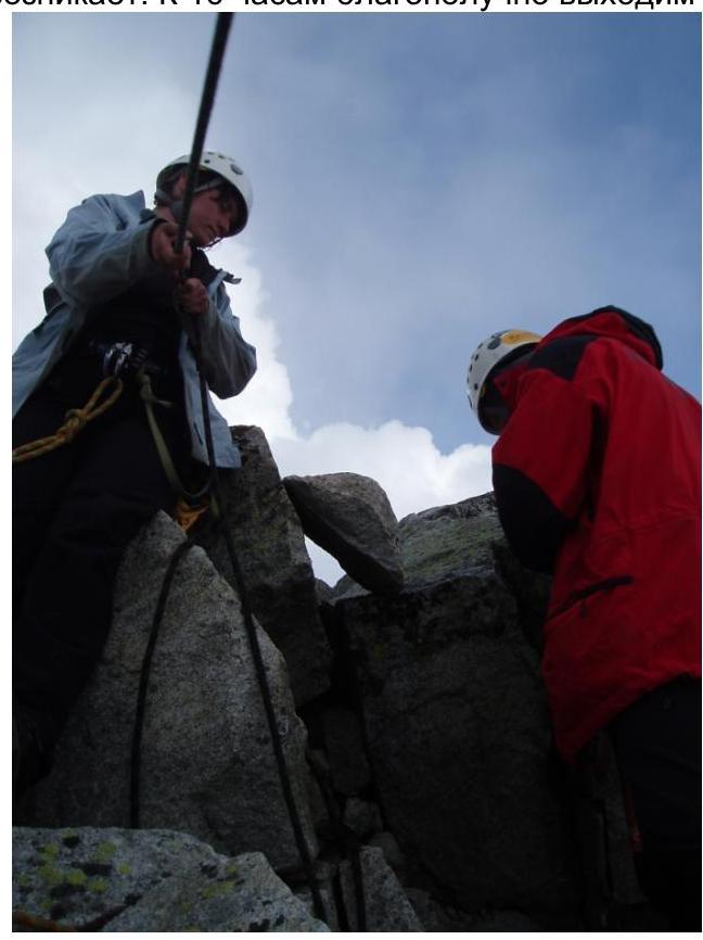
Eduard Rubtsov on section R2
The approach across the gentle and familiar glacier did not take much time. The dangerous icefall section was easily and quickly overcome.
At the start of the sixth hour, a small rock section — "ram's foreheads" — was passed. Before exiting onto the glacier, it was decided to rope up and continue with simultaneous belay.
The bergschrund at the upper part of the glacier was crossed via a snow bridge. By 7:00 AM, the group reached the randkluft under the wall, reaching an altitude of 3000 m according to the altimeter.
The randkluft was snow-clogged in one place, but the transition from snow to rock proved very challenging. From this point, Rubtsov Eduard began working first. Gubanov Dmitry closed the group.
Cold morning rocks, almost complete lack of relief at the very start of the route — a tough task. Over an hour was spent on overcoming the first 60 m of the wall.

According to the tactical plan, all participants were to climb the route using free climbing. Perches were only organized on the most complex sections. This was only possible with maximally lightened backpacks.
Meanwhile, the sun rose and illuminated the rocks, making climbing easier. The route began at the foot of the black rock and ascended, bypassing the rock on the left. Then, it traversed the stream bed and exited onto another section of "ram's foreheads."
The complexity of the first ropes lay in the following:
- Specifics of climbing "ram's foreheads": the steepness of these rocks is still far from vertical, but the relief is so poor that it requires masterful rock climbing technique to pass.
- In conditions of impoverished relief, it's very challenging to organize reliable belay.
- In the morning, such sections are often covered with ice, creating additional difficulties.
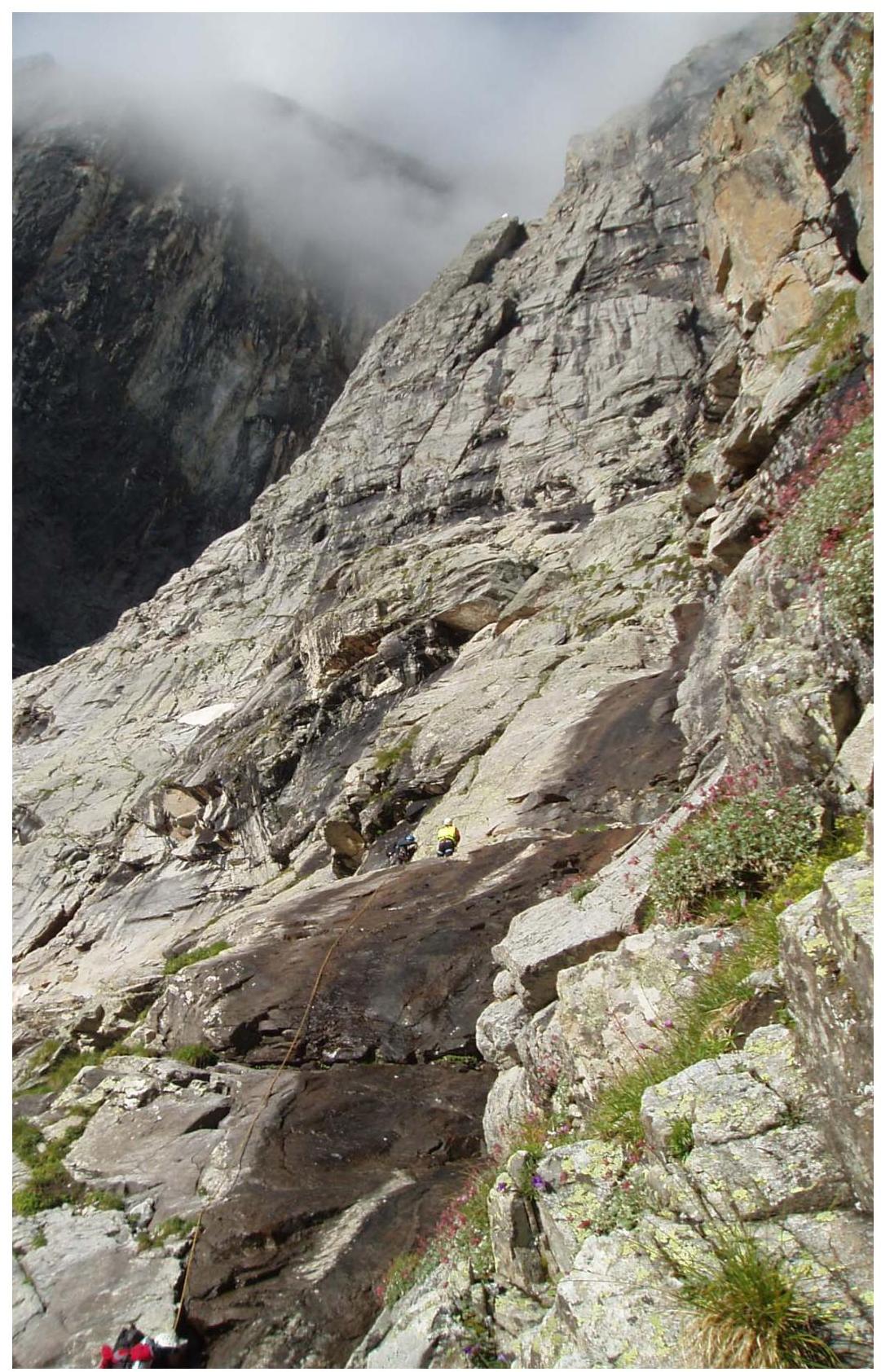
Sections R2–R3.
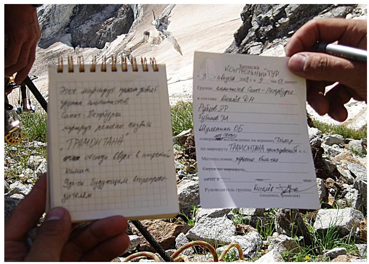
Note in the first control cairn
The "ram's foreheads" continue until section R4, until exiting onto a wide ledge. Along the ledge, it's necessary to traverse rightward to where the ledge widens. Here, a halt was made, and the first control cairn was built from stones. It was already around 10:00 AM. The weather was still fairly good.
From this point, the wall's relief changes sharply. Steepness increases, and the relief becomes more dissected. There are many loose rocks on rare ledges.
Our path:
- From the control cairn
- Straight up
- To the base of the chimney
We overcome complex yellow rocks with black streaks. Organizing belay points became easier, although it required caution. Eduard Rubtsov leads. It's not easy for him — the rocks in this section are sheer. Nevertheless, we pass this section fairly quickly and enter the base of the chimney.
Chimney
Here, new challenges await — the lower part of the chimney clearly overhangs. It's quite wide and flaring — using conventional chimney climbing techniques is impossible here. Eduard climbs along the right wall of the chimney; this side is more monolithic, but there are fewer places for belay here.
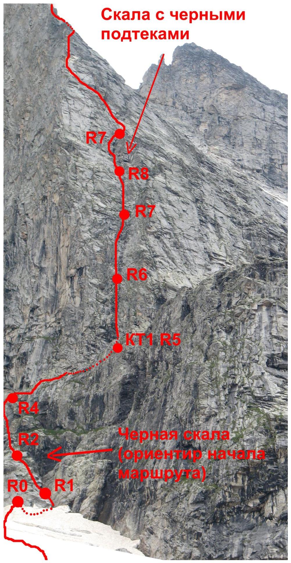
By 12:00 PM, three more ropes were passed. At this point, the chimney expands and becomes less steep. The route landmark, noted yesterday from below, is clearly visible — a square 5×5-meter yellow rock with black streaks, located to the right of the route. The pattern on the rock resembles a tiger's coloring, so we call it the "tiger wall."
The route line again sharply gains steepness. Just above the tiger wall, our chimney diverges into two gullies. We choose the left gully. It overhangs. In the upper part, the relief practically disappears; climbing is done via an overhanging crack on the left. Eduard uses artificial holds, and we set up perches. The crack ends on a ledge with loose rocks.
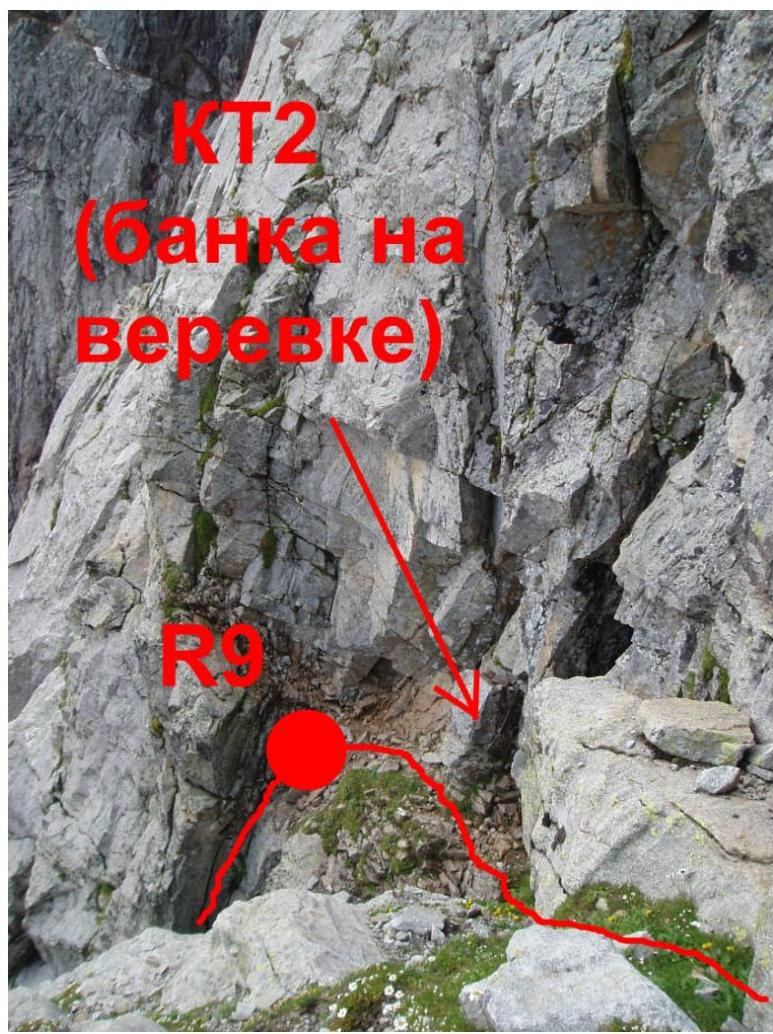
Second control cairn
Rock with Black Streaks (Route Landmark)
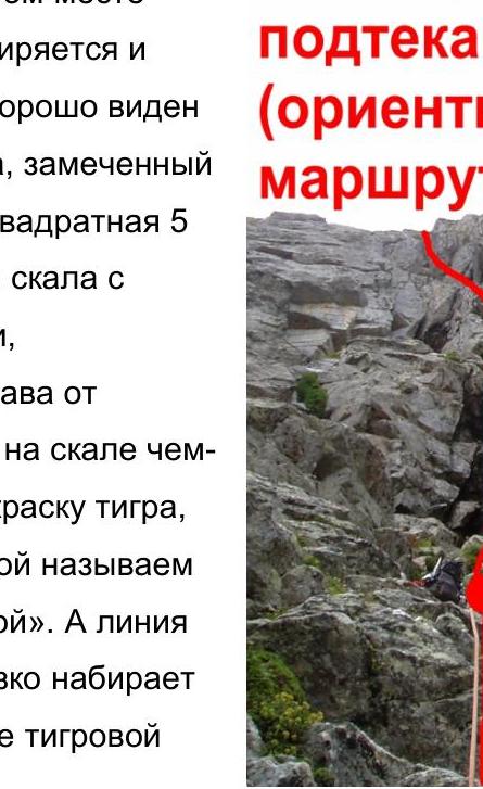 "Tiger Wall"
Ledge:
- narrow
- sloping upward to the right
- requires considerable effort not to dislodge rocks onto companions
Here, we set up the second control cairn — tie a rope with a can to a rock. The altimeter shows an altitude of 3325 m, and the clock shows 13:05.
We proceed along the ledge and climb upward again. The relief changes once more. Now it's:
- Rocks with gullies washed by water
- Or individual huge blocks standing on top of each other
Despite what was seen from below, the wall's steepness has not decreased significantly. Climbing remains very serious.
Traverse under cornices
The direction now is a huge rock-tooth, clearly visible and standing directly on the counterfort's summit. We bypass the rock on the right. The rocks are now more gentle; often we have to:
- climb over rubble
- navigate around separately lying boulders
- pick our way among debris
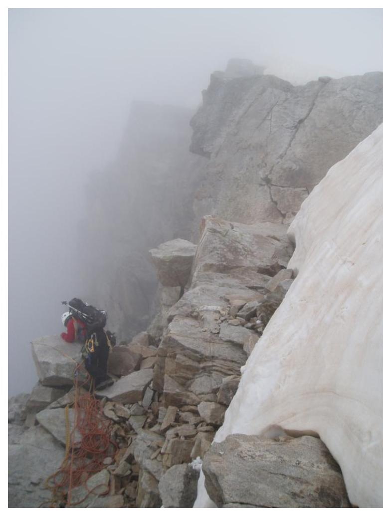
Meanwhile, the weather deteriorates; clouds descend. It's around 6:00 PM, and it's time to think about a bivouac. Everyone is very tired.
According to the tactical plan, the night's bivouac was planned above the second snow belt, but we haven't reached the first one yet. This was due to underestimating the real steepness of the upper part of the wall. Nevertheless, the main part of the wall is already behind us.
Finally, after another ascent, we reach a large snowfield. This is the first snow belt. Here, to the left of the snow, we lay out a platform and set up a bivouac.
As we organize the night's stay, it starts raining. Without managing to boil water, we hide in our "hideout." The tent quickly gets wet. Nevertheless, the rain soon stops, and the weather gives us time to prepare and eat something hot. It's cramped and damp in the sleeping bags, but after a hard day, we fall asleep quickly.
Weather worsens. Section R19
The night was clear and cold. Everything around is covered in frost. Gubanov Dmitry, who slept on the edge, froze significantly and slept poorly.
We're now significantly higher, and the first rays of the sun quickly warm us up.
After a light breakfast, we're ready to move on.
We put on crampons and pass the first snow belt. On the snow, Gubanov Dmitry leads. Reaching the randkluft at the upper part of the belt, we swap on the rocks; today, Kiselyov Denis works first. The first rock section is short but challenging — it leads to a section of "ram's foreheads" under the second snow belt.
Preparing a bivouac site
We traverse rightward and, after 200 meters, exit onto the pass between Shokoladny peak and Dalar. A short halt, and we're back on the move.
Now, we move to the side of the Myrdy valley and ascend along the osyp ledges toward Dalar's ridge. Climbing is not complex, but the distance to the summit tower is large, and despite our collective efforts, we only reach the ridge by 12:00, and the snow-ice ascent to the tower by 13:00.
From this point, the route line coincides with the Korablin route. The route is familiar, so no particular difficulties arise. By 16:00, we благополучно выходим на вершинный гребень, а в 16:50 — на саму вершину.
Summit
On Dalar that day, we meet a group from Stavropol; we exchange notes and impressions. They ascended via the Kavunenko route, 5A category, shortly before we reached the summit; a pair ascended via a 4th category route just before us.
Despite it still being fairly early, we decide not to go anywhere else that day and set up a bivouac in a rock niche slightly below the summit. As we settle in, the weather deteriorates again; it starts snowing. Trying to finish dinner as quickly as possible, we climb into our sleeping bags and attempt to sleep. Closer to midnight, a thunderstorm begins at the summit, but we're safely sheltered and are glad we didn't descend today.
The morning is again clear and cold. We quickly have breakfast, pack our backpacks, and begin our descent. The path is already familiar and doesn't present particular difficulties. We work smoothly on rappels. Within an hour, we find ourselves on the ridge at the base of the summit tower.
From here, we descend toward the Dalar pass, then onto the Myrdy glacier, and down into the valley to the Uzunkol alpine camp. We arrive at the camp only at 16:00. We check in with the person responsible for safety, relieved to have overcome such a complex and interesting route.

UIAA Symbol Route Diagram
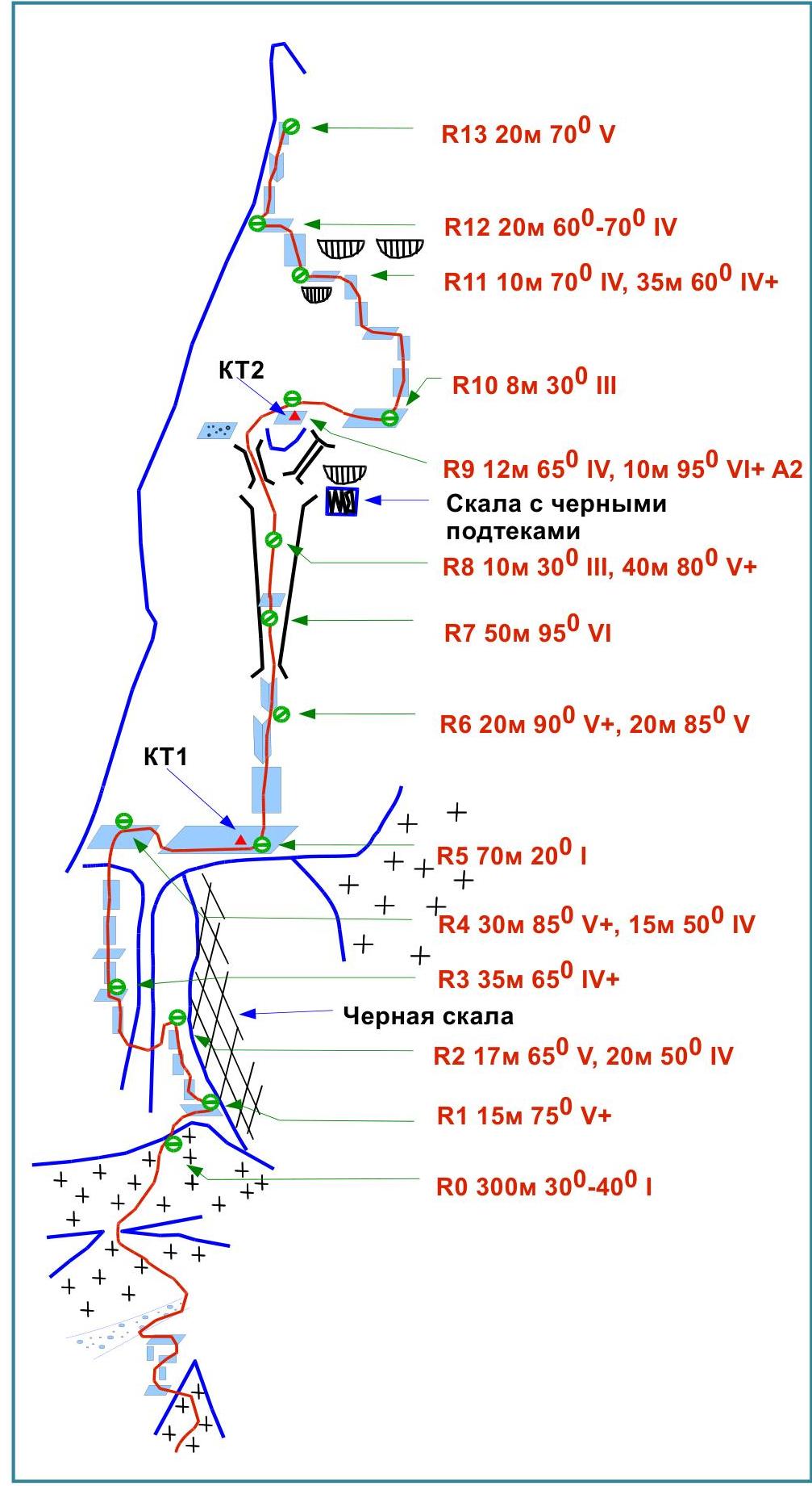
Lower part of the route
Middle part of the route
Upper part of the route. Summit tower
Route Profile
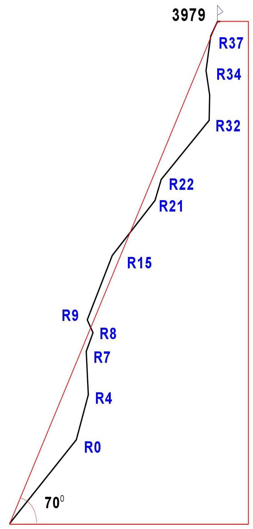
Route Description by Sections
From the bivouac in the right moraine pocket of the Big Kichkinekol glacier, move along the talus toward the moraine ridge, then along the right part of the glacier and upward to the right along a large snow cone. From the summit of the snow cone, turn left onto несложные «бараньи лбы». Be cautious, as there is a hanging glacier to the right, and icefalls are possible! From the "ram's foreheads," cross through an osyp kuлуар onto the glacier. Ascend along the некрутому льду in the direction of the северо-восточной стены. Bypass the bergschrund via a snow bridge (R0 300 m 30–40° I). From the bivouac, it takes 2 hours.
The route begins at a large internal angle formed by the black rock and "ram's foreheads" at the bottom of the wall.
Cross the snow-clogged randkluft onto the rocks and move rightward upward along complex rocks, exiting onto a ledge (R1 15 m 75° V+). On the ledge, a landmark at the start of the route — a empty gas cylinder hangs on the wall to the right. From the ledge, move leftward upward along smoothed slabs, bypassing the black rock. The cracks are deep, wet, and in bad weather, ice may form. Belay is challenging; anchor hooks were used (R2 17 m 65° V, 20 m 50° IV).
Approach and lower part of the route
Lower part of the route
Key section of the wall
Then move left through the stream bed and upward along smoothed, wet "foreheads" on the left side of the stream to a ledge (R3 35 m 65° IV+).
From here, ascend along the stream bed via a smooth, smoothed slab 85° V+ (R4 30 m 85° V+, 15 m 50° IV, organizing belay is challenging).
Exit onto a large osyp green ledge, along which traverse rightward to the control cairn (R5 70 m 20° I, movement is simultaneous). From the control cairn, upward along the rock with black streaks, bypassing the overhang at the base of the internal angle transitioning into a chimney (be cautious of loose rocks), and upward along the internal angle (R6 20 m 90° V+, 20 m 85° V, the station at the base of the chimney is inconvenient). The entrance to the chimney is through a slightly overhanging internal angle, which is passed along the right side (10 m 95° VI). Ascend the chimney. The chimney is wet, with moss on the rocks, few cracks, and belay is challenging; many loose rocks. Anchor hooks were used for organizing belay points. In the upper part, the chimney overhangs.
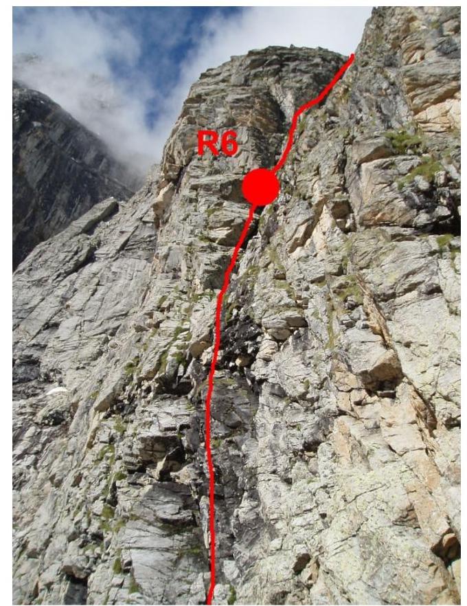
Rock with black streaks
After passing the overhang, there's a station R7 50 m 95° VI. Upward along the chimney through an osyp inclined ledge in the depth of the chimney — 10 m III. Loose rocks!!! And then 40 m V+. At this point, the chimney expands to 4 m. The next R8 station was organized on a large camalote and hex.
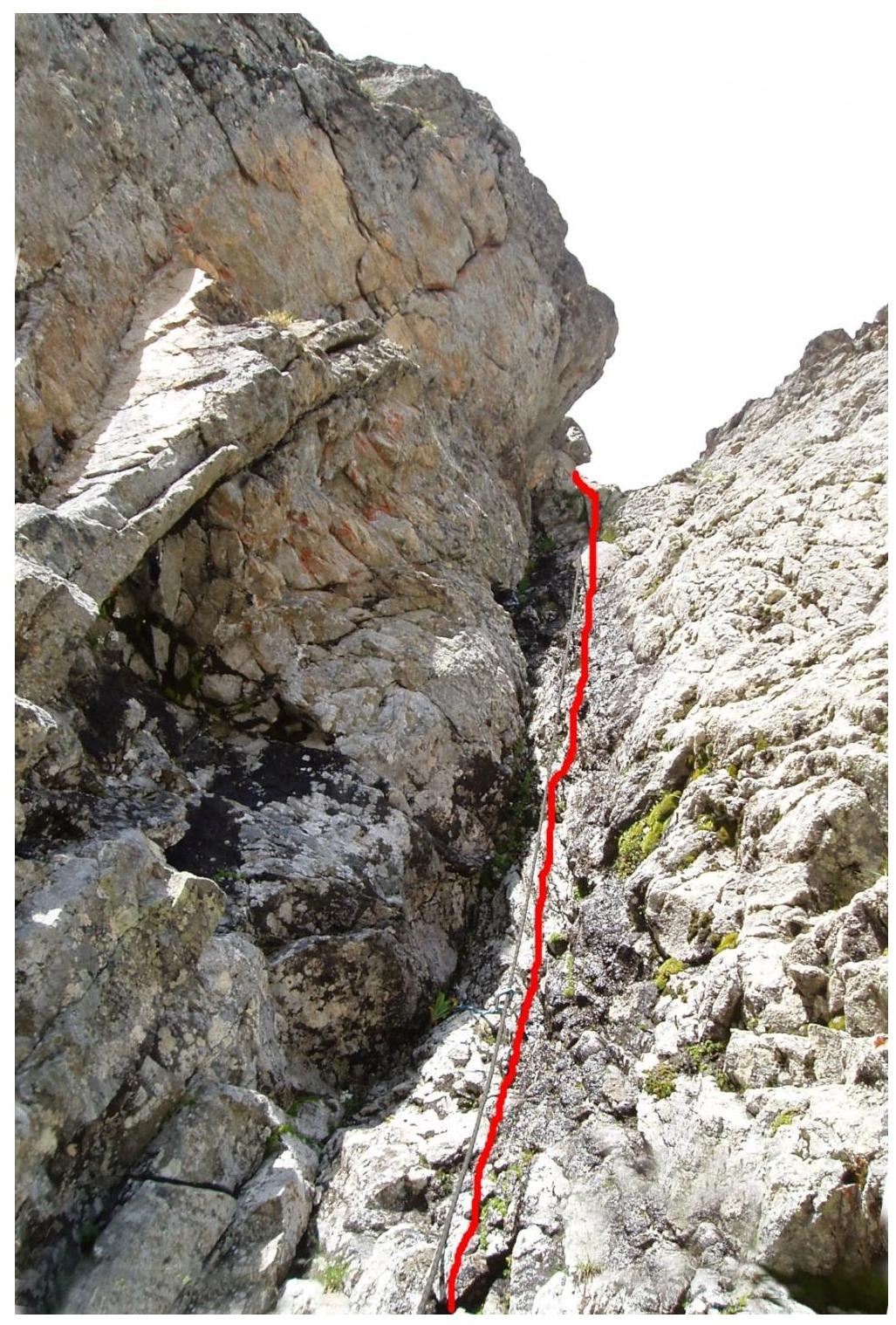
10 m upward to the right of the station, there's a wall with characteristic black streaks on yellow — a route landmark. Along the chimney upward, leaving the wall to the right, 12 m IV to where the chimney diverges. From here, along the left chimney upward to the left (95° VI+ A2). Loose rocks, water. The exit from the chimney is onto a steep ledge with many loose rocks. On the ledge, there's a control cairn 2 (a can on a loop). R9 12 m 65° IV, 10 m 95° VI+ A2.
Traverse along the ledge rightward upward R10 8 m 30° III. On the ledge, a sitting bivouac is possible. From the ledge, upward along a slab (10 m IV) and then along destroyed rocks leftward upward under yellow cornices. The relief in this section is characterized by separate standing blocks, slabs, and rocks. Continue movement toward the left edge of the wall. R11 10 m 70° IV, 35 m 60° IV+.
From the ledge R12, upward along internal angles and walls 70° V, 20 m. Upward toward a separately standing rock — a "tooth" on the summit of the northern counterfort. The rock-"tooth" is bypassed on the right along complex rocks. 5 m below the rock-"tooth" — a ledge for a sitting bivouac (R13 20 m 70° V, R14 22 m 75° IV–V, R15 35 m 75° V).
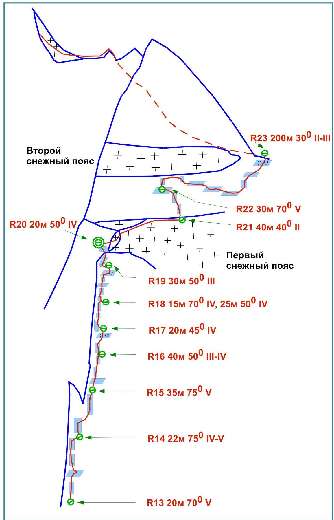
Above section R15, the route becomes more gentle and passes along various walls composed of loose rocks. The route line is not clearly expressed. The main recommendation is to stick to the left part of the wall. The osyp ledges encountered along the way are dangerous due to rockfall, and water flows along the rocks (R16 40 m 50° III–IV, R17 20 m 45° IV, R18 15 m 70° IV, 25 m 50° IV, R19 30 m 50° III, R20 20 m 50° IV). Section R20 leads to the first snow belt. On a ledge to the left of the snow — a platform for a bivouac.
Through the snow ledge, upward to the rocks and then traverse rightward along the randkluft 40 m to a rocky ledge (R21 40 m 40° II). From here, upward along sufficiently complex rocks (R22 30 m 70° V) to "ram's foreheads" under the second snow belt. Along the "ram's foreheads," along the boundary of snow and rocks, traverse 200 m rightward to the pass between Shokoladny peak and Dalar (R23 200 m 30° II–III).
Upper part of the route
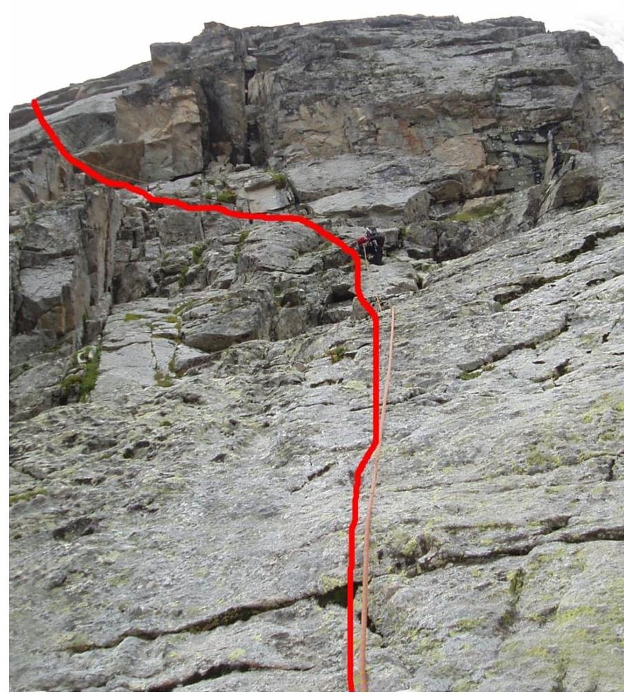
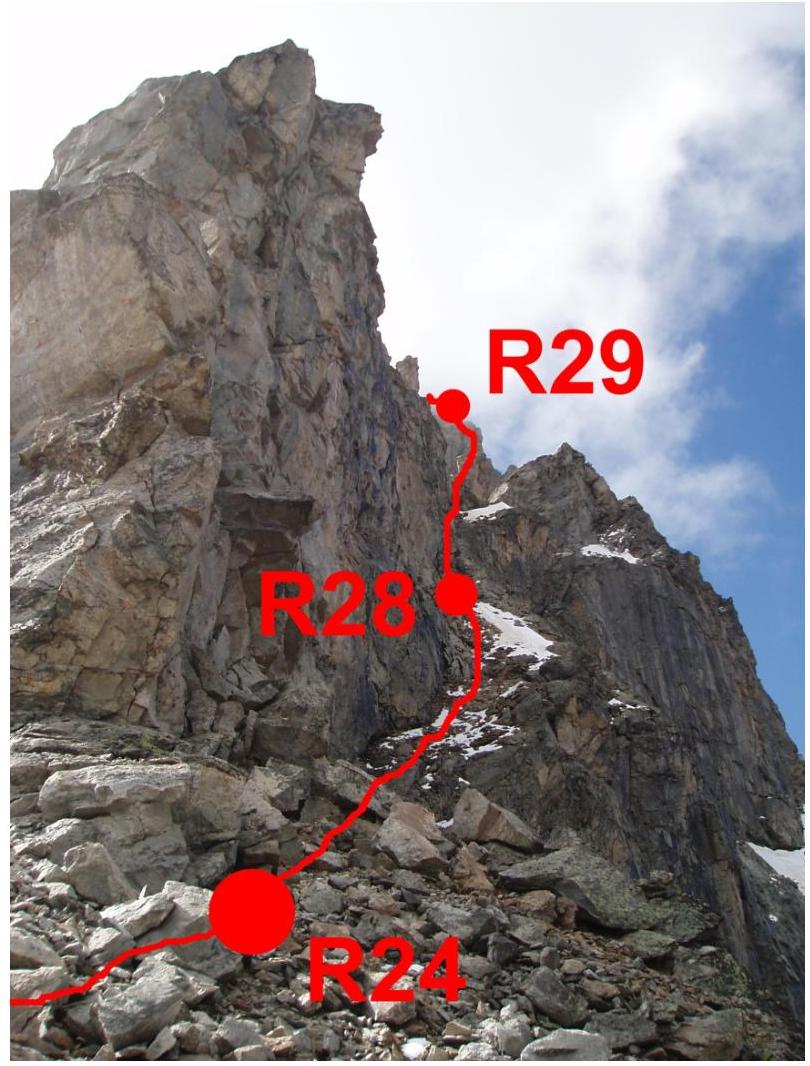
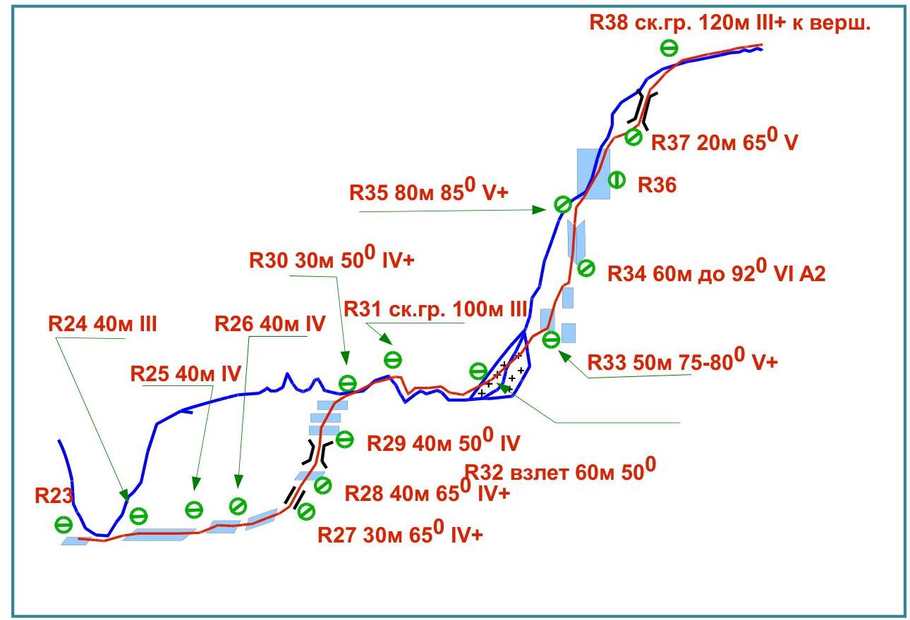
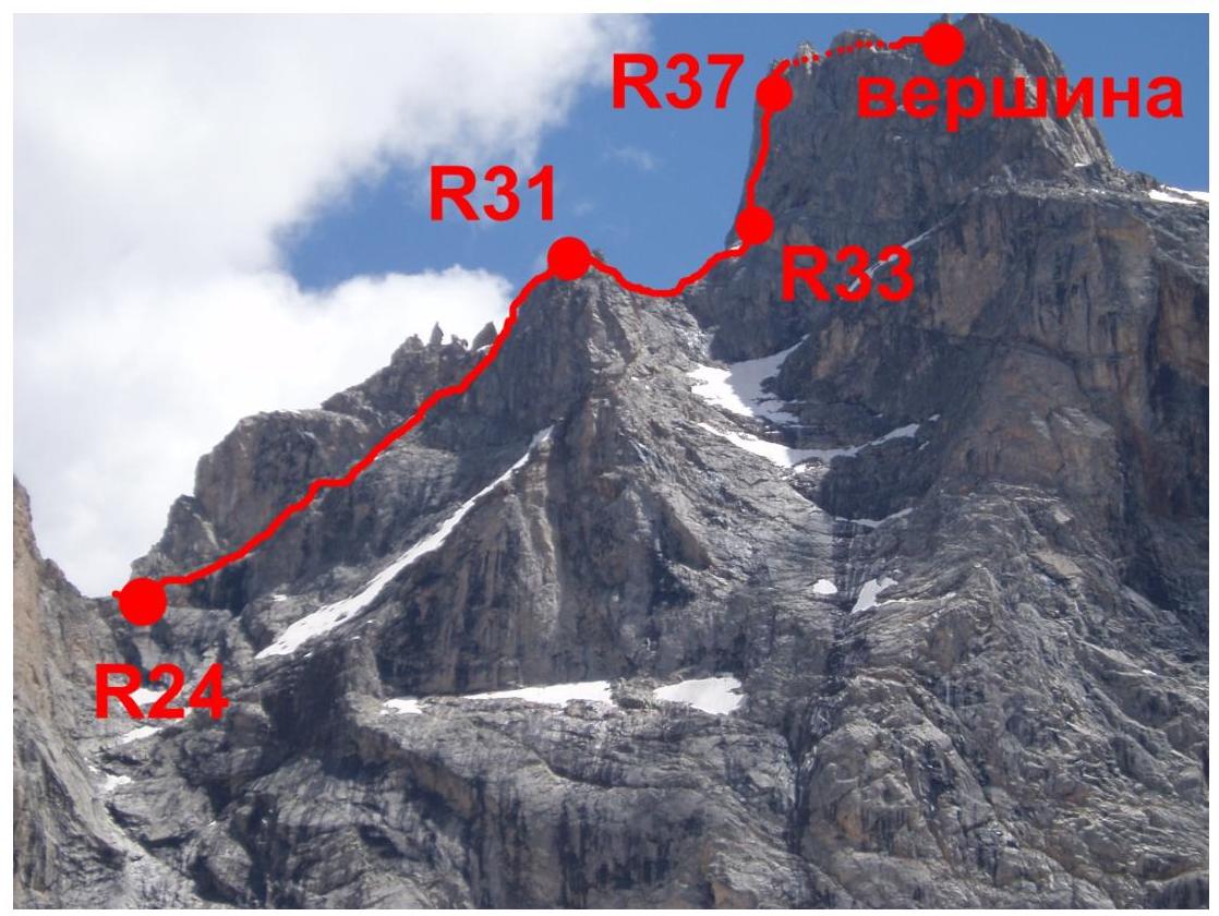
From the pass, having moved to the side of the Myrdy valley, ascend along a large osyp ledge toward Dalar peak (R24 40 m III, R25 40 m IV, R26 40 m IV, R27 30 m 65° IV+, R28 40 m 65° IV+, R29 40 m 50° IV). From the ledge, exit onto Dalar's ridge and then along the heavily dissected ridge toward the summit tower, bypassing jandarms (R30 30 m 50° IV+, R31 rock terrain 100 m III). Climbing is not complex but psychologically tense (sheer drops on both sides of the ridge).
From the exit onto the ridge, the route line further coincides with the route along the northeastern wall of the Northern shoulder (Korablin 5B). The rocks of the ridge lead to the ice ascent of the summit tower's edge. Here, there are platforms for a bivouac. Having overcome the ice ascent (R32 60 m 50° IV), move onto the steep rocks of the summit tower (R33 50 m 75–80° V+) and, moving first through a 60-meter internal angle (R34 60 m up to 92° VI A2), and then an 80-meter vertical wall with small holds (R35 80 m 85° V+) and a chimney (R37 20 m 65° V), exit onto the summit ridge, along which move toward the summit (R38 rock terrain 120 m III+).
From the summit, descend down an osyp kuлуар 20 m and, bypassing a rocky outcrop, exit to a grotto. Here, a place for the second planned bivouac. 10 m further along the ledge, there's a drilled rappel station — the start of the descent from the summit.
Descent from the summit is possible via the "Dalar from the south 3B" route or through drilled rappel stations from the "snow knife."
Descent path of the group from the Dalar pass
Equipment Table
| Item of Equipment | Quantity | Where Used |
|---|---|---|
| Main Rope | 3 pcs | R0–R39, on bivouac, on descent |
| Auxiliary Rope | 20 m | R0–R39, on bivouac, on descent |
| Carabiners | 60 pcs | R0–R39 |
| Rock Hooks | 5 pcs | R1–R9 |
| Anchor Hooks | 5 pcs | R1–R39 |
| Chocks | 60 pcs | R1–R39 |
| Rock Hammers | 2 pcs | R0–R39 |
| Loops, Quick |