PASSPORT
Ascent to v. Hokel via the Eastern ridge
-
Ascent class — rock climbing
-
Ascent area — Western Caucasus, Main Caucasian Range
-
Peak, route — v. Hokel, 3645 m, ascent via the Eastern ridge from the saddle between v. Hokel and the Nameless peak on the left.
-
Proposed difficulty category — 4B
-
Route characteristics: elevation gain — 700 m length of sections: II cat. diff. — 400 m II–III cat. diff. — 1400 m IV–V cat. diff. — 180 m average steepness — 45° (sections R3–R4)
-
Number of pitons hammered:
for belay for Aids rock 42 3 ice 1 — -
Number of travel hours — 27
-
Overnight stays: 1 — on the summit of the first ascent, rock platform on the ridge; 2 — on the moraine of the "Chotcha" glacier.
-
Leader and participants:
leader — CHERNYKH Yuri Nikolayevich — 1st sports category, instructor; participants: EGOROV Vladimir Ivanovich — 1st sports category; ES'KIN Vsevolod Afanas'evich — 2nd sports category; MIKHAILOV Oleg Vladimirovich — 2nd sports category, instructor; GUBIN Vyacheslav Vladimirovich — 2nd sports category.
-
Team coach — KLIMOV Gennadiy Alekseyevich, Candidate Master of Sports, senior instructor.
-
Date of departure on the route — August 22, 1977 return — August 24, 1977
Map of the ascent area

Description of the ascent
to the "Hokel" peak via the Eastern ridge from the "Hokel" glacier
From the camp at the Northern Priyut along the trail along the Hokel river to the Hokel glacier. Across the glacier to the bergschrund under the saddle between v. Hokel and the Nameless peak on the left (3 hours from the camp). Ascent up the saddle along a steep snow-firn slope (2 hours). From the saddle to the right along an easy ridge and along the ledges on the right (3 hours) to the base of the first ascent. Platform for a bivouac, control cairn.
Exit to the first ascent along a 20-meter wall (first 10 m up to the left, then 10 m up to the right) rock with "live" stones (difficult climbing, pitons).
Further up to the left 20 m along the rocks with a large number of holds to the base of the cleft-chimney. Up the chimney or along its left wall 15 m up (difficult climbing, pitons) to a sheer 15-meter wall with an internal angle. Up the wall, using the cleft at the base of the internal angle, straight up, then 3–4 m to the right onto a ledge under the feather-like rocks (wall with a small number of holds, very difficult climbing, pulling up backpacks). Along the feathers to the right, then along difficult rocks and rocks of medium difficulty 40 m up — exit onto the sharp ridge of the summit of the first ascent. Along the sharp ridge 40 m — exit onto a platform for a bivouac under the base of the second ascent. Control cairn. (6 hours from the base of the first ascent).
The first gendarme of the second ascent is passed straight on along rocks with a large number of holds (20 m). Then 40 m along a sharp steep ridge to a black sheer ascent, which is passed straight on (10 m) along monolithic rocks with a small number of holds. Then 20 m along a sharp ridge to the base of a light-gray ascent with reddish spots. Along rock (possibly snow-covered) ledges 20 m down to the right (piton belay), then up to the left onto the summit of the light-gray ascent 30 m along smooth monolithic rocks onto the ridge. Along a sharp ridge 15–20 m to the base of a wall with an overhanging rock. The lower 10 m of the wall — very difficult climbing using a ladder and pitons as points of support (7 m up to the right, 3 m up). Rocks are monolithic, overhanging with a small number of holds. Then 10 m up to the left along difficult rocks — exit onto the ridge. Along a sharp ridge of medium difficulty (60 m) — exit onto a pre-summit gentle ridge, 150–200 m along easy rocks and exit onto the summit. 5.5 hours from the base of the second ascent. Descent from the summit to the south along the route of 3B cat. diff.
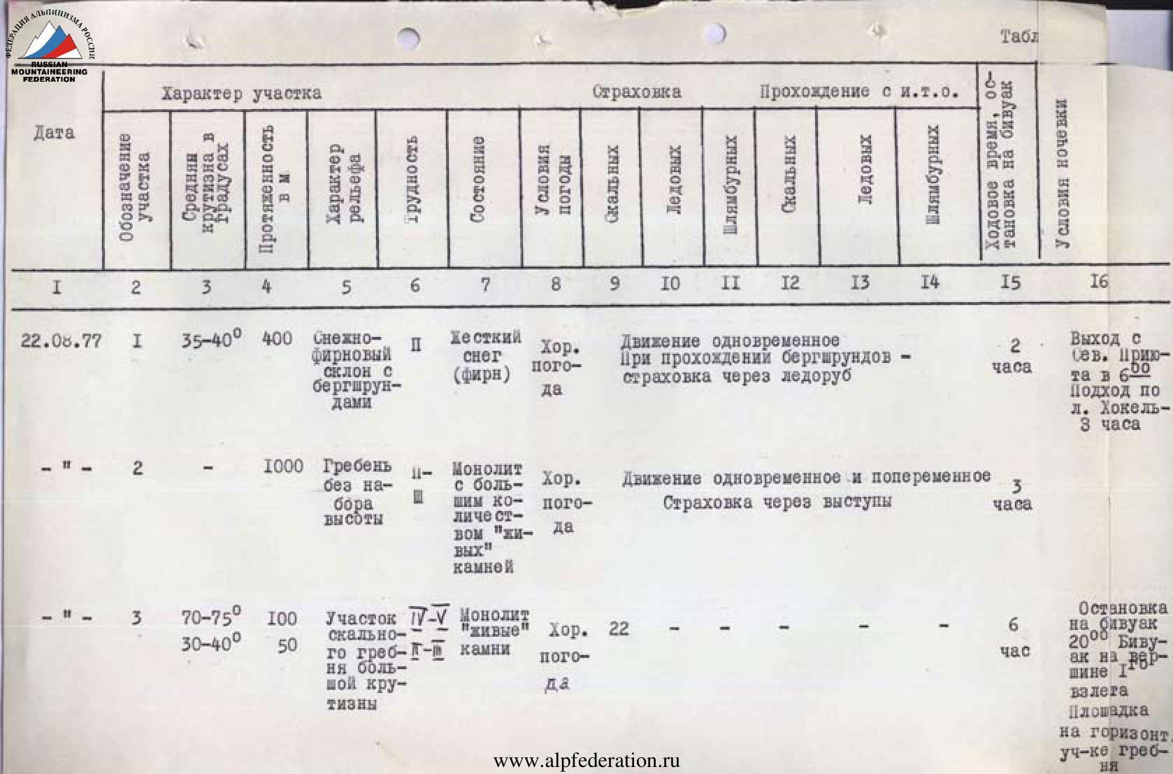
Table
| Date | Section designation | Average steepness, ° | Length, m | Relief character | Difficulty | Condition | Weather conditions | Rock belay | Ice belay | Bolt belay | Rock Aids | Ice Aids | Bolt Aids | Travel time / bivouac stop | Bivouac conditions |
|---|---|---|---|---|---|---|---|---|---|---|---|---|---|---|---|
| August 22, 1977 | R1 | 35–40° | 400 | Snow-firn slope with bergschrunds | 2 | Hard snow (firn) | Good weather | — | — | — | Simultaneous movement when passing bergschrunds — belay via ice axe | — | — | 2 hours | Departure from Northern Priyut at 6:00. Approach across Hokel glacier — 3 hours. |
| — " — | R2 | — | 1000 | Ridge without elevation gain | 2–3 | Monolith with a large number of "live" stones | Good weather | — | — | — | Simultaneous and alternating movement. Belay via outcrops | — | — | 3 hours | — |
| — " — | R3 | 70–75° 30–40° | 100 50 | Section of rock ridge with great steepness | 4–5 | Monolith, "live" stones | Good weather | 22 | — | — | — | — | — | 6 hours | Bivouac stop at 20:00. Bivouac on the summit of the 1st ascent. Platform on a horizontal section of the ridge. |
| August 23, 1977 | R4 | 70–75° 30–40° 10–30° | 80 150 200–250 | Rock ridge with sections of great steepness | 4–5 | Monolith, "live" stones | Good weather | 17 | — | — | 3 | — | — | 5.5 hours | Departure on the route at 8:00 |
| August 23, 1977 | R5 | — | — | Descent along the Southern ridge of v. Hokel onto the "Chotcha" glacier along the route of 3B cat. diff. | — | — | — | 3 | 1 | — | — | — | — | 5 hours | Bivouac stop at 19:00 on the moraine of the "Chotcha" glacier. |

