
Ascent Record
- Ascent level — technically challenging
- Ascent area — Western Caucasus
- Peak, its height, ascent route —
- Zapadnaya Klukhor-Kaya, 3500 m, via the northwest ridge
- Category of difficulty — 3B
- Route characteristics — height difference 800 m, average slope 40–45 degrees
- Total climbing hours — 16–18
- Overnight stay — on Hokkel Glacier
- Group composition:
- Khudak V.I. — leader
- Stepanov S.I. — participant
- Naumov S.F. — participant
- Kravchenko N.G. — participant
- Tkachenko D.S. — participant
- Team coach:
- Departure date — July 20, 1977
Return date — July 22, 1977
Description of the First Ascent
Ascent of Zapadnaya Klukhor-Kaya via the northwest ridge, category 3B. First ascent made by a group of instructors from the Dombay alpine camp:
- Khudak V.I. — leader, 1st sports category
- Stepanov S.I. — participant, II sports category
- Naumov S.F. — participant
- Kravchenko N.G. — participant
- Tkachenko D.S. — participant
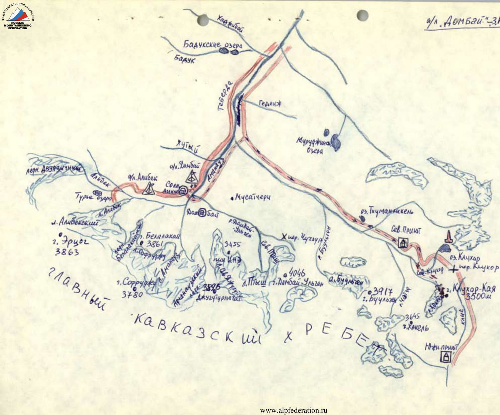
From the Northern Shelter, follow the trail towards Klukhor Pass to the memorial for fallen soldiers, then continue 200 m along the trail and veer right onto a less visible trail leading to Hokkel Glacier. Access the glacier via the right (orographically) moraine and proceed along the right side of the glacier to reach the snow slope below the northwest ridge of Zapadnaya Klukhor-Kaya. Overnight stay on the moraine of the glacier; the journey from the Northern Shelter takes 1.5–2 hours.
From the overnight campsite, ascend the snow slope, moving right and upwards to reach the green ledges of the northwest ridge. The ascent from the campsite to the green ledges takes 30–40 minutes (see R0–R1).
Traverse the green ledges right and upwards towards the "Green" chimney, which transitions into a crevice (two ropes). The chimney is bypassed on the right via the ledges (four ropes) to a large couloir that leads to the ridge (see R1–R2).
Cross the couloir below the lower plug and continue right and upwards via ledges and moderately difficult rocks to reach the ridge below the third ascent (see R3).
The third ascent is tackled head-on with piton protection (two ropes). Continue along the ridge to reach a 40-meter wall ("mirror"). Bypass the "mirror" at its base via a narrow green ledge to the left, then ascend 40–60 m via несложным скалам (easy rocks) to regain the ridge (see R4). Continue along the heavily serrated ridge to a gap (see R5) before a gendarme and descend to it via a grey diagonal ledge (on the left). Ascend from the gap via a 10-meter wall head-on (medium difficulty climbing with piton protection — two pitons) to regain the ridge.
Proceed along the ridge for two ropes to reach the "Rusty" gendarme (see R6), which is bypassed on the right via a green narrow ledge (10–15 m). Then move left along an inclined slab (5 m) onto the gendarme's shoulder and from there back onto the ridge. Continue along the sharp, eroded ridge to the "Black Tower" gendarme (see R7), from which a small ridge extends to the right.
The "Black Tower" gendarme is ascended head-on for 2/3 of its height:
- piton protection — 3 m to the shoulder;
- from the shoulder, move right along a crack into a gap on the ridge behind the gendarme.
Continue along the serrated ridge (four-five ropes) to inclined slabs (see R8) below a gendarme with a vertical crack (15–20 m high) — see R9. The inclined slabs are ascended with piton protection (two pitons) on the left and lead below the gendarme.
Bypass the gendarme on the right via rocks (one rope) to an inclined groove, which leads to a diagonal white rock ledge-platform (see R10) — a control point. This ledge is a potential overnight campsite. The journey from the moraine campsite takes 6–7 hours.
From the white ledge, ascend rocks of moderate difficulty, two ropes upwards to the pre-summit ridge (piton protection, three-four pitons). Continue along the ridge for two-three ropes via steep, sharp rocks to reach the summit of Zapadnaya Klukhor-Kaya (piton protection, two-three pitons).
The ascent from the campsite to the control cairn on Zapadnaya Klukhor-Kaya takes 8–9 hours.
Descend from the summit via the ascent route (two 40 m rappels) and continue via climbing to the white diagonal rock ledge (R10) with a control cairn. From the ledge, regain the ridge and bypass the gendarme (R9) on the left (in the direction of travel) via a ledge to the inclined slabs, then descend to a couloir on the right (in the direction of travel) — immediately behind the inclined slabs.
Descend the couloir (R12) — two 40 m rappels via heavily eroded rocks.
Continue right (in the direction of travel) for two ropes along an inclined ledge (piton protection — four pitons).
Then rappel 30 m (R13) onto the closed Klukhor-Kaya Glacier.
From the descent point onto the glacier:
- bypass crevasses,
- cross the glacier to the right (in the direction of travel) downwards,
- to the base of the right (in the direction of travel) ridge,
- onto the "ram's foreheads" (barranji lby).
Along the "ram's foreheads" and green ledges, veering left along the cirque of Klukhor-Kaya Glacier, descend to Hokkel Glacier to the overnight campsite.
The descent to the overnight campsite on Hokkel Glacier takes 4–5 hours. Approximately 20 pitons were used on the route, which takes around 13–15 hours from campsite to campsite on Hokkel Glacier.
Recommendations for climbers for a group of four:
- Main ropes — 40 m × 2;
- Quickdraws (moletki) — approx. 2 pcs;
- Pitons — approx. 12–15 pcs;
- Expendable cordelette — 10 m.
Bypass the first two ascents only on the right via the ledges to the 3rd ascent.
Character of Sections
| № | Section | Average slope | Length, m | Terrain character | Category of difficulty | Condition | Weather conditions | Rock pitons | Ice pitons | Bolts |
|---|---|---|---|---|---|---|---|---|---|---|
| R0–R1 | R0–R1 | 35–40° | 400 | rocks | 2–3 | monolithic | clear | – | – | – |
| R1–R2 | R1–R2 | 40° | 170 | ledges | 3 | rocky | – | – | – | – |
| R2–R3 | R2–R3 | 45° | 90 | couloir | 3 | rocky | – | – | – | – |
| R3–R4 | R3–R4 | 50° | 130 | rocks | 3–4 | monolithic | – | 2 | – | – |
| R4–R6 | R4–R6 | 45° | 100 | ridge, wall | 3–4 | jagged rocks | – | 2 | – | – |
| R6–R7 | R6–R7 | 35° | 60 | ledges, gendarme | 3 | rocks | – | – | – | – |
| R7–R8 | R7–R8 | 60° | 140 | gendarme, ridge | 3–4 | eroded rocks | – | 3 | – | – |
| R8–R9 | R8–R9 | 30° | 45 | inclined slabs | 3 | monolithic | – | 2 | – | – |
| R9–R10 | R9–R10 | 45° | 50 | groove | 3 | rocky | – | – | – | – |
| R10–R11 | R10–R11 | 60° | 120 | ridge | 3–4 | steep, sharp rocks | – | 5 | – | – |
| R11–R12 | R11–R12 | 60° | 150 | – | 3 | – | – | 1 | – | – |
| R12–R13 | R12–R13 | 70° | 120 | couloir, inclined ledge | 3 | heavily eroded rocks | – | 4 | – | – |
| R13 | R13 | 90° | 30 | rocks | 3 | monolithic | – | 3 | – | – |
Comments
Sign in to leave a comment