
Ascent Passport
- Class — rock climbing
- Area — Main Caucasian Range, from Marukh pass to Nakhar pass
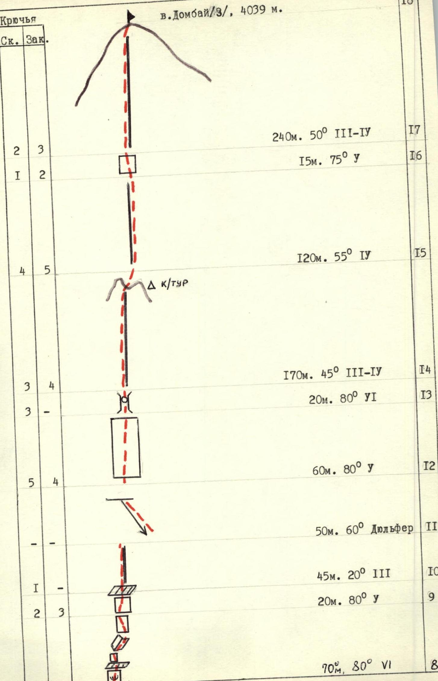
- Peak — Dombay (3), 4039 m, via Western counterfort.
- Proposed difficulty category — 5B
- Route characteristics: elevation gain: 1470 m, length of sections with 5–6 cat. diff. 315 m, average steepness 55°
- Pitons driven: rock (including chocks) — for belay — 94
- Climbing hours — 27
- Overnight stops — two, lying down
- Team composition: Chuenko S.K. CMS, team leader Nedelkin V.I. CMS, participant Yankov A.Yu. 1st sports category — — Yanchenko V.V. 1st sports category — —
- Team coach: Andryushchenko A.V., Master of Sports of the USSR
- Departure to the route July 5, 1983.
Return July 8, 1983.
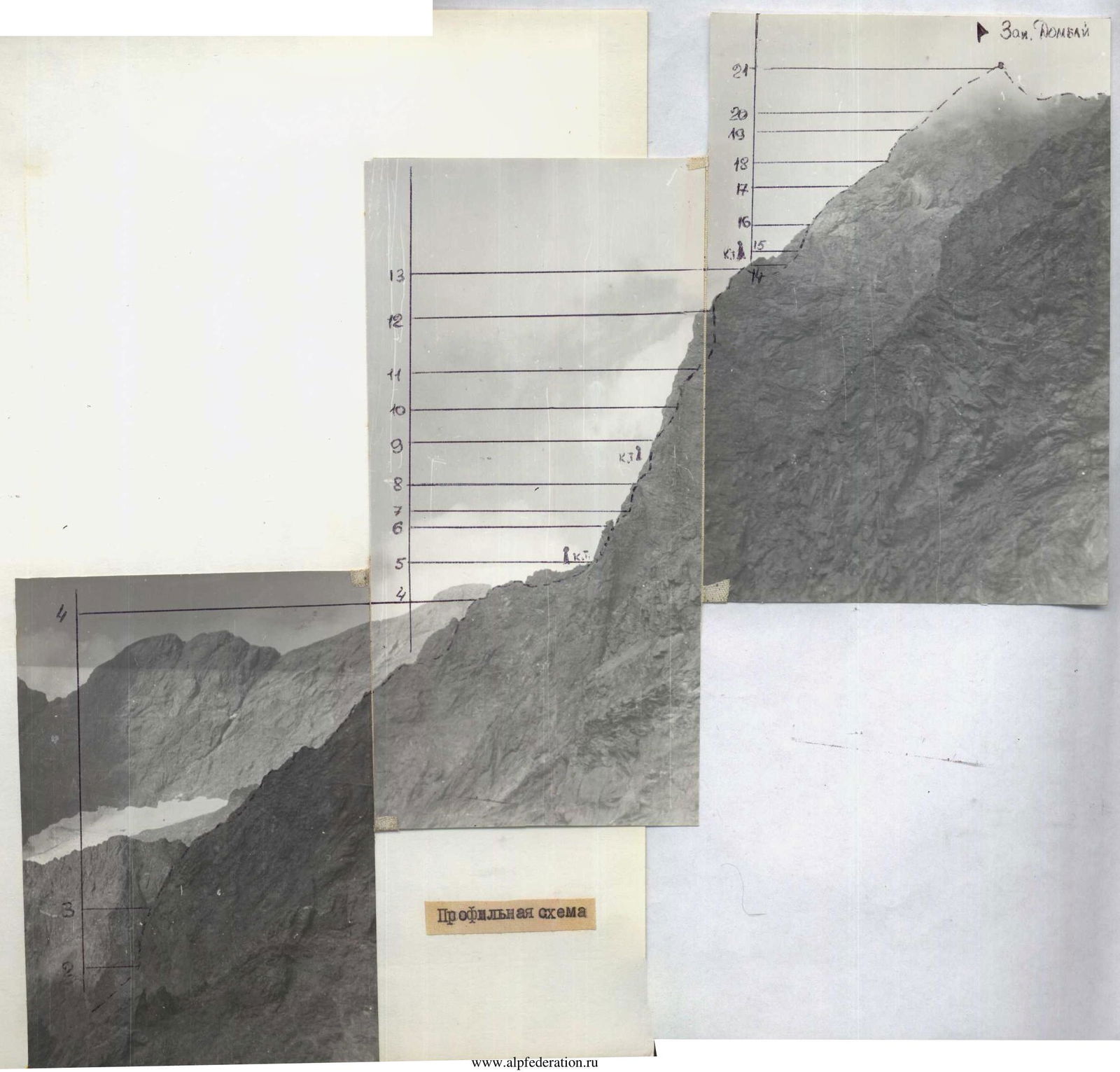
General view of the peak
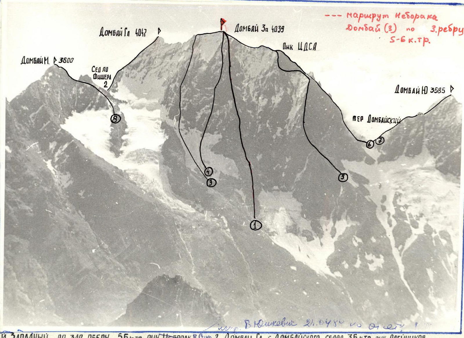
- Dombay West via West ridge, 5B cat. diff., led by Neborak V. (Sukha)
- Dombay Main from Dombay Saddle, 3B cat. diff., led by Aleynikov
- Dombay West via NW slope, 5B cat. diff., led by Pvovoy
- Dombay West via center, 3B cat. diff., led by Genchina S.
- Dombay West Peak from West, 4B cat. diff., led by Sasarov V.
- Dombay West from Dombay-BA pass
- Dombay from Dombay-Zak pass, Budanov V. (Dombay 1 from Dombay Saddle, 2B)
Route: ascent to Dombay West Peak via West ridge, 5–6 cat. diff., 4039 m
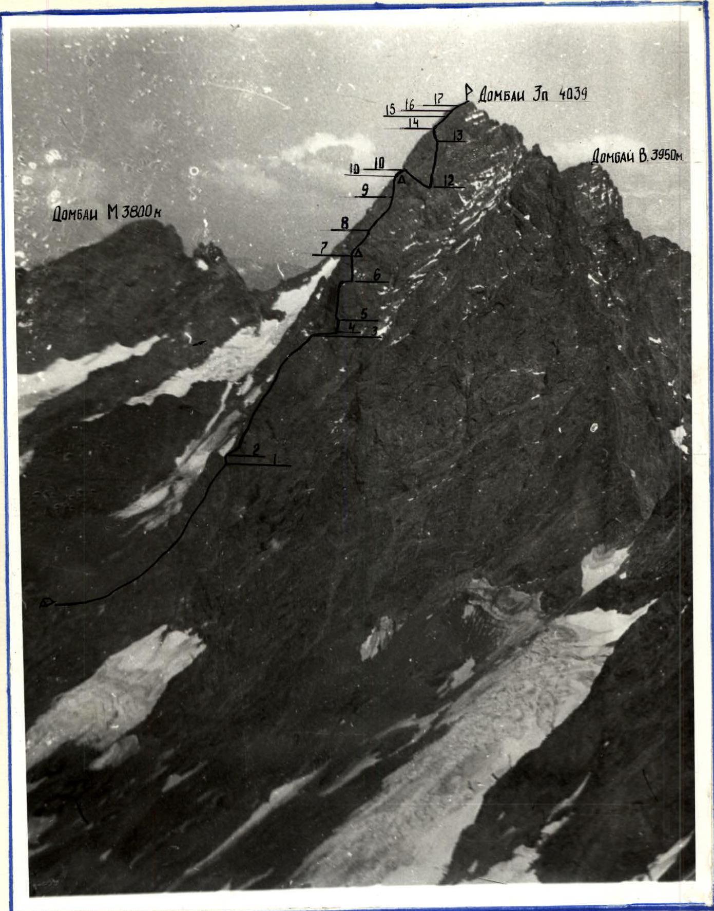
- Ascent route (Δ)
- Overnight stops
Table of main route characteristics

| Section designation | Average steepness | Length, m | Terrain character | Difficulty | Condition | Weather conditions | Rock Pitons | Chocks | Climbing style | Notes |
|---|---|---|---|---|---|---|---|---|---|---|
| R0–R1 | 45 | 200–220 | ledges | 2–3 | broken rock | clear | - | - | free climbing | Departure at 6:00. |
| R1–R2 | 75 | 5 | slab | 5 | monolith | — | 1 | - | — | |
| R2–R3 | 45 | 250 | ridge | 3–4 | broken rock | — | 2 | - | — | |
| R3–R4 | 10 | 40 | ledge | 2 | — | — | - | - | — | |
| R4–R5 | 80 | 20 | wall | 5 | blocky | — | 4 | 1 | — | |
| R5–R6 | 65 | 55 | walls, ledges | 5 | broken rock | cloudy | 4 | 4 | — | |
| R6–R7 | 55 | 140 | ledges, inner corner | 4 | — | rain, thunderstorm | 7 | 5 | — | Stopped for overnight at 17:00 due to bad weather. |
| R7–R8 | 80 | 50 | cornice, crack | 6 | icy rock | fog | 4 | 6 | — | Departure at 9:00 due to bad weather. |
| R8–R9 | 85 | 70 | cornice, inner corner | 6 | wet rock | fog, rain | 8 | 5 | — | |
| R9–R10 | 80 | 20 | wall | 5 | — | — | 2 | 3 | — | Overnight stop at 16:00. |
| R10–R11 | 20 | 45 | ridge | 3 | snow-covered rock | clear | 1 | - | — | Departure at 9:00. |
| R11–R12 | 60 | 50 | wall | — | "tiles" | — | - | - | rappel | |
| R12–R13 | 80 | 60 | wall | 5 | — | — | 5 | 4 | free climbing | |
| R13–R14 | 80 | 20 | chimney | 6 | monolith | — | 3 | - | — | |
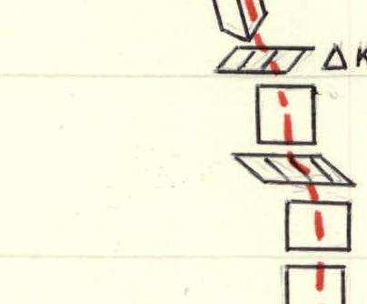
| R14–R15 | 45 | 170 | ridge | 3–4 | broken rock | — | 3 | 4 | — | |
| R15–R16 | 55 | 120 | ridge | 4 | — | — | 4 | 5 | — | |
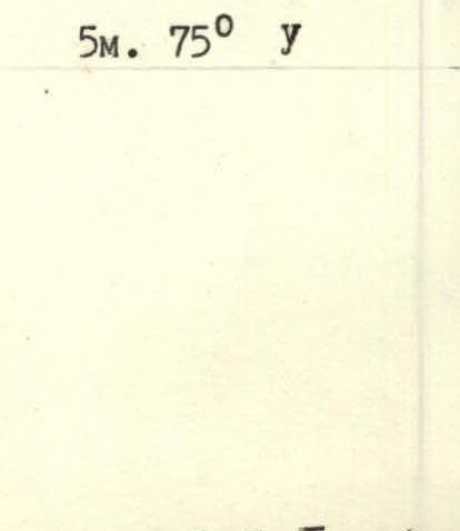
| R16–R17 | 75 | 25 | spall | 5 | monolith | — | 1 | 2 | — | |
| R17–R18 | 50 | 240 | ridge | 3–4 | broken rock | fog | 2 | 3 | — | Reached the summit at 17:50. |
Ascent route description
July 5, 1983: Departure to the route at 6:00. The start of the route is clearly defined. Overnight stop is possible within 10–15 minutes' walk from the beginning of the route.
Along easy broken rock of the ridge to the "Big Gendarme" 220–200 m (R0–R1). Bypassing the gendarme on the right via an easy ledge, exit to a 5-meter smooth slab with a chimney. Climb up the chimney to reach the ridge. Climbing is difficult (R1–R2). Along the ridge 250 meters of moderately difficult rock climbing to a large gap (R2–R3). From the gap, traverse right 40 m along a distinct ledge under a 20-meter wall. Climb up the difficult wall (blocky structure) to reach the ridge (R4–R5). Further along a narrow 20-meter ridge to the first ascent of the second third of the route. The ascent is made on the right side via difficult rock climbing with a steepness of 65° (55 m). Not reaching 3–4 meters to the shoulder of the right ascent, an overnight stop is possible in a rock niche (for 1 tent). On the shoulder of the ascent is a control point.
Further along moderately difficult rock (R6–R7) 140 meters — exit to the base of the second ascent. Here the group was caught by bad weather and had to stop for an overnight stop.
July 6, 1983: Weather is bad, fog, rocks are icy, started moving at 8:00. Through a small 1.5-meter cornice right-up 10 meters, and then left-up along a narrow inclined crack 40 meters to the ridge (R7–R8). Climbing is very difficult, 6B. Further right-up through a small overhang along a steep 80° wall 25 meters to a small ledge for one person. Further 5 meters of very difficult climbing (6B) to the base of an oblique overhanging inner corner. Along it right 10 meters and then straight up 20 meters to a narrow ridge crest. Climbing is very difficult (R8–R9). From the crest straight up 5 m, and then left-up 15 meters along difficult rock to the ridge (R9–R10). The group stopped for an overnight stop.
July 7, 1983: Along the ridge via moderately difficult rock 40 m to the base of the gendarme "Beak", which is a narrow crest. Above are overhanging rocks with "tiles" (R10–R11). From the crest, rappel down obliquely (about 45°) 40 meters and then straight up 60 meters of difficult climbing under a chimney with a plug in the right part of the gendarme "Beak" (R12–R13). Up the chimney 20 meters of very difficult climbing — exit to the ridge (R13–R14).
Further along the ridge with moderate difficulty 170 meters to a gate formed by two adjacent gendarmes. At the base of the gendarmes is a control cairn. Place for an overnight stop.
Further along moderately difficult rock 120 meters to a steep spall (R15–R16). Exit to the spall on its right part:
- 20 meters of difficult climbing (R16–R17);
- further to the ridge. Place for an overnight stop.
Further 250 meters along the broken ridge — exit to the summit. Descent from the summit via a route of 4–5 cat. diff. through Pik TsDSA or traverse to Dombay (Main) and further to Dombay Saddle via a route of 3–5 cat. diff.
| Rock Pitons | Chocks |
|---|---|
| 4 | 6 |
| 7 | 5 |
| 4 | 4 |
| 4 | 1 |
| - | - |
| 2 | - |
| 1 | - |
50 m, 80° (VI)
55 m, 65° and 20 m, 80° and 40 m, 10° (II)
250 m, 45° (III–IV) 5 m, 75°
Comments
Sign in to leave a comment