
MAIN CHARACTERISTICS TABLE OF THE SECTION
| Date | Designation | Average steepness | Length | Relief character |
|---|---|---|---|---|
| 28 August 1980 | 0–1 | 35 | 200 | Sheep's backs |
| Entered the route at 7:00 | 1–2 | 45 | 300 | Ridge |
| 2–3 | 80 | 40 | Internal corner | |
| 3–4 | 70 | 240 | Counterfort | |
| Set up for the night at 18:00 | 4–5 | 45 | 80 | Ridge, shelves |
| 29 August 1980 | 5–6 | 90 | 40 | Wall |
| Started the route at 8:00 | 6–7 | 50 | 30 | Narrow ridge |
| Overnight stay was bivouac | 7–8 | 90 | 40 | Wall |
| 1st control tour on the bivouac | 8–9 | 80 | 80 | Counterfort |
| 9–10 | 45 | 40 | Slabs | |
| 10–11 | 75 | 35 | Internal corner | |
| 11–12 | 90 | 45 | Internal corner | |
| 12–13 | 65 | 40 | Ridge | |
| 3rd control tour | 13–14 | 75 | 35 | Slabs |
| 14–15 | 80 | 40 | Slabs | |
| 15–16 | 90 | 40 | Chimney with a plug | |
| 16–17 | 75 | 45 | Wall | |
| Set up for the night at 18:00 | 17–18 | 70 | 40 | Ridge |
| 30 August 1980 | 18–19 | 80 | 90 | Wall |
| Overnight stay was bivouac | 19–20 | 95 | 35 | Crevice |
| 3rd control tour on the bivouac | 20–21 | 60 | 200 | Ridge |
Route characteristics 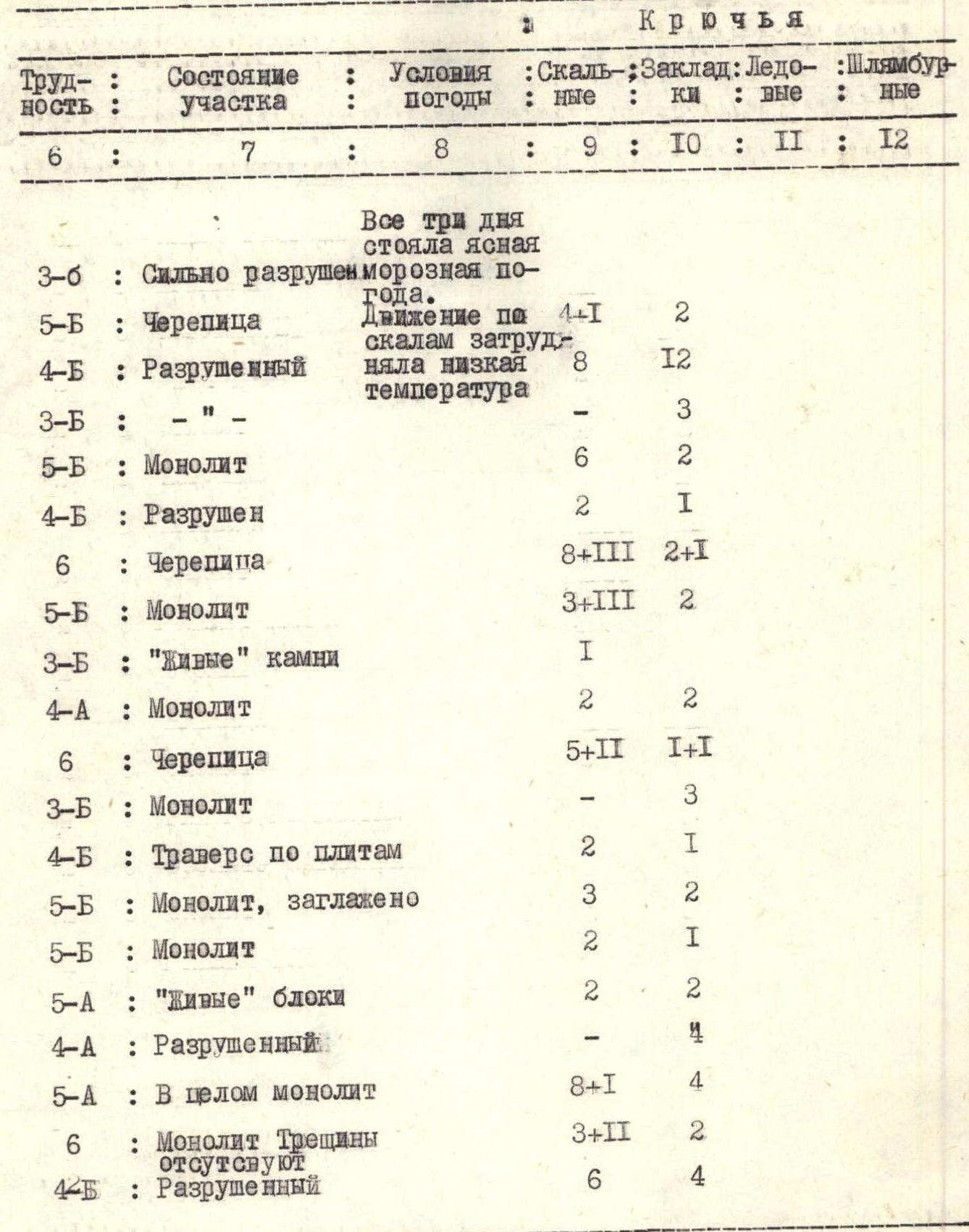
ROUTE CHARACTERISTICS
| Difficulty of the section | State of the section | Weather conditions | Rock pitons | Nut placements | Ice screws | Bolt pitons |
|---|---|---|---|---|---|---|
| 3 | Highly destroyed | All three days had clear frosty weather. | 4+1 | 2 | ||
| 5 | Tile-like | Movement on rocks was hampered by low temperature | 2 | |||
| 4 | Destroyed | 8 | 12 | |||
| 3 | – | 3 | ||||
| 5 | Monolithic | 6 | 2 | |||
| 4 | Destroyed | 2 | 1 | |||
| 6 | Tile-like | 8+3 | 2+1 | |||
| 5 | Monolithic | 3+3 | 2 | |||
| 3 | "Live" stones | 1 | ||||
| 4 | Monolithic | 2 | 2 | |||
| 6 | Tile-like | 5+2 | 1+1 | |||
| 3 | Monolithic | 3 | ||||
| 4 | Traverse on slabs | 2 | 1 | |||
| 5 | Monolithic, smoothed | 3 | 2 | |||
| 5 | Monolithic | 2 | 1 | |||
| 5 | "Live" blocks | 2 | 2 | |||
| 4 | Destroyed | 4 | ||||
| 5 | Generally monolithic | 8+1 | 4 | |||
| 6 | Monolithic. No cracks | 3+2 | 2 | |||
| 4 | Destroyed | 6 | 4 |
Explanations for the main characteristics table of the route
0–1. Highly smoothed rocks, not very steep. Many loose stones.
1–2. Exit to the ridge via a short but steep wall. Then along the ridge straight up, to the base of a large "gendarme" resembling a rider. The "gendarme" is bypassed on the left. Rocks are heavily destroyed.
2–3. Internal corner leads to a saddle between the "gendarme" Rider and counterfort. The first 15 m of climbing the internal corner are very difficult. The tile-like structure of the rocks poses a great danger. The upper part of the internal corner is destroyed. There are few cracks for pitons.
3–4. Straight up the counterfort. The first two 30-meter walls are climbed "head-on". Rocks are heavily destroyed in places.
4–5. The "gendarme" is bypassed on the right via a shelf when exiting to the depression of the counterfort under the big wall. A good site for overnight stay is available before reaching the depression. Here is the first control tour. We found a note from the group that made the second ascent of the route - a group of instructors from "Alibek" alpine camp: Abukov A. — leader, Khamtsov A., Gosman V. dated July 20, 1980.
5–6. From the depression, 30 m to the right along the shelf and then 40 m straight up the wall. Exit to the shoulder of the wall. Climbing is difficult.
6–7. The shoulder of the wall is a sharp, unstable ridge that abuts against a sheer 40-meter wall.
7–8. This is one of the most challenging parts of the route. There are overhangs in two places; the rock is heavily destroyed, and there are practically no good cracks for pitons and nut placements.
8–9. The wall leads to a good site under a steep counterfort of the ridge. Here, in a niche, is the second control tour of the first ascenders. We found a note from Abuukov's group that made the second ascent. The first 10 m of the counterfort are climbed with the help of artificial aids (IT). The rocks are strong, monolithic.
9–10. An easy rope length on slabs of a steep ascent of the ridge. A good landmark is constantly visible - high above, near the flattening of the ridge, a "gendarme" in the form of a bird's beak stands out.
10–11. Straight up a weakly expressed corner - exit to a wide shelf under an overhanging wall.
11–12. The 5-meter overhang is climbed with difficult moves from left to right. There are no cracks for pitons. Exit to a sloping slab - this is the key point of the route. It is climbed with complex moves, using ITO in places.
12–13. Then along a 40-meter easy ridge to the base of the "gendarme" Beak. Here is a place for overnight stay and the 3rd control tour of the first ascenders. We found a note from Abuukov's group.
13–14. Above the "gendarme" Beak, the ridge abuts against an overhanging, tile-like, impassable wall. To bypass it, it is necessary, without reaching the "gendarme" Beak, to traverse to the right along smooth slabs for 40 m.
14–15. After traversing 40 m to the right and up - difficult climbing on smoothed rocks to a wide shelf under the base of a sheer chimney with a plug in the middle.
15–16. The chimney is climbed by free climbing.
16–17. The wall on the ridge is climbed with difficult moves on the left side of the ridge. "Live" rock blocks.
17–18.
18–19. The 80-meter wall is climbed by free climbing. Rocks are monolithic.
19–20. Monolith. Practically no cracks. Climbing is very difficult; a crevice leads to the summit ridge.
20–21. The summit ridge is heavily destroyed. Climbing is difficult in places.
Descent from the peak Western Domбай-Ulgen via route 4B (Sasorov's path).
The western counterfort on Western Domбай-Ulgen was first ascended in August 1974 by a group of instructors from "Alibek" alpine camp: Sukharev V. — leader, Neborak V., Volkov A.
The second ascent of the route was made in July 1980 by a group of instructors from "Alibek" alpine camp: Abuukov A. — leader, Khamtsov A., Gosman V.
Comments
Sign in to leave a comment