The first championship of the alpinism club "Vertikal", rock climbing category.
Report
On ascending v. DOMBAI ZAPADNY (4036 m) via the left part of the western wall. Team from Togliatti branch of the "Vertikal" club. First ascent.
Team captain:
Team coach:
1989
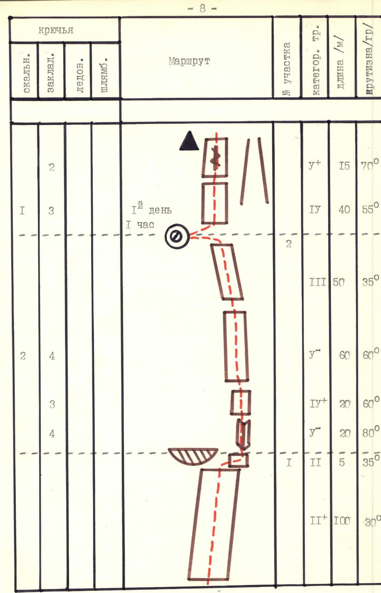
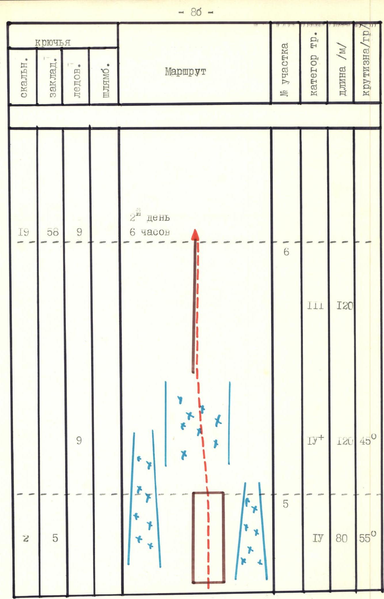
Route scheme in UIAA symbols. Scale 1:2000

Route scheme in UIAA symbols. Scale 1:2000
Route scheme in UIAA symbols. Scale 1:2000
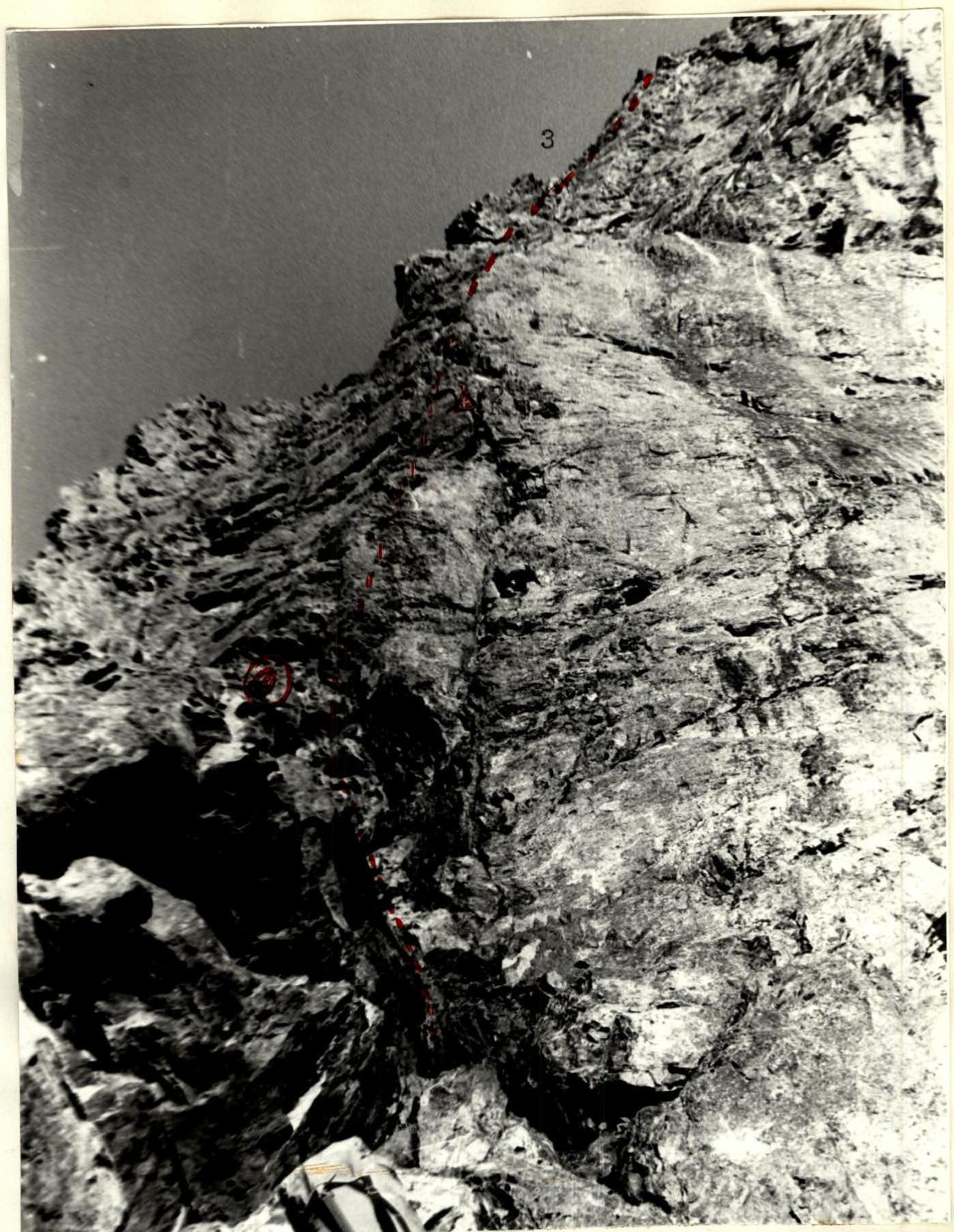
Photo 4. Section 2–3. Taken on August 3, 1989 at 15:00. Lens F=28 mm, shooting height 3250 m, distance to object 0.5 km.
Ascent details
- Russia. Western Caucasus.
- Dombai region.
- Ptysh unit.
- v. Dombai-Ulgen Zapadny (4036 m)
- Route via Western edge, 5B category.
- Route length 2215 m.
- Length of sections with 5–6 category complexity 600 m.
- Number of pitons driven: Rock ice bolted pitons chocks (friends) 3 0 0 90–100
- Time spent on the route: 35 days 3.5 hours (25 ascent + 10 descent)
- Departure from "Alibek" base camp: August 5, 2007, 14:30 Departure to the route from "Baranii lby" bivouac: August 6, 2007, 7:30 Start of work on the route: August 6, 2007, 8:30 Reaching the summit: August 8, 2007, 13:40 Descent to bivouac under the route: August 9, 2007, 15:00 Return to "Alibek" base camp: August 9, 2007, 22:00
- Number of bivouacs and their characteristics:
- 0 — bivouac on "Baranii lby", comfortable, with tent, water.
- 1 — bivouac on section R11, comfortable, with tent, water.
- 2 — bivouac on section R27, semi-sitting, 2 platforms for 2 people each without tent, under awning and raincoats, water.
- 3 — bivouac on descent, comfortable, with tent, water.
- Team leader: Chentsov Vadim Gennadievich — Candidate Master of Sports, 2nd category instructor.
Team members:
- Semisinov Mikhail Anatolievich — 2nd sports category
- Kazandzhan Vartan Pavlovich — 1st sports category
- Olkhovikov Alexander Vyacheslavovich — 1st sports category Team coach: Semykin Boris Ivanovich — Candidate Master of Sports, 2nd category instructor.
- Organization: Volgograd City "Federation of Alpinism and Rock Climbing"

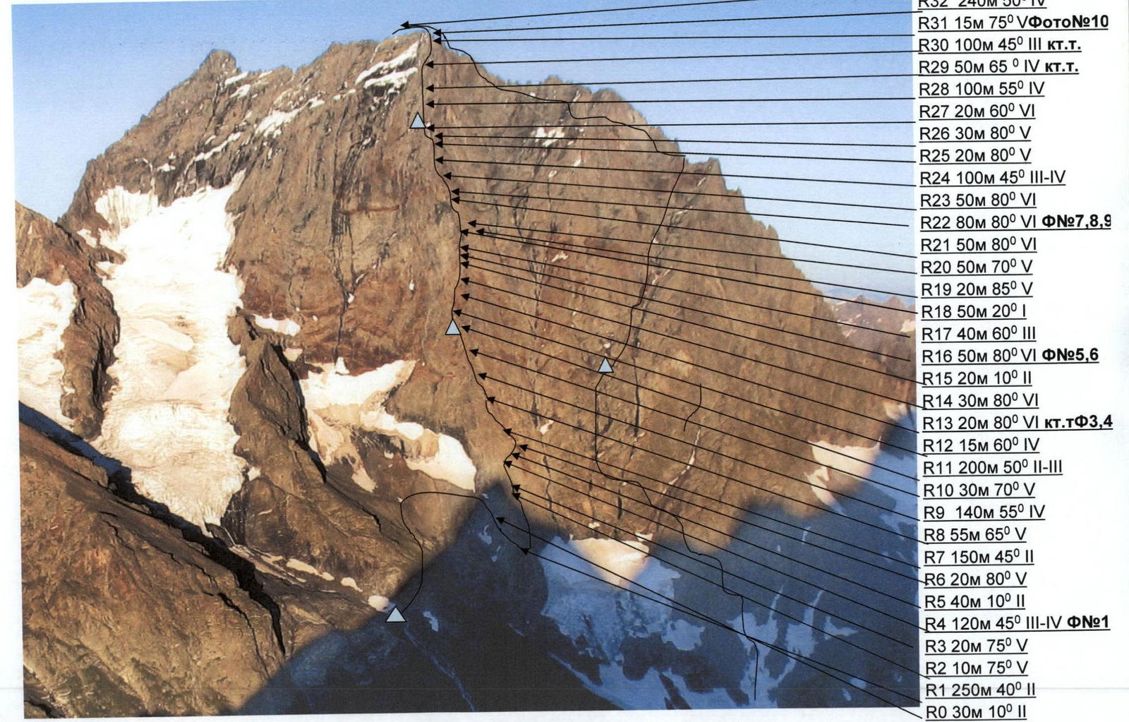
View of Dombai massif from the West. Photo from peak INEY.
Profile view of the route
Route description by sections
Departure from former AUSB "Alibek" base camp on August 5, 2007 at 14:30. Descent to Dombai settlement, registration at EMERCOM. Approach from Dombai glade via trail to Chuchkhur waterfalls and further right to Ptysh bivouacs, then up to "Baranii lby" bivouacs — 4 hours. First bivouac.
August 6, 2007. Departure from bivouac at 7:30. Approach to the start of the route via moraine in 30–40 minutes. It's necessary to fetch water as there's no water on the route.
R0 — via simple rocks along a ledge to the right towards the start of the ridge. Start of work — 8:30. R1 — via uncomplicated rocks to the right of the ridge, simultaneous movement in two teams. R2–R3 — a small wall, 5th category climbing, transitioning into an internal corner, movement via rope railings. Exit to the ridge. R4 — movement along the ridge to a gendarme. Descent 5–7 m to a saddle. Climbing of medium complexity, alternating movement. Photo 1. R5 — approach via uncomplicated rocks under a small wall. R6 — complex 5th category climbing up the wall, movement via rope railings. R7 — movement via alternating ledges and uncomplicated rock walls. R8 — steep wall, 5th category climbing, overcome via free climbing on chocks. Movement via rope railings. R9 — climbing of medium complexity, alternating movement in two teams. Insurance on chocks (friends). Periodically needed to hang rope railings on small sections. R10 — small wall, movement via rope railings, insurance on chocks. R11 — long uncomplicated slope, periodically alternating ledges and uncomplicated ridge sections. Approach under a clearly visible black niche. First place where water was found on the route. If one tries, it's possible to fetch 1.5 liters of water in 20 minutes. At this location, according to the description from EMERCOM, bivouacs are marked, but we didn't find obvious platforms. R12 — small inclined wall of medium complexity, leads to the ridge. Approach under a clearly complex wall (6). Control cairn. Photo #4. Found a note from the Mountain Club of Ukraine "Extrim" dated July 30, 2004, team leader Grafov E.V. R13 — wall, 6th category climbing, passed to the left of an overhang. Uncomfortable station on a small ledge for two. Hung rope railings. According to the description from EMERCOM, ahead are sections with 6th category complexity climbing, next possible bivouac only after 170–200 m, and no data on water availability. At 18:30, decided to descend to the start of section R12 where water was found. Found old buried platforms, canned goods from 1989. Built new platforms. Comfortable bivouac. Photo 4. View of the route from the bivouac. R0–R13 — 10 hours of climbing. August 7, 2007. Departure from bivouac at 8:30. Worked on section R13. Photo #3. R14 — complex 6th category climbing up the wall via an inclined crack. Passed via free climbing, insurance on chocks, mostly friends. Photo #2. Rocks heavily destroyed, holds crumbling. Group movement via rope railings. R15 — via uncomplicated inclined ledge to the right, approach under the next complex wall. R16 — complex 6th category climbing up the wall straight up. Most complex upper part — a 7 m vertical climbing section. Group movement via rope railings. Comfortable station. Photo #5–6. R17 — medium complexity inclined wall. Simultaneous movement. Good platform for bivouac at the top, but without water. R18 — according to the description from EMERCOM: "Movement up the wall 20 m, 4th category complexity, then to the right via an inclined ledge 20 m, 4th category complexity. Problematic exit for the last climber. Recommended for the last to exit via pendulum." Movement of the last with a backpack seemed quite problematic. Descended a bit down to a large inclined ledge, along it to the right about 50 m and approached under a steep wall. Into the middle part of this wall, a pendulum was planned. R19 — passed this wall from the bottom, hung vertical rope railings. Station not very good.
Attention for subsequent climbers! A more logical variant is possible, as in the description, but first, the whole group needs to exit higher to the start of section R20 and only then the last climber exits via a small pendulum. The exit for the last from the station in this case is safe. R20 — complex inclined internal corner, 5th category climbing. Difficult to organize intermediate insurance. Whole group movement via free climbing with alternating insurance. Upper station very uncomfortable, only for 2 people. R21 — section of complex 6th category climbing. Movement via rope railings, exit to a good inclined ledge. Comfortable station. Photo #7. R22 — complex wall, 6th category climbing, transitioning into a complex internal corner. Movement via rope railings. Exit to a gendarme "Klyuv". Photo #8–9. R23 — complex 6th category climbing. Exit to the ridge, good station for two. All sections of 6th category climbing were passed by the first via free climbing, without using ITO. Insurance — chocks. R24 — movement along a sharp ridge. Organization of alternating insurance for each team. On the ridge, a comfortable platform for a tent, but without water. Approach to the base of a gendarme. R25 — 18:00, weather deterioration. Started drizzling, turning into hail. Rocks quickly became wet and icy. Movement up the wall to the right and slightly down from the ridge. Complex climbing. Complex insurance organization. R26 — movement up a chimney via icy rocks. First worked ITO on small chocks. Exit to the top of the gendarme. For the second team's ascent, organized rope railings from the top of the gendarme. R27 — wall of medium complexity. Approach to the exit to the ridge, simultaneous movement. 30 m to the left, saw a large stream, stopped to fetch water. First water on the route. Weather improved. Hail stopped. Not knowing if there would be water further, decided to stop for the night. Made two platforms for 2 people each. Semi-sitting bivouac. R14–R27 — 9.5 hours of climbing. August 8, 2007. R28 — departure from bivouac at 8:00. Movement via rope railings along the ridge of medium complexity. After 100 m, exit to a ledge with a comfortable platform for bivouac. Control cairn. No note in the cairn, left our own, moving the cairn to a visible spot. Some remains of old ice. No water. R29 — movement from bivouac straight up, complex 5th category climbing, simultaneous movement in teams. Exit to a wide scree couloir. R30 — simultaneous movement along the scree couloir. Small walls encountered. Found a control cairn built during the winter first ascent by the Irkutsk Federation of Alpinism team, team leader Krivosheev M.L. via NW crack, winter 6A on February 16, 2005. Couloir approaches a small wall, under it a good spot for a tent. No water. R31 — movement via an internal corner. Complex 5th category climbing. Organized rope railings. Exit to the ridge. R32 — movement along the ridge. Each team moved independently. Simultaneous movement in teams. R33 — reached the summit at 13:40 on August 8, 2007. Photo on the summit #11–12 Photo #13–14. View from the summit. R28–R33 — 5.5 hours of climbing. No note found on the summit, although there are plenty of empty cans. Left our own. A bit below the summit on the ridge, two good platforms for tents. No water.
Descent from the summit Roughly follows the recommendation of EMERCOM via the ridge towards peak TsDSA and Treugolnik. From the summit, from the platforms under the tents, rappel 20 m (stationary station made of a cable is hung). Descent goes along the right side close to the ridge in the direction of peak TsDSA. Rappelings alternate with movement along inclined ledges. Slope heavily destroyed. Water available.
Before peak Treugolnik, there are good platforms for bivouac. From them, descent goes down along a visible couloir. Rappelings. Some rappelings are very serious. Photo #15–16.
At 17:00, weather started to deteriorate, sometimes fog rolled in, greatly limiting visibility. At 18:30, made a platform for a tent and stopped for the night. Water available. 4 hours of climbing from the summit.
August 9, 2007. Departure from bivouac at 9:00. Continued descent in the direction of the glacier. Planned to exit to the glacier and descend via it to the moraine. Glacier heavily broken. Decided to descend down the rock slope. Reached Ptysh bivouacs at 15:00. Photo #17. 6 hours of climbing. Return to "Alibek" base camp at 22:00.
- Climbing hours to the summit: 25 hours
- Descent from the summit, climbing hours: 10 hours
- Total climbing hours: 35 hours
 (Information about sections displayed on the scheme in img-7.jpeg):
- R33: (Photo #11, #12, #13, #14)
- R32: 240 m, 50°, 4
- R31: 15 m, 75°, 5 (Photo #10)
- R30: 100 m, 45°, 3 category
- R29: 50 m, 65°, 4 category
- R28: 100 m, 55°, 4
- R27: 20 m, 60°, 6
- R26: 30 m, 80°, 5
- R25: 20 m, 80°, 5
- R24: 100 m, 45°, 3–4
- R23: 50 m, 80°, 6
- R22: 80 m, 80°, 6 (Photo #7, #8, #9)
- R21: 50 m, 80°, 6
- R20: 50 m, 70°, 5
- R19: 20 m, 85°, 5
- R18: 50 m, 20°, 1
- R17: 40 m, 60°, 3
- R16: 50 m, 80°, 6 (Photo #5, #6)
- R15: 20 m, 10°, 2
- R14: 30 m, 80°, 6
- R13: 20 m, 80°, 6 (Photo #3, #4)
- R12: 15 m, 60°, 4
- R11: 200 m, 50°, 2–3
- R10: 30 m, 70°, 5
- R9: 140 m, 55°, 4
- R8: 55 m, 65°, 5
- R7: 150 m, 45°, 2
- R6: 20 m, 80°, 5
- R5: 40 m, 10°, 2
- R4: 120 m, 45°, 3–4 (Photo #1)
- R3: 20 m, 75°, 5
- R2: 10 m, 75°, 5
- R1: 250 m, 40°, 2
- R0: 30 m, 10°, 2
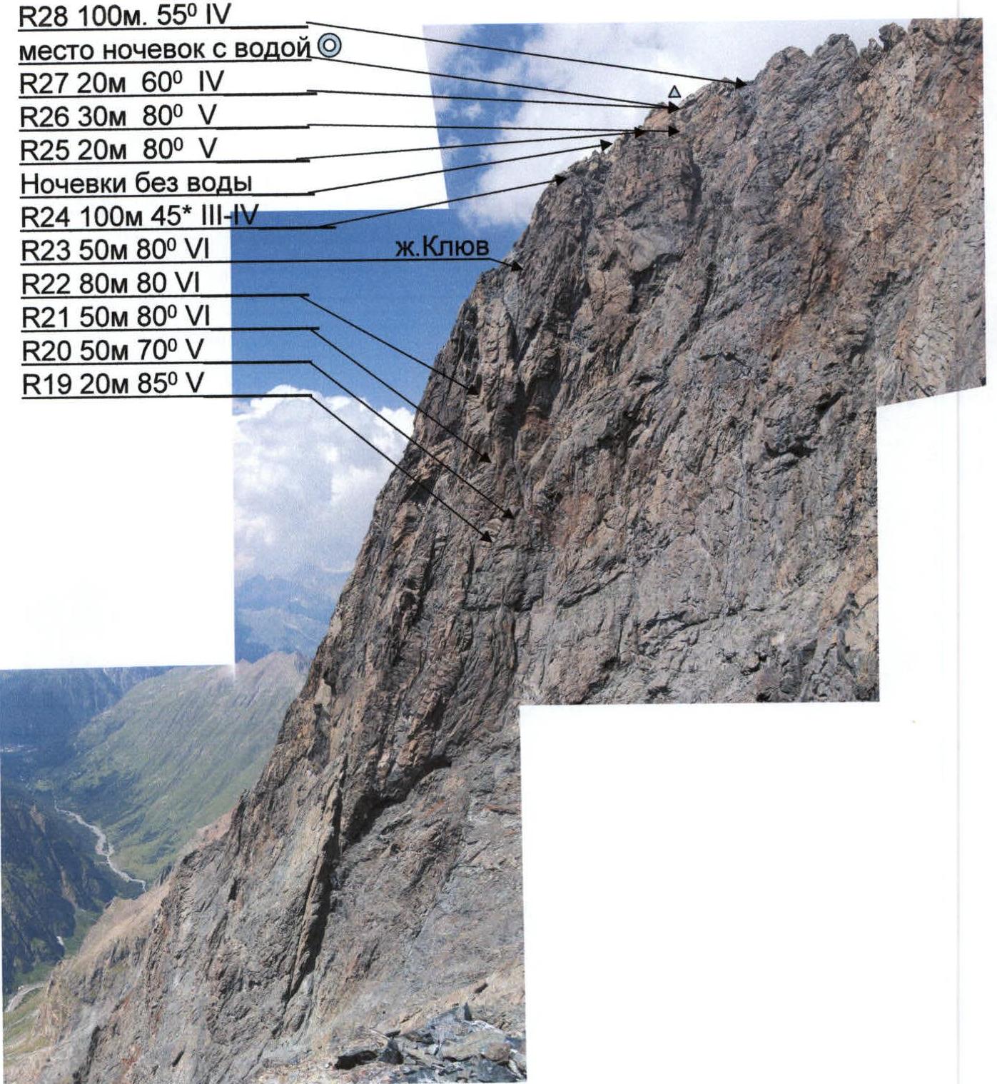
Profile of the middle part of the route. Sections R19–R28 (5–6 category complexity)
Route scheme in UIAA symbols
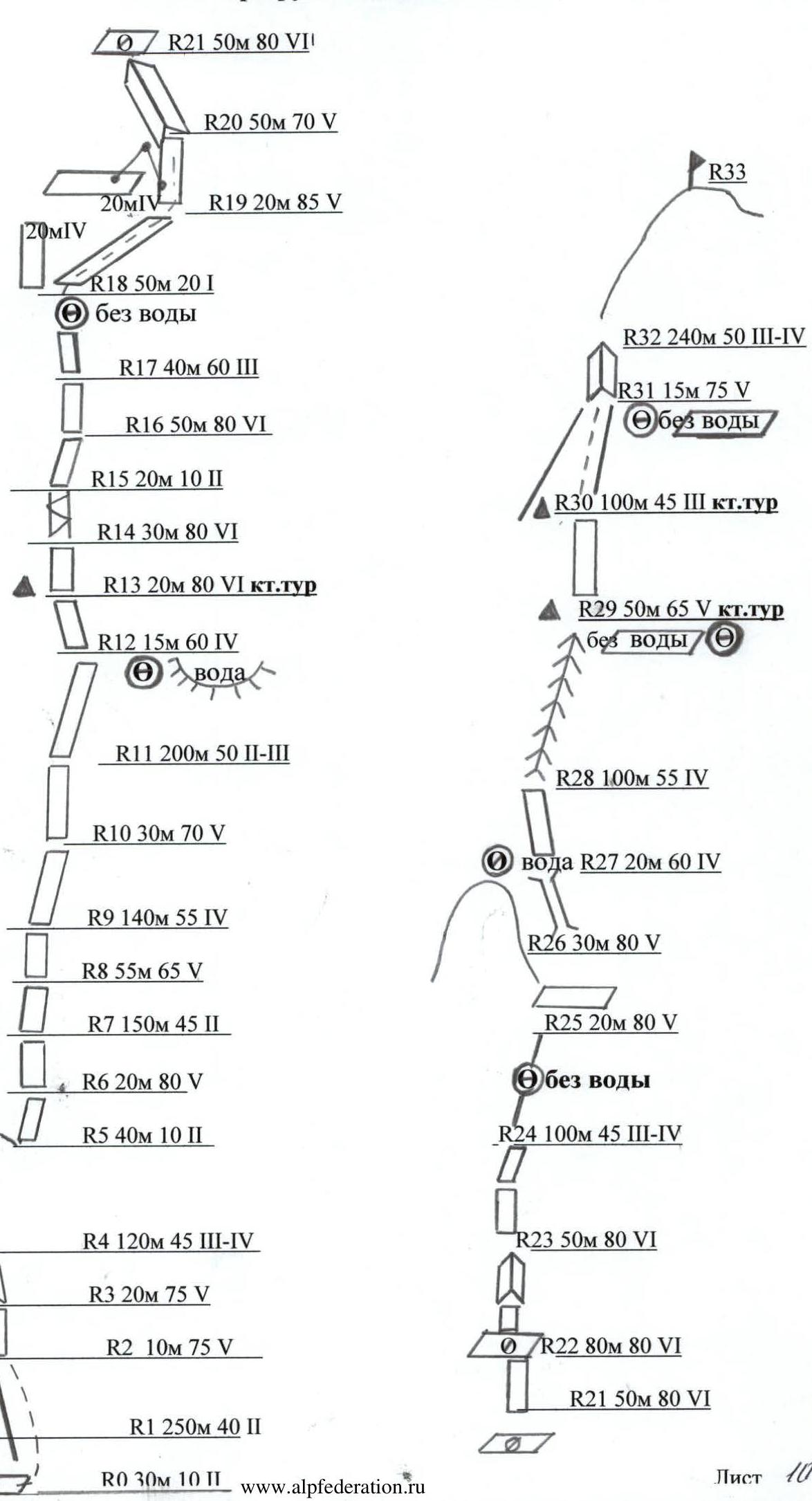
Photo #1. Section R4. First climber's work.
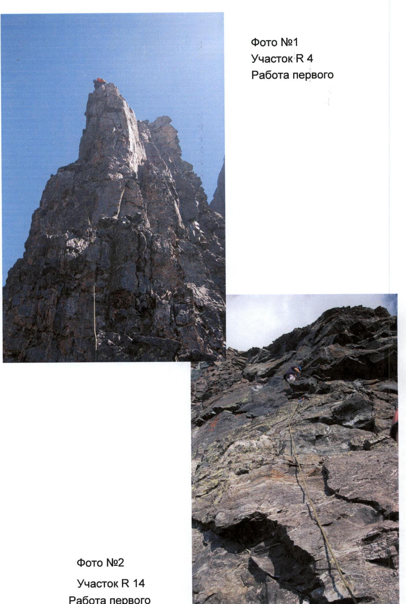 Photo #2. Section R14. First climber's work.
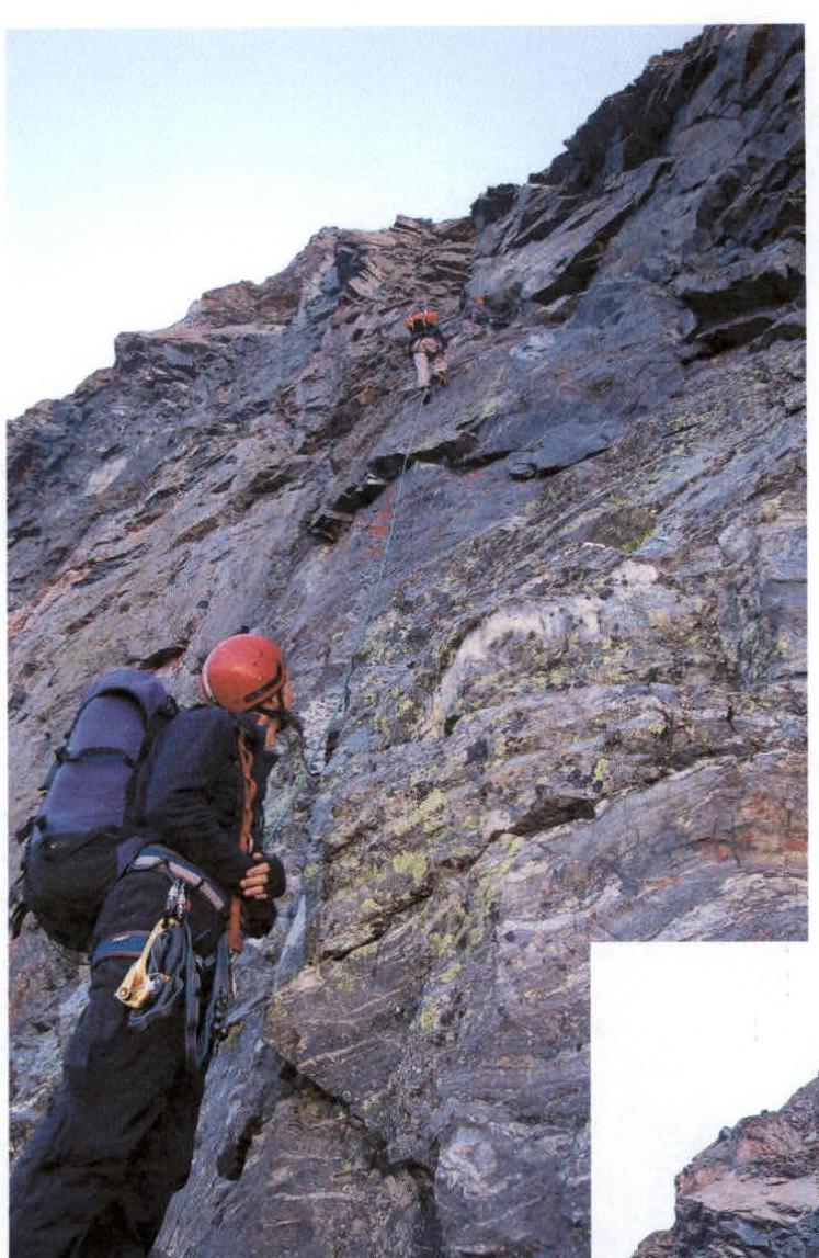
Photo #3. Section R13. Control cairn. Second climber's ascent via rope railings.
Photo #4. View from the first bivouac to section R12–R13.
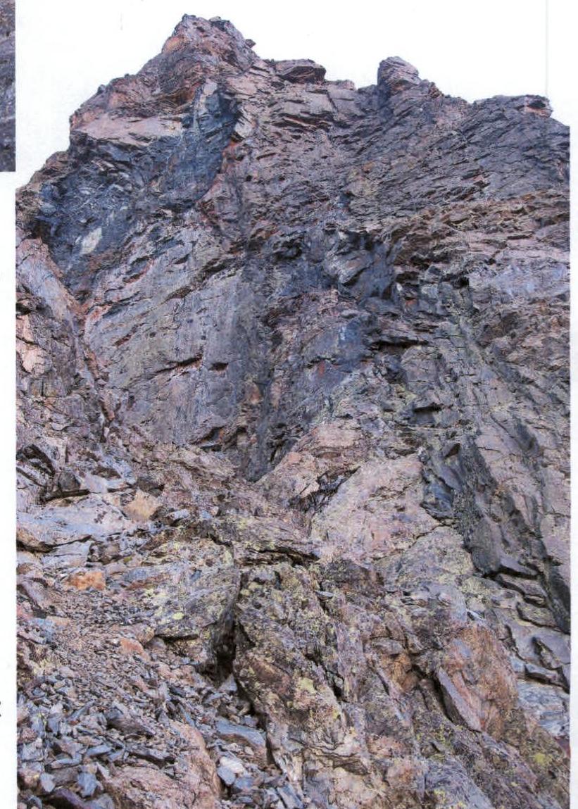
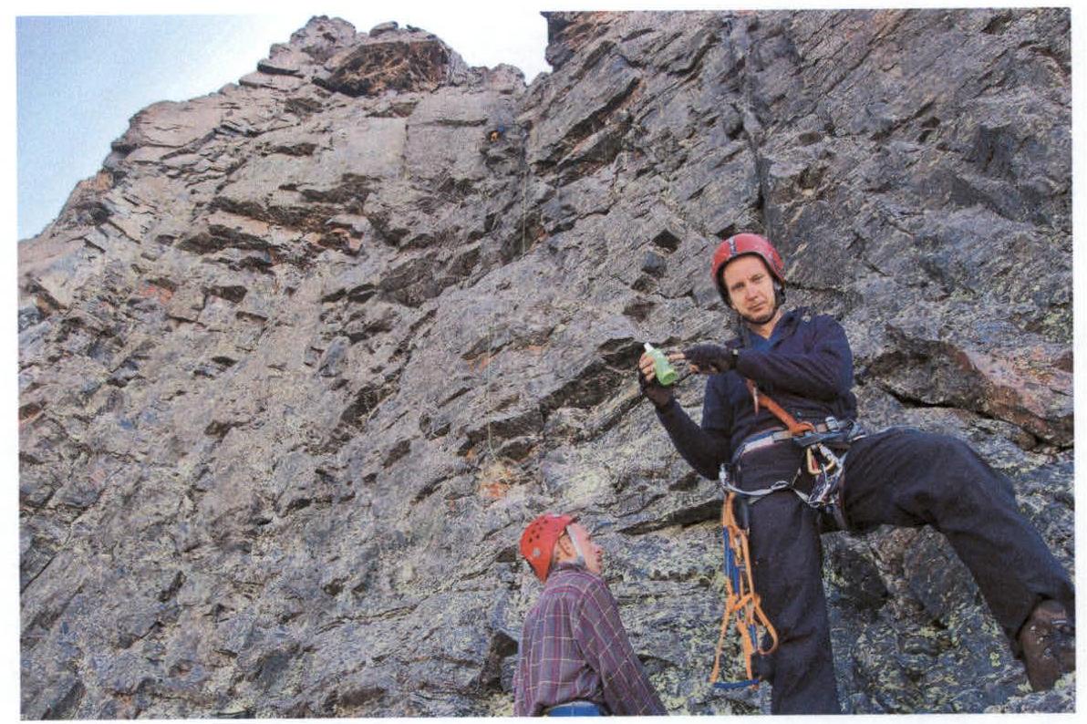
Photo #5. Section R16. First climber's work. Not even "Maskitol" helps on the route.
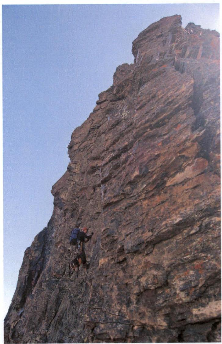 Photo #6. Second climber's ascent on section R16.

Photo #7. Section R22. Work on the station.
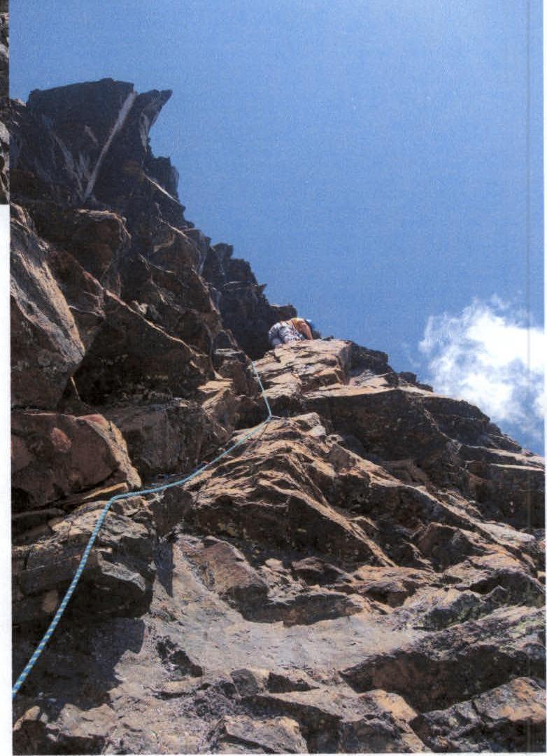 Photo #8. Section R22. Start of the first climber's work.
Photo #9. Section R22. Start of the first climber's work.
Photo #8. Section R22. Start of the first climber's work.
Photo #9. Section R22. Start of the first climber's work.
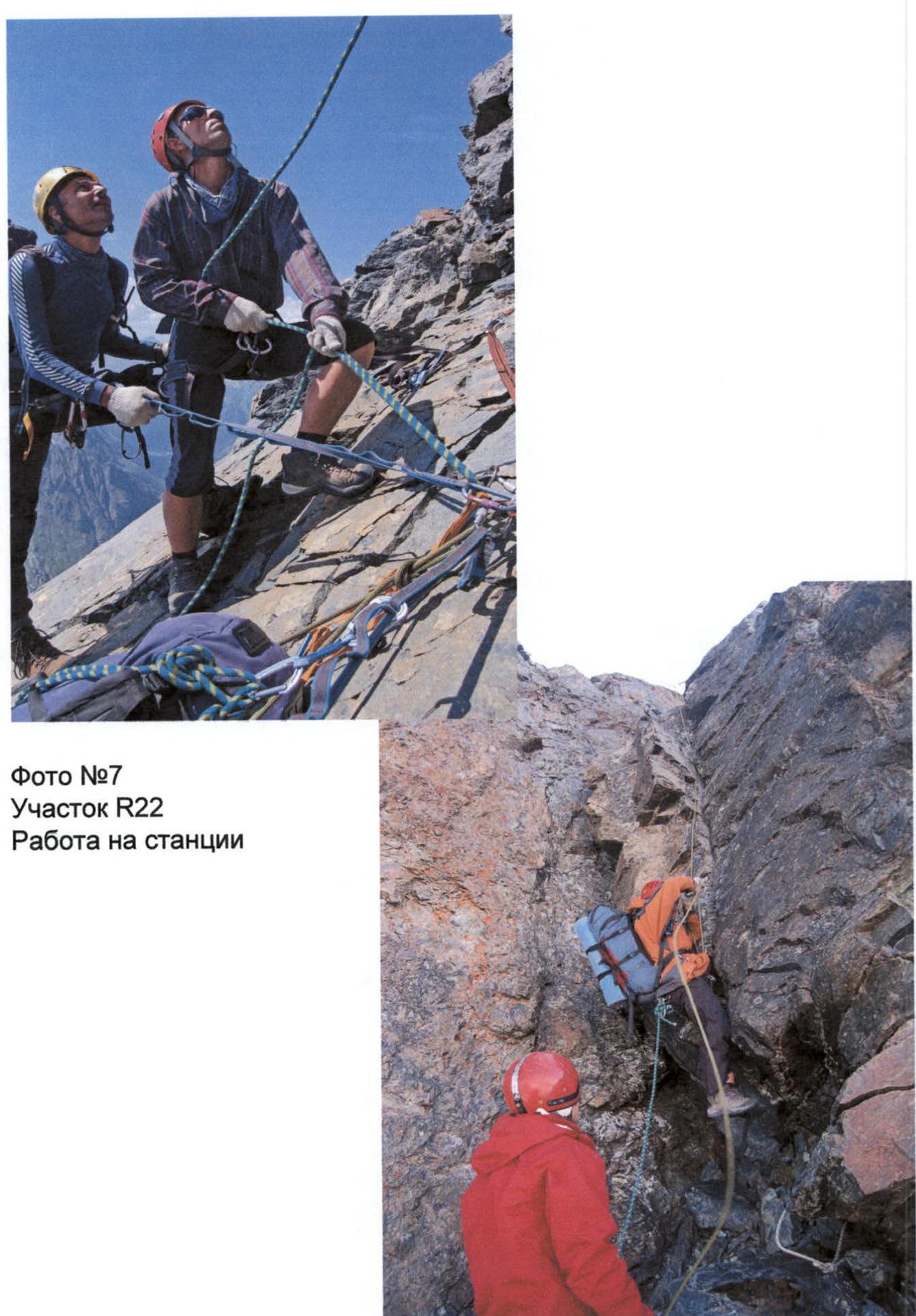
Photo #10. Section R31. Second climber's ascent via rope railings.