PASSPORT
- Rock class
- Western Caucasus from Marukh pass to Nakhar pass
- Peak Dombay (Main) via north-eastern wall
- Categorized route 5B category of difficulty
- Height difference: 787 m
Length — 1100 m. Length of sections with 5–6 category of difficulty — 345 m. Average steepness of the main part of the route — 62°, including 5 category of difficulty — 78°. 6. Pitons hammered: — 126
| rock | bolt | chockstones | ice |
|---|---|---|---|
| 62 | 0 | 64 | 0 |
| 0 | 0 | 0 | 0 |
-
Team's working hours: 24 hours and 2 days
-
Overnights: one, on a platform carved on a snow-ice slope
-
Leader: Andryushchenko Anatoly Viktorovich | Master of Sports | Deputy leader | Fursov Yuri Sergeevich | Candidate for Master of Sports | | ------------ | ------------------------ | --- | | Team members: | Chuenko Sergey Antonovich | Candidate for Master of Sports | | | Oleinikov Nikolay Petrovich | Candidate for Master of Sports | | | Nedelkin Vladimir Ilyich | Candidate for Master of Sports | | | Samorezov Vladimir Petrovich | Candidate for Master of Sports |
-
Coach: Andryushchenko Anatoly Viktorovich
-
Approach to the route — July 18, 1983 Summit — July 19, 1983 Return — July 20, 1983
Taken on June 20, 1983 at 10:00. T-43 lens, focal length 40 mm, distance 1.5 km, height 2600 m, shooting point #1.
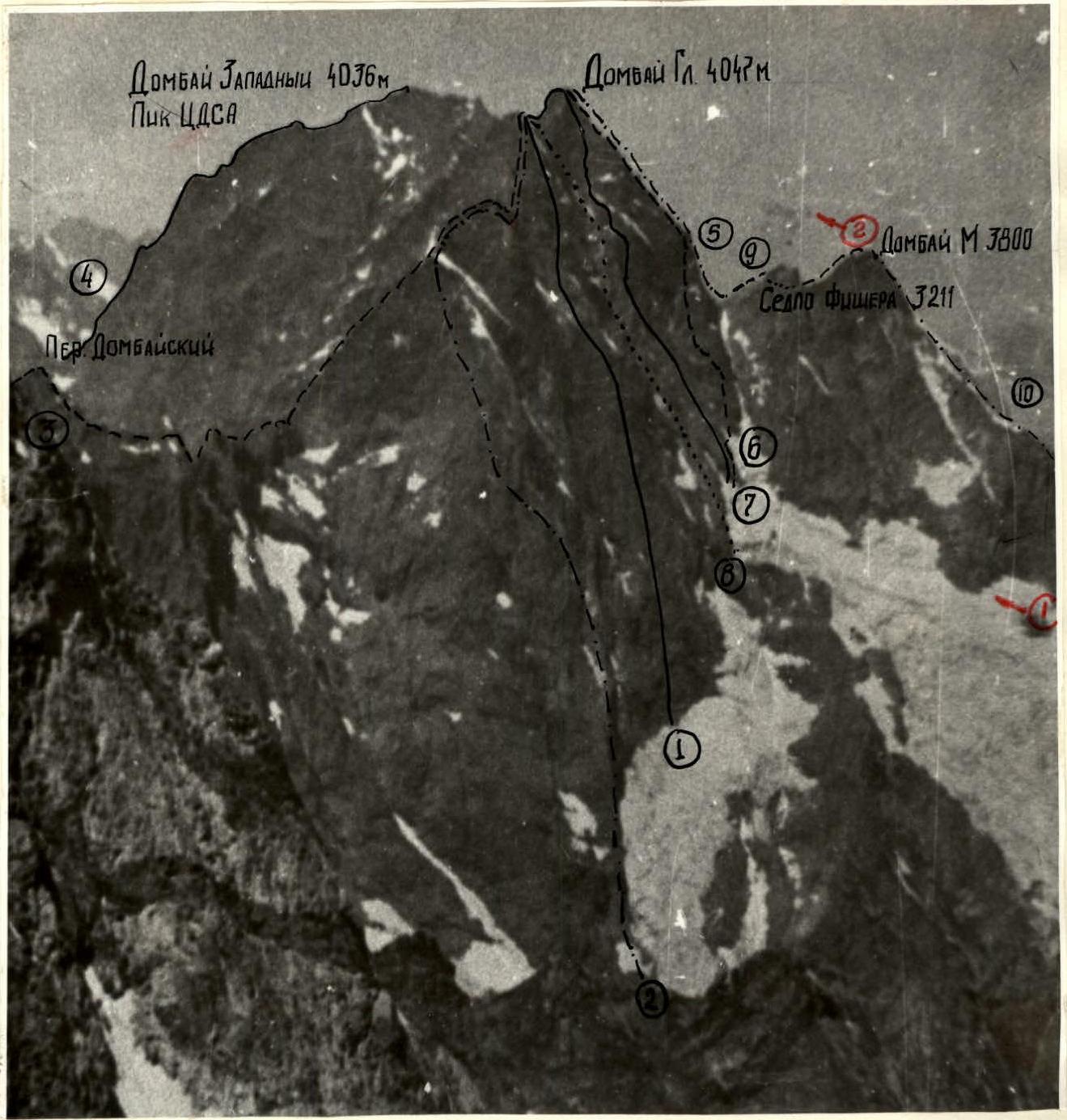
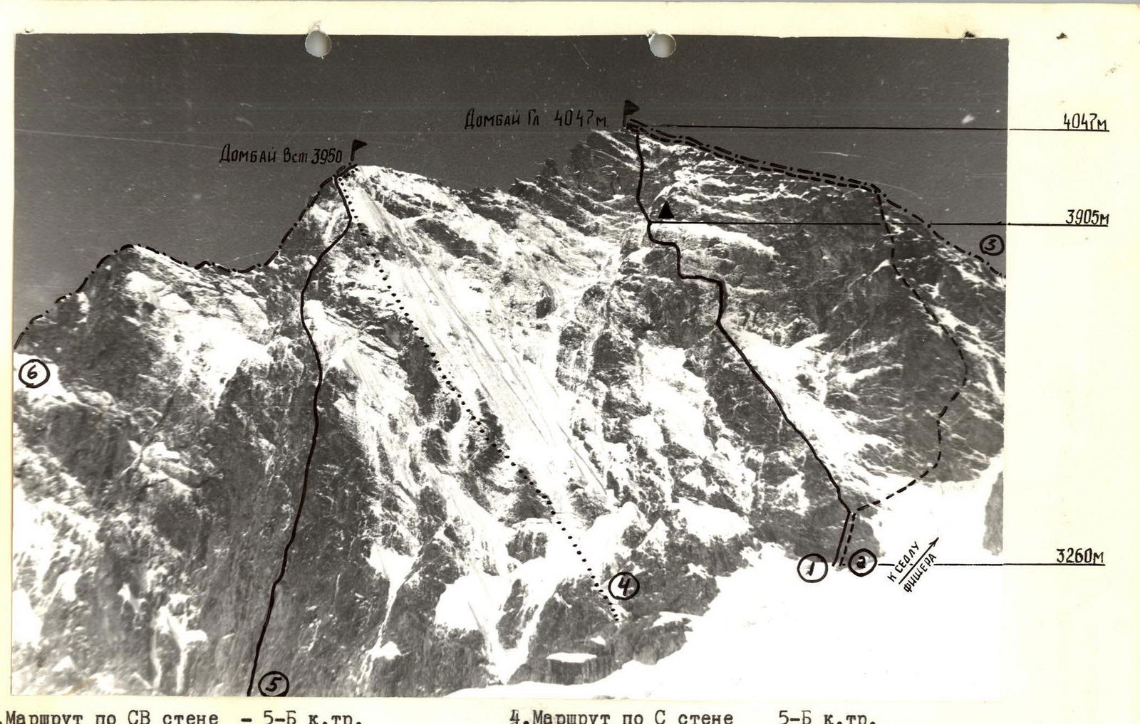
PHOTOPANORAMA OF THE AREA
-
- Gubanov's group route on peak Dombay (E) — 5B category of difficulty
-
- Sharov's group route on peak Dombay (E) — 5B category of difficulty
-
- Traverse route from Bu-Ulgen saw — 5B category of difficulty
-
- Route on peak Dombay (W) — 5A category of difficulty
-
- Route on peak Dombay (Main) — 3B category of difficulty
-
- Ovchinnikov's group route on peak Dombay (Main) — 5A category of difficulty
-
- Ovchinnikov's group route on peak Dombay (Main) — 5B category of difficulty
-
- Struk-Kosmachov's group route on peak Dombay (E) — 5B category of difficulty
-
- Route on peak Dombay (Minor) — 2B category of difficulty
-
- Route on peak Dombay (Minor) — 4A category of difficulty
Taken on August 25, 1983 at 10:30. T-43 lens, focal length 40 mm, distance to object 4 km, #3, height 3200 m.
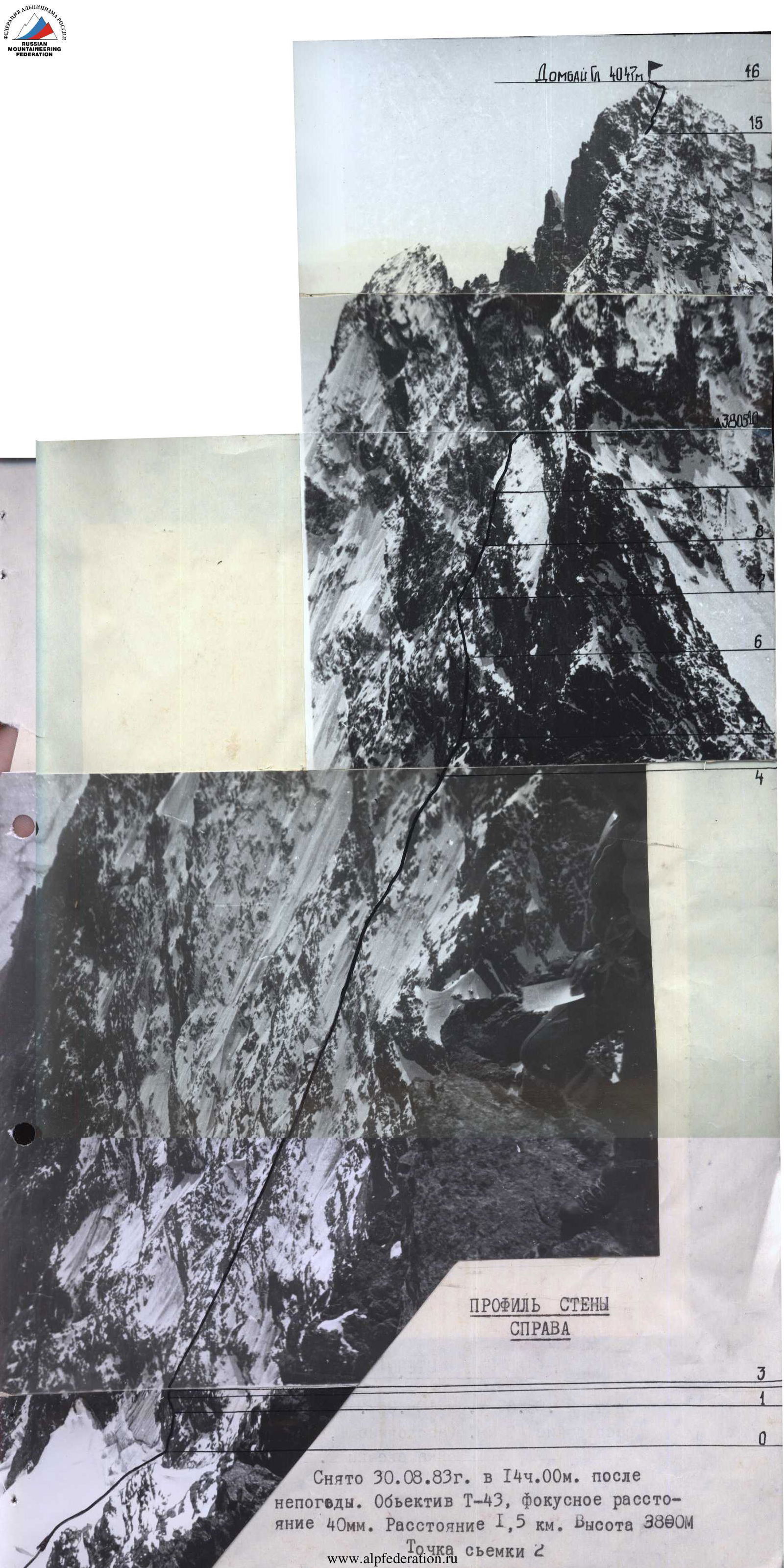
Taken on August 30, 1983 at 14:00 after bad weather. T-43 lens, focal length 40 mm. Distance 1.5 km. Height 3800 m. Shooting point 2.
WALL PROFILE FROM THE LEFT
Taken on August 20, 1983 at 10:00. T-43 lens, focal length 40 mm. Distance 1.5 km. Height 2600 m. Shooting point 1.
TACTICAL ACTIONS OF THE TEAM
The entire route was planned to be completed from July 17 to July 20, with an additional day in case of bad weather. The team completed the route within the timeframe specified in the initial tactical plan.
On July 17, 1983, an approach was made to the overnight stay on the slope of peak Dombay (Minor), and by 15:00, the team was on the glacier under the route. The route was reviewed again, and final instructions on the tactics for traversing the route were given in the evening.
On July 18, 1983, at 5:00, the pair Andryushchenko-Nedelkin set out on the route with four ropes. The rest of the team followed at 5:40. They reached the planned overnight stay on schedule. A bivouac was organized on a shelf with snow. The pair Oleinikov-Chuenko worked on further route preparation. They prepared three ropes. Soon, bad weather set in: a thunderstorm, rain with snow, and the preparation had to be stopped.
The next day, due to bad weather, they started the route at 9:00. Progress was hampered by fresh snow and icy rocks in some places. They traversed along the hung ropes, then proceeded another three ropes but did not reach the ridge due to a thunderstorm. After waiting out the storm, the group reached the ridge only at 17:00 and summited at 17:50.
The descent followed the 3B category route towards Dombay Saddle and then to the glacier. They reached the glacier at 20:30 and set up camp at 21:00.
The change of leads was carried out according to the tactical plan as follows:
- Day 1: Andryushchenko-Nedelkin — sections R0–R10
- Chuenko-Oleinikov — preparation of section R10–R11
- Day 2: Chuenko-Andryushchenko — sections R10–R18
The team had 6 ropes. Everyone moved on a double rope. The first person went on a double rope, while the rest used fixed ropes and top-rope belay. The fixed ropes were secured to 3–5 pitons, blocked together. The work was carried out clearly and efficiently. Pitons and ropes were passed on in a timely manner.
The tactical plan was fully executed. The reserve day for bad weather was not used. The route was completed with one overnight stay.
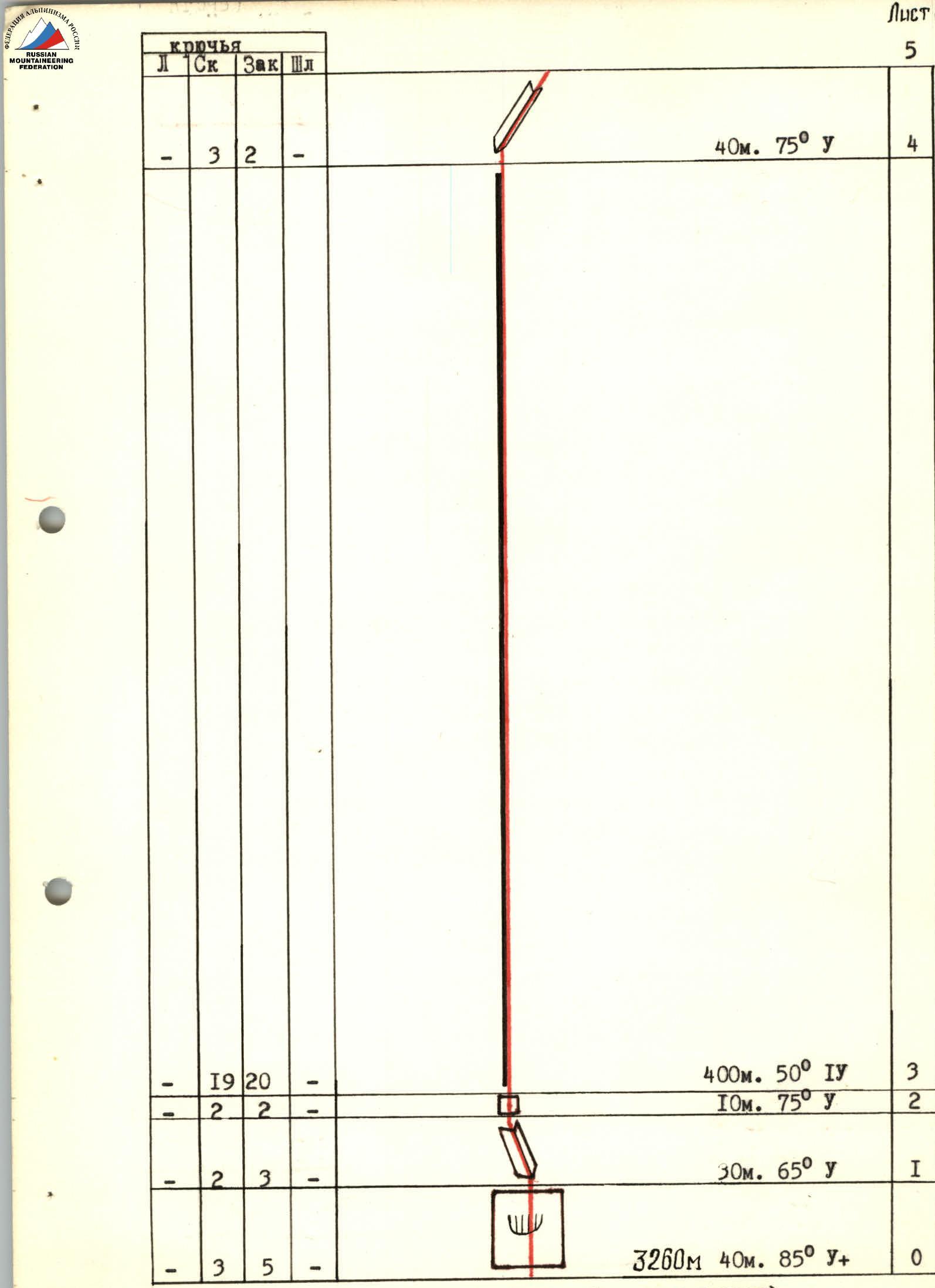
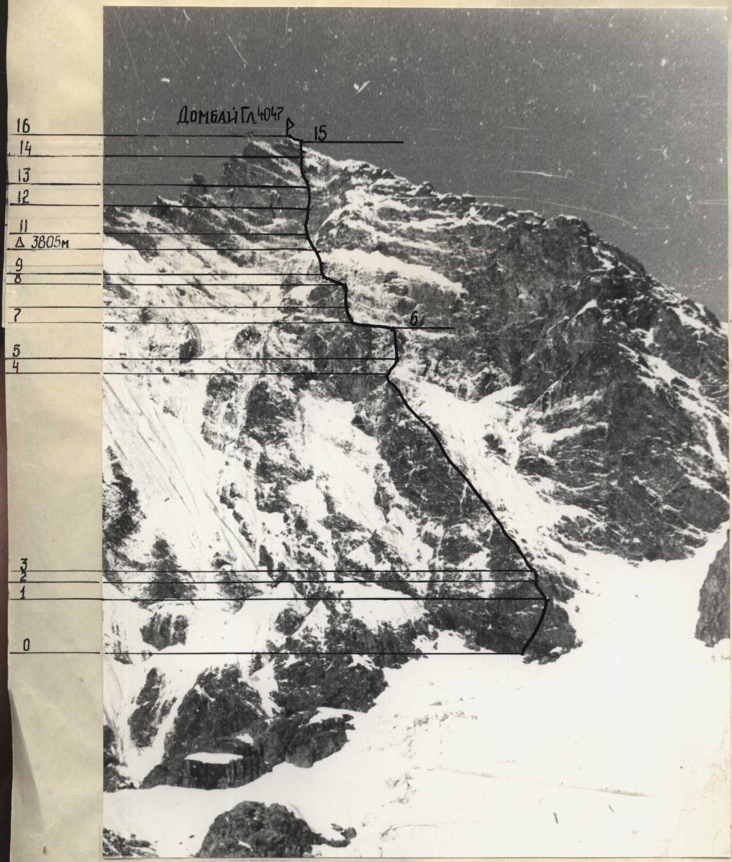
ROUTE SCHEME IN UIAA SYMBOLS
(Scale 1:2000)
| Section | Rock | Chock | Bolt | Length (m) | Steepness (°) | Category |
|---|---|---|---|---|---|---|
| Peak Dombay (Main), 4047 m. Working hours — 24 hours. Total pitons — 126 | ||||||
| R15 | 1 | 2 | - | 100 | 35 | III |
| R14 | 3 | 2 | - | 25 | 70 | y |
| R13 | 4 | 4 | - | 40 | 90 | y+ |
| R12 | 4 | 3 | - | 35 | 80 | y+ |
| R11 | 3 | 4 | - | 40 | 85 | y+ |
| Total R10–R15: Rock: 47, Chock: 49. Working hours — 15 | ||||||
| R10 | 6 | 5 | - | 80 | 45 | IV |
| R9 | - | 2 | - | 15 | 20 | III |
| R8 | 4 | 2 | - | 25 | 80 | IV |
| R7 | 2 | 1 | - | 20 | 70 | IV |
| R6 | 1 | 2 | - | 40 | 20 | III |
| R5 | 5 | 5 | - | 60 | 80 | IV |
| R4 | 3 | 2 | - | 40 | 75 | y |
| R3 | 19 | 20 | - | 400 | 50 | IV |
| R2 | 2 | 2 | - | 10 | 75 | y |
| R1 | 2 | 3 | - | 30 | 65 | y |
| R0 | 3 | 5 | - | 40 | 85 | y+ |
DESCRIPTION OF THE ROUTE BY SECTIONS
From the glacier, along slab-like monolithic rocks of a 40-meter wall, diagonally up to the right into an internal corner. Along the internal corner, diagonally up to the left until a 10-meter wall. Through the wall, exit onto a counterfort. There are sufficient places for belay organization. Movement is with the organization of fixed ropes.
Along the monolithic rocks of the counterfort (rocks are slab-like, smoothed, with a limited number of cracks) 400 m to the base of the wall. Along the internal corner diagonally up to the right for 20 m, and then through difficult and very difficult rocks 60 m to an inclined talus shelf (loose stones). Along the shelf to the left until the outer corner and along it to a wall. The 25-meter wall with a 3-meter overhang in the middle leads to an inclined talus shelf. Bivouac site.
Andryushchenko A.V. worked first. The lead was not changed. The group moved along the fixed ropes with top-rope belay.
Along the shelf with small walls, bypassing a large snow patch from the left, 80 m to a sheer wall. Along it 40 m straight up, and then along a monolithic internal corner 30 m to a sheer wall. Along it diagonally up to the left through a 2-meter overhang, then diagonally up to the right through a 3-meter overhang, 40 m, and then along simpler rocks 25 m to the ridge. Along the ridge, category 3B terrain, 100 m to the summit.
Chuenko S.A. worked first. The lead was not changed.
During the ascent, special attention was given to the organization of reliable belay and securing of fixed ropes. At belay stations, pitons and chockstones were blocked. In other places, up to six points were blocked. Considering the danger of falling stones on the wall and the presence of "live" stones, preference was given to places protected by overhangs and cornices when organizing belay stations, regardless of the distance from the previous station. Throughout the day, the order of movement of the team members did not change. Rucksack hauling was not performed.
There were no delays due to the lack of ropes or pitons. Chockstones were used very widely and skillfully, significantly reducing the time for belay organization.
GENERAL VIEW OF THE ROUTE
Taken on June 20, 1983 at 10:00. T-43 lens. Focal length 40 mm. Distance 1.5 km. Height 2600 m. Shooting point 1.
Coach and team captain


