Ascent Passport
Caucasus, from Marukh pass to Nakhar pass. German Komsomol Peak (3600 m) via the center of the Eastern wall. Proposed 5B category of difficulty, first ascent.
Route type: rock climbing.
Height difference: 560 m.
Route length: 700 m.
Length of sections with 5th category of difficulty: 240 m.
Average steepness:
- main part of the route from section R0 to section R25 (up to the top of the tower) 72°
- entire route from start to summit 60°
Pitons left on the route — 8, including bolted pitons — 0. Pitons used:
- ice screws — 0/0
- rock pitons — 41/0
- bolted pitons — 0/0
- chocks — 63 (0)
Climbing hours — 26, days — 3.
Team leader: Gubanov R.Yu. — 1st sports rank, 3rd category of difficulty.
Team member: Eliseev A.A. — 1st sports rank.
Team coach: Shipilov V.A. — Candidate Master of Sports, 1st category of difficulty.
Departure to the route: July 29, 2002.
Summit: July 31, 2002.
Return: July 31, 2002.
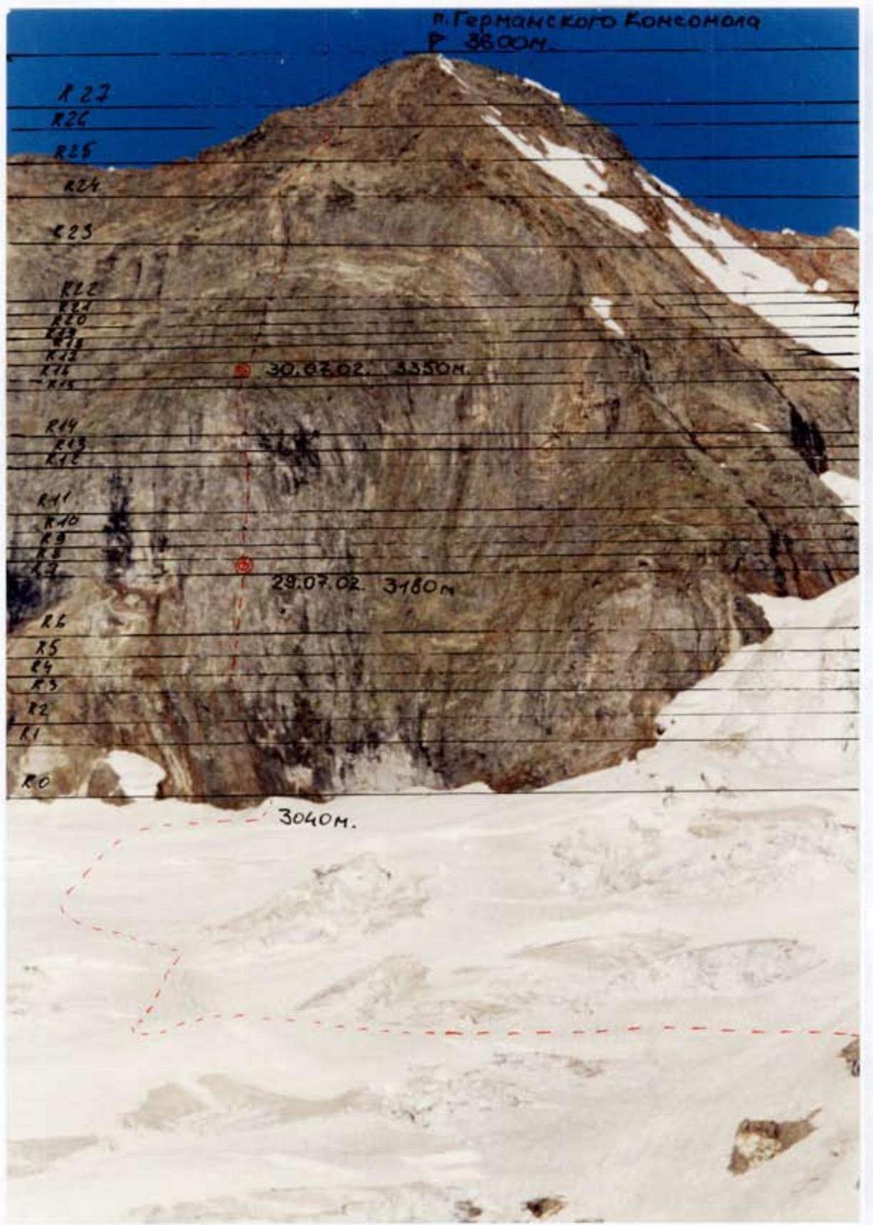
General Route Photo
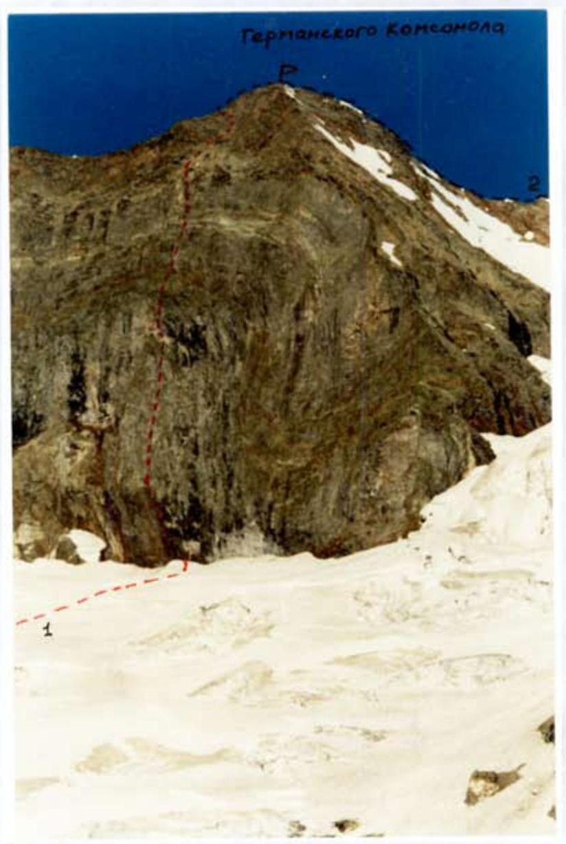
1 — route climbed by the team.
2 — route to German Komsomol Peak via NW edge from Belalakay glacier, 2A category of difficulty. (G. Starikov, 1976)
The photo was taken from the "White Rocks" bivouac (point A). July 28, 2002.
Route profile photo on the right
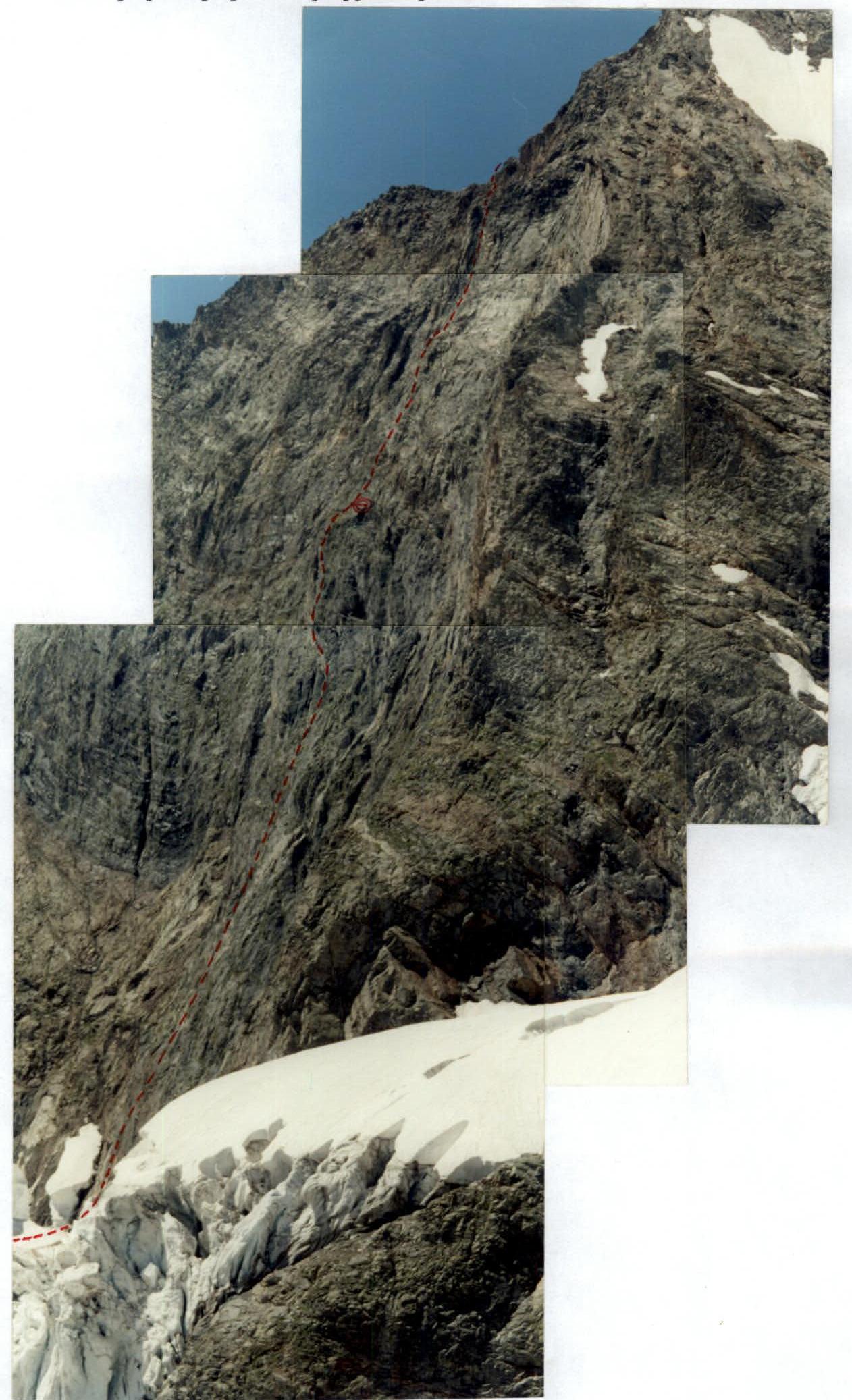
The photo was taken from the glacier to the right of the start of the route (point B) July 29, 2002.
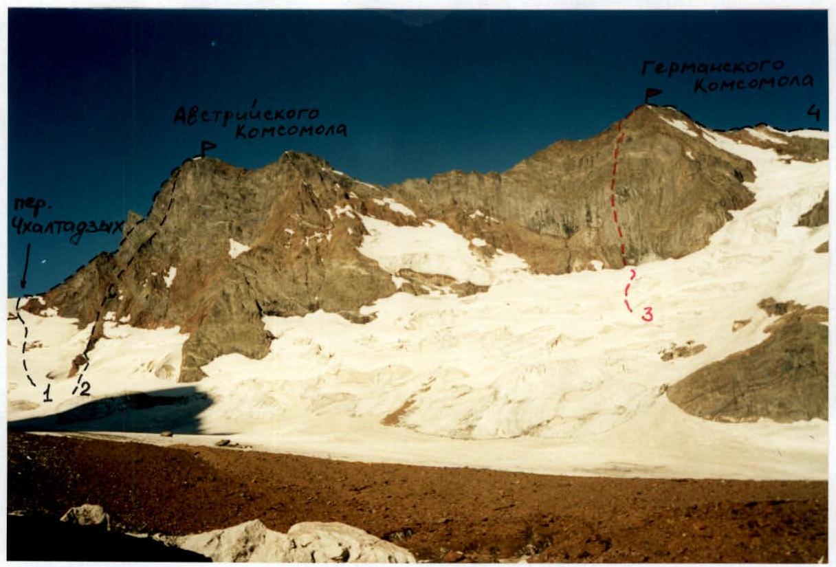
The photo was taken from the "White Rocks" bivouac (point A). July 28, 2002. The photo indicates the routes:
- 1 — Austrian Komsomol Peak via E ridge, 3B category of difficulty. (Yu. Gubanov, 1972)
- 2 — Austrian Komsomol Peak via left NE edge, 4B category of difficulty. (G. Starikov, 1976)
- 3 — route climbed by the team
- 4 — German Komsomol Peak via NW edge from Belalakay glacier (G. Starikov, 1976)
Ascent Object Map Diagram
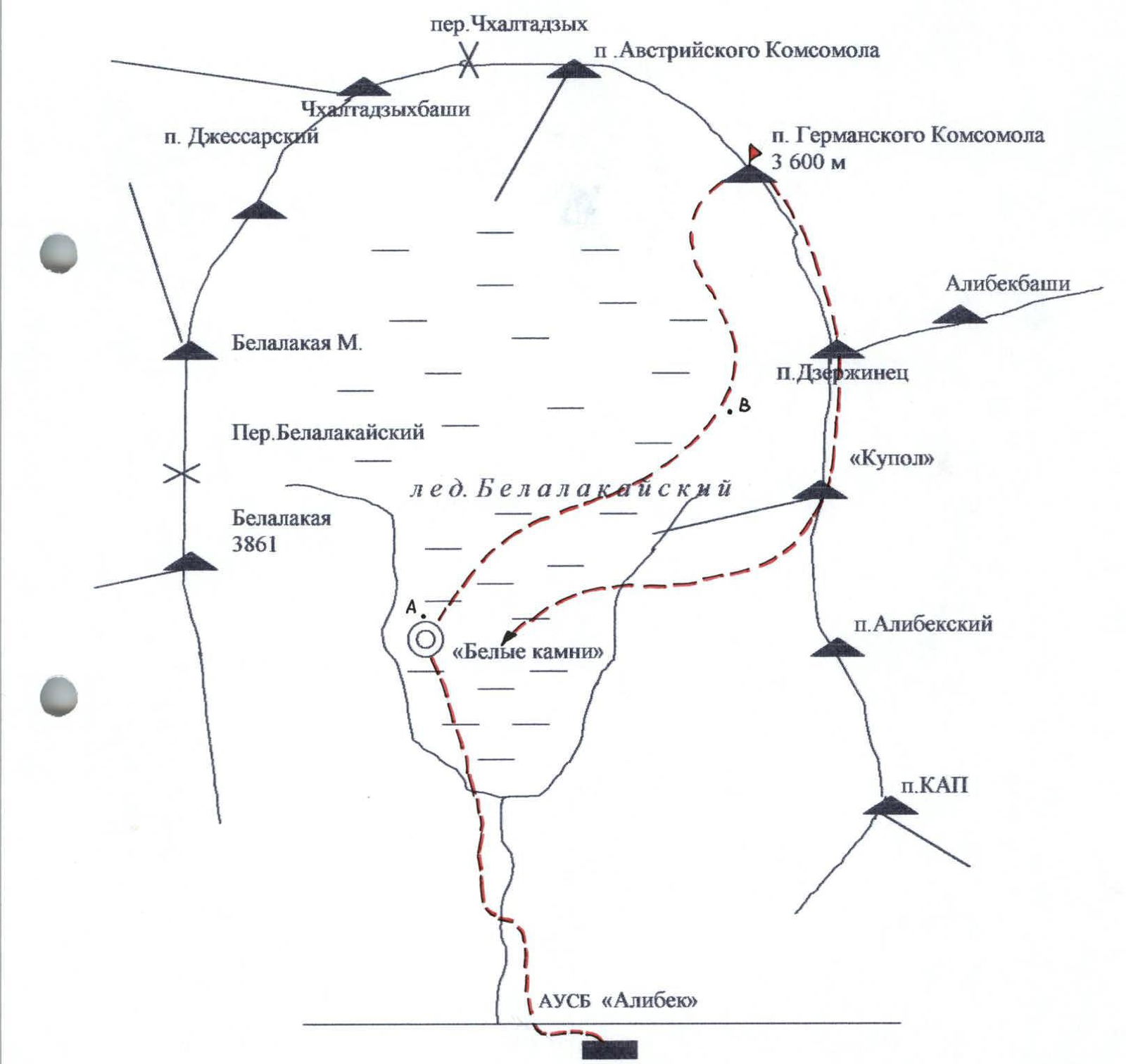
Approach to the Route Description
From "Alibek" tourist base, down Alibek valley, approximately 400 m, cross the suspension bridge to the right bank of the Alibek River. Ascend via the trail to Kapskie nochyovki (1–1.5 hours).
From the nochyovki:
- cross the river either via an avalanche (in the first half of summer),
- or via a large boulder wedged in the riverbed.
Then:
- follow the trail left onto the moraine,
- along the moraine to the lower part of Belalakay glacier (1 hour),
- up the middle part of the glacier for 30–40 minutes,
- then left under the slope of Belalakaya peak.
In the area of large "white rocks" — bivouac site. Water is available. Elevation 2545 m.
From the bivouac:
- crossing the glacier,
- ascend in the direction of the ridge extending from the snow "dome" (snowy conical peak between German Komsomol Peak and Alibeksky Peak).
From the "ram's foreheads" (left of the ridge) — move left under the eastern wall of German Komsomol Peak. 1.5–2 hours from the "White Rocks" bivouac.
The glacier crossing can be observed in advance from the ridge extending from the "dome".
Route Diagram in UIAA Symbols
| Section Number | Rock Pitons | Chocks | Friends | Difficulty | Length, m | Steepness |
|---|---|---|---|---|---|---|
| 15 | 3 | 2 | 1 | 5 | 35 | 90 |
| 14 | 4 | 3 | 5 | 10 | 90 | |
| 13 | 1 | 3 | 5 | 40 | ||
| 12 | 3 | 1 | 2 | 5 | 40 | 80 |
| 11 | 1 | 1 | 3 | 10 | 70 | |
| 10 | 2 | 1 | 5 | 10 | 80 | |
| 9 | 1 | 1 | 4 | 10 | 70 | |
| 8 | 4 | 1 | 1 | 5 | 10 | 90 |
| 7 | 4 | 2 | 6 | 5 | 40 | 80 |
| 6 | 2 | 4 | 15 | 70 | ||
| 5 | 3 | 3 | 5 | 10 | 80 | |
| 4 | 1 | 2 | 3 | 25 | 40 | |
| 3 | 1 | 2 | 25 | 60 | ||
| 2 | 1 | 2 | 5 | 25 | 70 | |
| 1 | 9 | 5 | 40 | 80 |
German Komsomol Peak (3600 m)
| Section Number | Rock Pitons | Chocks | Friends | Difficulty | Length, m | Steepness |
|---|---|---|---|---|---|---|
| 28 | 2 | 75 | 20 | |||
| 27 | 1 | 1 | 3 | 40 | 30 | |
| 26 | 2 | 2 | 40 | 40 | ||
| 25 | 2 | 1 | 2 | 50 | 40 | |
| 24 | 5 | 2 | 4 | 50 | 70 | |
| 23 | 3 | 1 | 4 | 45 | 70 | |
| 22 | 1 | 5 | 10 | 80 | ||
| 21 | 1 | 4 | 10 | 70 | ||
| 20 | 2 | 5 | 10 | 80 | ||
| 19 | 3 | 2 | 4 | 10 | 60 | |
| 18 | 1 | 3 | 20 | 50 | ||
| 17 | 3 | 20 | 50 | |||
| 16 | 2 | 1 | 2 | 4 | 10 | 80 |
Start of the Route
From the conical snowfield, left of two white patches on the wall:
- move to the counterfort extending in the lower part of the wall, in the direction from right to left;
- convenient belay location;
- cracks suitable for pitons and friends.
Then 100 m of climbing follows along the right part of the counterfort, on rock formations resembling "ram's foreheads".
1st rope
- First 10 m on a smooth, inclined slab, 4th category of difficulty.
- Then the steepness increases, the relief is practically monolithic — 40 m, 5th category of difficulty.
- Belay — friends, pitons; the belay stance is not very convenient.
2nd rope
- Next 35 m, similar relief, climbing proceeds along the boundary between the counterfort and the wall, 5th category of difficulty.
- Then a system of small ledges follows, 15 m, 3rd category of difficulty.
- Suitable for climbing and organizing a belay stance.
3rd rope
Then:
- 15 m on ledges, 3rd category of difficulty.
- followed by a challenging traverse from the counterfort to the wall, 15 m, 5th category of difficulty.
The direction of movement changes: previously, the team moved up and left, now — straight up. A good landmark — visible from the point where the counterfort meets the wall — is a light-colored wall in front of a green ledge. Then:
- 20 m along an internal corner, 4th category of difficulty, convenient belay stance.
4th rope
Upward with a slight deviation to the right, along a somewhat destroyed wall, 45 m, 5th category of difficulty, exit onto a small ledge. Good belay stance, a comfortable sitting bivouac is possible for 2–3 people. First bivouac on the route.
5th rope
From the platform, up and right, 5 m to a wall projection, then again 35 m on a not very destroyed wall, 5th category of difficulty. Not a very convenient belay stance.
6th rope
Further, in the direction of the right edge of the light-colored wall, 35 m, 5th category of difficulty, on the wall, then exit onto several inclined ledges, up and left, 15 m, 3rd category of difficulty, to the boundary between yellow and gray rocks. Convenient belay stance.
7th rope
- Straight up, 5 m,
- then 10 m slightly to the right, bypassing an overhang,
- then 15 m, deviating left, bypassing an overhang,
- 10 m straight up into an internal corner,
- 5 m along the internal corner to a small wall.
The entire rope length features solid monolithic relief with a limited number of holds. The difficulty of this section is 5th category of difficulty; this rope can be considered the crux of the route.
8th rope
Up the wall, 10 m, 4th category of difficulty, exit onto a green ledge. Second bivouac: a platform is constructed from stones for a tent, a control cairn is built nearby.
The next notable landmark is:
- a yellow tower protruding from the wall.
The direction of movement is towards the start of the tower, to its right part. From the platform, 20 m, 3rd category of difficulty, upward on simple rocks under an overhang. Good belay stance, many large cracks for chocks and friends.
9th rope
Bypassing the overhang, up and left on destroyed rocks, 10 m, then on polished rocks, 15 m upward; on this section, only pitons can be used for intermediate belay points. Further, along diagonal cracks under overhanging feather-like rocks, up and right, 15 m to the base of an internal corner. Convenient belay stance.
Section difficulty: 4–5 category of difficulty.
10th rope
Along the internal corner upward to an overhang, 15 m, then right onto a wall with several small horizontal ledges, on it, 25 m upward — to the base of a large internal corner formed where the right part of the tower meets the wall.
Convenient ledge for a belay stance, but only thin pitons can be used for belay points.
11th rope
Upward, 45 m, 4th category of difficulty, along the internal corner with an exit onto a col between the tower and the wall. Although the section is vertical, the relief allows for various climbing options:
- with an exit onto the tower crest,
- with an exit onto the wall.
The rocks are solid, with good friction. On top of the tower, a platform allows for a tent; higher and to the left — a large snowfield.
12th and 13th ropes
Along a large couloir left of the tower, past the snowfield, 100 m in the direction of the summit on simple destroyed rocks, 2nd category of difficulty.
14th rope
- Left along a ledge, 35 m, 3rd category of difficulty, exit onto a ridge.
- Then simultaneously along the ridge, 80 m, 1st category of difficulty, to the summit.
Additions
The route to the top of the yellow tower passes along the protruding part of the wall; the relief is sufficiently solid, so the probability of rockfall on the route is minimal even in bad weather. We confirmed this from our own experience — all three days of the ascent, from 15:00–16:00 to 19:00–20:00, the weather deteriorated, with rain and hail.
We reached the summit at 14:00 on the third day; there were two bivouacs on the route:
- one sitting bivouac
- one normal bivouac on a platform arranged on a green ledge
On all sections, the next landmark is clearly visible:
- first, the light-colored wall under the green ledge
- then the yellow tower
- then the summit
The route is logical and beautiful; it can be climbed in two days with a bivouac on the green ledge.
Technical photo of the route
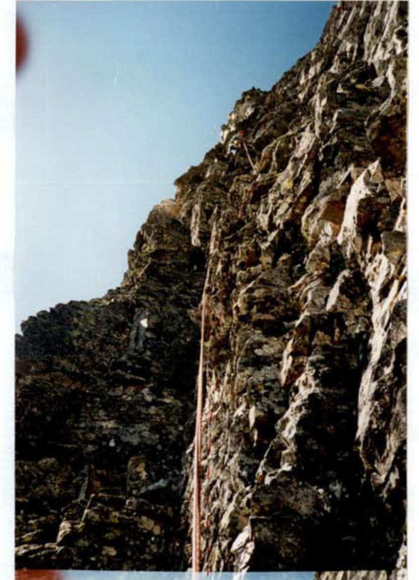
Section 24. Exit to the tower
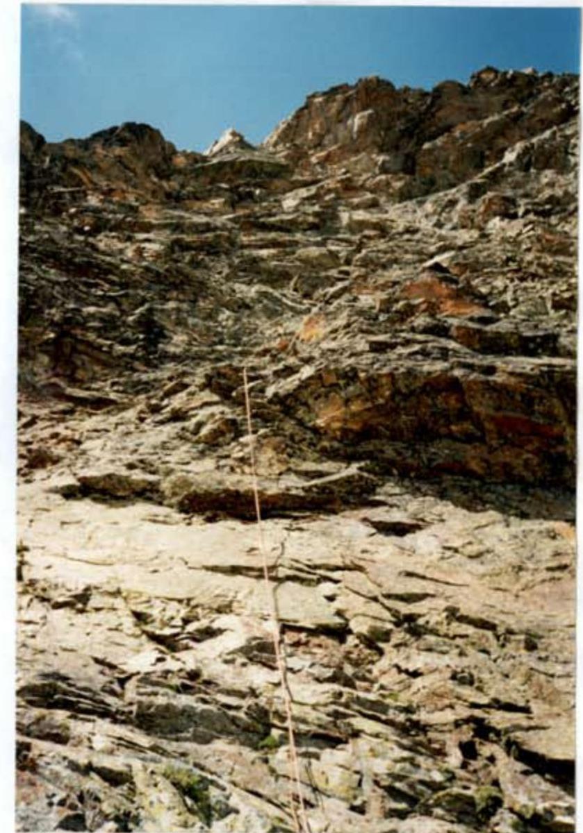
Section 24