Main peak of Amanauz via SW wall 3757 m
First ascent (approximately category 5B)
Group members:
- Kuzmuk V.V. - team leader, 1st sports category
- Shakin S.A. - participant, Master of Sports
- Bychek A.M. - participant, Candidate for Master of Sports
- Verba A.A. - participant, Candidate for Master of Sports
- Mudrenok V.N. - participant, 1st sports category
The route was climbed by the team from the "Dombay" alpine camp. Coach - Magomedov Kh.K.
Western Caucasus 1975
1. Geographical description and sporting characteristics of the ascent object
The Main Amanauz peak (3757 m) is located in a spur of the Main Caucasian Range and is one of the most interesting peaks in the Dombay region. The presence of an asphalt road and two well-known alpine camps "Alibek" and "Dombay" has led to the fact that almost all interesting routes in this area have been climbed and classified by now. The routes on Dombay-Ulgen are the most frequently visited. The highest point of the Western Caucasus has often attracted attention. The peaks of the Amanauz massif are 300 m lower, but they are cut off by walls to the east, south, and west, with a height and complexity not inferior to the walls of Dombay-Ulgen. For a long time, the peaks of Amanauz were conquered via the simplest paths:
- from Amanauzsky pass - category 3B
- from the east - category 4A
- via the northern wall - category 4B
In 1956, a group led by Romanov B. climbed a challenging route to the Main peak via the southern wall - category 5B. Over the years, only seven groups have repeated this route. Although it was the simplest path, it still hasn't lost its appeal.
In 1961, the Dвузубка peak of Amanauz was also conquered via a relatively simple route (category 5B). In recent years, routes have been laid on the Main peak:
- via the northern counterfort - category 4B
- in 1973, via the western counterfort - category 5B
Thus, by 1975, the southwest wall had been climbed from the right (via the southern wall) and from the left (via the western counterfort). Climbing the southwest wall via the center adds some completeness to the sporting characteristics of the Main Amanauz peak. But this is not the only reason for the interest in this route - the route is interesting in itself:
- the steep, in some places overhanging lower part of the wall (360 m) requires good technical preparation from the climbers
- it then turns into a kind of hyperbola cut into the wall. The base of the hyperbola, not very steep, turns into a sheer wall (200 m)
- the upper part of the wall becomes slightly gentler and again turns into a sheer third bastion, which ends with a steep pre-summit ridge
Thus, from a sporting point of view, the path from the southwest to the Main Amanauz peak is of undoubted interest.
2. Climbing conditions in the Amanauz area
a) Relief
A characteristic feature of the Amanauz massif is the diversity of its slopes in terms of steepness and structure. Part of the massif from the Main peak to the Western peak is characterized by steep walls (average steepness 80°), breaking off to the east and southwest. The part from the Western peak to the Eastern peak is not so steep. The relief here is more broken.
The southern cirque of the Amanauz glacier is bounded by a huge horseshoe of sheer walls from Sofruju to the Eastern peak. Even the exit to the Amanauz pass from the south requires the use of complex climbing techniques. The eastern and northern slopes gradually alternate with walls and counterforts.
b) Weather
The weather in Dombay is characterized by instability and sudden changes. On a serious wall ascent lasting several days, one must be prepared for the weather to deteriorate and the route to become more complicated.
The beginning and middle of July were characterized by unstable weather, worsening after 14:00. The southwest wall was always shrouded in clouds, periodically spewing streams of rain and snow. The route passes through the center of the wall and is lit by the sun from 12–13 hours.
Temperature:
- daytime: 12–18°C above zero
- nighttime: -3–5°C
The wind from the south is strong.
c) Remoteness from settlements
The southwest wall is located in the southern cirque of the Amanauz glacier. The difficulty is the passage through the northern cirque of the Amanauz glacier, which is largely broken by the middle of summer, and the descent from the Amanauz pass. From the Dombay glade - 7–8 hours. It is convenient to set up a base camp on a large moraine under the southern walls of the Amanauz pass.
3. Preliminary preparation and reconnaissance
All team members, except coach Master of Sports Shakin S.A., are members of the combined team of the Kiev regional council of the "Burevestnik" sports society. Throughout the year, the team prepared for the season, training on the rocks of the Zhytomyr region.
Participants who took part in winter climbing competitions (Kustovsky Memorial - 1975):
- Verba A.A.
- Bychek A.M.
- Kuzmuk V.V.
Verba A.A. and Bychek A.M., being candidates for Master of Sports in rock climbing, successfully performed at the Ukrainian SSR championship. The team in Dombay successfully conducted training and made a training ascent to Mt. Ertzog (category 3A). On July 7, the group led by Kuzmuk V.V. went on a traverse of all the peaks of the Amanauz massif with a descent into the southern cirque of the Amanauz glacier. Having examined the nature of the wall and finally planned the ascent route, the group returned to the "Dombay" alpine camp.
4. Organizational and tactical plan
The group's departure was scheduled for 7:00 on July 14, 1975. Due to the fact that the Amanauz glacier became impassable, it was decided to ascend to the Amanauz pass via Mt. Sofruju. The route was planned to be completed in 5 days, including preliminary processing of the wall. To communicate with the "Dombay" alpine camp, it was planned to have an observation group under the wall and a group of relay transmitters on the Amanauz pass. The departure of the auxiliary groups was scheduled for July 15 at 7:00. The backup option was to climb the classified route via the southern wall (category 5B).
The ascent was planned to be carried out as follows:
- 1st day - approach to the route
- 2nd day - processing the wall (250–300 m)
- 3rd day - start of the route and passage of the first bastion of the wall (360 m)
- 4th day - passage of the second and third bastions of the wall and exit to the pre-summit counterfort
- 5th day - ascent to the summit and descent to the camp
The tactical plan for moving along the route provided for the first participant to move without a backpack and in galoshes. To process the wall and hang ropes on the route, the following were taken:
- 4 ends of rope (main) 60 m each
- 1 end 80 m
The group was provided with food at the rate of 750 g of food per person per day. An excellent set of food and quality equipment (ropes, tents, down equipment) was partially provided by the "Dombay" alpine camp and partially brought from Kiev.
Non-standard equipment taken on the route by the group:
- Titanium carabiners - 40 pcs.
- Combined and petal rock pitons - 42 pcs.
- Titanium rock wedges - 8 pcs.
- Bolt pitons - 30 pcs.
- Bolts - 3 pcs.
- Two-step ladders - 3 pcs.
- Hammocks - 5 pcs.
- One-step ladders - 4 pcs.
- Jumar clamps - 8 pcs.
- Galoshes - 5 pairs
- Abalakov's brake - 1 pc.
All samples of non-standard equipment have four years of successful use by the group members. All types of this equipment have been tested for strength.
5. Auxiliary groups and their tasks
The observation group consisting of:
- Safiulin I.L. - leader
- Piskareva S.A. - participant
was located during the ascent of the main group on the moraine under the Amanauz pass in the southern cirque. The group conducted visual observations and carried out radio communication with the main group and the group of observers led by Zlenko N.M.
6. Route passage
First day - July 14, 1975. At 7:00, the group departed from the "Dombay" alpine camp in the composition: Kuzmuk, Verba, Shakin, Bychek, and Mudrenok. At 14:00, the group reached the summit of Sofruju and at 14:30 descended to the Amanauz pass. At 17:00, the entire team gathered on the moraine under the Amanauz pass. The descent took place in bad weather. The rocks were shrouded in fog, and a light rain was falling.
Second day - July 15, 1975. At 6:00, the group in full strength went to process the wall and at 7:00 approached the start of the route. The route begins in the upper part of the glacier. The first to climb the wall is the связка Bychek - Kuzmuk. The weather is good in the morning. The first rope (R1) is climbed with complex climbing. The first meters already make Bychek demonstrate the highest technique of moving on rocks.
The route goes:
- to the left of the overhanging part,
- then up to the right to the internal corner,
- then along the internal corner to the smooth wall.
The wall is climbed from the left, upwards using ladders. Further, complex climbing follows along sheer sections to a steep wall without footholds. This is where the first 60 m end.
Hanging on a ladder, Bychek takes Kuzmuk. Further, the path goes under the overhanging part of the wall, and from it - traversing to the right. Then straight up and along a complex wall - exit to a huge chip. Climbing is very difficult. Further, the route goes to the chip. Here the first связка finished working.
After 12:00, the связка Verba - Mudrenok should work. They began to pass R3 further. From the chip, the route goes:
- to the left,
- up along the sheer mirror of the wall (30 m).
The wall is climbed with the use of artificial support points. This is one of the most complex sections of the route. The rope gradually moves forward. The weather is deteriorating. The upper part of the wall is already in the fog. The wind is driving new clouds from the south. The other participants from the glacier correct further progress. The wall ends with a small ledge with a large chip from the wall. Here Verba takes Mudrenok. Then the route goes to the left, up along simple but steep rocks (30 m, R4), which end with an internal corner (20 m). The internal corner leads to a small ledge, from which the 2nd internal corner (R5) goes up, to the right. The internal corner ends with an overhang, which is bypassed on the right (5 m). The weather finally deteriorates, and the связка descends in thick fog. Wet snow is falling. Thus, only 240 m were passed in a whole day. At 16:30, the связка descends to the glacier and heads to the tents.
Third day - July 16. The weather is normal in the morning. At 7:00, the group approached the wall and began to pass the sections along the hung ropes. Three people organized the lifting of backpacks, and two removed the ropes. At 12:00, the связка Kuzmuk - Mudrenok begins processing R6.
After the overhanging section, the steepness of the sections decreases somewhat (about 80°) (R6). Climbing is still difficult. Ladders are often used. Bolt pitons are almost not hammered, there are cracks, although small. Mainly small petal pitons are used.
The movement was carried out as follows:
- The first participant processes the route on a double rope.
- The second lets him out with a lightened backpack.
- The rest organize the pulling of backpacks and the issuance of free rope forward.
20 m above the overhang is a narrow long shelf. From the shelf, to the left, up goes an internal corner, which is passed first on the left, and then on the right (20 m). The internal corner turns into a short but steep wall. After the wall, the route becomes more gentle and along rocks of medium difficulty and along the internal corner exits to the base of a huge hyperbolic rock funnel.
Interestingly:
- The base of the funnel collects all falling stones.
- Stones do not linger and fall down.
- Falling from a height of 320–330 m, they do not touch the wall, but fall directly onto the glacier.
Since the southwest wall is very monolithic and few stones fall, the first 350 m are not prone to rockfall. The base of the funnel is gentle (R7), and 20 m of rope are passed quite simply.
Then the path goes to the left, up along the smoothed "ram's foreheads" with few cracks (30 m) to the base of the second bastion of the wall.
The second bastion is passed:
- in the right part - along a not clearly expressed counterfort,
- then along complex rocks - to the left, up (R8).
Difficult climbing is compounded by bad weather. The fog has dropped again. Having passed another 20 m, the связка fixes the belay and begins to descend to the base of the funnel, where a bivouac was set up. Bychek, Verba, and Shakin climbed to the base of the funnel and pulled up the backpacks by this time. 300 m were passed along the hung ropes, and 210 m of ropes were hung on the third day.
It was decided to organize an overnight stay in hammocks under the overhanging part of the left side of the second bastion. A more or less flat shelf for setting up a tent was not found. Having covered themselves with polyethylene sheets from above, everyone soon fell asleep. At night, the wind dispersed the clouds, and the weather was good in the morning.
Fourth day - July 17. On this day, it was planned to drop down 2 ends of the main rope (60 m each), a reepschnur - 100 m, and everything unnecessary, and to continue on a Czech eighty-meter rope and two sixty-meter ropes. All participants were to go with backpacks, and the first - with a lightened one.
At 7:00, the group started on the route. Having quickly passed several meters, they began to process R9 further. This section is also one of the more complex parts of the route. It is passed with the use of ladders. The wall gradually becomes slightly more gentle (R10) and exits onto inclined slabs (R11). The inclined slabs gradually (R12) turn into a wall of the third bastion.
The third bastion is passed on the left side:
- straight up the wall,
- then traversing 4 m to the right,
- then again to the left, up (R13–R15).
Climbing is difficult. The third bastion gradually becomes more gentle (R16) and turns into a pre-summit counterfort. The counterfort is passed on the left side (R16). Then it becomes slightly more gentle and begins to alternate with sheer walls of about 10–15 m (R17–R18).
Again we are climbing in the fog, the summit should be somewhere nearby. The relief has become more broken. Having passed 15 m, we decided to set up a tent, although the time is 17:30. There is a small snowpatch and a place for a tent here. This decision was made because:
- the weather was deteriorating,
- it was far to the next bivouac,
- it was necessary to at least somewhat restore the water balance.
There was little water on the entire route, except when it was raining or snowing. A second control point was set up under the 3rd bastion. 650 m were passed during the day, including 210 m along the belays.
Fifth day - July 18. The weather is good in the morning. At 7:00, the group starts on the route. R19 represents the beginning of a sharp ridge, which becomes steeper in the central part (R20), and then gradually becomes more gentle (R21). Further, the path goes along broken rocks with sheer walls. The last one leads to the summit (R21). At 10:00, the entire group gathered on the Main Amanauz peak and at 10:30 began to descend via the category 3B route. During the descent from the Amanauz pass, wet snow began to fall again. Having passed the Amanauz glacier, the group returned to the "Dombay" alpine camp at 19:00.
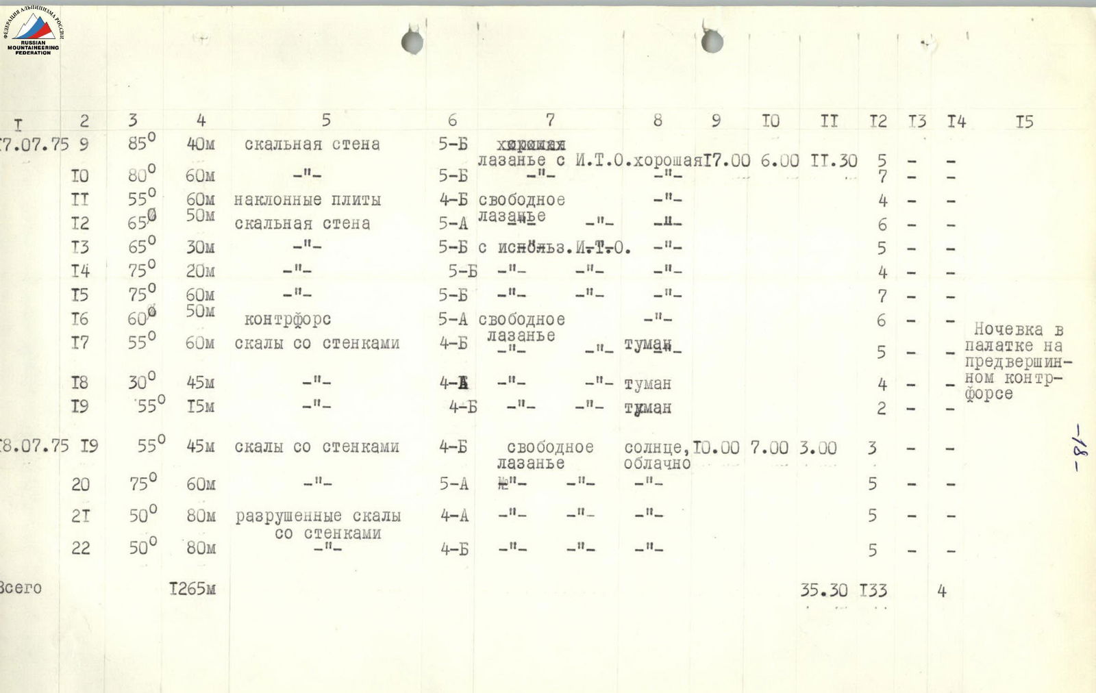
7. Table of route sections
Ascent to Main Amanauz peak via southwest wall
Height difference on the route - 960 m Including complex sections - 610 m Average steepness - 78°
| Date | Section | Steepness (°) | Length (m) | Relief characteristics | Category of difficulty | Method of overcoming | Weather conditions | Start time | End time | Working hours | Rock pitons | Ice pitons | Bolt pitons | Overnight stay |
|---|---|---|---|---|---|---|---|---|---|---|---|---|---|---|
| July 15, 1975 | R1 | 85 | 60 | rock wall | 5B | climbing using artificial aids | good | 7:00 | 16:30 | 10:30 | 8 | – | – | Bivouac in tent |
| R2 | 85 | 60 | – | 5B | – | – | 8 | – | – | Bivouac in tent | ||||
| R3 | 90 | 60 | smooth rock | 6 | – | – | 7 | – | – | on counterfort | ||||
| R4 | 85 | 60 | wall with overhang | 5B | – | – | 7 | – | – | |||||
| R5 | 80 | 60 | internal corner | 5B | free climbing | bad, fog, rain with snow | 6 | – | – | |||||
| July 16, 1975 | R6 | 70 | 80 | internal corner | 5B | free climbing | good | 12:00 | 17:00 | 10:00 | 5 | – | / | Hanging, in hammocks |
| R7 | 35 | 50 | simple rocks | 3B | – | – | 4 | – | – | |||||
| R8 | 80 | 60 | not clearly expressed counterfort | 5A | – | fog | 7 | – | – | |||||
| R9 | 85 | 20 | rock wall | 5B | climbing with artificial aids | – | 5 | – | – | |||||
| July 17, 1975 | R9 | 85 | 40 | rock wall | 5B | good climbing with artificial aids | good | 7:00 | 17:00 | 11:30 | 5 | – | – | |
| R10 | 80 | 60 | – | 5B | – | – | 7 | – | – | |||||
| R11 | 55 | 60 | inclined slabs | 4B | free climbing | – | 4 | – | – | |||||
| R12 | 65 | 50 | rock wall | 5A | climbing | – | 6 | – | – | |||||
| R13 | 65 | 30 | – | 5B | with artificial aids | – | 5 | – | – | |||||
| R14 | 75 | 20 | – | 5B | – | – | 4 | – | – | |||||
| R15 | 75 | 60 | – | 5B | – | – | 7 | – | – | |||||
| R16 | 60 | 50 | counterfort | 5A | free climbing | – | 6 | – | – | Bivouac in tent | ||||
| R17 | 55 | 60 | rocks with walls | 4B | – | fog | 5 | – | – | on pre-summit | ||||
| R18 | 30 | 45 | – | 4A | – | fog | 4 | – | – | counterfort | ||||
| R19 | 55 | 15 | – | 4B | – | fog | 2 | – | – | |||||
| July 18, 1975 | R19 | 55 | 45 | rocks with walls | 4B | free climbing | sun, cloudy | 7:00 | 10:00 | 3:00 | 3 | – | – | |
| R20 | 75 | 60 | – | 5A | – | – | 5 | – | – | |||||
| R21 | 50 | 80 | broken rocks with walls | 4A | – | – | 5 | – | – | |||||
| R22 | 50 | 80 | – | 4B | – | – | 5 | – | – | |||||
| Total | 1265 | 35:30 | 133 | 4 |
8. Route characteristics
The route, according to the group, is logical, interesting, and not prone to rockfall. It requires at least three days of complex, intense work on the wall. Preliminary wall processing is necessary, as there is no bivouac on the first 300 m. The upper part of the wall is like the bed of a hanging glacier. Therefore, the wall is monolithic, smoothed, with few footholds. The wall is a huge triangle with a chipped lower part. There is no water on the wall in good weather. The route is complex. All three bastions are climbed with ladders (9 sections). On several sections, only 2–3 ladders were hung.
Group members must have good rock climbing training.
The route can be recommended to sports groups for further improvement.
Length of sections:
90–85° — 300 m 85°–75° — 320 m 75°–60° — 210 m less than 60° — 435 m