Climbing Passport
- Type of ascent — rock climbing
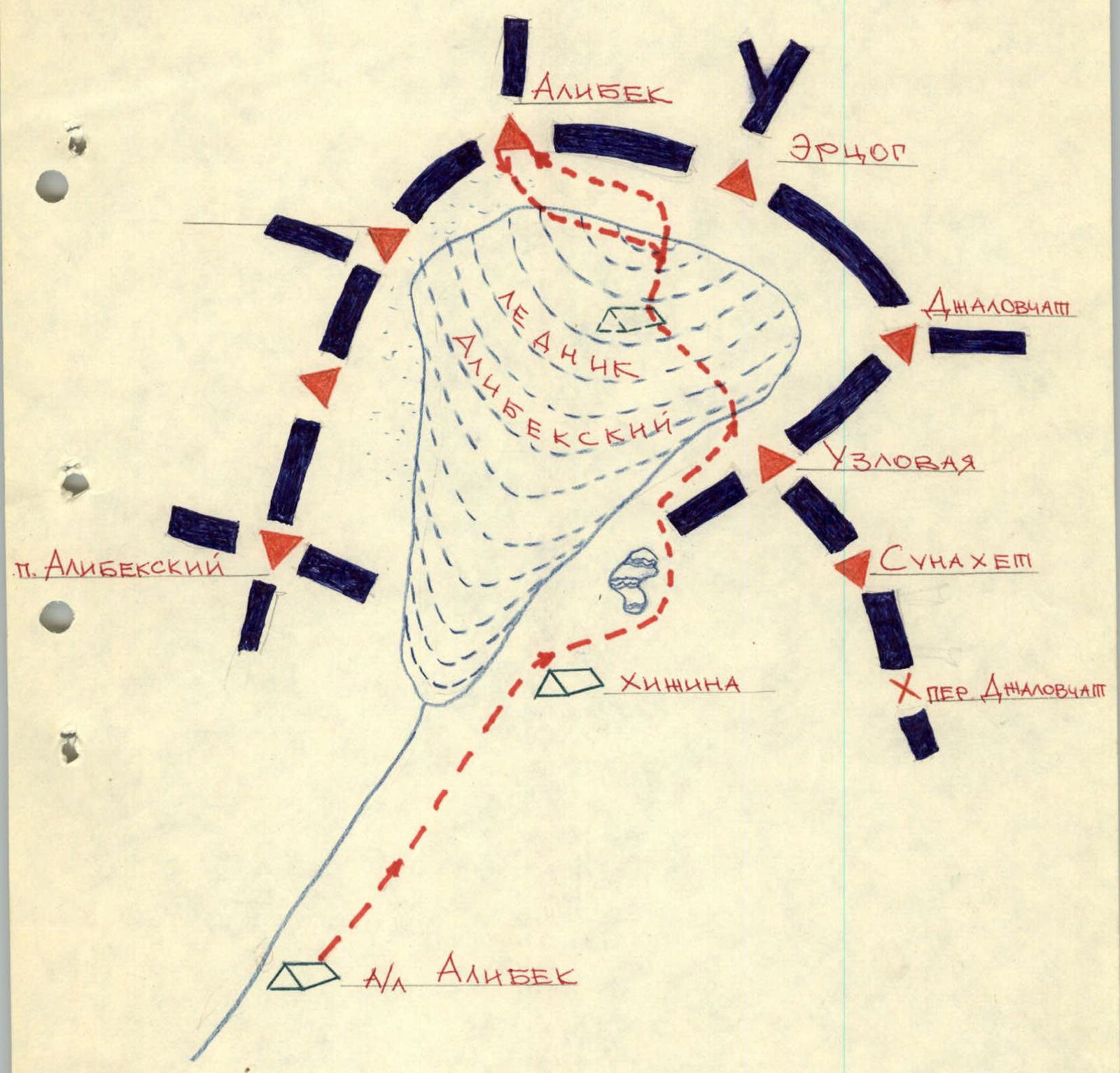
- Climbing area — Main Caucasus Range from Marukh pass to Nakhara pass (Western Caucasus)
- Peak, its height, Alibek-Bashi peak (3782 m). Ascent route via the North face
- Estimated difficulty category — 3B
- Route characteristics:
- Elevation gain — 420 m
- Average steepness — 60°
- Pitons hammered — 6 rock pitons
- Number of climbing hours — 8–9 hours
- Number of nights stayed — none
- Participants: Gerosota Ilya Fedorovich — 1st sports category Savenok Vadim Nikolaevich — 1st sports category
- Team coach — Kovalenko Yuri Ivanovich, Master of Sports of the USSR
TABLE OF MAIN ROUTE CHARACTERISTICS
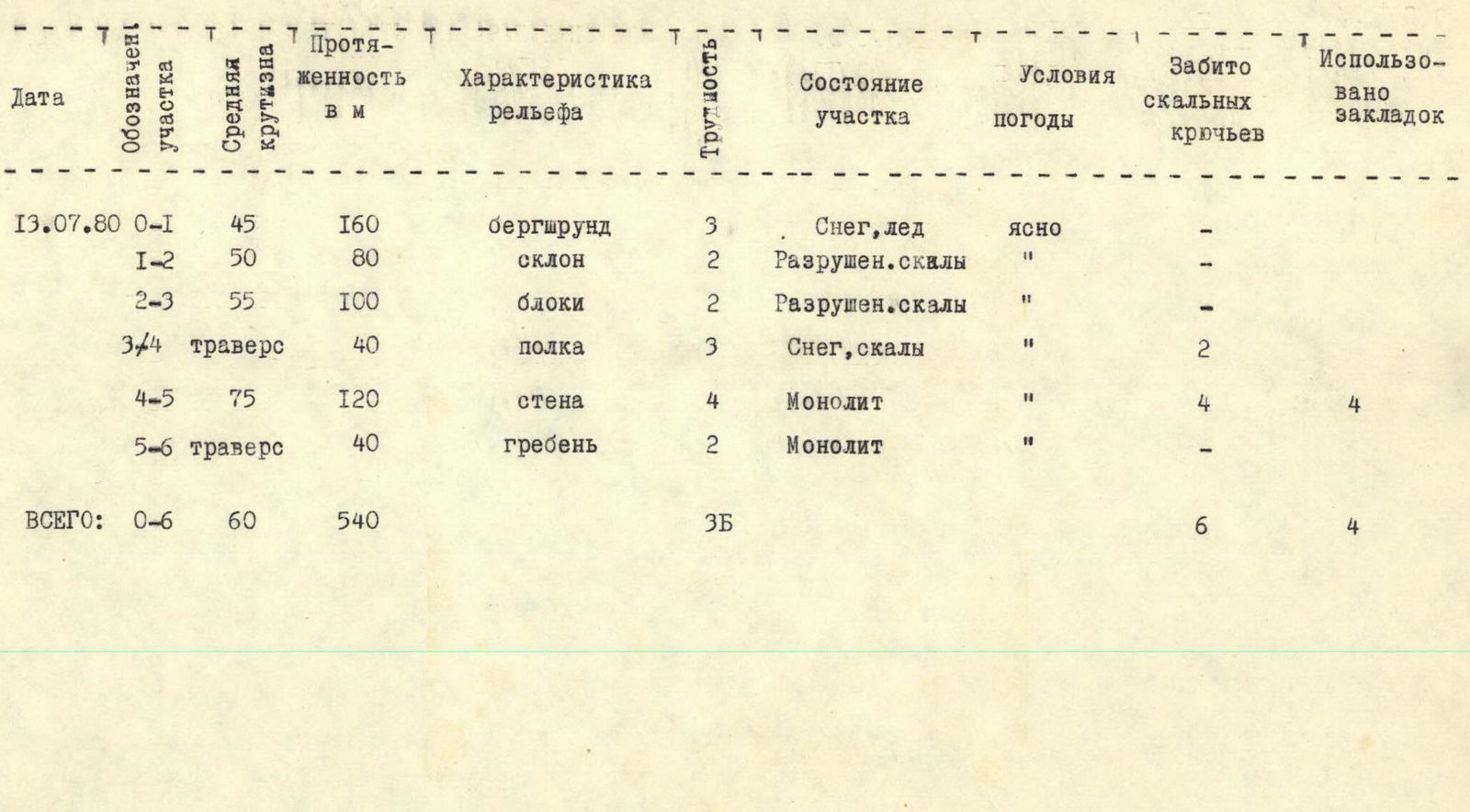
| Date | Section designation | Average steepness | Length, in m | Relief characteristics | Difficulty | Section condition | Weather conditions | Rock pitons hammered | Used chocks |
|---|---|---|---|---|---|---|---|---|---|
| July 13, 1980 | R0–R1 | 45 | 160 | Bergschrund | 3 | Snow, ice | clear | – | – |
| R1–R2 | 50 | 80 | slope | 2 | Destroyed rocks | " | – | – | |
| R2–R3 | 55 | 100 | blocks | 2 | Destroyed rocks | " | – | – | |
| R3–R4 | 40 | 40 | ledge | 3 | Snow, rocks | " | 2 | – | |
| R4–R5 | 75 | 120 | wall | 4 | Monolith | " | 4 | 4 | |
| R5–R6 | 40 | 40 | ridge | 2 | Monolith | " | – | – | |
| TOTAL: | R0–R6 | 60 | 540 | 3B | 6 | 4 |
BRIEF DESCRIPTION OF THE ROUTE
From "Alibek" tourist center along the trail past the hut, Turiy lakes — approach to overnight stays on the "ram's foreheads" under the slopes of Razdelny peak (2 hours).
From the overnight stays along the right (in the direction of travel) part of the Alibek glacier 300 m to the icefall. Here turn left and traverse 100–150 m under the icefall. Then to the right and upwards to the snow pad under the rocks of the northern ridge of Erzog peak. A bivouac is possible. Further to the left and upwards along the glacier to the northern wall of Alibek-Bashi peak. From the overnight stays on the "ram's foreheads" 3–5 hours.
Through the bergschrund along the snow and destroyed rocks 240 m to the western ridge of Alibek-Bashi peak under the tower of the northern wall. Movement is varied, insurance through an ice axe and ledges.
Further along the ledge to the left and upwards 100 m, bypassing the rock shoulder to the left. (To the right, it is not recommended to bypass the rock shoulder due to a plug in the chimney.) Simultaneous movement along the destroyed rocks to the shoulder. Here is a control cairn.
Further to the left and upwards along the horizontal ledge 40 m to the crevice in the middle of the wall and along it half a rope vertically upwards to the flake. Use pitons and chocks. From the flake 1 rope along the inner corner vertically upwards. Pitons insurance. Further 30 m to the gap in the ridge and along the wide chimney — exit to the summit ridge. Along it to the left 1 rope to the summit. From the bergschrund 4–5 hours.
Descent along the eastern ridge 3A difficulty category.
MAP SCHEME OF THE CLIMBING AREA