Severodonetsk Sports Club "Khimik"
UkrSSR Alpine Championship
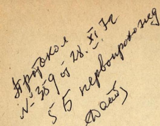
Report
On the first ascent of the Aksaut traverse with ascent via the East ridge to the Second Northern Aksaut and further traverse to the Eastern Aksaut (approximately route 5B cat. diff.)
July 14 – July 20, 1972
The ascent is dedicated to the 50th anniversary of the USSR formation
Severodonetsk – 1972
List of assault group participants
| № | Full name | Year of birth | Rank | Nationality | Party affiliation | Specialty | Place of residence |
|---|---|---|---|---|---|---|---|
| 1 | Optov Afanasiy Savel'evich | 1937 | CMS | Russian | CPSU | coach | Severodonetsk, Gagarina str. 74-a-21 |
| 2 | Paliy Ivan Nikolaevich | 1942 | CMS | Ukrainian | non-party | engineer | Severodonetsk, Donetskaya str. 58-17 |
| 3 | Krasnoshchekov Nikolay Alekseevich | 1932 | CMS | Russian | CPSU | senior research associate | Severodonetsk, Gagarina str. 8-a-43 |
| 4 | Boinov Mikhail Mikhailovich | 1931 | CMS | Russian | non-party | miner | Kadiyevka, Lobachevsky str. 58-59 |
| 5 | Ponomarev Eduard Vasil'evich | 1942 | I | Russian | non-party | electrician | Severodonetsk, Lisichanskaya str. 24-55 |
| 6 | Vorob'ev Dmitriy Gavrilovich | 1937 | I | Russian | non-party | fitter | Severodonetsk, Zavodskaya str. 27-12 |
Route description
July 14. The assault group of 6 people left Dombay clearing at 6:00 along with the support group. We followed the trail to the Turie Lake and further towards the Jalogvat pass. From the pass, we descended to the Jalogvat glacier. We crossed it towards the moraine. It took 7–8 hours from the Dombay clearing. We found a place to spend the night on the moraine. The rest of the day was spent examining the ascent route and the approach to the start of the route using binoculars. The weather was excellent. We decided to make a reconnaissance of the approach to the start of the route and carry some cargo on July 15.
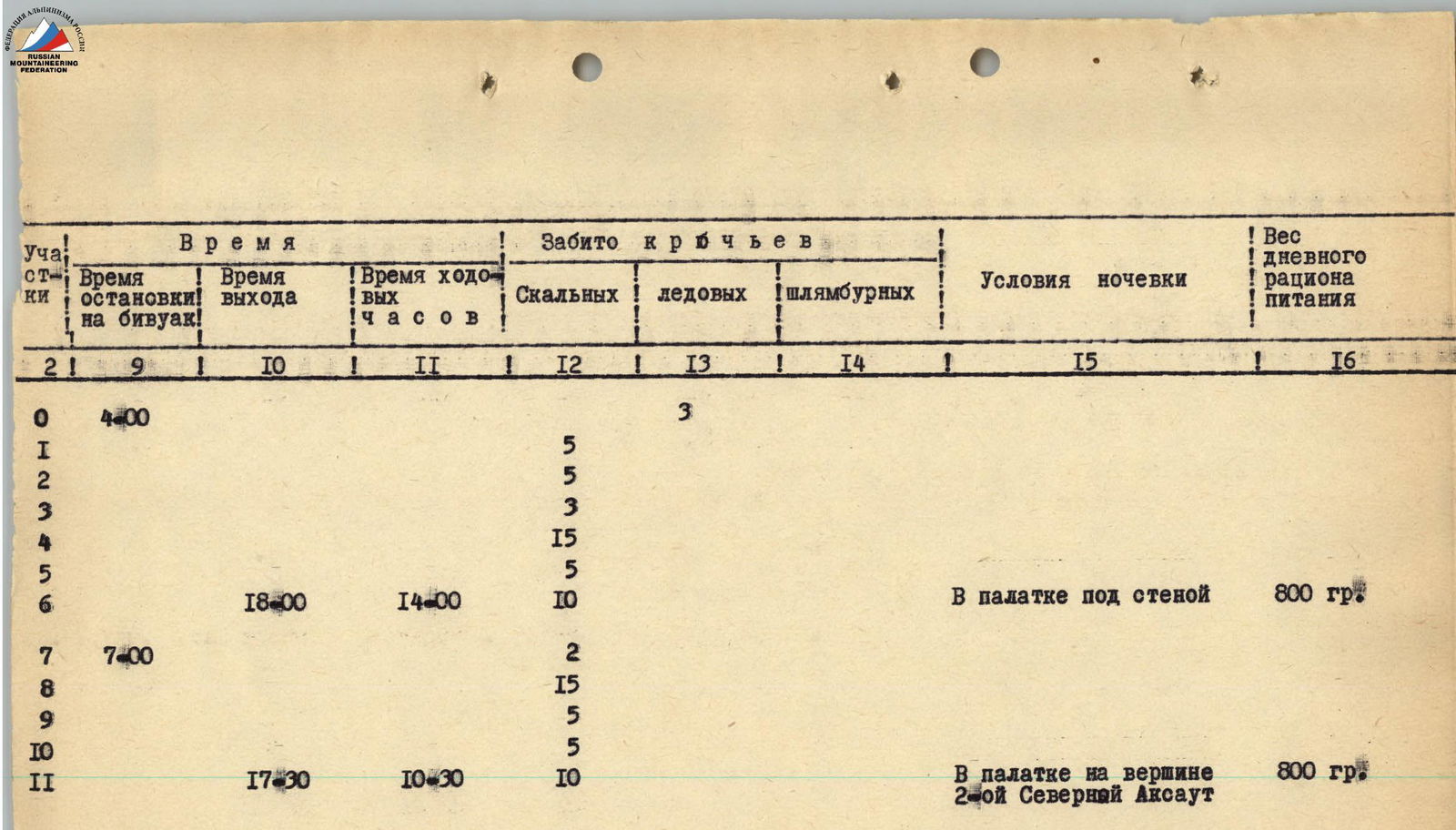
July 15. The support group left at 4:00 to make the usual traverse of Aksaut 5B cat. diff. from the north, while our group consisting of Optov A.S., Paliy I., Krasnoshchekov N., Vorob'ev D. left at 7:00. One rope team, Boinov M. and Ponomarev E., stayed at the night's halt. Our goal was to approach the start of the ridge and make a cache of food, gasoline, and equipment. We moved from the night's halt towards the clearly defined ridge of the North-Eastern Aksaut, descending to the glacier. We exited to the ridge via the right side of the ice couloir. It was necessary to pass it early in the morning. The first person went in crampons. The length of the ice couloir is two ropes, with piton belay. The section is exposed to rockfall and icefall up to the couloir for 1 hour of walking. From the North-Eastern ridge, we moved left along a snowy slope with a steepness of 30°–50°, exiting to a clearly defined rock island, which is located approximately in the middle of the glacier under the East ridge of the Second Northern peak. This section was passed below the icefalls, as an icefall could occur at any moment. We crossed the rock island; the rocks were easy, and exited to the glacier. Along the steep glacier, the first person in crampons with piton belay, we exited to the start of the East ridge. The landmark was a 20-meter waterfall to the right, with periodic rockfall, icefall, and water flow. It took 4 hours to reach the start of the route from the night's halt. We examined the route well, left food and equipment, and descended back to the night's halt. The main task of the group – reconnaissance of the approach to the start of the route and caching food supplies – was accomplished.
July 16. We left the night's halt at 4:00. The path was familiar and easy. We passed the ice couloir along previously fixed ropes. At 7:30, we approached the East ridge of the Second Northern Aksaut. We picked up our cache. We exited to the ridge via a 10-meter wall towards the waterfall to a sloping ledge. The belay was piton, with 7 pitons hammered. Climbing was difficult. Backpacks were pulled up. Further, we followed a 3-meter wall, traversing left along easy rocks towards a gap. This was the first control point. Moving along the ridge to the right led to a 4-meter wall, which was overcome using ladders. Further movement along the ridge was initially on the left side, then on the right. The rocks were difficult, with some sections of medium climbing difficulty. The ridge led to a wide wall with very small holds. Before reaching the wall, the ridge was exposed to rockfall. The length of the wall was 40 meters. We moved along the wall following a small stream. The wall's steepness was 50°–60°. The belay was piton. The first person went in galoshes. In the upper part of the wall, there was a large window, from which a ridge extended to the right. Movement along the ridge was on destroyed rocks, with climbing difficulty ranging from medium to easy. The ridge ended with a wall, under which a safe spot for the night's halt could be organized. The time was 18:00. This was where we planned to spend the night. It took 1 hour to prepare a spot for two tents. This was the second control point.
July 17. We left at 7:00. To the right of the wall, there was a snowy couloir, where rocks periodically fell. To exit back to the ridge, it was necessary to cross the couloir. We fixed ropes and quickly crossed the couloir one by one. Movement along the ridge was on very destroyed rocks, with climbing difficulty medium. The path followed the right (by the direction of travel) side of the ridge. The belay was piton. The movement led to a steep, narrow rock couloir. The steepness was 60°–70°. The length was 30 meters. The couloir was heavily destroyed and could not be bypassed. The first person passed it very carefully, fixing ropes. The belay was piton, with duralumin wedges going in well. The couloir was passed one by one. The couloir led to a 40-meter wall. There were many holds, and the belay was piton. Further, we traversed to the right along a narrow, destroyed ledge to a not clearly defined counterfort, along which we exited to the Second Northern Aksaut. The time was 17:30. We organized a night's halt on the summit. The support group was ahead of us, spending the night on the main peak. Communication with the base camp and the support group was excellent. The weather was good.
July 18. We left at 7:00. From the summit, we descended to the snowy saddle between the Second Northern and Uzlovoy Aksaut. The saddle steeply dropped to the east and west. The exit from the saddle to the rocks was very difficult. The wall of the Uzlovaya peak was approximately 140–150 meters:
- Initially, 30 meters straight up;
- then 15 meters;
- traverse to the right along a not clearly defined ledge and another 10 meters;
- straight up along an internal corner (piton belay, with some pitons used as footholds), the first person went without a backpack.
After passing the internal corner:
- traverse left-up 10–12 meters;
- then straight up 20 meters to a ledge;
- along the ledge, 15 meters traverse to the right;
- further 40 meters up-left to the summit ridge;
- and along it to the summit of Uzlovoy Aksaut (loose rocks, rockfall, belay).
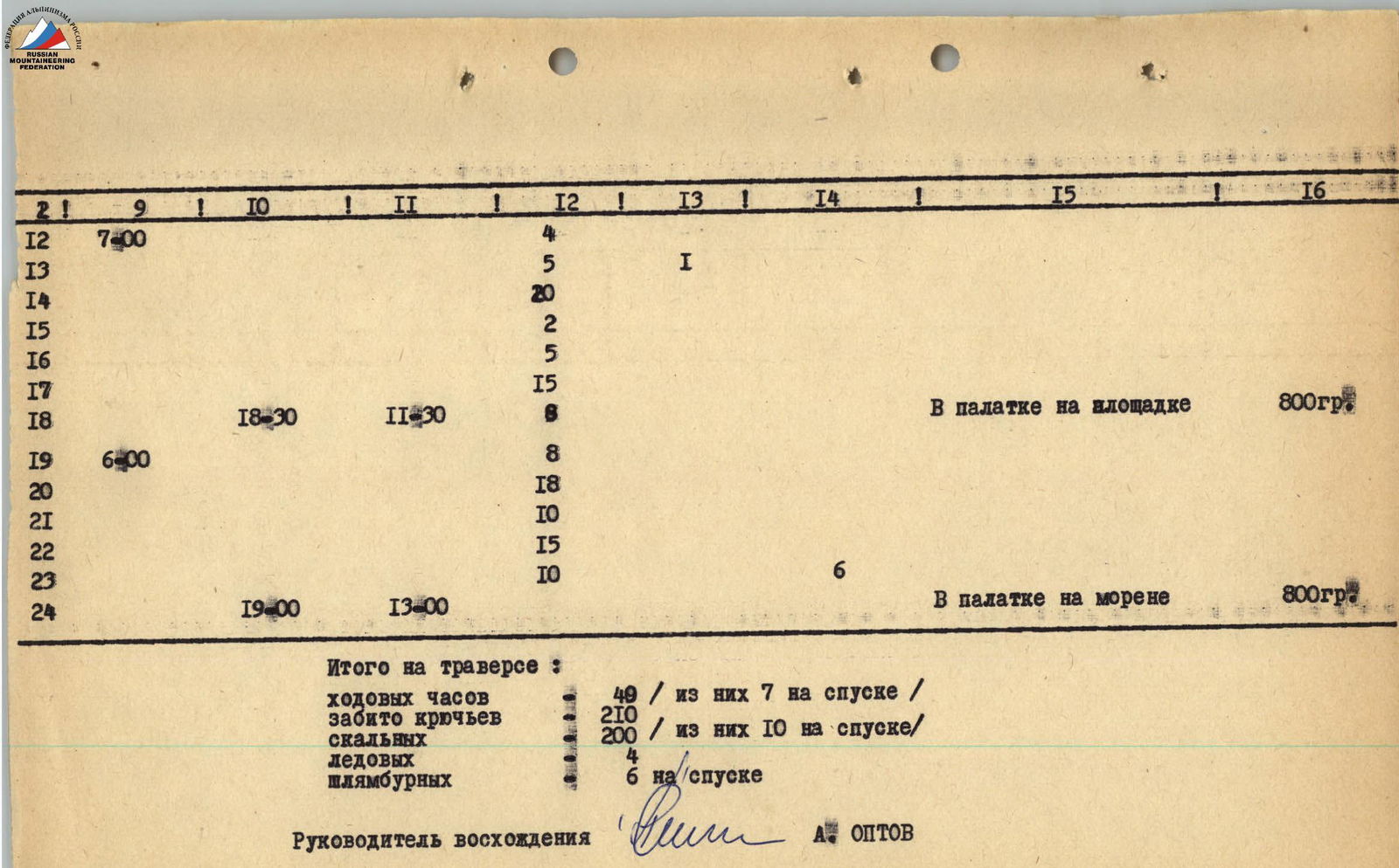
From the summit of Uzlovoy Aksaut, we could see almost the entire "saw" that led to the Eastern Aksaut. It was very long and sharp. Between the "saw" and the summit, there was a saddle. The descent to the saddle was one rope using free climbing, and one rappel. The exit to the "saw" was via a 30-meter wall – this was the only possibility. Ladders and wedges were used. The first person had to stand on a partner's shoulders and hammer a piton from an uncomfortable position to hang a ladder. The first person went without a backpack, in galoshes. The wall was climbed directly with piton belay. We exited to the first tooth of the "saw". The ridge turned out to be very peculiar and complex. It was formed by huge monolithic blocks overlapping each other like tiles. The entire ridge resembled a "saw" with many rock "teeth" – gendarmes. The "saw" was limited by steep, smooth walls. The exit to the second tooth of the "saw" was not very difficult, but there were many loose rocks, and the belay was piton. The descent was 30 meters using free climbing. The next two gendarmes were bypassed on the right (by the direction of travel) by traversing the wall along a ledge with piton belay. Movement was slow due to many loose rocks. The belay was piton. The ledge led to the exit to the next tooth, "Paltse" (Finger), overhanging towards us. After examining "Paltse" well, we decided to descend another 10 meters down and exit to "Paltse" via a 40-meter not clearly defined internal corner. The exit was very difficult. The first person went without a backpack, in galoshes. Here, we managed to pass with the help of ladders. The belay was piton. On "Paltse", there was the third control point. The time was 18:30. Below "Paltse" to the right (by the direction of travel), we made a spot for a night's halt for one tent, and for the rest – under an overhanging rock (semi-rocky halt). There was no water at the halt.
July 19. We left the night's halt at 6:00. Initially, movement was along the ridge, with rocks of medium difficulty. The ridge was very sharp, with piton belay. Again, we descended to the right (by the direction of travel), slightly below the ridge. In some places, the belay was simultaneous. The rocks seemed not very difficult. We moved cautiously – there were many loose rocks. We exited back to the ridge along a not steep snowy slope towards a large rock with a window. In front of us was a 50-meter monolithic wall with small holds. It was located to the left (by the direction of travel) and was sunlit. While a rope team processed the wall, the rest melted snow and prepared tea, as we encountered snow for the first time in the morning. The wall was climbed with piton belay; the first person went in galoshes without a backpack. Climbing was difficult and tense. Duralumin wedges went in well. After the wall, there was an easy ridge. Again, we bypassed the "saw" on the right (by the direction of travel) along destroyed rocks. Movement was simultaneous, with some difficult climbing sections. We exited to the pre-summit ridge via a 40-meter wall. Climbing was complex, with piton belay. The weather started to deteriorate. A bit more movement along the ridge, and we were on the summit of Eastern Aksaut. The time was 12:00. We removed a note left by instructors from "Alibek" alpine camp, who made an ascent to Eastern Aksaut via route 4A cat. diff. We left our own note and started the descent. The descent from the summit:
- Initially, 50–60 meters along the right side of the East ridge to a wide couloir;
- along the middle part of the wide couloir, leaving two narrow couloirs to the left, straight down to a large gap, staying closer to the right ridge (belay via outcrops and pitons);
- from the gap, along the left part of a steep, narrow couloir down to the Jalal-Abad glacier;
- descent to the glacier using rappel;
- along the glacier – movement towards the night's halt on the moraine.
The descent took 6–7 hours and was almost entirely exposed to rockfall. In some places, there were no cracks. We hammered 6 piton anchors during the descent. At the night's halt, we were met by the support group, which had already completed the usual traverse and was waiting for us. After spending the night at this halt, both groups returned to the Dombay clearing, the base camp of the Severodonetsk gathering, on July 20, 1972.
Table of main characteristics of the first ascent route
The route of the first ascent – traverse of Aksaut from the Second Northern to the Eastern peak – is approximately 5B cat. diff. The height difference of the route is 1000 meters. The steepness of the most difficult sections is 60°–90°.
| Date | Passed sections | Average steepness of the section | Length of the section | Characteristics of sections and conditions of their passage | by technical difficulty | by method of overcoming, by belay | by weather conditions |
|---|---|---|---|---|---|---|---|
| by relief character | |||||||
| July 16, 1972 | 0 | 20 | 2000 | glacier, rocks | easy rocks | clear | |
| 1 | 70–80 | 10 | wall | difficult climbing | piton belay | ||
| 2 | 60–70 | 40 | exit to the ridge | medium difficulty | - | ||
| 3 | 80–90 | 5 | short wall | difficult | use of ladders, piton | ||
| 4 | 50–60 | 200 | movement along the ridge | medium difficulty | piton | ||
| 5 | 60–70 | 40 | wide wall | difficult | - | ||
| 6 | 40–50 | 200 | movement along the ridge | medium difficulty | - | ||
| July 17, 1972 | 7 | 40–50 | 45 | snowy pass | piton | clear | |
| 8 | 50–60 | 200 | ridge | medium difficulty | - | ||
| 9 | 60–70 | 30 | rocky couloir | difficult | - | ||
| 10 | 60–70 | 40 | wall | medium difficulty | - | ||
| 11 | 50–60 | 185 | movement along the ridge | medium difficulty | - | ||
| July 18, 1972 | 12 | 80 | descent from the summit by rocks | medium difficulty | piton | clear | |
| 13 | 10–15 | 80 | snowy-icey saddle | crampons | - | ||
| 14 | 70–80 | 150 | wall on Uzlovaya peak | difficult climbing | - | ||
| 15 | 60–70 | 80 | descent by rocks to the saddle | medium difficulty | - | ||
| 16 | 70–80 | 30 | wall | difficult | use of ladders, piton | ||
| 17 | 60–70 | 300 | movement along the right side of the ridge | medium difficulty | piton | ||
| 18 | 70–80 | 40 | exit to "Paltse" via an internal corner | difficult | - | ||
| July 19, 1972 | 19 | 50–60 | 80 | movement along the ridge | medium difficulty | piton | clear |
| 20 | 50–60 | 300 | movement along the right side of the ridge | medium difficulty | - | ||
| 21 | 70–80 | 40 | wall | difficult | - | ||
| 22 | 50–70 | 200 | pre-summit ridge, short wall | rocks of medium difficulty, piton | - | ||
| 23 | 30–80 | descent from the summit to the glacier via a couloir | medium difficulty | piton via outcrops | |||
| 24 | movement along the glacier to the night's halt on moraine |
July 20, 1972. Return to the base camp on the Dombay clearing.
Ascent leader A. Optov