Central Council of DSO "Spartak"
Alpinist National Team
Report
On the Ascent to Main Aксаут via the North Face
July 17–22, 1961
1. Aксаут Massif and its North Face.
(Geographical location and history of exploration) The Aксаут massif is located west of the popular Dombay region and, together with the Кара-Каи massif and the spurs of Джаловчат, closes the picturesque Aксаут valley.
The Aксаут node consists of 9 peaks, among which the most significant alpinist interest is drawn to:
- Узловая (3860 m)
- Средняя (3870 m)
- Главная (3900 m)
The Aксаут massif is extremely unique from the north — smooth, completely sheer walls rise directly from the Aксаут glacier cirque, divided in the middle by a steep hanging glacier. These walls are crowned by several pointed peaks located very close to each other and separated by shallow saddles. The height of the northern walls vertically (difference in elevation) is 1100–1300 m. According to our data, based on altimeter readings, the elevation of the Main peak above the glacier cirque, measured from the beginning of the wall, is 1200 m. The North face of the Main peak drops in three sheer and often overhanging steps, each 250–350 m high; the lower step is separated from the middle by an icy rock slope with a steepness of 70–85°, and the middle from the upper — by a steep and very complex ridge composed of large blocks and slabs. The upper sheer step is heavily glaciated.
The uniqueness of the Aксаут massif is largely determined by its geological structure. According to research by participants of the 1959 and 1961 expeditions, candidates of geological and mineralogical sciences Yu.P. Melnik and Yu.V. Kononov, Aксаут, unlike most peaks in the Caucasus, is composed of monolithic, durable rocks:
- diorites,
- syenites,
- very rare amphibole rocks — hornblendites.
These massive, weakly weathered rocks form the sheer black northern walls of Aксаут. To the west and south, the area is composed of less durable migmatites and gneisses, against which the Aксаут massif stands out sharply.
Although to the west of the Aксаут region glaciation decreases sharply and peaks worthy of alpinist attention are practically absent, as we observed during a trip to the upper reaches of Arkhyz, Aксаут itself is characterized by very intense glaciation with powerful firn fields. The low position of the snow line (approximately 2800 m) and the isolation of the Aксаут glacier cirque determine a more severe microclimate in the region compared to Dombay; ascents here are complicated by:
- strong westerly winds blowing from the Чхалта valley,
- a significant number of cloudy days.
Overall, the North Aксаут cirque and the glaciated northern walls of Aксаут make a profound impression. In the opinion of all group members and based on observations from 1959 and 1961, climbing conditions in this region are close to those of the Central Caucasus.
Unlike the well-developed Dombay, the Aксаут node is visited by only a few alpinist groups, and these visits typically take the form of short excursions from the Dombay region. To date, a number of interesting routes remain unattempted:
- traversing Aксаут from east to west along the main Caucasian ridge,
- traversing from the west,
- the western walls of Кара-Каи, among others.
Repetitions of previously climbed complex routes are counted in units. This is not due to a lack of sufficiently complex and interesting alpinist objectives but rather the insufficient exploration and inaccessibility of the region. Serious ascents in Aксаут can only be undertaken by organizing a special expedition well-equipped with provisions and gear and based in the Aксаут valley (175 km from Dombay on mountain roads).
The history of alpinist exploration of Aксаут is relatively straightforward.
- The first ascent to Main Aксаут via the easiest route from the south (2B) was made in 1935 by a group led by V. Naumenko. This route was subsequently repeated multiple times.
- The first attempt to traverse Aксаут from east to west was made by a group led by V. Budanova (1948), which managed to reach only the Узловая peak (5A).
- The complete traverse of the massif from the north (5B), including the Main peak, was accomplished in 1952 by a group led by S. Kalinkin and later repeated by several other groups.
No attempts were made to ascend the peaks of the Aксаут massif via the northern walls of the Aксаут glacier cirque until 1959. The renowned expert on the Aксаут region, N.M. Popov, considered ascents up the Aксаут north faces impossible due to the steepness and specific structure of the rocks, conditioned by the monolithic nature of the formations, the presence of smooth sheer and overhanging walls, and vertical slabs (yearbook "Pobezhdennye vershiny" [Conquered Peaks], year 1950).
The first attempt to ascend Main Aксаут via the north face was made in 1959 by a group of Ukrainian alpinists consisting of:
- Yu. Melnik (leader),
- G. Aprelenko,
- Yu. Kononov,
- V. Yakovina.
They managed to overcome only the first — lower — sheer step and reach the overhanging rocks of the second step. Here, the group was forced to abandon the ascent due to V. Yakovina's fall while attempting to pass a very difficult section at the lower part of the second step. The piton protection was reliable, but the injury sustained by the faller upon hitting a ledge prevented the group from continuing.
No further attempts were made to climb the wall, although in the 1960 season, several Dombay alpinist groups prepared to attempt the route.
II. Preparation, reconnaissance, ascent plan, and execution
The experience of the 1959 attempt showed that the route presented significant difficulty and required special preparation and equipment. Many sections were impassable without the use of artificial footholds, necessitating a sufficient supply of special pitons (including expansion bolts), wooden and duralumin wedges for wide cracks. The issue of footwear was particularly critical.
List of participants in the assault group
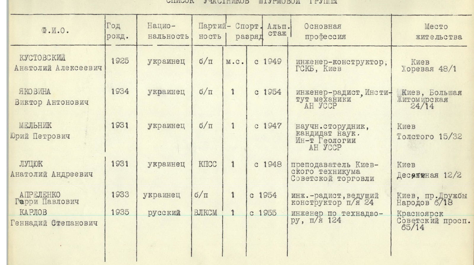
| Name | Year of birth | Nationality | Party affiliation | Sport rank | Alpinism experience | Main profession | Place of residence |
|---|---|---|---|---|---|---|---|
| Кустовский Анатолий Алексеевич | 1925 | Ukrainian | Non-party | Master of Sports | Since 1949 | Design engineer, GSKB, Kiev | Kiev, Khorevaya 48/1 |
| Яковина Виктор Антонович | 1934 | Ukrainian | Non-party | 1st sports rank | Since 1954 | Radio engineer, Institute of Mechanics, Ukrainian SSR | Kiev, Bolshaya Zhytomyrskaya 24/14 |
| Мельник Юрий Петрович | 1931 | Ukrainian | Non-party | 1st sports rank | Since 1947 | Research scientist, candidate of sciences, Institute of Geology, Ukrainian SSR | Kiev, Tolstogo 15/32 |
| Луцюк Анатолий Андреевич | 1931 | Ukrainian | CPSU | 1st sports rank | Since 1948 | Lecturer, Kiev Technical School of Soviet Trade | Kiev, Desyatynna 12/2 |
| Апреленко Гарри Павлович | 1933 | Ukrainian | Non-party | 1st sports rank | Since 1954 | Radio engineer, lead designer, p/o №24 | Kiev, pr. Druzhby Narodov 6/18 |
| Карлов Геннадий Степанович | 1935 | Russian | Komsomol | 1st sports rank | Since 1955 | Technical supervisor, p/o №124 | Krasnoyarsk, Sovetsky prospect 65/14 |
Description of the ascent
July 17. Departure to the wall at 7:00.
The wall begins immediately. Through a rannifty (ice crust) on a snow plug, we exit onto a narrow ledge under an overhang. Directly above is a monolithic sheer wall (R1–R3). From the first meters, we realize that we need to climb without backpacks and with full exertion. The exit via the overhanging upper part of the wall to the outer corner, where we hung 2 ladders, is particularly challenging.
The outer corner (R3–R4) is formed by large blocks with rare wide cracks and leads to a narrow shelf. The entire group assembles here, and the backpacks are pulled up in two stages.
To the right, a completely smooth, sheer outer corner with overhangs ascends. The path is found to the left of the corner along a discontinuous crack, also leading to an overhang. Again, very difficult climbing without backpacks (R4–R5).
Ahead lies the key site of the lower part of the first step — a two-meter cornice. On the left part, the cornice only slightly overhangs, and we manage to traverse there using a platform and ladders, having drilled 2 expansion bolts.
Overcoming this 3-meter section of overhanging, smooth rocks required almost 1.5–2 hours of intense work (R5–R6).
Further, directly up the sheer slabs to a vaguely expressed inner corner (R6–R7). The slabs have few cracks and small but firm holds. Upon exiting the corner, a ladder is hung. Along the inner corner, composed of similarly smooth monolithic rocks, we ascend to
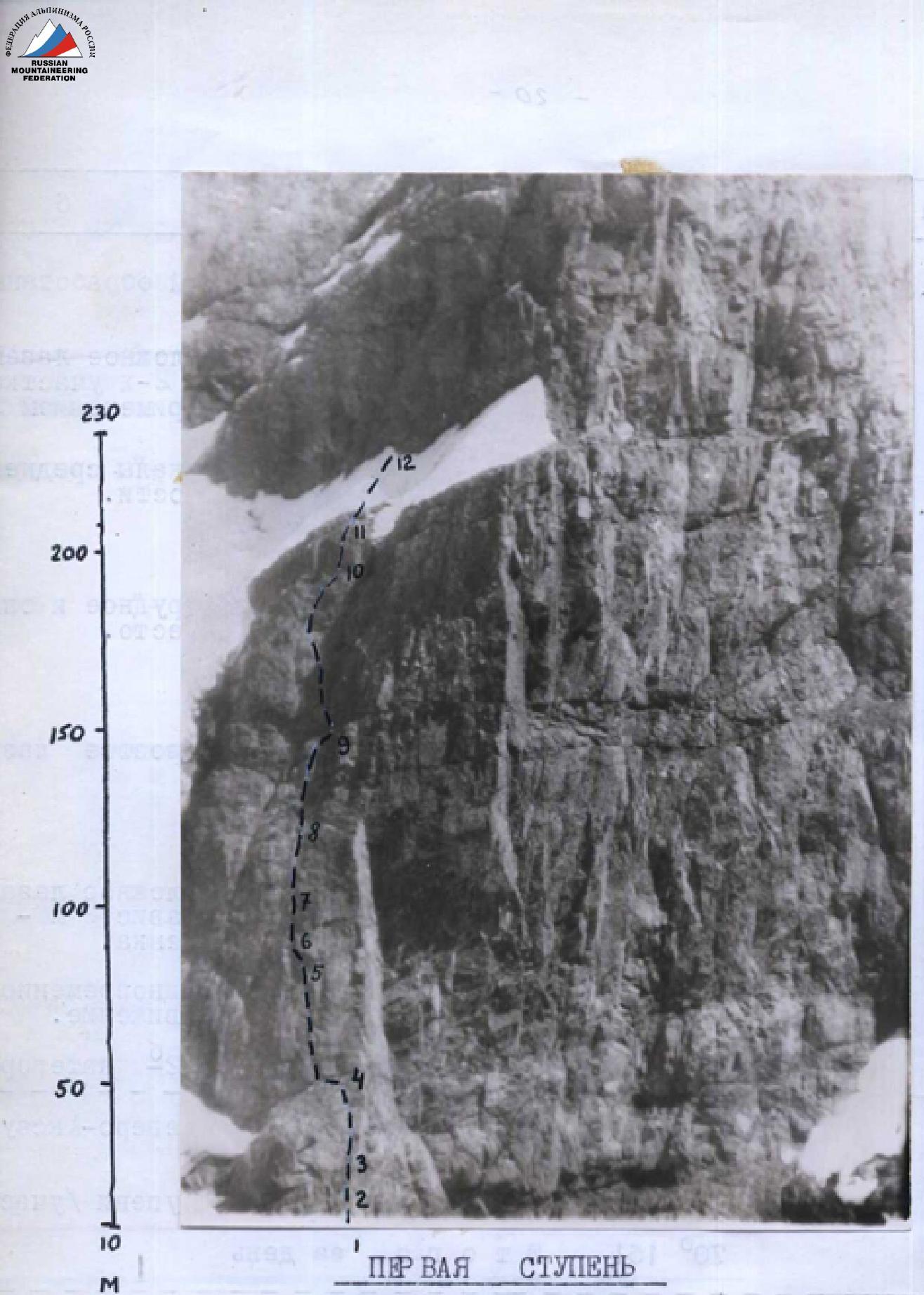 FIRST STEP. Photographed with a telephoto lens from the slopes of V. Brattsev.
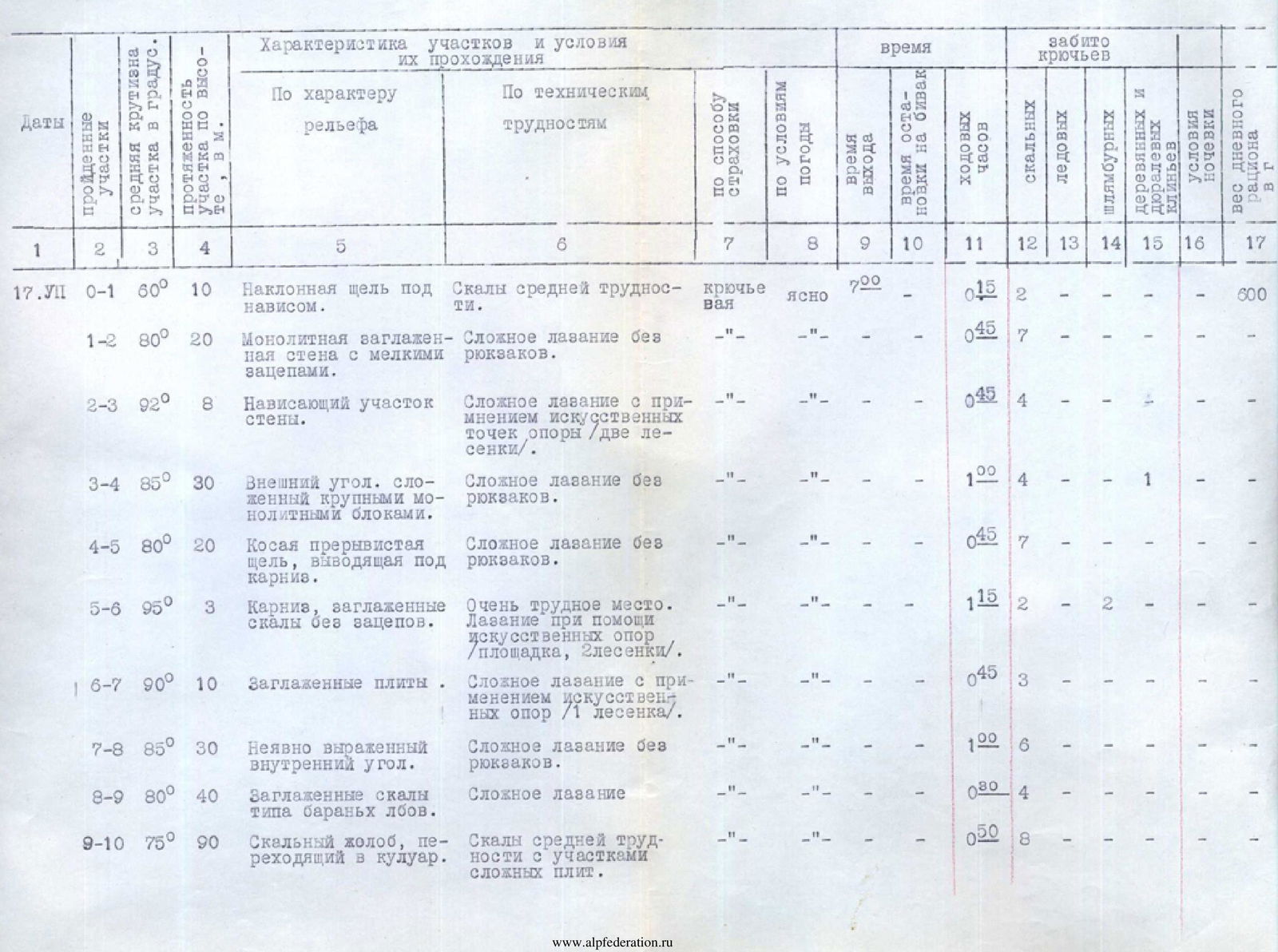
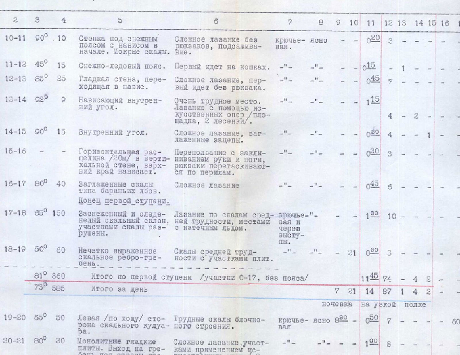
| Dates | Sections traversed | Average steepness of section in degrees | Height of section in meters | Characteristics of sections by relief | Characteristics of sections by technical difficulty | Time: By protection method | Time: By weather conditions | Time: Departure time | Time: Stop at bivouac | Time: Climbing hours | Pitons driven: Rock | Pitons driven: Ice | Pitons driven: Expansion bolts | Pitons driven: Wooden and duralumin wedges | Conditions of overnight stay | Weight of daily ration, in grams |
|---|---|---|---|---|---|---|---|---|---|---|---|---|---|---|---|---|
| 17.07 | R0–R1 | 60° | 10 | Inclined crack under overhang. | Rocks of medium difficulty. | Piton protection | Clear | 7:00 | 0:15 | 2 | 600 | |||||
| R1–R2 | 80° | 20 | Monolithic smooth wall with small holds. | Difficult climbing without backpacks. | 0:45 | 7 | ||||||||||
| R2–R3 | 92° | 8 | Overhanging section of wall. | Difficult climbing with use of artificial holds (2 ladders). | 0:45 | 4 | 1 | |||||||||
| R3–R4 | 85° | 30 | Outer corner composed of large monolithic blocks. | Difficult climbing without backpacks. | 1:00 | 4 | ||||||||||
| R4–R5 | 80° | 20 | Discontinuous crack leading under cornice. | Difficult climbing without backpacks. | 0:45 | 7 | ||||||||||
| R5–R6 | 95° | 3 | Cornice, smooth rocks without holds. | Very difficult section. Climbing with artificial supports (platform, 2 ladders). | 1:15 | 2 | 2 | |||||||||
| R6–R7 | 90° | 10 | Smooth slabs. | Difficult climbing with use of artificial holds (1 ladder). | 0:45 | 3 | ||||||||||
| R7–R8 | 85° | 30 | Vaguely expressed inner corner. | Difficult climbing without backpacks. | 1:00 | 6 | ||||||||||
| R8–R9 | 80° | 40 | Smooth rocks like "ram's foreheads". | Difficult climbing. | 1:20 | 4 | ||||||||||
| R9–R10 | 75° | 90 | Rock gully transitioning into a couloir. | Rocks of medium difficulty with sections of difficult slabs. | 0:50 | 8 | ||||||||||
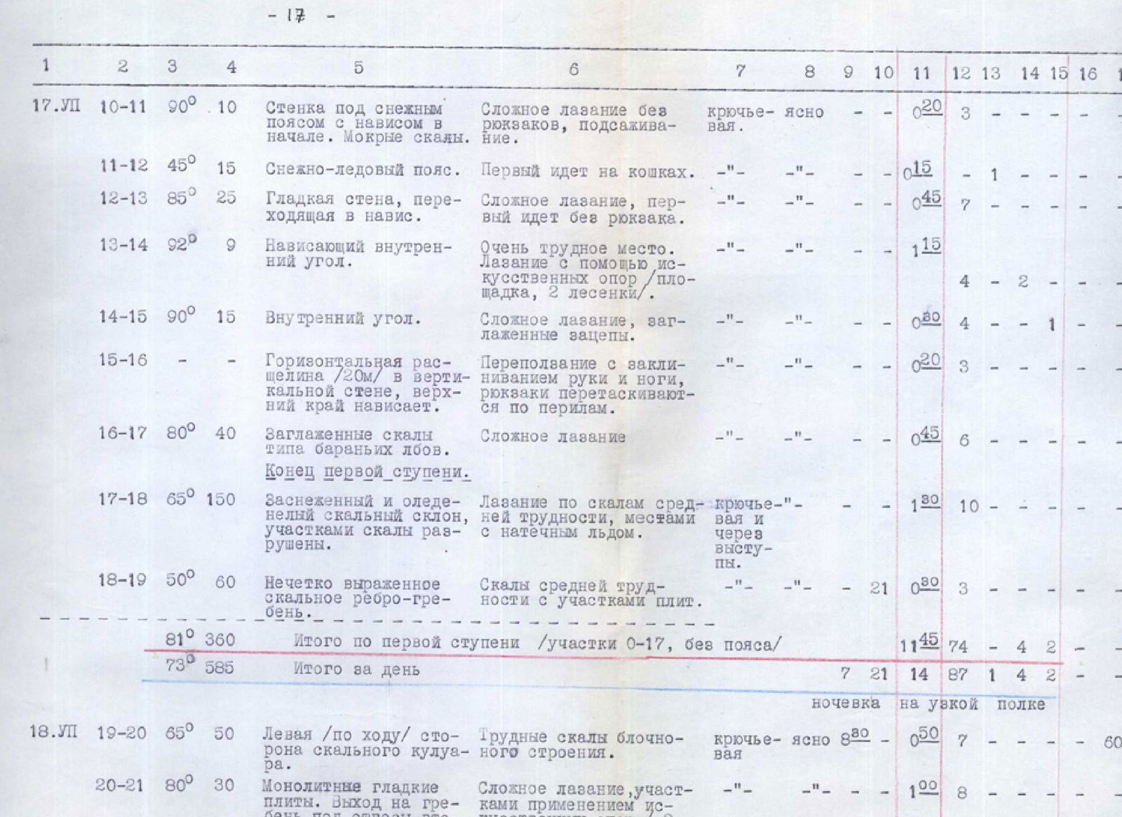
| R10–R11 | 90° | 10 | Wall under snow belt with overhang at start. Wet rocks. | Difficult climbing without backpacks, boosting. | Piton protection | Clear | 0:20 | 3 | ||||||||
| R11–R12 | 45° | 15 | Snow-ice belt. | First climber on crampons. | 0:15 | 1 | ||||||||||
| R12–R13 | 85° | 25 | Smooth wall transitioning into overhang. | Difficult climbing, first climber without backpack. | 0:45 | 7 | ||||||||||
| R13–R14 | 92° | 9 | Overhanging inner corner. | Very difficult section. Climbing with artificial supports (platform, 2 ladders). | 1:15 | 4 | 2 | |||||||||
| R14–R15 | 90° | 15 | Inner corner. | Difficult climbing, smooth holds. | 0:20 | 4 | 1 | |||||||||
| R15–R16 | Horizontal crack (20 m) in vertical wall, upper edge overhangs. | Climbing with wedging hands and feet, backpacks pulled up on perches. | 0:20 | 3 | ||||||||||||
| R16–R17 | 80° | 40 | Smooth rocks like "ram's foreheads". End of first step. | Difficult climbing. | 0:45 | 6 | ||||||||||
| R17–R18 | 65° | 150 | Snow-covered and icy rock slope, sections of rocks destroyed. | Climbing rocks of medium difficulty, местами with icing. | Piton protection | 1:30 | 10 | |||||||||
| R18–R19 | 50° | 60 | Vaguely expressed rock ridge-crest. | Rocks of medium difficulty with sections of slabs. | 1:20 | 3 | ||||||||||
| 81° | 360 | Total for first step (sections R0–R17, excluding belt) | 11:45 | 74 | 1 | 4 | 2 | |||||||||
| 73° | 585 | Total for the day | Clear | 7:21 | 14:87 | 14:87 | 1 | 87 | 1 | 4 | on narrow ledge | 600 | ||||
| 18.07 | R19–R20 | 65° | 50 | Left side (by route) of rock couloir. | Difficult rocks of blocky structure. | Piton protection | Clear | 8:00 | 0:50 | 7 | 600 | |||||
| R20–R21 | 80° | 30 | Monolithic smooth slabs. Exit to ridge under sheer second step. | Difficult climbing, sections with artificial holds (2 ladders). | 1:00 | 8 | ||||||||||
| R21–R22 | 95° | 4 | Beginning of second step. Short overhanging wall. | Use of artificial holds (1 ladder). All climb without backpacks. | Piton protection | Clear | 0:20 | 3 | ||||||||
| R22–R23 | 90° | 15 | Vertical crack. Difficult rocks. | Climbing without backpacks with wedging hands and feet. | 0:40 | 6 | ||||||||||
| R23–R24 | 92° | 10 | Overhanging rock "forehead" of monoliths. | Difficult climbing without backpacks, with use of artificial holds (3 ladders). | 1:20 | 4 | 2 | |||||||||
| R24–R25 | 90° | 15 | Smooth wall with few holds. | Difficult climbing without backpacks with use of artificial holds (3 ladders). | 1:00 | 6 | 1 | |||||||||
| R25–R26 | 85° | 20 | Vaguely expressed inner corner leading to a large one. | Very difficult section. Climbing without backpacks, sections with artificial holds (platform, 2 ladders). | 2:15 | 7 | 2 | |||||||||
| R26–R27 | 85° | 25 | Slab with crack transitioning into overhang. | Difficult climbing without backpacks, wedging hands. | 1:15 | 4 | 3 | |||||||||
| R27–R28 | 85° | 20 | Large blocky rocks of medium difficulty. | Traverse right along narrow ledges with good holds. | 0:20 | 4 | ||||||||||
| R28–R29 | 95° | 12 | Diagonal crack in monolithic overhanging slabs leading to balcony. | Very difficult section. Climbing along crack with artificial supports (3 ladders on wedges). | 3:00 | 3 | 3 | |||||||||
| R29–R30 | 75° | 50 | Rock slope. Rocks represented by large blocks with narrow ledges. End of second step. | Rocks of medium difficulty. | 1:00 | 7 | ||||||||||
| 85° | 171 | Total for second step (sections R21–R30) | 9:40 | 44 | 2 | 9 | ||||||||||
| 80° | 251 | Total for the day (sections R19–R30) | Clear | 8:00 | 21:00 | 12:20 | 59 | 2 | 9 | on comfortable ledge on shoulder of second step | 600 | |||||
| 19.07 | R30–R31 | Horizontal wide ledge on western side of ridge. | Easy section, simultaneous movement. | Clear | 7:00 | 0:10 | 600 | |||||||||
| R31–R32 | 70° | 30 | Rock gully leading behind "gendarme"-ridge. | Rocks of medium difficulty. | Piton protection | 0:50 | 6 | |||||||||
| R32–R33 | 45° | 65 | Ridge composed of monolithic blocks, местами with sheer and overhanging walls. | Difficult climbing, sections with artificial holds (3 ladders, 2 on wedges). | 4:00 | 14 | 2 | |||||||||
| R33–R34 | Snow cornice. Beginning of third step. | Easy section. | Clear | 13:00 | 0:10 | |||||||||||
| R34–R35 | 75° | 15 | Edge between NE and NW walls of summit tower. | Difficult climbing (1 ladder). | Piton protection | 0:50 | 6 | 1 | ||||||||
| R35–R36 | 80° | 25 | NE wall of summit tower. Smooth monolithic rocks, rime ice. | Very difficult section. Climbing with artificial holds (platform, 3 ladders). | 3:00 | 9 | 1 | |||||||||
| 60° | 135 | Total for the day | 7:00 | 17:00 | 9:00 | 35 | 3 | 1 | ||||||||
| 20.07 | R36–R37 | 85° | 55 | NE wall of summit tower. Monolithic rocks, rime ice. | Continuation of processing. Difficult climbing with sections using artificial holds (5 ladders). | Piton protection | Cloudy, snow | 14:00 | 17:00 | 4:20 | 14 | 2 | 600 | |||
| 85° | 55 | Total for the day | 14:00 | 17:00 | 4:20 | 14 | 2 |
 UPPER PART OF FIRST STEP. Snow-ice belt and wall above it. Photographed in profile from NE ridge (by Kononov's group).
 FIRST STEP. Wall above belt. Schematic drawing.
Schematic drawing. A small ledge (R7–R8). Here again, we organize a two-stage pulling up of backpacks with a changeover on ladders under the cornice. This segment (R4–R8) at the lower part of the step, spanning over 60 m, is the most complex.
From the ledge, the wall becomes somewhat gentler (80°) and gradually transitions into a steep rock gully-couloir (R8–R9). The rocks are smooth, like "ram's foreheads". From here, it's possible to climb with backpacks, movement is alternating, and piton protection is used. The gully consists of a series of ledges-falls, местами with slabs. In the upper part of the gully, the steepness gradually increases and transitions into a sheer under the snow belt (R9–R11). The lower completely smooth section of this sheer was first climbed with the help of boosting. The rocks here are wet and slippery.
The snow belt was climbed without difficulty by the first climber on crampons; the rest ascended with top-rope protection along the ready-made steps (R11–R12).
From the snow belt upwards is a sheer wall (R12–R13), again requiring the removal of backpacks. The rocks, as before, are monolithic with few smooth holds. Initially, progress is somewhat eased by a vertical crack where pitons can be driven, then it disappears, and the wall transitions into a vaguely expressed overhanging inner corner (R13–R15). Here, progress is only possible with the help of a platform and an expansion bolt. The exit from the corner to a horizontal crack through an overhanging ledge is also very challenging (ladders). The 50-meter wall turned out to be the most difficult in the upper
 ROCK SLOPE BETWEEN FIRST AND SECOND STEPS. Photographed from NE ridge (by Kononov's group).
part of the first step, taking 2.5 hours to overcome. Above the crack, the wall overhangs steeply, so we traverse left along the horizontal crack, wedging hands and feet. After 15–18 meters, the crack transitions into a ledge (R15–R16), where the entire group finally assembles. This is the first place on the wall where a semi-reclined bivouac can be set up.
Without delaying on the ledge, we head up along steep rocks like "ram's foreheads" (R16–R17). The overcoming of the first step, which required almost 12 hours of complex, strenuous work, is completed. Further, a relatively gentle (65°) snow-covered and icy rock slope follows. The rocks are of medium difficulty, the pace of movement increases, although often we have to clear holds from snow and ice. Along the slope, we ascend to a vaguely expressed rock rib and then move along the rib to the left (R17–R19). We quickly pass this section and by 21:00 reach a ledge where the overnight stay was planned. The ledge had to be cleared of a thick layer of ice, but within an hour, the tent was set up, and a hot dinner was ready.
July 18. Departure at 8:00. The path goes along the left (by route) side of the rock couloir (R19–R20). Despite a relatively low steepness (65°), climbing is difficult — many monolithic boulders forming small walls need to be passed. The couloir gradually becomes steeper and transitions into a sheer rock gully, which leads to a saddle at the beginning of the second step. The right (by route) side of the gully is a monolithic overhanging wall, and the exit to the col is only possible along the left side via steep slabs (R20–R21). The exit via the slabs is very challenging, with a 2-meter overhanging section climbed on ladders.
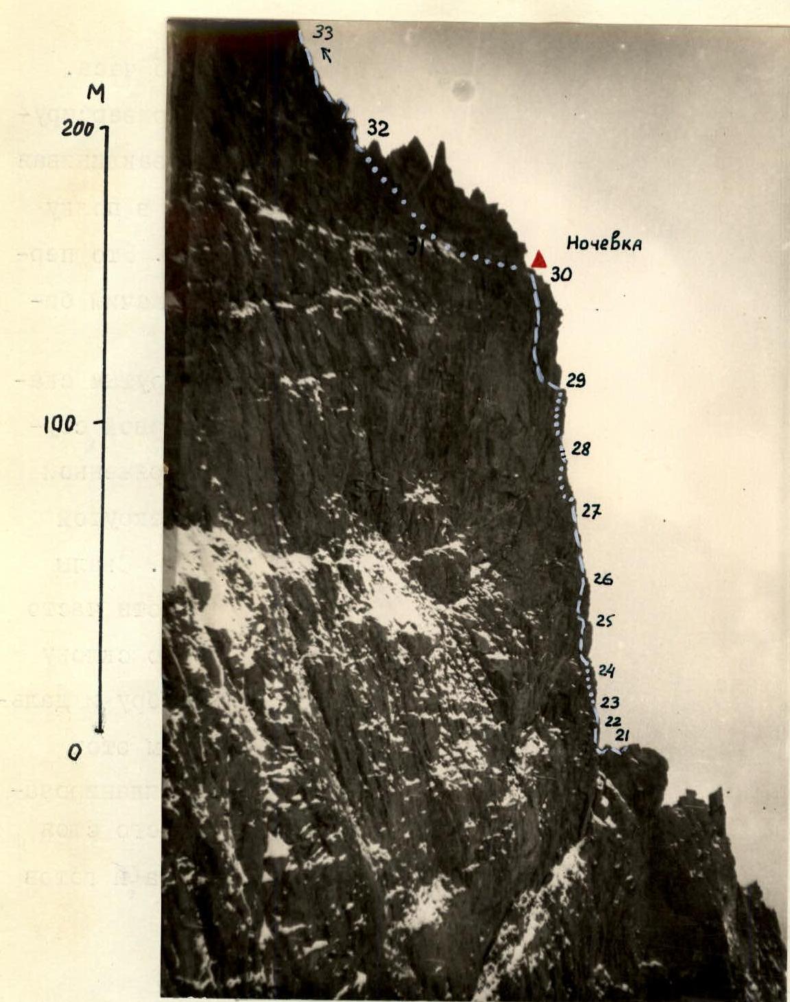
From the saddle begins the sheer wall of the second step. The sharp crest of the col abuts against a strongly overhanging wall. The wall is short but separated from the ridge by a crack. The first climber has to stand on a partner's shoulders and, from an uncomfortable position, drive a piton and hang a ladder (R21–R22). Along the freely hanging ladder, we ascend to a vertical crack, which we pass by wedging hands and feet (R22–R23). The crack leads to a narrow ledge, where we pull up backpacks from the col.
To the right are visible smooth overhanging slabs that we failed to pass in 1959. We attempt to move along the ledge to the left but find it ends in similar impassable overhangs. The only possibility remains — to pass under the overhanging rock "forehead" and exit to a ledge in the wall (R23–R24). This is achieved with the help of ladders on wedges.
Almost an hour and a half of tense work on ladders, which we manage to hang on wedges driven into a single crack, reveals a smooth wall (R24–R25) beyond the bend.
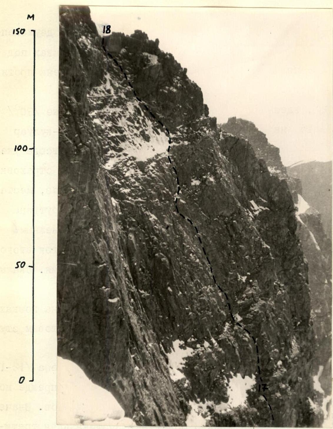
 SECOND STEP. Photographed in profile from NE ridge (by Kononov's group).
The upper part of the wall features two transverse cracks where pitons can be driven and ladders hung to reach the inner corner, but the lower part is a completely smooth monolith,
 SECOND STEP. Schematic drawing of the key section.
which we can only pass with the help of an expansion bolt. Further, along the smooth inner corner with a crack where several more pitons and a duralumin wedge are driven, we ascend on ladders to a small protruding rock balcony (R25–R26). This key section of the second step required over three hours of complex work. The procedure of pulling up backpacks was very difficult and exhausting, complicated by the presence of a bend and overhangs.
From the balcony, a nearly sheer slab with a wide crack ascends (R26–R27), along which we move by wedging hands and toes of boots. After the slab, the character of the rocks changes, the wall becomes broken into large boulders, which are comparatively easy to pass despite the significant steepness — up to 85° (R27–R28). Above, the wall overhangs again, and we have to move along a ledge to the right, where there is a crack in the overhanging slab (R28–R29). We manage to squeeze into the crack and climb like through a chimney, but it narrows sharply, and again, we have to drive wedges and hang ladders. Climbing is very difficult, the overhang throws us back, and there are no footholds. Finally, the crack leads to a narrow inclined ledge. From below, we pull up backpacks directly via the overhang (see photo).
Further, after a short sheer wall and a ledge, a not very steep (75°) rock slope begins (R29–R30); along rocks of medium difficulty, we exit onto the shoulder of the second step.
The second step proved to be the most challenging in terms of concentration of extremely difficult sections, tension, and steepness.
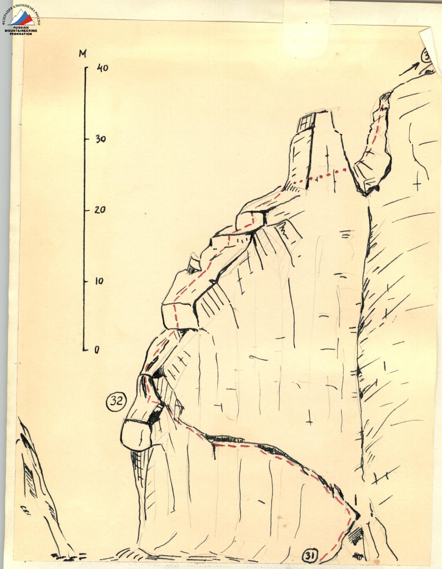 Schematic drawing of the main part of the route.
 It took almost 9 hours of continuous work on the sheer to pass the 120-meter section (R21–R29).
On the shoulder of the step, we managed to lay out an excellent platform and rest well. Here, we also left a control tour.
July 19. Departure at 7:00.
From the shoulder begins the ridge part of the route, leading under the summit tower. The first "needles"-gendarmerie are bypassed on the right along a wide, несложной ledge (R30–R31), which leads to a steep rock gully (R31–R32). Along the gully, we ascend and then move slightly left onto the ridge.
The ridge turned out to be very unique and very complex. It is formed by enormous monolithic blocks overlapping one another like giant tiles. The blocks are bounded by sheer, smooth walls, often overhanging towards us. Movement is slow, individual walls are overcome with the help of ladders on wedges and pitons. Frequent pulling up of backpacks is exhausting. Overcoming this short, seemingly simple from below section (R32–R33) required 5 hours of work.
Finally, the ridge becomes simpler, flattens out, and by 12:00, we reach the base of the summit tower.
The summit tower to the right drops with a smooth 150-meter monolithic NW wall with cornices in the upper part; there's no question of climbing it. After a brief discussion, we also abandon the path along the edge between the NW and NE walls, although its steepness is around 80–85°, and only个别 short sections overhang.
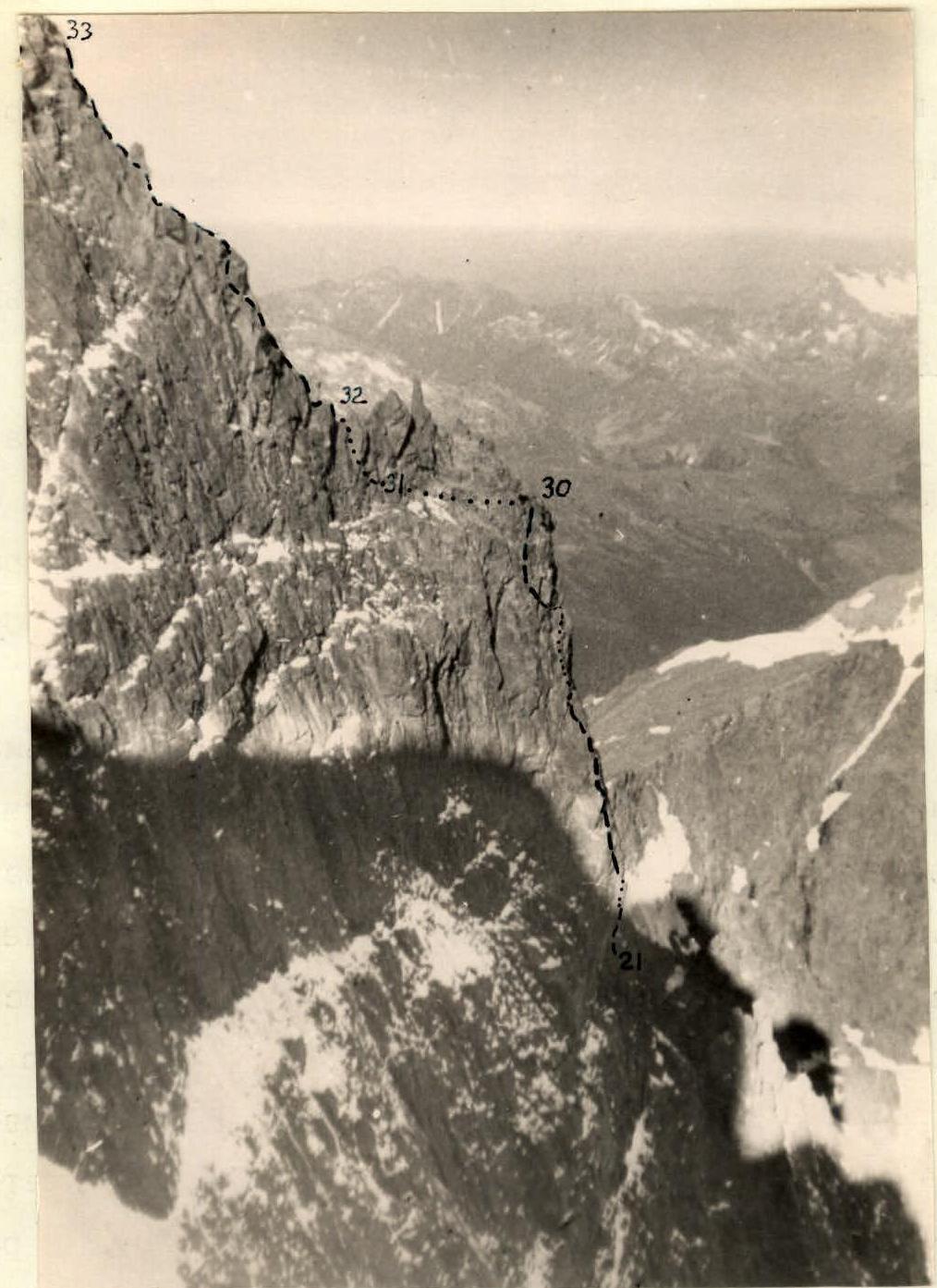 SECOND STEP AND RIDGE. General view. Photographed from NE ridge (by Kononov's group).
Hanging bould