The first ascent to the summit of "Austrian Komsomol" (3600 m) via the Chkhalta-Dzykh pass from the south along the eastern ridge, approximately 4A category of difficulty. Dombay, July 1969, "Krasnaya Zvezda" alpine camp
Photo # 1
Panorama of peaks from the Belalai glacier. From right to left: Kap peak; "German Komsomol" peak; "Austrian Komsomol" peak. (September)
Photo # 2
View from the Belalai glacier to the Chkhalta-Dzykh pass (September).
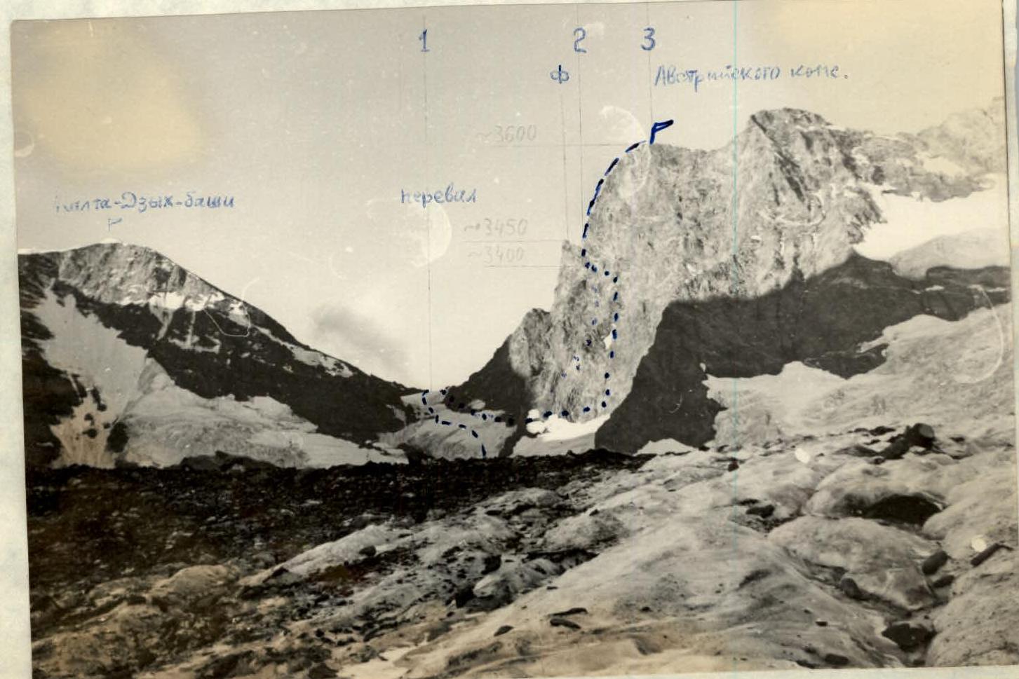
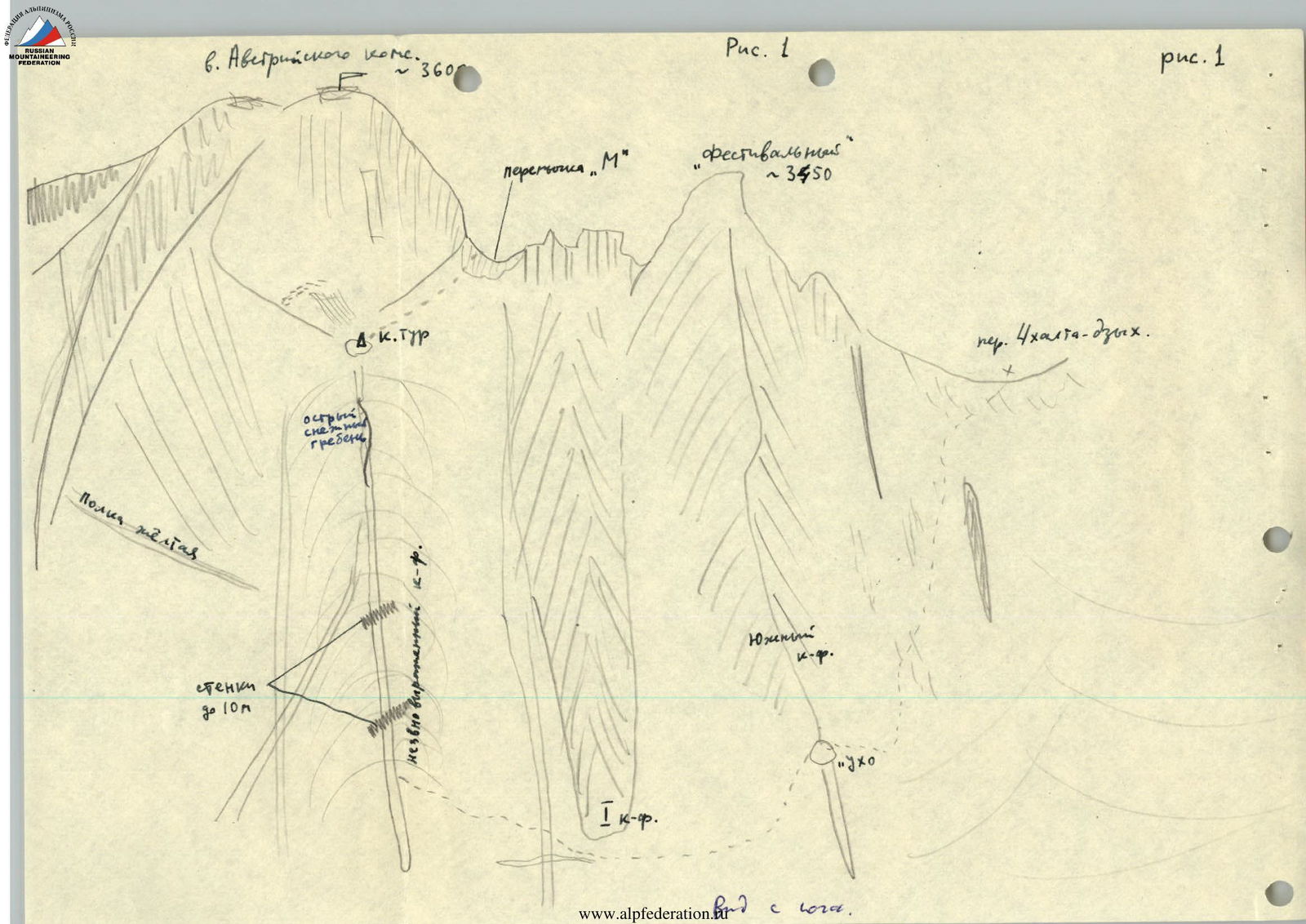
Diagram # 1
of the area of "Austrian Komsomol" peak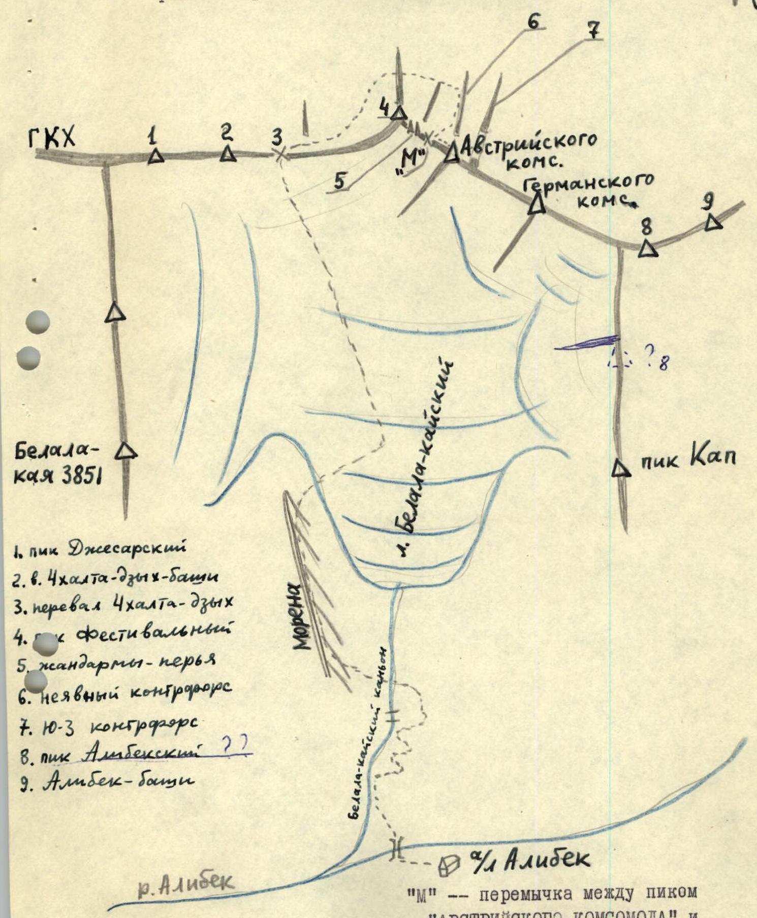 "M" is the saddle between the "Austrian Komsomol" peak and its southeastern summit - Festivalny peak.
In Dombay, opposite the "Alibek" alpine camp, the waterfall and "sheep's foreheads" of the so-called Belalai canyon are clearly visible. Classic routes start from the Belalai glacier: 4A category of difficulty on Belalai-kai via the NW wall; 3A category of difficulty - traverse from the saddle of Kap peak to "German Komsomol" and "Austrian Komsomol" peaks. Often, training groups from Dombay alpine camps make training ascents to Kap peak (1B category of difficulty, not classified).
The described ascent was made from the Chkhalta-Dzykh pass.
I. There is a suspension bridge across the Alibek river, located below the "Alibek" alpine camp. The trail to it starts from the recently built "Shashlychnaya". Further, towards the Belalai canyon, a marked tourist trail goes to the waterfall (from "Alibek" alpine camp - 40 minutes). Then the trail passes along the very overgrown right (in the direction of movement) side of the canyon, bypassing the "sheep's foreheads". Above the forest zone, the path goes through rocks requiring careful navigation. Here, alpinists from "Alibek" alpine camp often conduct training rock climbing sessions. Further, the trail is clearly visible and leads to the bivouac. From under the waterfall - 50 minutes.
From the bivouac, 5 minutes to the left uphill along a faint trail. Here, you need to cross the river to the left side.
River crossing:
- Until approximately July, it is covered with snow, but you need to cross it carefully and attentively, with insurance.
- In late summer, you need to cross via the rock plug at the beginning of the canyon, about 100 meters below the snow bridge, also with insurance.
After crossing the river:
- Climb up to the left along the grassy slope (there is a trail) to the left moraine.
- Move along the moraine ridge and exit onto the Belalai glacier, onto its even flow.
From the bivouac - 55 minutes.
In the upper reaches of the glacier, the Chkhalta-Dzykh pass is visible. It is better to move towards it not along the median moraine, but to cross the glacier to the right and move along the even ice to the end of the moraine.
The ascent route to the pass must be examined from the glacier. The ascent goes approximately like this:
- From the beginning of the ascent, 150 m up, then 150 m to the left up to the bergschrund under a large rock island.
- Having crossed the bergschrund, go around the island from the right.
- Climb straight up the snowy slope with a steepness of 45° to the right of five rock islands - to the pass.
- Total ascent: six 40 m ropes.
It is rational to make the entire ascent to the pass in crampons: the snow is dense, especially after the bergschrund. From the end of the median moraine to the pass - 2 hours. Our group, having left the "Krasnaya Zvezda" alpine camp at 4:15 am, reached the pass at 11:40 am.
 On the same day, the pair Starikov - Egorov from 16:15 to 20:20 conducted a reconnaissance of the starting point of the ascent to the "Austrian Komsomol" peak, bypassing the buttresses of its SE summit - Festivalny peak. An exit was found to a not clearly defined buttress, along which it was planned to ascend to the southern wall of "Austrian Komsomol" peak (after consultation with the participants of V. Kuraksin's group at the camp).
II. July 18, 1969. We left the overnight stay on the Chkhalta-Dzykh pass at 4:15 am. From the pass, in rope teams, to the right down the average scree to a large snowfield. Down along it to the rock gate (Attention! - rockfall from the slopes of the South buttress). Further down to the right, crossing snowy and scree "ties" (fig. 1).
At some point, a round rock window (hole) - "ear" will be clearly visible in the South buttress. Keep direction towards it. Along the snow, having descended a little below the "ear", exit onto rock-grassy ledges and climb up to the "ear" - 100 m. From the pass - 40 minutes. From here, the rock-grassy lower part of the not clearly defined buttress of "Austrian Komsomol" peak is visible.
From the saddle at the "ear", descend down to the snow - 30 m. Along the snow down to the right to the end of buttress-I. In this place, you need to cross up to the left the ice groove and couloir. Attention! - rockfall hazard area. Then, along short firn ascents and simple rocks, exit onto the ridge of the not clearly defined buttress - 100 m. Having climbed up ( местами попеременная страховка ) to the level of the "ear", you will encounter a stream and a good area for a bivouac.
Further, the path goes all the time up along the ridge. There are walls up to 10 m; insurance through ledges. To the left and right - snowy couloirs, along which rocks often rumble. On the upper section of the buttress: snowy ridges, rock islands. The last rock island (loose) - directly under the wall. On it, a control cairn with a note. We were here at 9:30 am.
Further, along the snow to the right up to the saddle "M" along the rocks (on the left) - 3 ropes. When exiting onto the saddle itself, icy rocks are possible - 15 m. From this saddle, the Chkhalta-Dzykh pass is visible below, two "gendarmerie" - feathers to Festivalny peak. From the "M" saddle to "Austrian Komsomol" peak - 6 ropes of 40 m (see fig. 2). The entire ridge is rocky, steep (photo 2), with sections of difficult climbing. There are almost no loose rocks. Insurance is provided by pitons - the first 120 m.
At first, to the left of the ridge along the wall up 20 m, then cross the ridge to the right and move towards the chimney-cleft. Further up along the ridge to the ledge on the right. At the very beginning of the third rope - an overhanging section 3 m. Further up along the ridge, insurance through ledges, alternating movement - to the cairn on the summit. We reached the summit at 1:30 pm. Descended along the ascent route to the Chkhalta-Dzykh pass by 7:30 pm.
III. The ascent from the pass to the summit took more than 9 hours. Nine rock pitons were hammered in. Approximately from 10:00 am, fog rolled in from below, visibility was limited. We descended in the fog to the pass for 6 hours. The route is combined, quite interesting, fully corresponds to the 4A category of difficulty, according to the participants of the ascent (5 people), which was confirmed during the discussion at the camp. Of course, it would be more logical to find an exit to the "M" saddle directly from the pass.
The entire ascent route was photographed, but by an incredible coincidence, the film was lost at the camp during subsequent shifts. July 19, 1969. The descent from the Chkhalta-Dzykh pass along the ascent route to the glacier and further down through the canyon to the "Krasnaya Zvezda" alpine camp took 4 hours 30 minutes.
Description compiled by: G. Starikov
- Starikov G.A. - leader, junior engineer
- Teplov N.E. - trainee
- Strena A.V. - junior engineer
- Petyak N.V.
- Egorov G.B. - trainee