REPORT
on the ascent of Pik Avstriyskogo komsomola from the east, from Chhalta – Dzykh Pass, July 9–10, 1972, first ascent.
I. Group Composition
- Gubanov Yu.D. — CMS, senior instructor KSP Dombay region, unattached, sports society "Burevestnik", Dombay settlement.
- Khamtsov A.P. — 1st sports category, junior instructor alpine camp "Alibek", unattached, sports society "Burevestnik", Dombay settlement.
II. Alpinist and Geographical Characteristics of Pik Avstriyskogo komsomola Region (3650 m)
Pik Avstriyskogo komsomola is located in the Main Ridge and has a long ridge stretching from west to east and dropping steeply to Chhalta – Dzykh Pass (3180 m). At the end of the eastern ridge of the peak, dropping to the pass, there is a shoulder in the form of a huge tooth with a sheer eastern wall. Through this shoulder from the south, along the counterfort, in 1969 a route 4A category of difficulty was passed to Pik Avstriyskogo komsomola. There is also an old route — traverse of Pik Germanskogo komsomola — Pik Avstriyskogo komsomola 3A category of difficulty, which has not been used for a long time. It was passed by a group led by Yu. Gubanov — Yu. Prima in June 1972 to scout other routes in this area, as a result of which the described route was chosen by us. We assumed that it had not been climbed before, as all descents from the traverse of Pik Germanskogo komsomola — Pik Avstriyskogo komsomola 3A category of difficulty and descents from the route on Pik Avstriyskogo komsomola from the south along the counterfort 4A category of difficulty were made to the south, along another, easier counterfort. Apparently, the path from the pass was considered difficult or was completely unknown. Subsequently, when passing the route, before the already passed ridge section, we did not find any traces.
III. Climbing
July 9, 1972 — Day of approach to Chhalta – Dzykh Pass, organization of a bivouac on the pass and reconnaissance of the route. Working hours — 8.
July 10, 1972. Weather is fine.
Day of ascent and return to alpine camp "Alibek". Working hours — 15. Weather is fine.
The climbing tactics provided for the organization of a full-fledged bivouac on the pass and further passage of the route lightly, without a bivouac, after a thorough reconnaissance made the day before. The safety of the group was ensured by radio communication with the alpine camp "Alibek" using a "Vitalka" radio station (with flares as a backup) and observation from the camp.
IV. Route Description
The path to Chhalta – Dzykh Pass is described in detail in the book by F. Kropf "Western Caucasus". On the pass, there are excellent bivouac sites at any time of the year and in any weather. Water is always available nearby. From Chhalta – Dzykh Pass to the right — up to the west along the scree on the southern side of the ridge — to the saddle under the ascent. From the saddle:
- 30 m straight up (hook),
- then 40 m to the right along a gentle, smooth ledge,
- and 20 m to the right — up along a steep, then very narrow ledge above the sheer drop (hook protection), bypassing the vertical part of the ascent beyond the bend.
From the bend:
- 30 m to the right along a smooth, wet, inclined ledge (hook protection),
- and exit to the lateral part of a wide, steep couloir.
From the couloir:
- 30 m to the left — up along a destroyed inner corner,
- and another 30–40 m along steep and smooth, grassy, inclined slabs (hook protection),
- to a scree-covered area (possible bivouac site).
From the area:
- 30 m to the right — up along steep slabs with cracks (hooks),
- then another 40–50 m to the right along ledges,
- and exit to a saddle on the summit ridge (possible bivouac site).
From the pass — 5–6 hours.
Further along the rocky ridge with numerous ascents, sometimes along the ridge, but not moving away from it. Small walls on the ridge are passed with hook protection. From the saddle to Pik Avstriyskogo komsomola — 2–3 hours. On the summit — a possible bivouac site.
To descend to the south, it is necessary to:
- first walk 20–30 minutes to the west along the summit ridge, to its next gentle ascent,
- from which turn left (in the direction of travel), to the south,
- and descend along a not very steep, very destroyed counterfort, grassy in its lower part.
From the lower part of the counterfort, you need to go left — down to the firn fields of the southern glacier. From the summit — 2–3 hours.
Along the firn fields — traverse under the southern walls of Pik Avstriyskogo komsomola to the east, and further, bypassing the walls and counterforts up to Chhalta-Dzykh Pass. Another 2–3 hours.
If descending from the summit along the ascent route, you need to have hooks and loops for three to four rappels of 30 m.
V. Recommendations for Climbers
- Number of participants in the group — 4–6 people.
- Best time for climbing: July–August.
- Initial bivouac — Chhalta-Dzykh Pass.
- Departure time from the bivouac — 5:00.
- Special equipment for a group of 4 people:
- Main rope 2 × 30–40 m
- Rock hooks — 10–15 pcs.
- Carabiners — 10 pcs.
- Hammers — 2 pcs.
In the second half of summer, crampons and ice hooks are needed to reach Chhalta-Dzykh Pass.
VI. Route Characteristics (by sections)
SECTION No.1 (Destroyed ridge to the "tooth") — rocky, scree, simple. Length 350–400 m. Average steepness 40°. The whole section is passed simultaneously, no hooks were used.
SECTION No.2 (Northeastern wall of the "tooth") — rocky, medium complexity. Length 250–300 m, average steepness 65–70°. The rocks are generally solid, smooth. Micro-relief is developed (corners, ledges). There are not many cracks. There are enough places for protection. Almost the entire section — alternate movement. 10–12 rock hooks were used. A bivouac is possible in one place.
Note: with heavy snow cover, the section is much more difficult to pass (smooth ledges and slabs).
SECTION No.3 (ridge from the "tooth"), rocky, medium complexity. Length 400–500 m. Average steepness 50–60°. The ridge is steep, in places sharp, somewhat destroyed, but overall quite solid. The relief is rich, movement is possible almost everywhere simultaneously. Protection — through ledges and hooks. There are no convenient places for a bivouac.
Overall, the route is very logical (from the pass — to the summit), safe from rockfall from the side, and valuable for training purposes. Located not far from the camp (5–6 hours to the pass). According to the group members, the category of difficulty of the route corresponds to 4A.
Appendices to the report
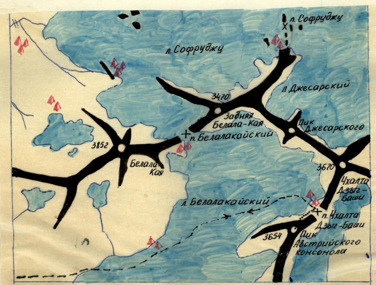
- Map of the Belalakay glacier cirque area.
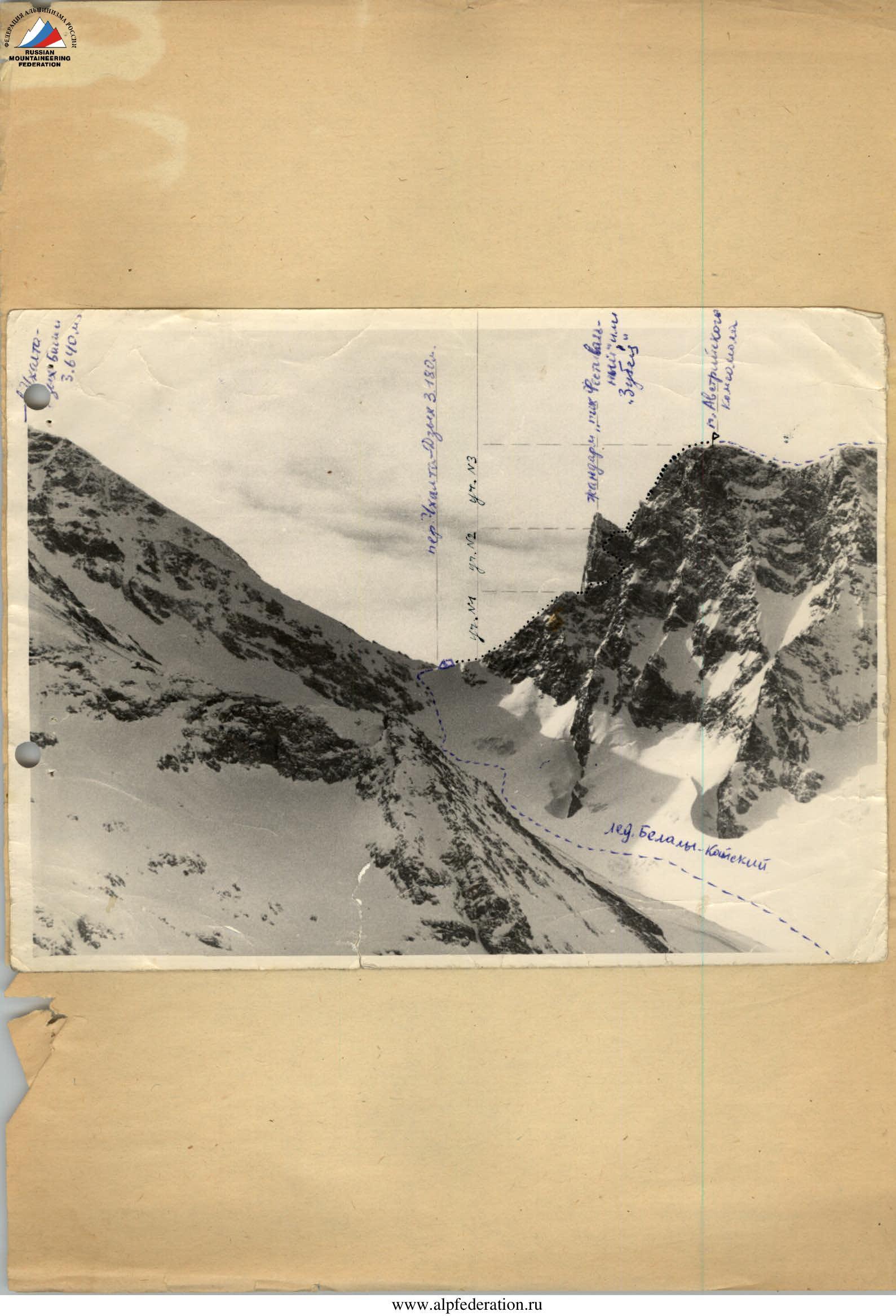
- Photograph of the route (the approach path is marked with dashes, the route is marked with a dotted line, the group's bivouacs are marked with triangles, and control tour locations are marked with landmarks).
Climbers:
- Gubanov Yu.D.
- Khamtsov A.P.