Report on the First Ascent to the summit 3020.0 (Irkis Eastern) via the route "По восточной стене" 3B cat. diff. (rocky) by the team of "Sauk-Pai" club (Syktyvkar) in July 2018
The report was compiled in 2018.
I. Ascent Passport
| № | 1. General Information | |
|---|---|---|
| 1.1 | Leader's full name, sports rank | Nikolayeva Svetlana Olegovna (2nd sports rank, Voronezh) |
| 1.2 | Participants' full names, sports ranks | 1. Besedin Roman (2nd sports rank, Rostov-on-Don) |
| 1.3 | Coach's full name | Zhuravlev Sergey Vasilyevich: CMS, category 1 instructor-methodologist, Syktyvkar |
| 1.4 | Organization | NP "Northern Travels Club 'Sauk-Pai' (Syktyvkar)" |
| 2. Characteristics of the Ascent Object | ||
| 2.1 | Region | Western Caucasus, Arkhyz |
| 2.2 | Valley | Irkis Valley, eastern spur of the Aimanauz-Bashi mountain massif (in KMGV: Academician Kolesnik Peak) - Irkis |
| 2.3 | Section number according to the 2013 classification table | 2.1 |
| 2.4 | Name and height of the summit | Irkis Eastern, 3020.0 (Conditional orographic name, given by the name of the mountain valley. The height of the summit is determined by an altimeter and requires verification by GPS, as it is not marked on the topographic maps of the Russian Federation) |
| 2.5 | Geographic coordinates of the summit (latitude/longitude), GPS coordinates | Geographic coordinates: latitude - 43°04′05″; longitude - 41°07′30″. GPS coordinates: |
| 3. Route Characteristics | ||
| 3.1 | Route name | По восточной стене (Along the eastern wall) |
| 3.2 | Proposed category of difficulty | 3B (rocky) |
| 3.3 | Degree of route exploration | First ascent |
| 3.4 | Relief characteristics of the route | Rocky |
| 3.5 | Height difference of the route (altimeter or GPS data) | From the base camp in the upper reaches of the Aimanauz River (height - 1900 m) to the summit (3020.0) - 1120 m. Height difference of the technical part (from R0, 2300 m) to the summit (3020.0) - 720 m |
| 3.6 | Route length (in meters) | 925 m |
| 3.7 | Technical elements of the route | I cat. combination - 400 m (on approach, not included in the description). II cat. rocks - 1 section - 100 m. III cat. rocks - 4 sections - 760 m. IV cat. rocks - 1 section - 55 m. V cat. rocks - 1 section - 10 m. Movement on a closed glacier - none. Rappelling - on descent - 2 × 50 m = 100 m |
| 3.8 | Descent from the summit | To the northwest, first two rappels, then along talus and snow slopes |
| 3.9 | Additional route characteristics | 1. In summer, there is no water on the route. 2. It is convenient to use friends, stoppers of medium and large sizes along the route. 3. In the central part of the wall, there are wide ledges for setting up a tent in case of an overnight stay |
4. Characteristics of the Team's Actions
| 4.1 | Travel time | 13 hours |
|---|---|---|
| 4.2 | Overnight stays | none |
| 4.3 | Route entry time | 6:00, August 21, 2018 |
| 4.4 | Summit time | 16:00, August 21, 2018 |
| 4.5 | Return to base camp time | 19:00, August 21, 2018 |
| 5. Report responsible | ||
| 5.1 | Full name, e-mail | Zhuravlev Sergey Vasilyevich, mr.Zhur1958@mail.ru |
II. Ascent Description
1. Characteristics of the Ascent Object
1.1. General photo of the summit
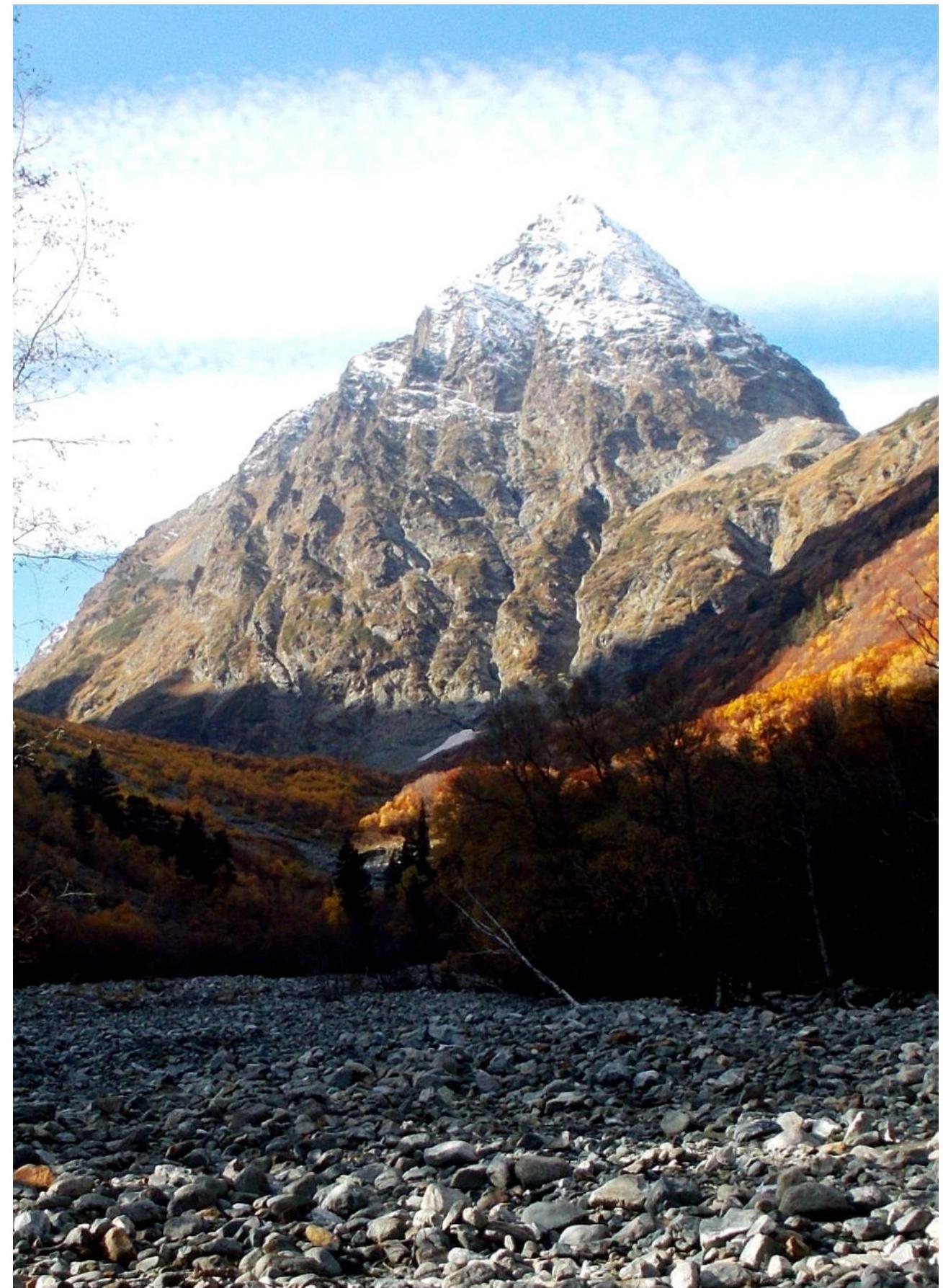
Photo of the summit 3020.0 (Irkis Eastern) from the northeast, from the Aimanauz valley, July 2018.
1.2. Photo of the route profile
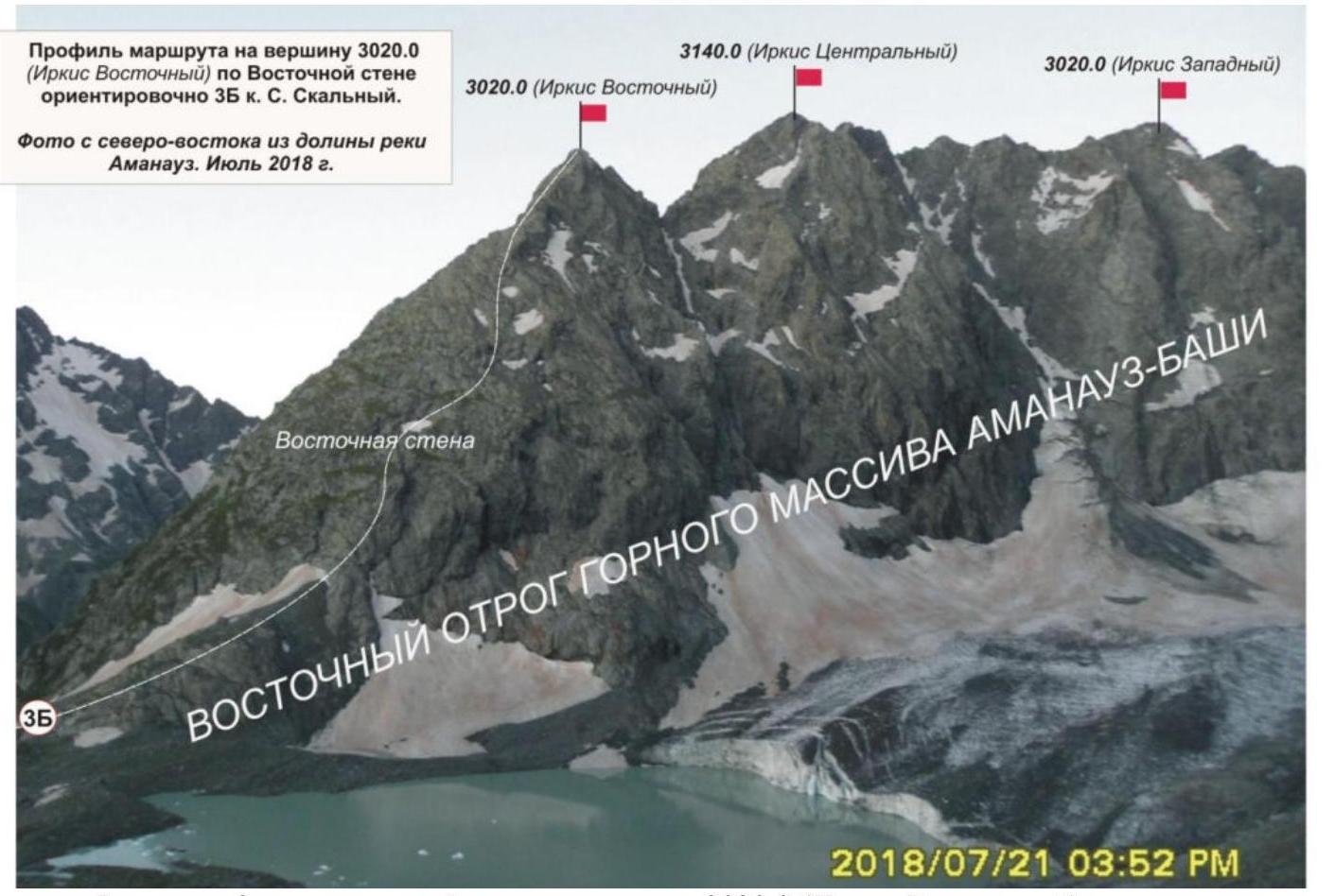
Photo of the eastern wall profile of the summit 3020.0 (Irkis Eastern) from the northeast, from the western slopes of Dorbun-Kaya mountain. The line of the passed route is marked on the profile.
1.3. Photopanorama of the region

Overview photo of the region: eastern spur of the Aimanauz-Bashi mountain massif. Photo taken from the northeast from the Aimanauz valley. July 2018.
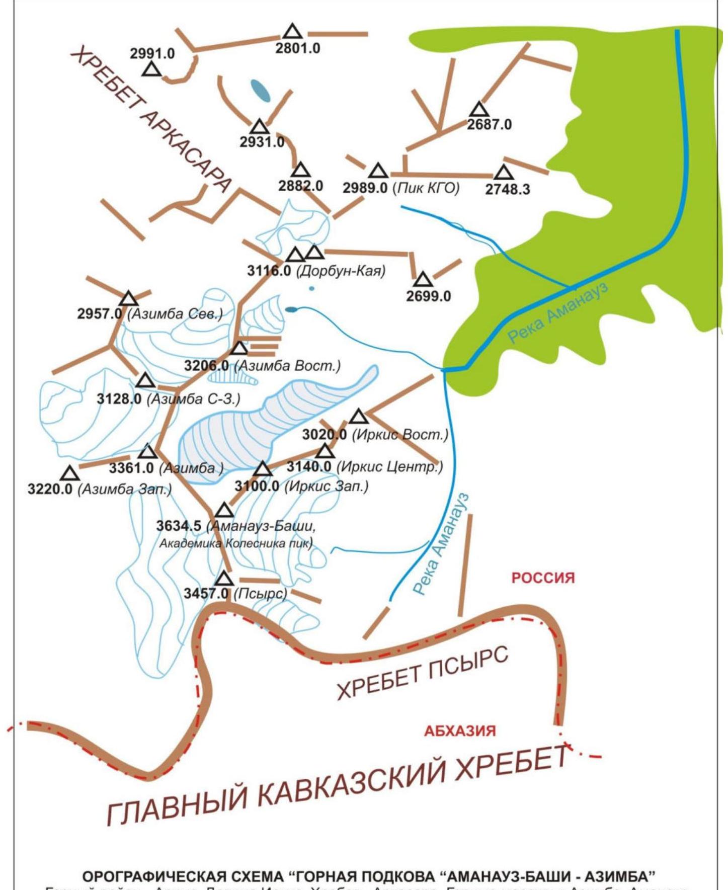
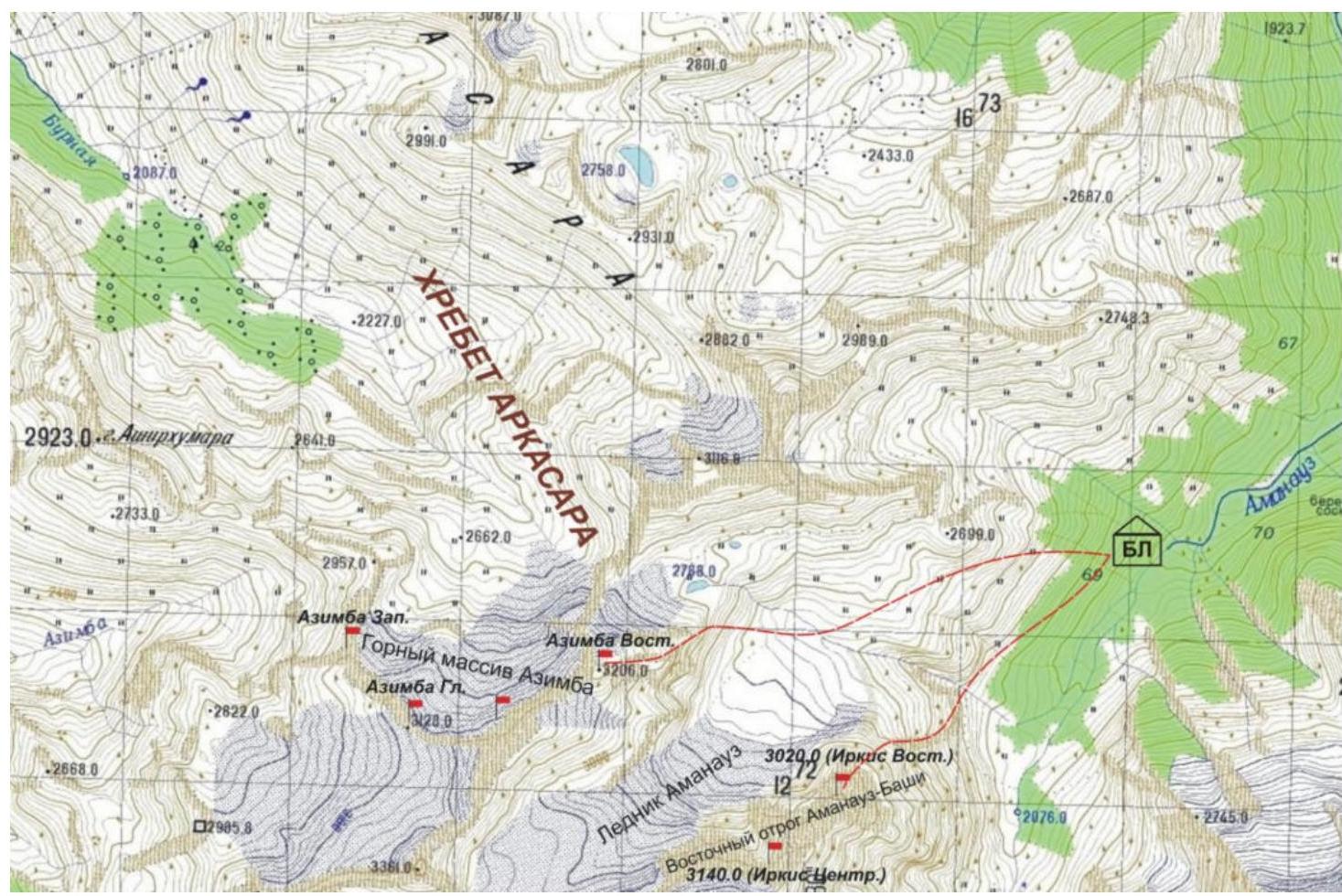
1.4. Map of the region
Orographic scheme of the region. Made from an enlarged fragment of the General Staff map of the Russian Federation, executed on a scale of 1 cm - 500 m. Southwestern part of the Arkassara ridge. Mountain horseshoe "Aimanauz-Bashi - Azimba" in the upper reaches of the Aimanauz River.
Brief geographical overview of the ascent region. Logistics in the ascent region.
The Irkis Valley is part of the mountainous Arkhyz region (Western Caucasus), located 15 km southwest of the Arkhyz settlement, in the Zelenchuksky district of the Karachay-Cherkess Republic. The name of the valley is official and marked on the topographic maps of the Russian Federation. The valley (gorge) is formed by the ridges:
- In the upper reaches of the Pshish River - the Main Caucasian Range with the nodal mountain Pshish
- The right bank of the Pshish River and the Irkis Valley - the Sofiysky ridge, which closes the Orlenok spur with the nodal mountain - 3031 (Orlenok)
- The left bank of the Pshish River and the Irkis Valley - the Arkassara ridge and its northeastern spur Gabulu-Chat with the nodal mountain of the spur - Скала Горячева (Rock Goryacheva)
To the base camp in the Irkis valley near the mouth of the Ayulyu (Belaya) river or to the sites in the upper reaches of the Aimanauz River, it is easy to get by high-passability vehicles from the Arkhyz settlement (3-4 hours), from the Taulu glade (1.5-2 hours). There is no cellular phone connection from the Irkis valley.
The Arkassara ridge is a peripheral mountain range of the Western Caucasus, adjacent to the Main Caucasian Range in the northwest of the GKKh section - the Psyrts ridge, in the area of the summit 3457.0 (Psyrts). The ridge first departs to the north, then changes direction to the northwest. The Arkassara ridge is a watershed for the mountain valleys of the rivers:
- Bolshaya Laba and its tributaries - Azimba, Buraya (in the northwest)
- Bolshaya Dukkka, Malaya Dukkka (in the northeast)
- Pshysh and its tributaries - Aimanauz, Ayulyu (Belaya) (in the east)
Bolshaya Dukkka, Pshysh are tributaries of the Arkhyz River. The Arkassara ridge has several pronounced spurs and mountain massifs.
- The Aimanauz-Bashi mountain massif is located in the watershed ridge in the upper reaches of the Bolshaya Laba and Aimanauz rivers. The highest peak of the Arkassara ridge is 3534.5 (Aimanauz-Bashi). The name of the mountain is not indicated on the map and in the register of geographical names of the Karachay-Cherkess Republic, but is used in land management documents of the Zelenchuksky district administration of the Karachay-Cherkess Republic, indicating a traditional name for this mountain and mountain massif. The mountaineering name existing in KMGV - Academician Kolesnik Peak - is conditional and accepted only among Stavropol mountaineers.
- The Azimba mountain massif is located in the watershed ridge in the upper reaches of the Azimba and Aimanauz rivers - northwest of the Aimanauz-Bashi mountain massif. In the central part of the massif, there are five peaks, four of which exceed three thousand meters.
- The Gabulu-Chat ridge is a peripheral ridge adjacent to the Arkassara ridge at the peak 3213.7 (Bolshaya Dukkka-Bashi). The ridge departs from the Arkassara ridge to the northeast and is a watershed for the Bolshaya Dukkka and Pshysh rivers.
- The Bolshaya Dukkka-Bashi mountain massif is located in the central part of the Arkassara ridge and serves as a watershed for the Bolshaya Laba (northwest), Bolshaya Dukkka (southeast) rivers.
- The Zakzan-Syrt mountain massif is located in the northwest of the Arkassara ridge and serves as a watershed for the Bolshaya Laba (northwest) and Bolshaya Dukkka (southeast) rivers.
Enlarged fragment of the map, executed on a scale of 1 cm - 500 m, with the marked line of approaches and routes of the first ascents made in July 2018.
Mountain massif and summit - object of the first ascent
The eastern spur of the Aimanauz-Bashi mountain (Irkis) is a pronounced mountain-landscape formation, departing from the main peak of the Aimanauz-Bashi massif. The spur is short, rocky, and consists of three pronounced peaks above 3000 m.
The summit 3020.0 (Irkis Eastern) is a rocky peak, completing the eastern spur (Irkis). It is located between the streams forming the Aimanauz River. The summit is a peripheral peak of the eastern spur.
The name of the summit 3020.0 - Irkis Eastern - is unofficial, given for identification by the name of the valley where it is located.
The route to the summit 3020.0 (Irkis Eastern) "Along the eastern wall" is a typical educational and sports rocky route of 3B category of difficulty, with a diverse set of natural obstacles corresponding to the complexity of mountaineering routes of this level.
2. Route Characteristics
3.1. Technical photograph
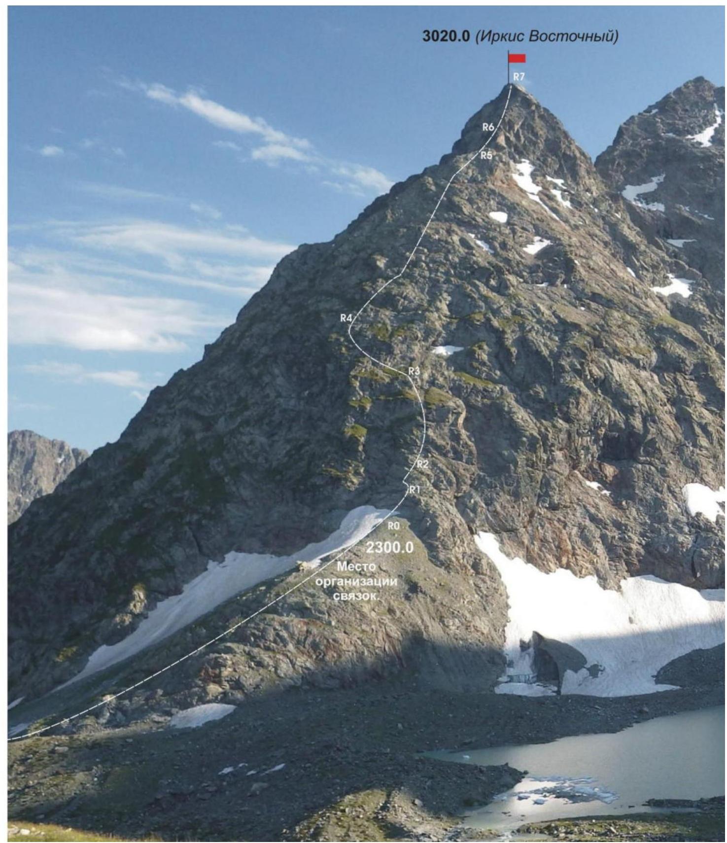
Photo of the route from the Aimanauz valley. July 2018. The line of ascent and reference points of technical sections of the route are marked.
3.2. Technical characteristics of the route sections
Scheme in UIAA symbols

Table of technical sections of the route.
| Section № | Relief characteristics | Cat. diff. | Length, m | Type and number of hooks |
|---|---|---|---|---|
| R0 | Rocky-talus shoulder. Place of organization of links, start of the technical part of the route. Height mark - 2300 m above sea level. | |||
| R0–R1 | Slabs with grass in cracks and fractures, steepness 30–40° | 2 | 100 m | 0 |
| R1–R2 | Dense smoothed slabs, steepness 40–50° | 3 Convenient station | 70 m | 4 закладки (4 cams) |
| R2–R3 | Stepped wall, steepness 75° | 4 Convenient stations | 55 m | 5 закладки, 3 френда (5 cams, 3 friends) |
| R3–R4 | Weakly expressed ridge of inclined smoothed slabs with oblique and horizontal flat ledges | 3 Convenient stations on ledges | 320 m | 16 закладки, стопперы, френды (16 cams, stoppers, friends) |
| R4–R5 | Descent to a round snowpatch and ascent along a couloir to a steep ridge of monolithic rocky blocks | 3 Convenient station | 120 m | Rappelling. A rappel loop is left on a ledge. |
| R5–R6 | Keystone wall "Треугольник" (Triangle) | 5 Convenient station | 10 m | 2 френда, 2 кр. (швеллер) (2 friends, 2 crampons (channel)) |
| R6–R7 | Rocky ridge leading to the summit dome | 3, 2+ Convenient station | 250 m | 0 |
| R7 | Summit 3020.0 (Irkis Eastern) | Convenient site | 0 | 0 |
3. Characteristics of the team's actions
3.1. Brief description of the route passage.
| Section № | Description | Photo № |
|---|---|---|
| APPROACH | From the base camp on the left bank of the Aimanauz River, ascend along talus and simple destroyed rocks to the rocky shoulder to the base of the eastern wall (height mark - 2300 m). | |
| R0 | Rocky-talus shoulder under the eastern wall. Place of organization of links. Convenient place for a short rest, snack, and equipment preparation. | |
| R0–R1 | Ascent along slabs, crossing an oblique snow ledge, and ascent along slabs with grass in cracks under the stepped wall. Length - 100 m. Steepness - 40–50°. Difficulty level - 2 cat. diff. with separate sections of 3 cat. diff. Simultaneous movement on a shortened rope, using relief. | Photo №1 |
| R1–R2 | Ascent along steep smoothed slabs under the stepped wall. Length 70 meters. Steepness 55–60°. Difficulty level - 3, 3+ cat. diff. Movement with alternate belay. | |
| R2–R3 | Stepped wall. On the left, a well-expressed landmark - карниз «Чёрный Угол» (Black Corner). On the right - a long cornice. Steepness of the steps - 75°. Length - 55 meters. Difficulty level - 4 cat. diff. In the upper part of the wall - smoothed slabs - «катушки» (drums). Movement with alternate belay. | Photo №2 |
| R3–R4 | Passage of a weakly expressed ridge of inclined smoothed slabs, intersected by inclined flat ledges. There are separate short walls of increased difficulty of 5–10 meters. Search for relief for закладные детали (camming devices) is not a problem. Movement with alternate belay using ledges, loops thrown over ledges. Steepness of the section - 45–50°. Length of the section - 320 meters. Difficulty level - 3 cat. diff. with elements of 4 cat. diff. | Photo №3 |
| R4–R5 | Bypass of a sharp ridge section along a round snowpatch and couloir with exit to a ridge under the key wall "Треугольник" (Triangle). Steepness of the section - 35–40°. Length of the section - 120 meters. Difficulty level - 2+ cat. diff. - 3 cat. diff. Simultaneous movement. | |
| R5–R6 KEY! | Passage of the triangular wall. Steepness of the section - 90°. Length - 10 meters. Difficulty level - 5 cat. diff. Movement with alternate belay. | Photo №4 |
| R6–R7 | Passage of the pre-summit ridge and exit to the summit. Dense large-block rocks. Sharp ridge. In the upper part, before exiting to the summit, it becomes more gentle, turning into inclined slabs. Subjective rockfall hazard when transitioning from the ridge to the slabs. Length - 250 m. Steepness - initially 55–60°, in the upper part - 40–30°. Difficulty level - initially 3+ cat. diff., in the upper part - 2 cat. diff. Movement with alternate belay. | Photo №5, 6, 7 |
| R7 | Summit - rocky-talus dome. A tour is set in the central part by the first ascenders of the route. | |
| DESCENT | Descent from the summit to the northwest from the saddle between the summits 3020.0 (Irkis Eastern) and 3140 (Irkis Central). Requires organization of two rappels of 50 m each. Further, it is technically not difficult, along talus slopes and snowpatch into the Aimanauz River valley. |
1.2. Photo of the team on the summit at the control tour.
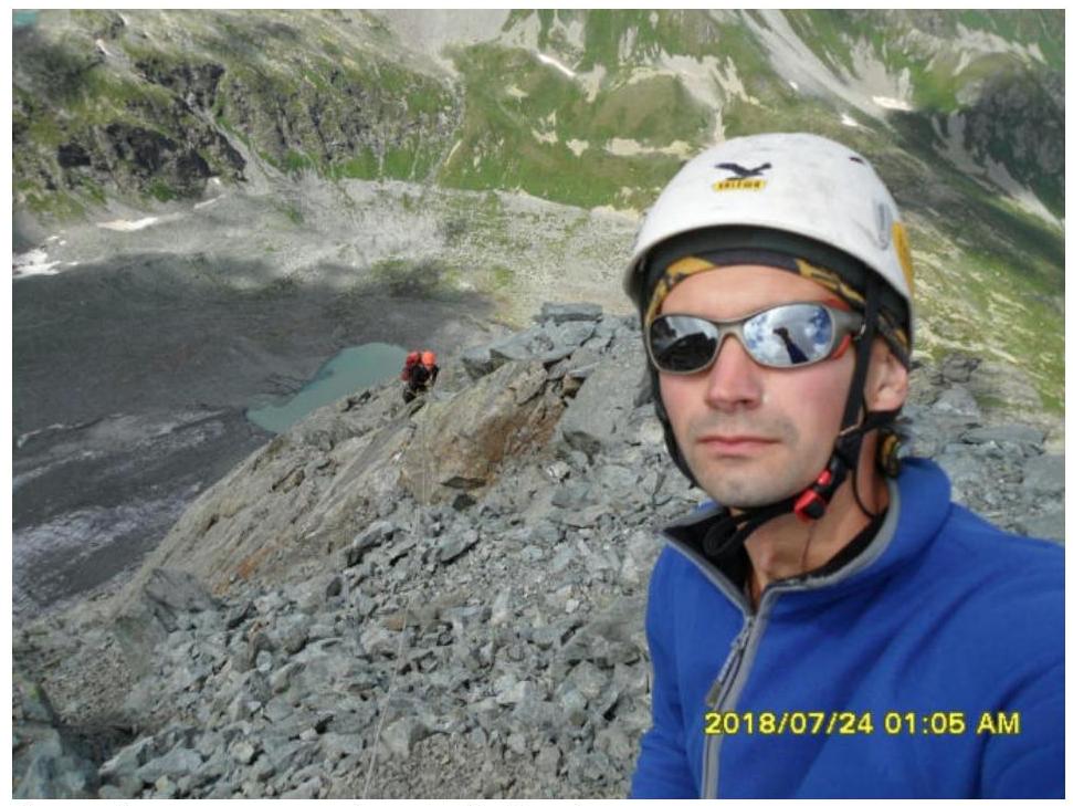
Ascent leader - R. Besedin - on the summit, ascent participant - S. Nikolayeva - is passing the last rope before exiting to the summit. There was no control tour on the summit; it was set by the first ascenders of the route.
1.3. Assessment of the route's safety.
The route to the summit 3020.0 (Irkis Eastern) "Along the eastern wall" is a typical wall educational and sports route of 3B category of difficulty, allowing to test not only the technical knowledge, skills, and abilities of mountaineers of the 3rd sports rank and above but also their level of tactical preparedness.
Accessible approaches and ease of orientation when searching for the route are one of the safety qualities.
Communication on the route was carried out using VHF radios - the route is in direct line of sight from the Irkis valley, from the base camp. Mobile phone communication with the Arkhyz settlement and emergency services is possible throughout the technical section and from the summit.
The route is wall-type, along a weakly expressed ridge, along dense rocky slabs and wall sections. There are convenient ledges and sites for organizing stations throughout the route. The relief allows the use of various camming devices for organizing intermediate belay points and self-belay. The route meets the safety requirements of mountaineering educational and sports routes.
Analogues of the route: MNR (Prielbrusye, Kurmychi valley), Khitsan (North Ossetia, Tsey) - 3B cat. diff., 3200 (Taulan, Dimitrov-100) along the NW edge - 3B cat. diff. (Arkhyz, Orlenok gully).
Photo illustrations
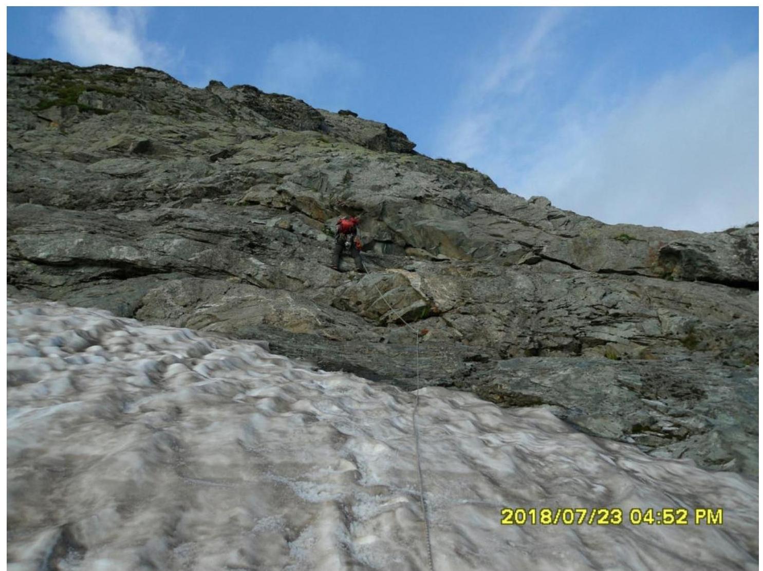
Photo №1: Section R0–R1. Crossing an oblique snow ledge and ascent along slabs. Photo by R. Besedin, July 2018.
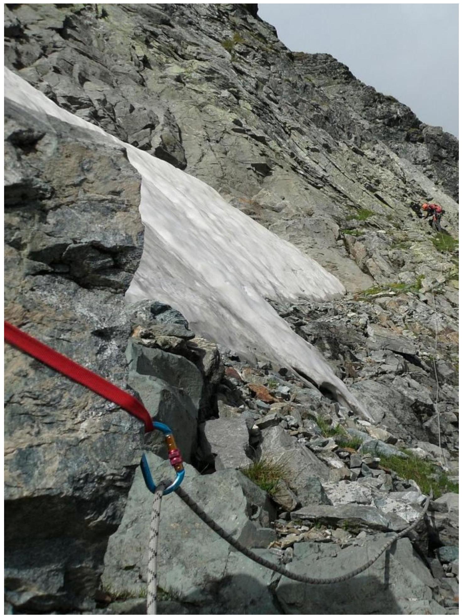
Photo №2: Section R2–R3. Beginning of the passage of the stepped wall. Photo by R. Besedin, July 2018.
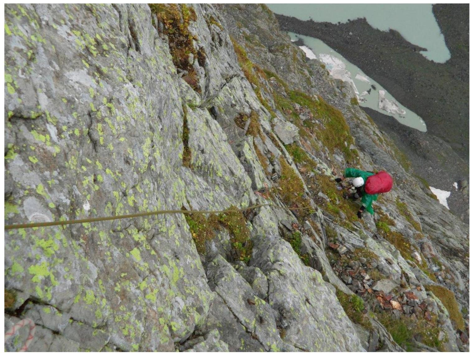
Photo №3: Section R3–R4. Ascent along slabs. Photo by S. Nikolayeva, July 2018.

Photo №4: Section R5–R6. Photo of the key section - rock "Треугольник" (Triangle). Photo by R. Besedin, July 2018.
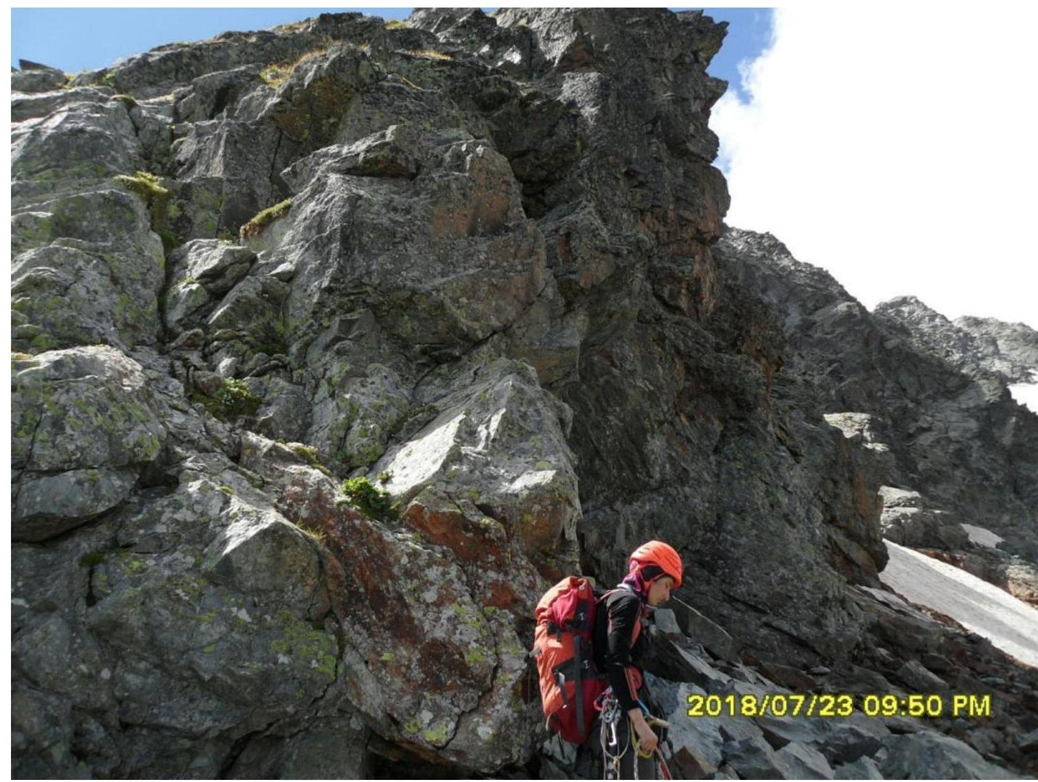
Photo №5: Section R6–R7. Passage of the ridge. Photo by R. Besedin, July 2018.
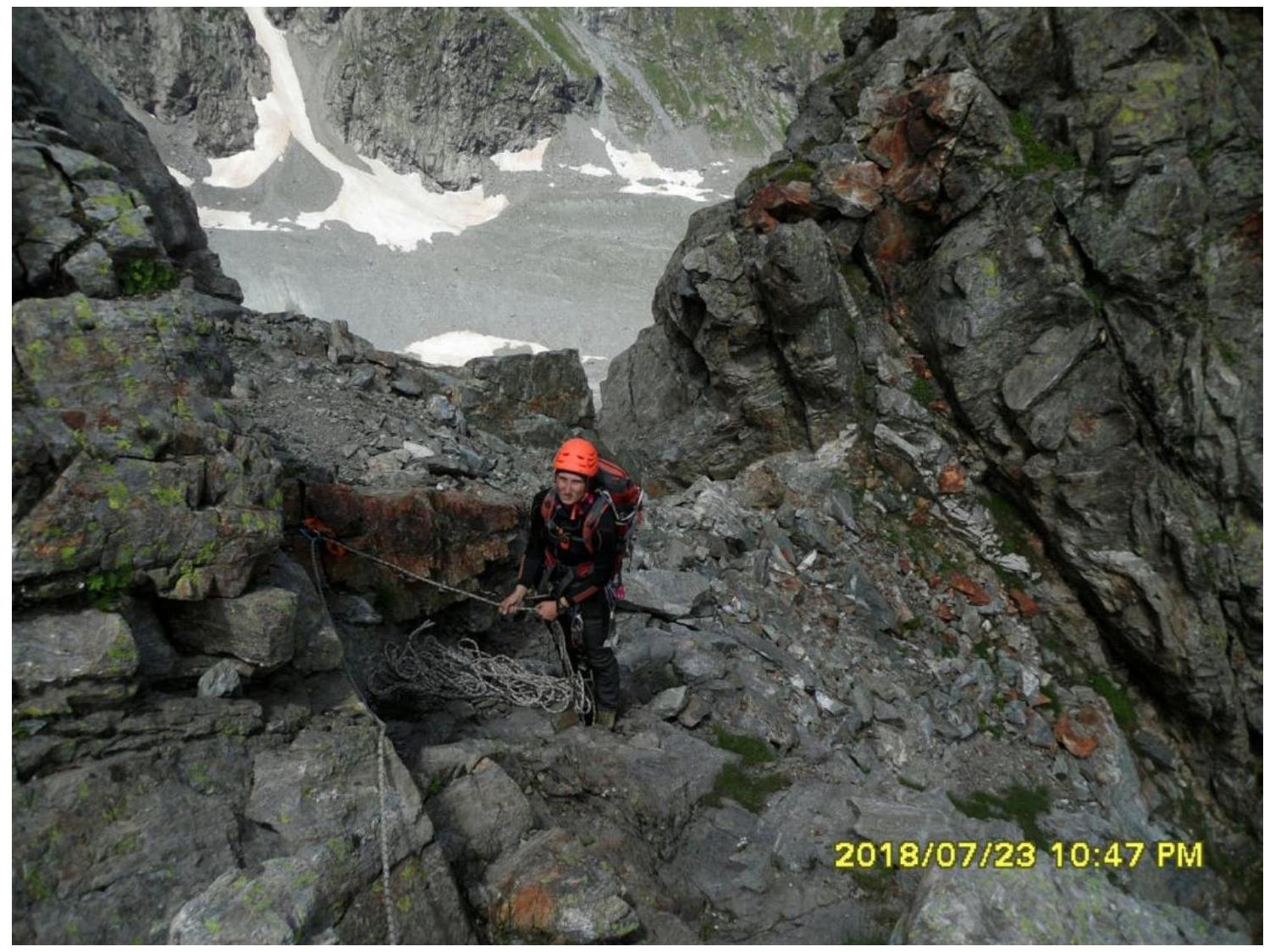
Photo №6: Section R6–R7. Station №8 on the ridge. Photo by R. Besedin, July 2018.
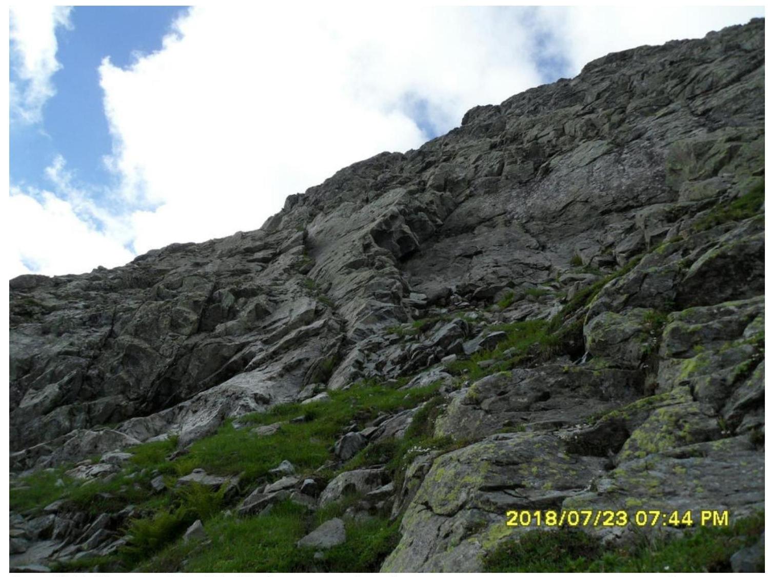
Photo №7: Section R6–R7. Pre-summit ridge, characteristic dense rocks. Photo by R. Besedin, July 2018.
Conclusion
Excerpt from the decision of the coaching council on November 15, 2018, on the results of the analysis of the first ascent of the mountaineering route to the summit 3020.0 (Irkis Eastern). Route: "По восточной стене" 3B cat. diff. (rocky) (approximately), made within the framework of the alpinism competition: "Third stage of the cup of NP 'Northern Travels Club 'Sauk-Pai' - 'Mountains of the World'" (class "First ascents")
An analysis was conducted of the first ascent of the mountaineering route to the summit 3020.0 (Irkis Eastern). Route: "По восточной стене", 3B cat. diff. (rocky) (approximately). The coaching council meeting was attended by:
- Zhuravlev S. V. (Syktyvkar, CMS, category 1 instructor-methodologist) - senior coach-releaser, chief judge of the competition Cup of NP "Northern Travels Club 'Sauk-Pai'";
- Babkin V. V. (Yekaterinburg, CMS, category 2 instructor-methodologist) - OB of the alpinism competition NP "Sauk-Pai", deputy chief judge for safety;
- Maltsev S. L. (Ukhta, 1st sports rank, category 2 instructor-methodologist) - senior judge-expert in the sports discipline of the competition "Class of first ascents";
- Toropov V. A. (Syktyvkar, 1st sports rank, category 3 instructor-methodologist in alpinism).
The route sheet stated an ascent to the summit 3020.0 (Irkis Eastern) of 4A cat. diff. (combined).
The route was completed within the stated timeframe, without TB violations. As a result of the analysis of the ascent, it was determined that sections of 4 cat. diff. are present on the route, but are not decisive for the category of the route according to the methodology for classifying mountaineering routes.
The route corresponds to the technical level of 3B cat. diff. (rocky) and not higher.
Decisions of the coaching council:
- To credit the leadership to the ascent leader of 3B cat. diff., to the participant - participation in the ascent of 3B cat. diff.;
- To recommend the route to the summit 3020.0 (Irkis Eastern) for inclusion in KMGV as a rocky route - 3B cat. diff.
The decision was signed by the members of the coaching council:
- S. V. Zhuravlev,
- V. V. Babkin,
- S. L. Maltsev
Confirmed by the acting director of NP "Northern Travels Club 'Sauk-Pai'" - S. V. Zhuravlev.