REPORT
On the first ascent to the summit of Tsyndyshko North via the North wall, May 5-7, 1972, by a group from the Krasnodar Regional Council of the Burevestnik Sports Society
Group Composition
1. AKHTYRSKY O.A. — CMS — team leader 2. GERASYUK A.K. — CMS — participant 3. BEZRUKAVNIKOV A.I. — 1st sports category — « — 4. SOVENKOV V.S. — 2nd sports category — « —
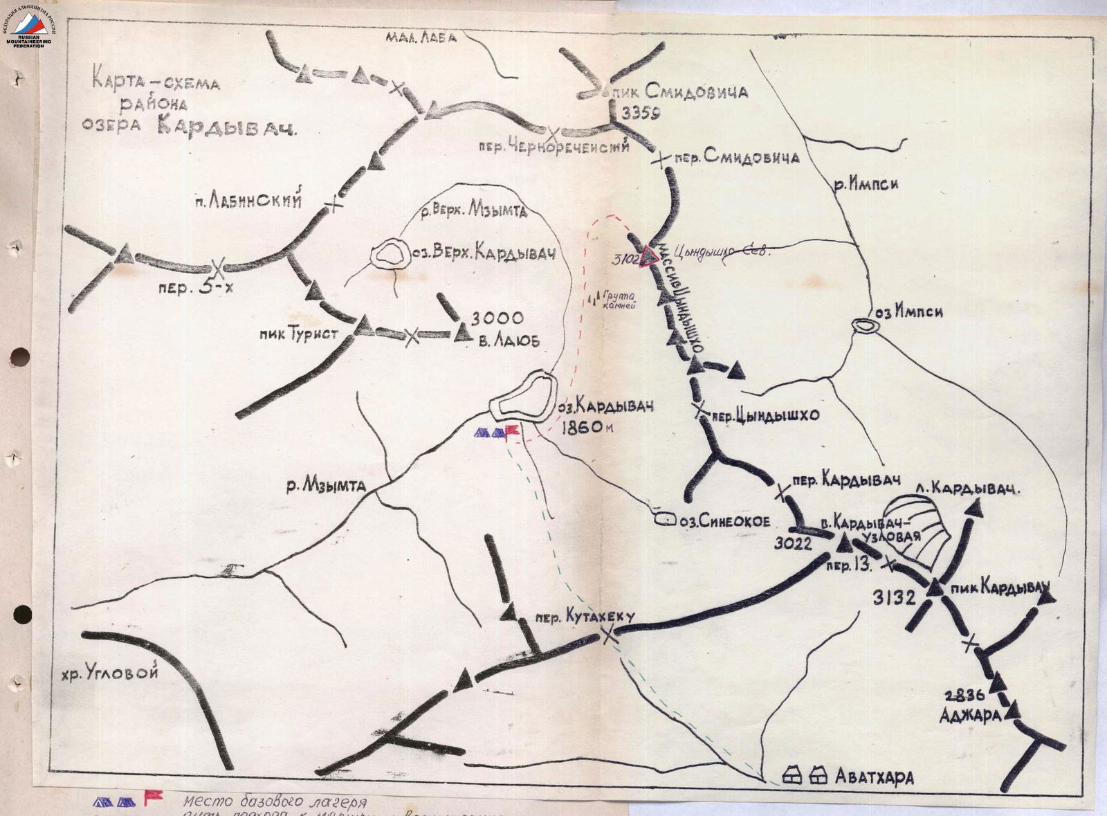
Approach to the Initial Bivouac
From Adler to Lake Ritsa by bus. Then to Avadhara settlement, 4-5 hours on foot or 30 minutes by car (depending on road conditions). Overnight stay. Departure from Avadhara settlement at 4-5 am to reach the southeastern slopes of Kuta-tehu False Pass before sunrise. 1.5-2 hours on foot.
Then:
- Ascend along a pronounced ridge in the direction of travel.
- Snow slopes with a steepness of 25-30°.
- After ascending to the ridge, turn right towards Kuta-tehu Pass.
- Ascend to the pass: 3-4 hours.
- Possible bivouac site.
Then:
- Descend from the pass along a snowy slope with a steepness of 45°. Two ropes.
- Then slope 20°–25°.
- Descend to the forest.
- Upon entering it, turn left and traverse the slope.
- Follow the stream leading to Lake Kardyvach.
- Convenient and safe bivouac site.
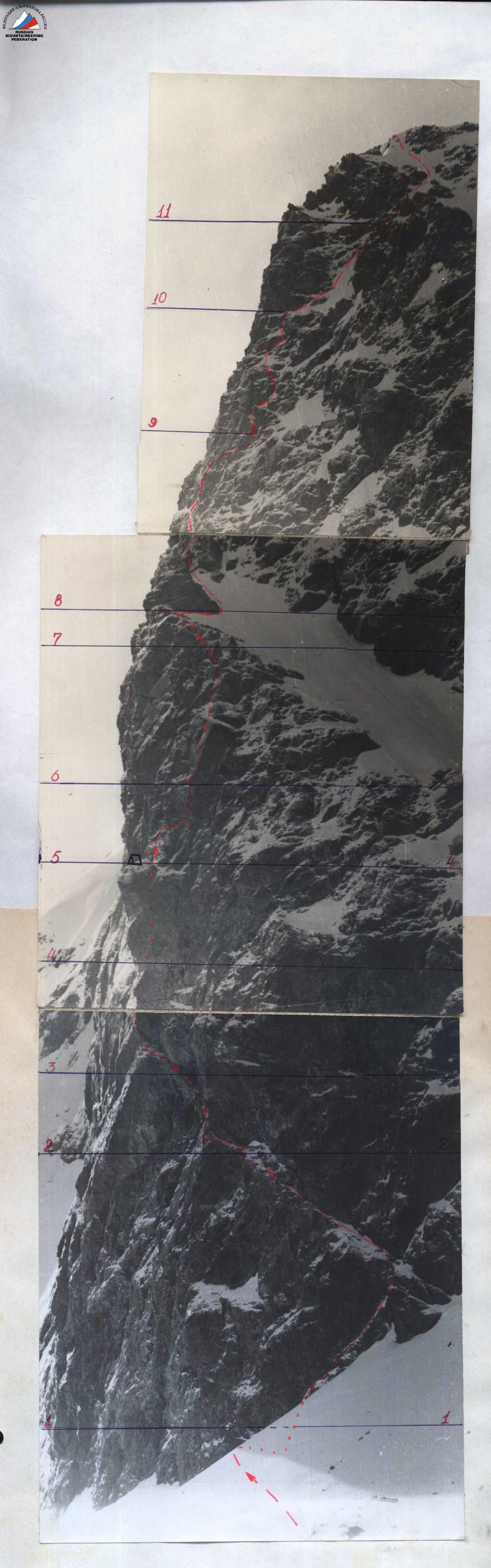
Route Description
First day. May 5, 1972. From the initial bivouac on Lake Kardyvach, ascend along the Upper Mzymta River to a group of large boulders under the slopes of Lashb East peak.
Then, ascend rightwards up a wide snowy slope with rocky outcrops to a "cushion". (From the base camp to the "cushion", 3-3.5 hours).
R0–R1: From the "cushion", 120 m upwards along steep (up to 45°) snow to the base of an inclined ledge crossing the right part of the wall diagonally rightwards. Simultaneous movement.
R1–R2: Along the ledge to a 20 m inclined slab with rime ice. (Two ropes). Pass the slab leftwards upwards and then along a snowy ledge, occasionally interrupted by 3-4-meter walls, to a pronounced expansion — to a snowy terrace. Alternating belay, piton belay. 18 pitons hammered. Distance 140 m. 3.5 hours.
R2–R3: Then, along difficult, icy rocks (15–20 m) to a pronounced external angle with an overlapping structure. Up the angle (5 m) to a convenient exit on its left side and then to an overhanging wall. Alternating belay. 6 pitons hammered. 30 m covered in 1.5 hours.
R3–R4: Under the overhanging wall, traverse along difficult rocks to a large internal angle leading to the "Black Spot" under an overhang. The internal angle is traversed on its right side. Rocks covered with rime ice. Climbing is difficult. 7 rock pitons and 2 ice screws (used as rock pitons) hammered. Distance — 35 m, time — 1.5 hours. Ropes used as a ladder for the group. Key section of the route.
R4–R5: From the "Black Spot" — ascend an 8-meter inclined slab bounded on the right by an overhang:
- leftwards upwards to a flexure
- then upwards along difficult rocks (10–13 m) to monolithic overhanging "feathers"
Under the "feathers":
- traverse left — 2 m
- then straight up through a 2-meter overhang (very difficult climbing)
- exit to a snowy ledge leading to rocks of medium difficulty
37 m covered in 3 hours. 10 pitons hammered. Backpacks pulled up with a rope.
R5–R6: Then, traverse left (4–5 m), then along a wide internal angle to a balcony. Rocks of medium difficulty. However, movement is hindered by loose rocks. 36 m, 1.5 hours. 4 pitons hammered. On the balcony, a convenient spot for an overnight stay. A cairn was built. 280 m of the wall covered for the day. 47 pitons hammered.
Second day. May 6, 1972.
R6–R7: From the balcony, leftwards upwards to a 15-meter crack. Through the crack:
- under an overhanging projection;
- then rightwards onto a wall. Up the wall:
- straight up to a wide ledge with a large projection. Climbing is difficult. 37 m covered in 2 hours. 7 pitons hammered.
R7–R8: From the projection along rocks of medium difficulty 8–10 m to an external angle. Along the crest of the angle to an overhanging part and transition to its left side. Then, leftwards upwards, bypassing the overhang (using pitons), and again onto the crest of the angle. Up the crest along rocks of medium difficulty to a ledge under a 3-meter vertical wall. Along the ledge 4–5 m rightwards, exiting onto block-like rocks. Then, up to the edge of the wall. 90 m covered in 3 hours. 12 pitons + 2 expansion bolts hammered.
R8–R9: Along the edge leftwards upwards along simple rocks under the "Black Gendarme" (70–80 m, simultaneous movement), from which the northern counterfort of Tsyndyshko North begins. 0.5 hours.
R9–R10: Bypass the "Black" Gendarme on the right and then along snow to an internal angle leading to the counterfort. Up the internal angle, then along rocks of medium difficulty to a wide snowy ledge. 150 m covered in 2 hours, 35 pitons hammered. Many ledges available.
R10–R11: From the terrace straight up along difficult rocks (50–60 m). Then along rocks of medium difficulty to a snowy ridge leading under the "Trapeze" Gendarme. 95–100 m covered in 2 hours. 9 pitons hammered.
R11–R12: Bypass the Gendarme on the right under the walls, then along a steep (40–45°) snowy slope to a rocky outcrop. From the outcrop, along snow, exit onto the summit ridge 80 m. 1 hour. Belay via ice axe.
R12–R13: Along the ridge with simultaneous belay to a rocky ascent, where belay is alternating. After the ascent, the ridge becomes more gentle and leads to the summit tower. 250–280 m. 2 hours. Under the tower, a second overnight stay is organized. 750 m covered for the day. 33 pitons hammered.
Third day. May 7, 1972.
R13–R14: From the overnight stay, traverse the base of the summit tower rightwards 7–8 m and along rocks of medium difficulty up a 12–15-meter angle to the summit. Piton belay and belay via ledges. 2 pitons hammered.
Descent from the summit initially along simple rocks of the East Ridge, then along a sharp snowy ridge. 20–30 m before a gap, begin descent leftwards along a steep snowy slope. Then, leaving rocky outcrops on the right, descend into a cirque under the northeastern slopes of Tsyndyshko. From the cirque, without turning left, exit onto a "cushion" and then follow the ascent route back to the base camp. Descent takes 4.5–5 hours.
Route Conclusion
The route via the North wall to the summit of Tsyndyshko North is an interesting combined route. It is logical and safe, rich in challenging sections. The route can be divided into three parts: 1. The wall 2. The counterfort 3. The summit ridge
The most challenging and interesting part is the first section — the wall. Its length is 410 m, with an average steepness of 70°. This section features diverse forms of rock relief, requiring climbers to have high athletic preparedness.
The total route length is 1100 m, with a height difference from the base camp to the summit of 1200 m.
Comparing this route to previously climbed routes, the group believes it surpasses in relief complexity and steepness routes of category 4B, such as:
- Nakra-Tau via the central counterfort,
- Peak MNR central,
- Dombay-Ulgen, western peak.
Based on the above, the group considers the route to be category 4B.
Table of Main Route Characteristics for the Ascent to Tsyndyshko North via the North wall
Route length — 1100 m Including the most challenging sections — 400 m Steepness of the most challenging sections — 75°
 |
|---|
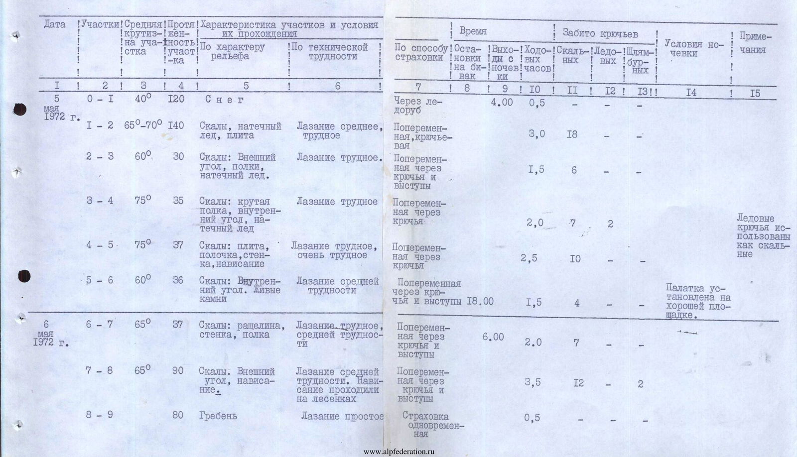
Detailed Table of Route Characteristics
| Date | Sections | Steepness on the section | Length of the section | Characteristics of sections and relief | Technical difficulty | Method of belay | Stops for bivouac | Departure from bivouac | Walking hours | Pitons (rock) | Pitons (ice) | Pitons (expansion) | Bivouac site | Notes |
|---|---|---|---|---|---|---|---|---|---|---|---|---|---|---|
| May 5, 1972 | R0–R1 | 40° | 120 m | Snow | Simple climbing | Through ice axe | 0.5 | |||||||
| R1–R2 | 65°–70° | 140 m | Rocks, rime ice, slab | Medium, difficult climbing | Alternating, piton belay | 3.0 | 18 | |||||||
| R2–R3 | 60° | 30 m | Rocks: external angle, ledges, rime ice | Difficult climbing | Alternating through pitons and ledges | 1.5 | 6 | |||||||
| R3–R4 | 75° | 35 m | Rocks: steep ledge, internal angle, rime ice | Difficult climbing | Alternating through pitons | 2.0 | 7 | 2 | Ice pitons used as rock pitons | |||||
| R4–R5 | 75° | 37 m | Rocks: slab, ledge, wall, overhang | Difficult, very difficult climbing | Alternating through pitons | 2.5 | 10 | |||||||
| R5–R6 | 60° | 36 m | Rocks: internal angle. Loose rocks | Climbing of medium difficulty | Alternating through pitons and ledges | 18:00 | 1.5 | 4 | Tent set up on a good site | |||||
| May 6, 1972 | R6–R7 | 65° | 37 m | Rocks: crack, wall, ledge | Difficult climbing, medium difficulty | Alternating through pitons and ledges | 6:00 | 2.0 | 7 | |||||
| R7–R8 | 65° | 90 m | Rocks: external angle, overhang | Climbing of medium difficulty. Overhang passed on ladders | Alternating through pitons and ledges | 3.5 | 12 | 2 | ||||||
| R8–R9 | 80 m | Ridge | Simple climbing | Simultaneous belay | 0.5 | |||||||||
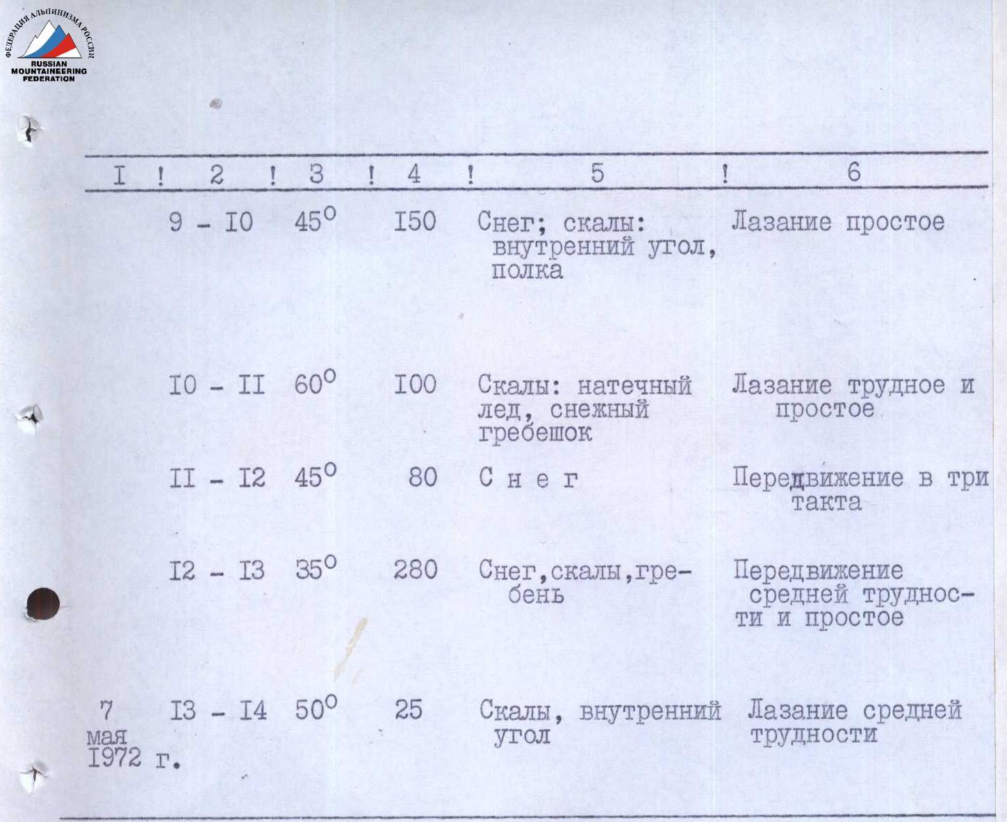
| R9–R10 | 45° | 150 m | Snow; rocks: internal angle, ledge | Simple climbing | Simultaneous and alternating belay through ledges and pitons | 2.5 | 3 | |||||||
| R10–R11 | 60° | 100 m | Rocks: rime ice, snowy ridge | Difficult and simple climbing | Belay through pitons and ledges | 2.0 | 9 | |||||||
| R11–R12 | 45° | 80 m | Snow | Movement in three steps | Belay through ice axe | 1.0 | ||||||||
| R12–R13 | 35° | 280 m | Snow, rocks, ridge | Movement of medium difficulty and simple | Simultaneous belay through ledges | 19:30 | 1.5 | Tent set up on a good site | ||||||
| May 7, 1972 | R13–R14 | 50° | 25 m | Rocks, internal angle | Climbing of medium difficulty | Belay through ledges and pitons | 0.5 | 2 |

View of the route from the west