REPORT on the first ascent to the summit of Tsyndyshho Main via the Western counterfort in the period from April 29 to 30, 1974, by a group from the Krasnodar Regional Council of the Burevestnik Sports Society (Route complexity category — 3B)
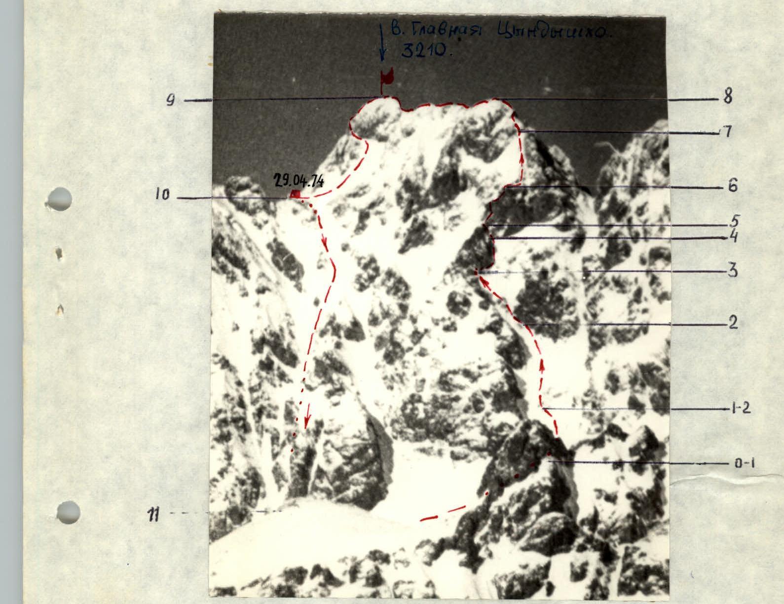
Description of the ascent to Mt. Tsyndyshho Main (3210 m) via the Western counterfort
Group composition:
- Khoruzhik O.V. — 1st sports category — leader
- Shklyaev E.V. — Candidate Master of Sports — participant
- Gerasyuk A.K. — Candidate Master of Sports — participant
- Kovalevsky V.A. — Candidate Master of Sports — participant
- Akhtyrsky O.A. — Candidate Master of Sports — participant
First day — April 29, 1974
Departure from the base camp at Lake Kardyvach — at 4:00, upstream along the right (orographic) bank of the Upper Mzymta River; crossing the Sineokaya River, then right-up along a wide snowy slope towards the saddle between Main and South Tsyndyshho, to the "sheep's foreheads" blocking the couloir mouth (3 hours walking).
R0–R1. From the "sheep's foreheads" at the couloir mouth to the rocky outcrop in the middle part of the couloir — via snow. We bypass the "sheep's foreheads" on the right.
- Section length — 100 m
- Average steepness — 30–35°
- Passage time — 30 min.
R1–R2. Passing the rocky outcrop on the left, we move towards the middle of the base of the "triangular" wall. Belay on the rocks of the outcrop and through an ice axe.
- Section length — 100 m
- Passage time — 1 hour
- 2 pitons driven
- Average steepness of the section — 40–45°
R2–R3. Then left along the wall, we enter a couloir leading to a lowering in the counterfort, before a standalone large gendarme. Under the gendarme — a convenient platform.
- Section length — 50 m
- Steepness of the section — 45°
- Piton belay on the rocks of the "triangular" wall and the left (in the direction of travel) couloir wall
- 3 pitons driven
- Passage time — 40 min.
R3–R4. From the platform under the gendarme, right-up along moderately difficult rocks, we reach a ledge with rimed ice. First along it, and then along steep snow, we bypass the gendarme on the right and along the rocks at the base of the gendarme, partly on snow, we move up towards a narrow chimney (3 m). Through the chimney (difficult climbing) we exit onto a wall under the counterfort ridge. On the wall, there are convenient ledges for belay organization.
- Section length — 110 m
- Piton and feature belay
- 10 pitons driven
- Passage time — 2 hours 30 min.
- Steepness — 55–60°.
R4–R5. From the middle of the wall, we traverse it to the right, towards a destroyed internal corner. Then — difficult climbing up the corner onto the counterfort ridge (15 m) and along the ridge to a monolithic overhang.
- Section length — 35 m
- Belay — piton and feature
- 5 pitons driven
- Steepness — 70°
- Passage time — 1 hour 30 min.
R5–R6. Leaving the overhang on the right, along destroyed rocks, we reach a cleft, ascend through it under a snow-covered 8-meter wall with good handholds. Through the wall, we exit onto the left side of a steep external corner. First on the left side, then transitioning to the right side of the external corner in the upper third (difficult climbing), we ascend to the base of a 40° slab with a small snow-covered ledge. From here, through a 3-meter wall onto a steep inclined shelf and along it onto the counterfort ridge. Along snowy rocks to the start of a steep snowy ridge on the counterfort.
- Section length — 60 m
- Piton belay
- 12 pitons driven
- Passage time — 2 hours
- Steepness — 75°.
R6–R7. Along the snowy ridge, we approach a rocky outcrop. Movement in 3 tempos. Piton and ice axe belay.
- Section length — 60 m
- 3 pitons driven
- Passage time — 1 hour
- Steepness — 45–50°.
R7–R8. We pass the rocky outcrop head-on, towards a narrowing internal corner. The internal corner is partly covered with rimed ice; climbing is moderately complex, sometimes difficult. Up the corner to the left onto a ridge leading to the summit.
- Section length — 30 m
- 3 pitons driven
- Passage time — 1 hour
- Steepness — 60°.
R8–R9. Further movement along a sharp ridge with numerous cornices, sticking to the rocks on the left side of the ridge. Simultaneous belay. 15 meters from the point of exit onto the ridge, a 2-meter descent, then sport climbing to the summit rise. Ascent to the summit via gentle, destroyed rocks — 50 m.
- Section length — 200 m
- Passage time — 1 hour. The summit is a small platform with a sheer face to the east. On the summit, we built a control cairn.
R9–R10. Descent from the summit along the northern ridge towards 2nd North Tsyndyshho — 40 meters sport climbing. Then left along an inclined shelf onto a steep (45–50°) snowy slope — 40 m sport climbing. Along the slope to the right, sticking to the rocks, we exit onto a saddle between 2nd North Tsyndyshho and Main. Descent to the saddle took 1 hour.
- Section length — 160 m
- 3 pitons driven
- Steepness — 50°. Overnight stay on a convenient platform.
Second day — April 30, 1974
R10–R11. From the saddle, descent through the central couloir in the direction of Lake Kardyvach. Started descent at 4:30. Alternate belay through an ice axe. Snow condition is good.
- Section length to the exit from the couloir: 550–600 m
- Passage time: 3 hours 30 min.

Here the descent path is more clearly visible
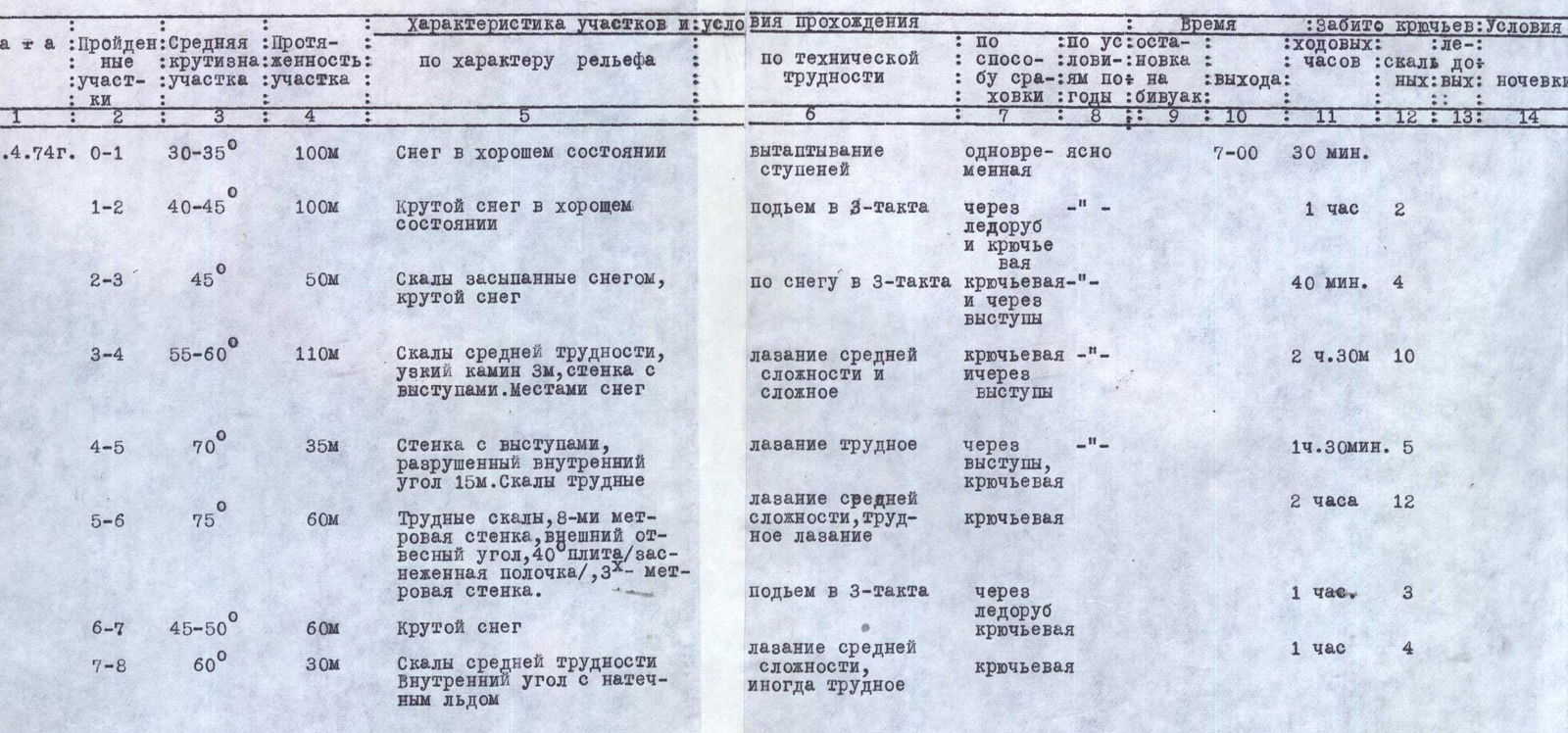
Table of main characteristics of the ascent route to Mt. Tsyndyshho Main via the Western counterfort
- Route length — 745 m
- Including difficult sections — 100 m
- Steepness of difficult sections — 70–75°