
Report
on the ascent of Mt. Fisht Maly (2554 m) via the western ridge, made by the team of the KubSTU "Shturm" climbers' club, Krasnodar first ascent, approximately 3A category of difficulty
Climbing Passport
- Western Caucasus, Krasnodar Krai, 2.1
- Peak Fisht Maly* (2554 m**) via the western ridge
- Proposed - 3A category of difficulty, first ascent
- Route character: rock
- Route elevation gain – 490 m Route length – 1100 m. Length of sections: III category of difficulty – 100 m; IV category of difficulty – 70 m. Average steepness of the route – 30°
- Pitons left on the route: 0.
- Team's climbing hours (to the summit): 6 hours.
- Descent from the summit: to Fishtinsky Pass and further from the pass to the west
- Leader: Ivashchenko Mikhail Nikolaevich, CMS
Participants:
- Skvortsov Nikolai Nikolaevich, 2nd sports category
- Sharov Mikhail Valerievich, 2nd sports category
- Coach: Shaulsky Dmitry Sergeevich, CMS
- Departure to the route: 6:00, May 10, 2014 Summit arrival: 12:00, May 10, 2014. Return to the base camp: 14:00, May 10, 2014.
- Organizations: RSO "Federation of Alpinism of Krasnodar Krai" KubSTU climbers' club "Shturm", Krasnodar
- Responsible for the report: Ivashchenko M.N. indeeccc@gmail.com
General photo of the peak
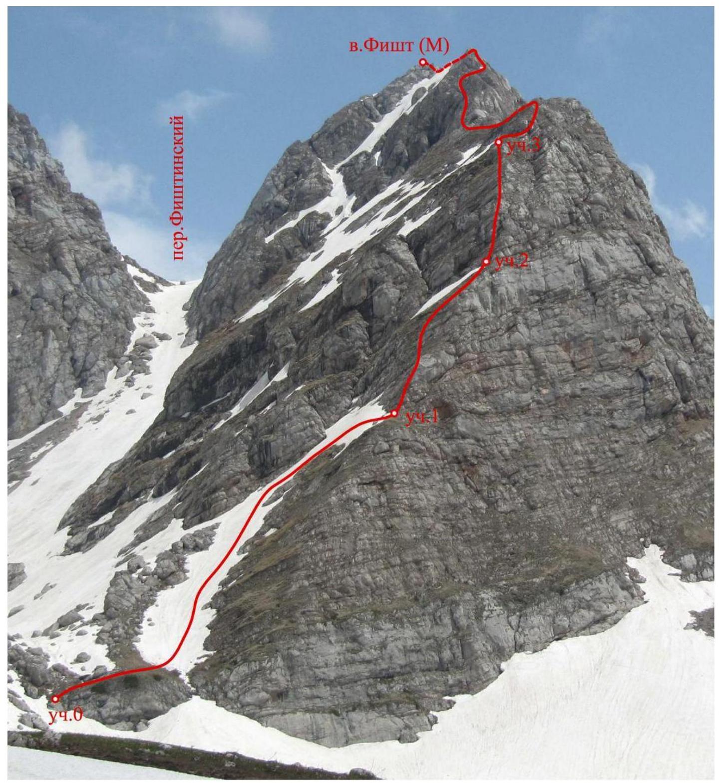
Figure 1 – Fisht Maly from the west (photo taken from under the route on May 10, 2014)
Photograph of the route profile
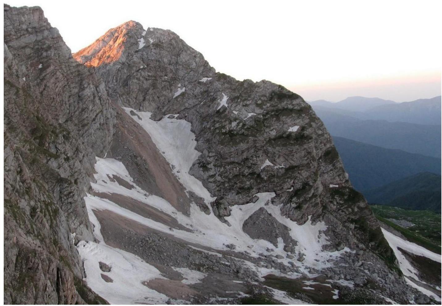
Figure 2 – Photograph of the western ridge of Fisht Maly from the left (photo taken from the southwestern edge of Fisht peak on June 11, 2012)
Panorama of the area
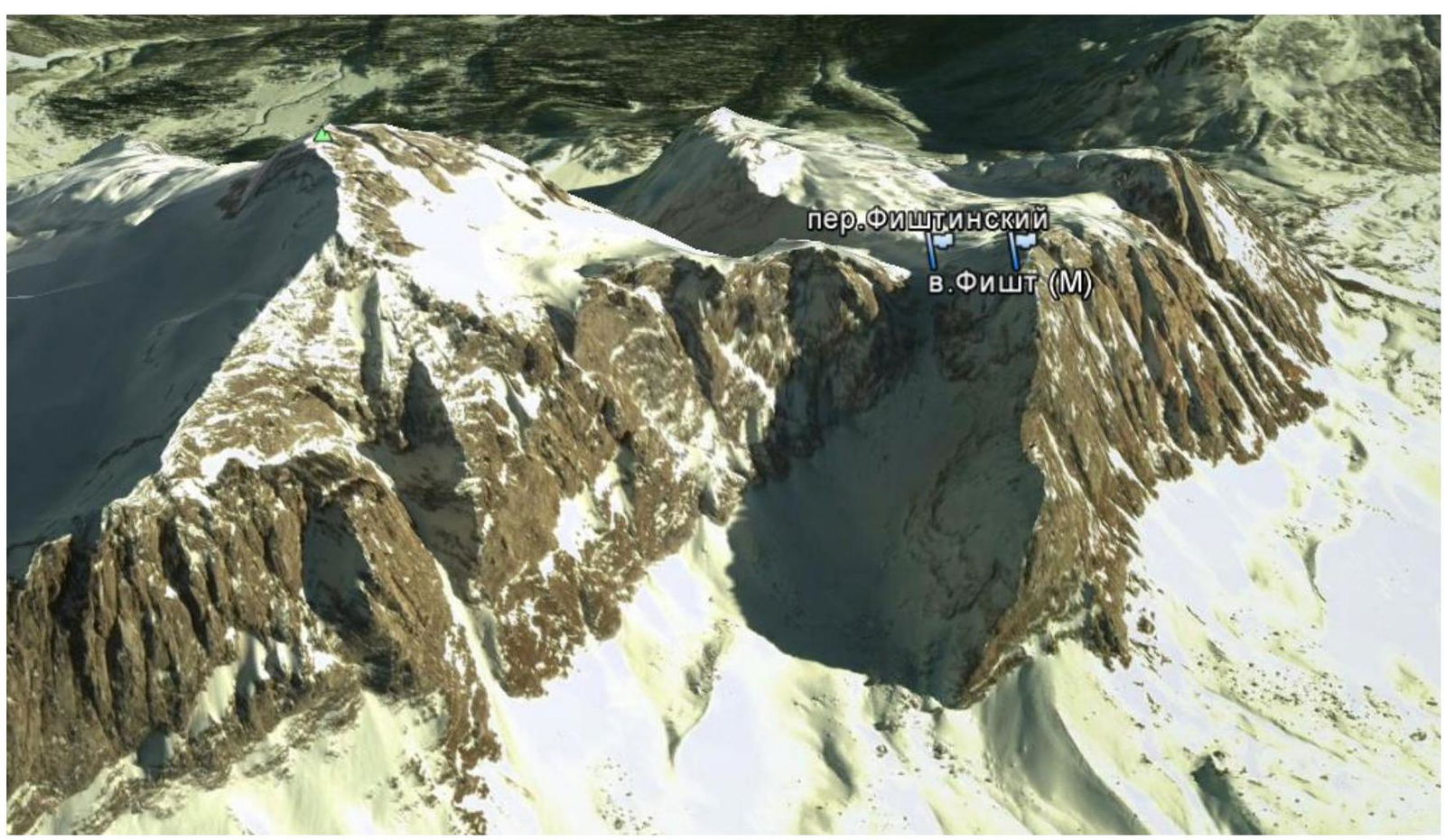
Figure 3 – Image of Fisht and Fisht Maly peaks from the west (image made in Google Earth)
Description of the climbing object
The Fisht-Oshten mountain range is a frequently visited, easily accessible, and well-studied area. There are 9 classified routes to the summit of Fisht, ranging from 1B to 5A category of difficulty. To the south of Fisht peak is Fisht Maly peak (2554 m), separated from the main peak by Fishtinsky Pass (2442 m).
There are mentions of Fisht Maly peak in various articles. An excerpt from Yuri Koshelenko's report on his expedition to the Fisht area in 2001:
"To the right, the ridge [Southern ridge of Fisht peak] descends quite gently to a saddle, separating the main massif from Fisht Yuzhny…
Fisht Yuzhny is a separate peak, also of significant interest to climbers…
Excerpt from Maxim Foygel and Vladimir Khrabovchenko's article "Geographical and alpinist overview of Fisht massif and Lagonaki highland": "South of Fisht's main peak is another small peak. It lies between Fishtinsky Pass and Belorechensky Pass, forming a separate massif connected to Fisht by a southeastern ridge. Between this massif and Fisht is the Maly Fishtinsky glacier. In his report, Yu. Koshelenko refers to this peak as Fisht Yuzhny. However, it would be more accurate to call it Fisht Maly. Firstly, this name has been used for the mountain in speleological reports since the 1970s. Secondly, this name is reasonable by analogy with the practice adopted in the Caucasus. For example, in the Belalakaya massif, two peaks separated by Belalakaya Pass are called Belalakaya and Malaya Belalakaya. Thirdly, the glacier at the foot of the massif is also named after Maly Fisht."
In addition, it is worth noting:
- there are classified routes on Fisht Severny, i.e., an analogue of the name for a secondary peak of Fisht by cardinal directions;
- tourists (including in a note on the summit) refer to the peak as Fisht Maly.
Based on the information above, the team of first ascenders tends to adopt the name Fisht Maly for this peak.
The peak has a simple ascent from Fishtinsky Pass (the pass itself has a 1B category of difficulty), so the peak is often visited by tourists.
Description of the approach to the route and descent from the summit
It is advisable to start the approach to the route from the "Vodopadisty" shelter. From Chernigovskoe village (Apsheronsky district), 5 km along an asphalt road and 37 km along a dirt mountain road to a gully on the road. Then on foot for 1 hour to the "Vodopadisty" shelter. From the shelter, follow along the western and southern walls of Fisht towards Cherкесский Pass. Before reaching the pass, turn left under the base of Fishtinsky Pass. From the shelter – 3-4 hours.
It is also possible to approach the route from the side of Babuk-Aul or the "Fisht" shelter.
Descent from the summit to Fishtinsky Pass is via simple rocks and snowfields. From the pass, depending on the location of the base camp:
- to the west along a snowy couloir (scree in the second half of summer)
- to the east along the Maly Fishtinsky glacier.
It should be taken into account that the peak and the approach path are located within a protected area, and entry without permits is prohibited.
Coordinates of Fisht Maly peak: latitude – 43°56′33.81″ N, longitude – 39°54′13.46″ E
Map of the climbing area
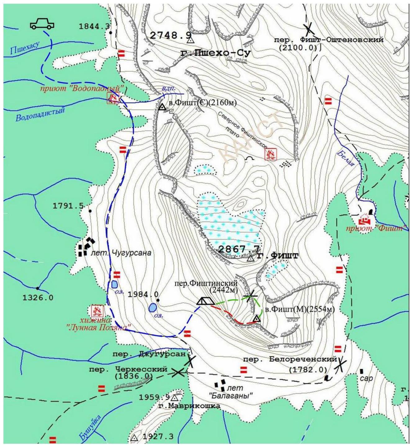
Figure 4 – Map of Fisht massif
Legend:
- approach
- route
- descent
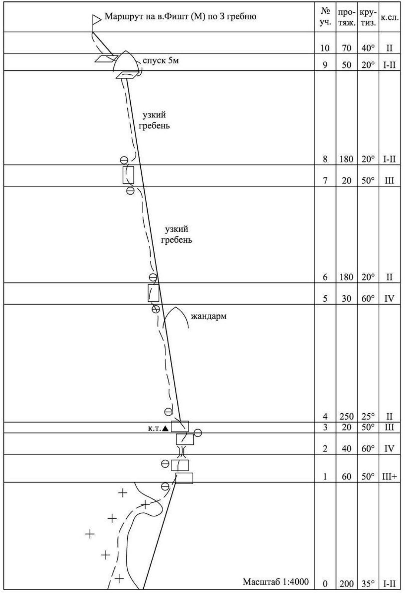
Route diagram in UIAA symbols
Technical photograph of the route
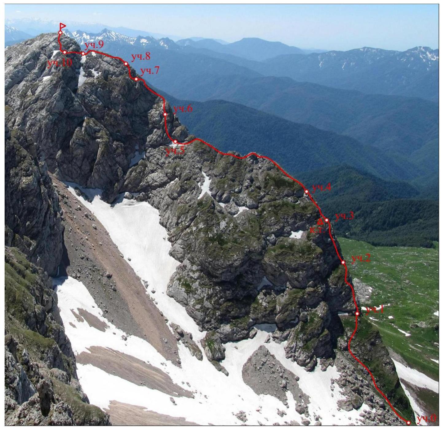
Figure 5 – Technical photograph of the route (photo taken from the southwestern edge of Fisht peak on June 11, 2012)
Route description
R0–R1 – 200 m, 35°, I–II Ascent along the snowfield on the left side of the ridge, then ascent to the ridge before a rock step. (When the snowfield melts – movement along the ridge itself).
R1–R2 – 60 m, 50°, III+ Along the walls of the ridge under a small chimney.
R2–R3 – 40 m, 60°, IV Through a 5-meter chimney, then along a smooth wall.
R3–R4 – 20 m, 50°, III Along inclined slabs and a wall, exit to a flattening ridge.
R4–R5 – 250 m, 25°, II Along the ridge to a small depression in the ridge with a gendarme.
R5–R6 – 30 m, 60°, IV Along a difficult wall on the left side of the ridge through an implicit inner angle (loose rocks!)
R6–R7 – 180 m, 20°, II Along a narrow ridge to a rock ascent. Traverse left under a small wall.
R7–R8 – 20 m, 50°, III Along the wall, exit to a flattening ridge.
R8–R9 – 180 m, 20°, I–II Along a narrow ridge to a large gendarme.
R9–R10 – 50 m, 20°, I–II The gendarme is bypassed on the right. Descent to a saddle behind the gendarme.
R10—summit – 70 m, 40°, II Along a wide ridge, exit to the summit.
Route characteristics
The route follows the edge of the western ridge along the most logical and simple sections. The ridge has two ascents with an average steepness of up to 60°, alternating with more gentle sections.
The ridge is composed mainly of limestone rock. The rock is generally strong, but there are layers of more weathered rock.
Due to the relatively low altitude and southern exposure, there is grass on the lower part of the route on gentle slopes and ledges during the warm season.
The key sections of the route require good climbing and belaying skills due to the highly smoothed micro-relief.
Anchor pitons are the best option for creating belay points, although "friends" and chocks can also be used.
Notes from control tours and the summit
On the route, a control tour is left on section 3. Note in the control tour on the summit:
"On October 14, 2013, at 8:10, a group of climbers from the 'Zvezda' military-patriotic camp reached the summit of Maly Fisht via the western couloir on the northeastern slope, category 1A, consisting of 19 people. Leader Morozov A.E."
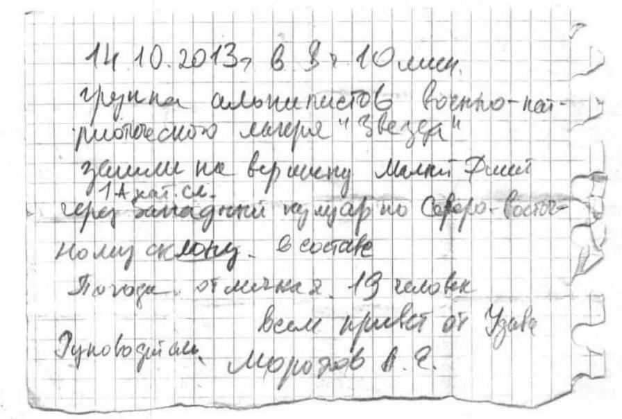
Figure 6 – Note from the summit
Photo illustrations

Photo 1 – Section R2–R3. Sharov working in the chimney.
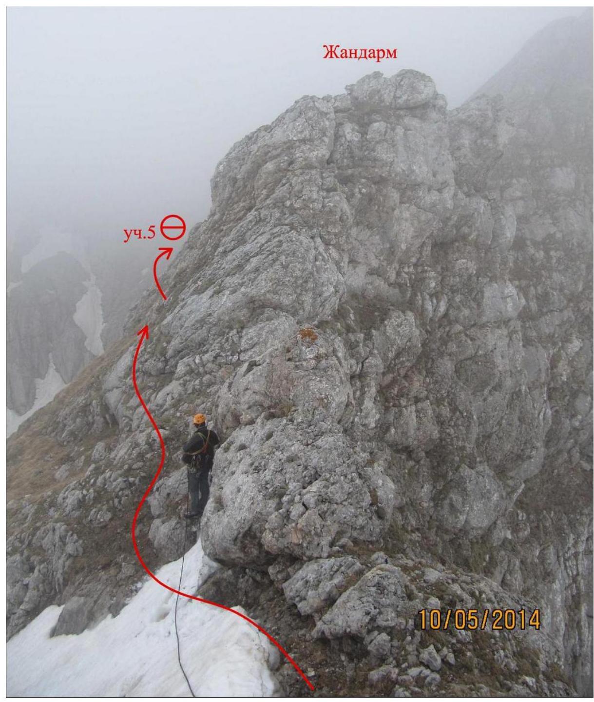
Photo 2 – Section R4–R5. Leader bypassing a gendarme.
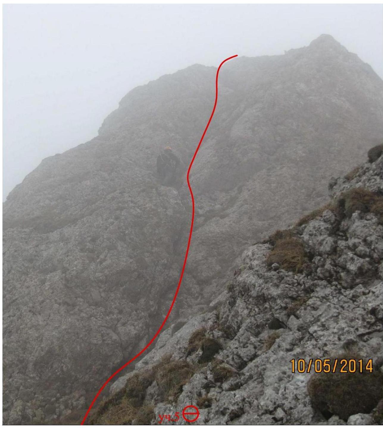
Photo 3 – Section R5–R6. Passing a complex wall. Second key section.
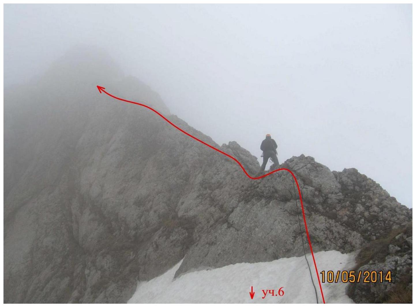
Photo 4 – Section R6–R7. Passing a narrow ridge.

Photo 5 – Section R6–R7. View of the ridge from above.
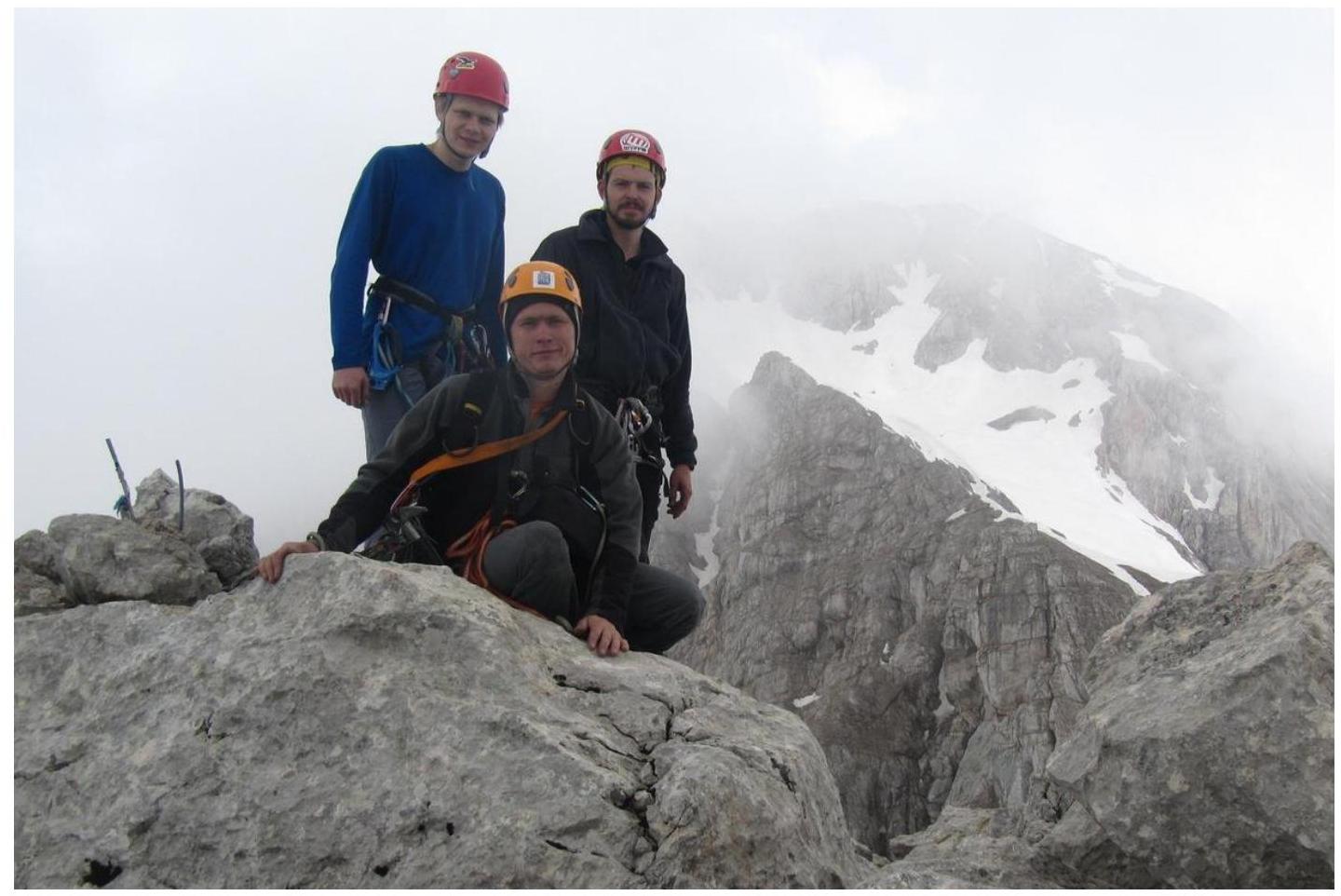
Photo 6 – Summit. In the background, Fisht peak and the SW ridge.
From left to right and top to bottom:
- Skvortsov Nikolai
- Ivashchenko Mikhail
- Sharov Mikhail
General conclusion on the route
When determining the complexity of the route, the team used experience from previous ascents. Considering the geographical location, climatic conditions, and relief specifics of the Fisht-Oshten massif, the team primarily considered previously climbed routes of similar complexity in the area:
- Fisht via the NE ridge, category 2B;
- Fisht via the SE wall, category 3A;
- Fisht via the 3rd ridge, category 3B;
- Oshten via the right part of the NW wall, category 2B.
The team also considered routes climbed in other mountain areas:
- VMF via the 3rd ridge, category 2B;
- MNR (NE) via the S ridge, category 3A;
- Chatbashi via the N face, category 3A;
- Kirpich from Myrdy Pass, category 3A.
After analyzing these routes, the team concluded that the route on Fisht (M) via the western ridge exceeds the complexity of category 2B routes and is comparable to category 3A routes.
The route is characterized by:
- sufficient length,
- complex climbing on key sections,
- areas with highly smoothed micro-relief.
To climb the key sections of the route, good climbing and belaying skills are required.
In this regard, this route cannot be recommended for training groups making their first category 3A ascent. However, it is of interest to sports teams as an object for training ascents.
Based on the above, the team proposes to classify this route as category 3A.
Footnotes
-
- The justification for the name of the peak adopted by the authors of this report is reflected on sheet 6. The height is measured by GPS.
Comments
Sign in to leave a comment