Report
on the ascent to v. Fisht (2867 m) through the center of the eastern wall, first ascent, approximately 4B category of difficulty, completed by the team of the KubSTU "Shтурм" mountaineering section
Ascent Passport
-
Western Caucasus, Krasnodar Krai, 2.1
-
Fisht peak (2867 m) via the center of the eastern wall
-
Proposed category of difficulty – 4B, first ascent
-
Route type: rock
-
Route height difference – 920 m Route length – 1950 m. Wall section height difference – 710 m. Wall section length – 1200 m. Section lengths:
- IV category of difficulty – 185 m
- V category of difficulty – 195 m. Average steepness:
- wall section of the route: – 60°
- entire route: – 40°
-
Pitons used on the route (including those for ITO in the denominator): rock pitons – 50; protection elements – 62; bolt pitons – 0; Pitons left on the route: 0.
-
Team's total climbing hours: 17 hours, 2 days Number and characteristics of bivouacs:
- one bivouac – comfortable, in a tent.
-
Descent from the summit: via route 1B category of difficulty on the northern slope.
-
Leader: Spesivstev Artem Alekseevich, Candidate Master of Sports Participants:
- Ivashchenko Mikhail Nikolaevich, Candidate Master of Sports
- Minakov Dmitriy Gennadievich, 1st sports category
-
Coach: Shaulskiy Dmitriy Sergeevich, Candidate Master of Sports
-
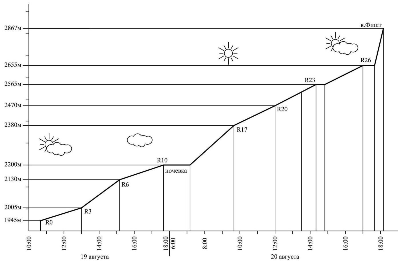
Route entry time: 10:30, August 19, 2011 Summit arrival time: 18:10, August 20, 2011 Return to "Fisht" refuge time: 20:40, August 20, 2011
-
Organization: Krasnodar Regional Mountaineering Federation, Krasnodar www.alpinism.ru↗
-
Report responsible: Ivashchenko M.N. indeeccc@gmail.com
General Photo of the Summit
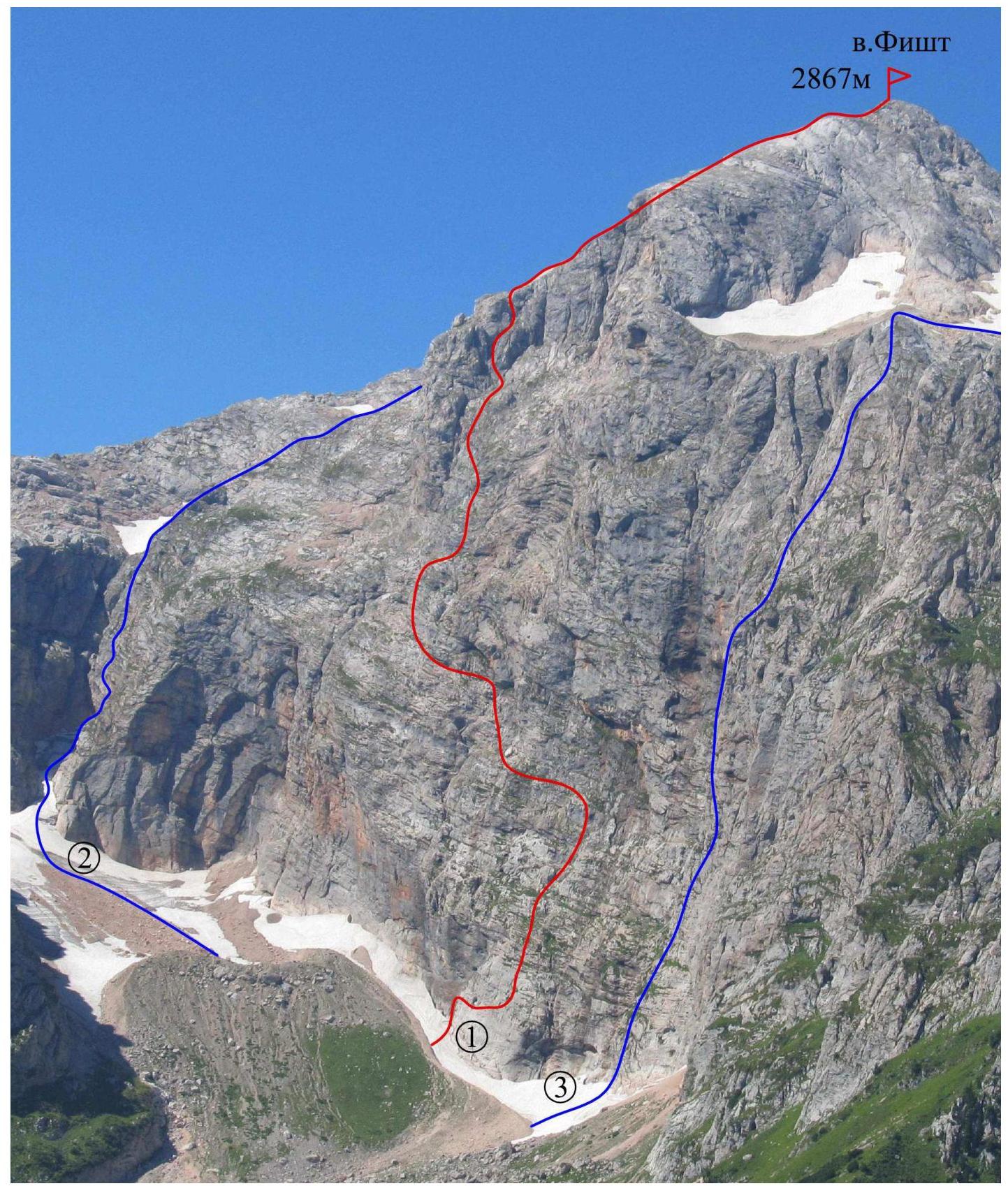
Figure 1 – Fisht from the northeast (photo taken from the Armenian ridge on August 21, 2011)
- 1 – center of the eastern wall, approx. 4B – route completed by the team
- 2 – southeastern wall, 3A (M. Foigel, 2001)
- 3 – eastern wall, 5A (A. Andryushchenko, 85)
Photograph of the Wall Profile
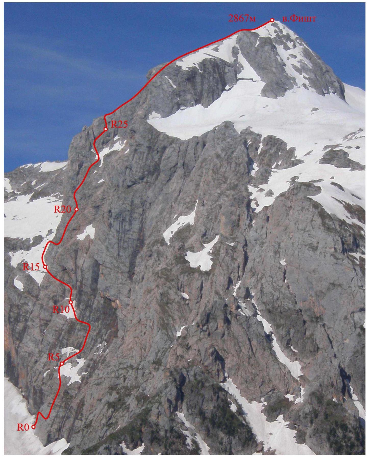
Figure 2 – Photograph of the eastern wall from the right (photo taken from the Armenian pass (1866 m) on June 12, 2009). The wall's position makes it difficult to capture a full profile photo.
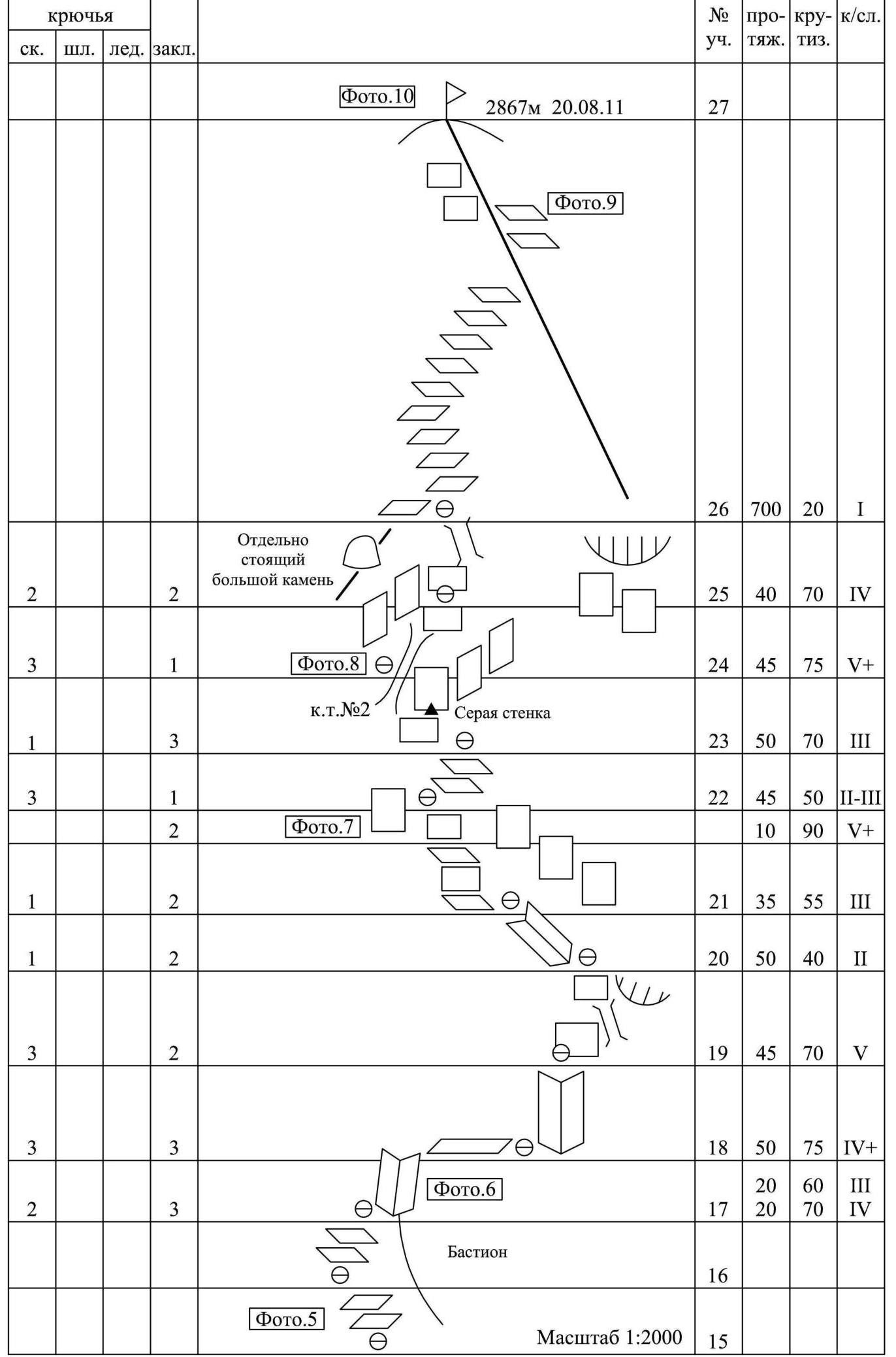
Drawn Route Profile
The profile shows the wall section of the route up to the ridge exit. The characteristics include:
- section lengths;
- average terrain steepness.
Scale 1:3000

Area Photopanorama
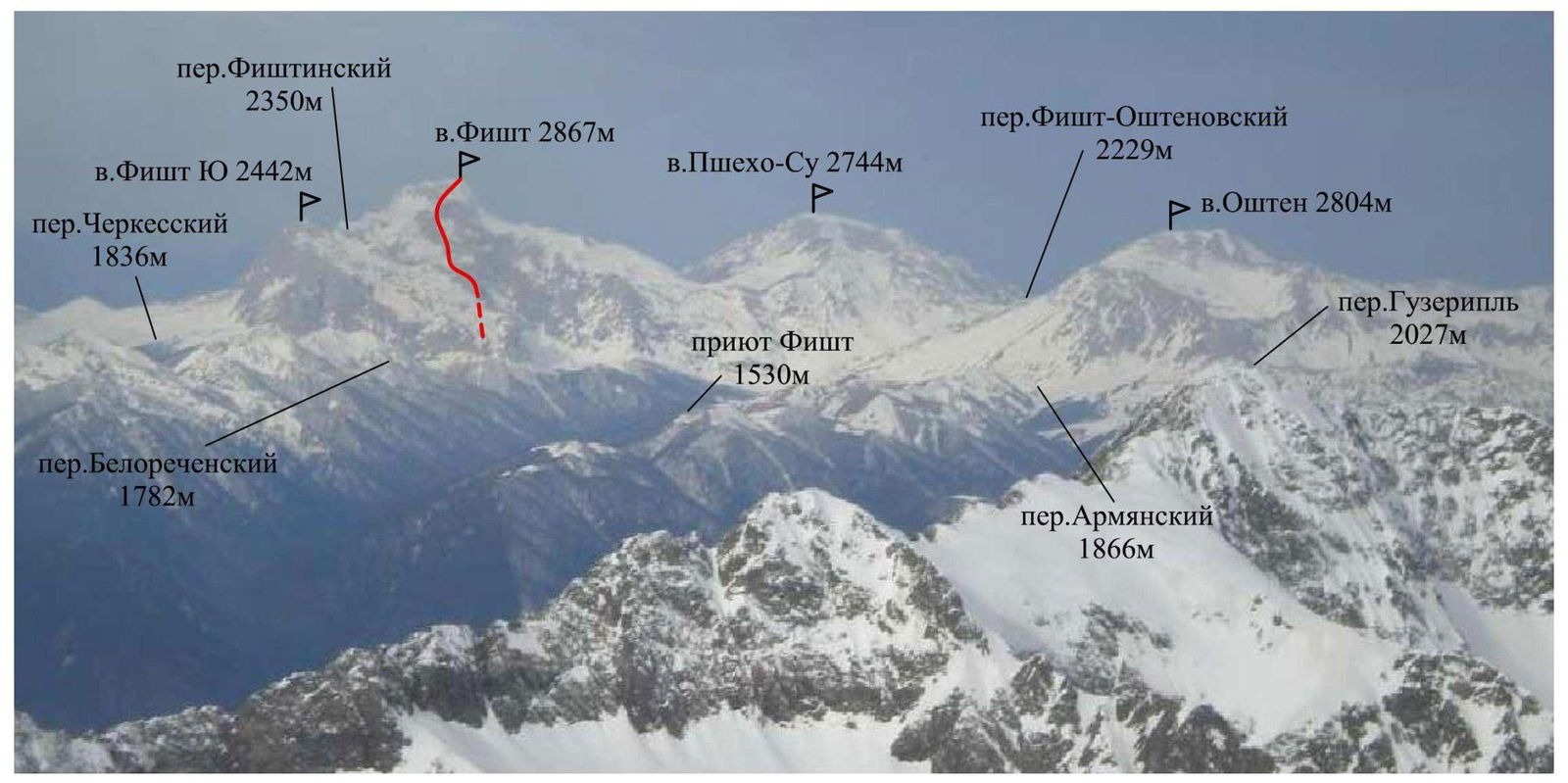
Figure 3 – Fisht-Oshten mountain range from the southeast (photo taken from v. Chugush in December 2010)
Ascent Graph
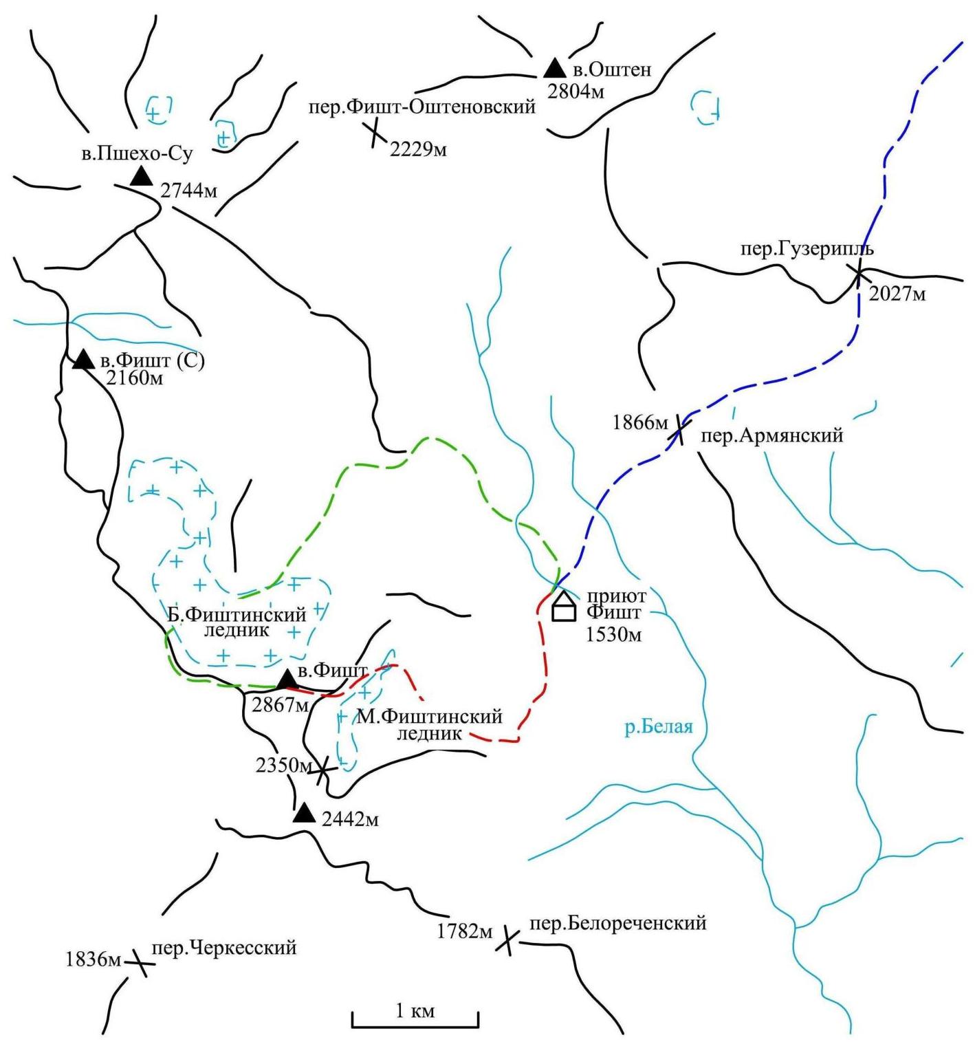
Approach to the Route Description
Ascents to Fisht mountain usually start from the "Fisht" refuge, located directly under the mountain slopes. It's more convenient to get here via the Guzeripl settlement. Upon entering the settlement, turn right at the first T-junction and follow the asphalt road past the "Partizanskaya Polyana" refuge until it ends (about 18 km). Then, continue on foot along the marked trail:
- Through Guzeripl pass
- Through Armenian pass
- Bypassing the slopes of Oshten mountain to the left
to the "Fisht" refuge. From the road, it takes 3–4 hours (11 km).
From the "Fisht" refuge, follow the marked trail leading to the Belorechensky pass. At the marked point, turn right towards the Small Fishtinsky glacier. Continue straight along the trail, then across the scree – under the eastern wall of Fisht mountain.
The path from the "Fisht" refuge:
- 1 hour.
Area Map-Scheme
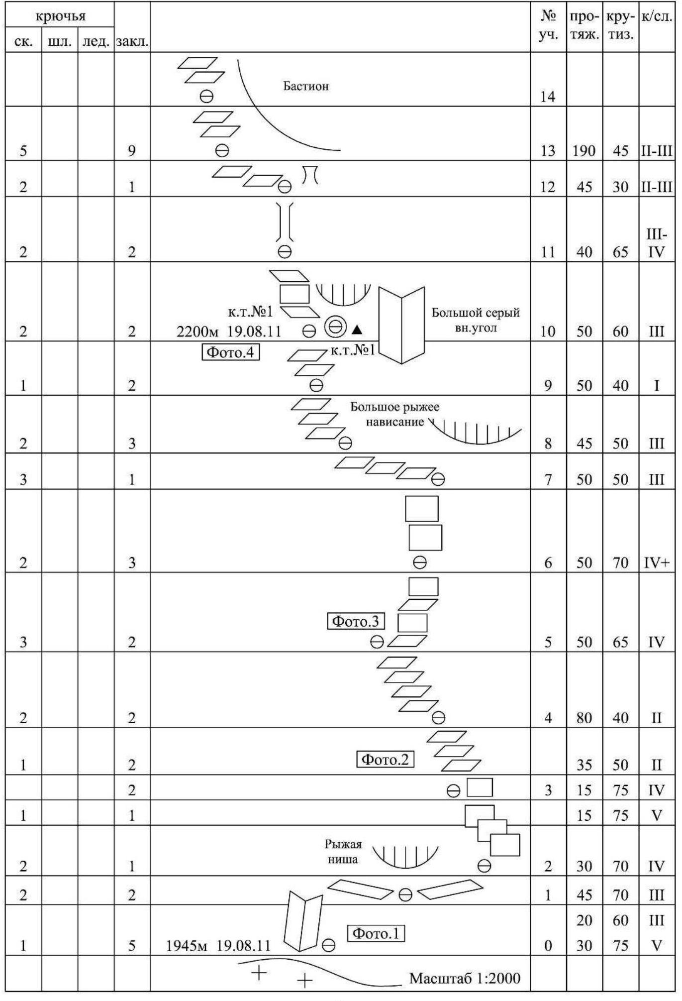
Route Scheme in UIAA Symbols
Technical Photograph of the Route
Figure 4 – Technical photograph of the center of the eastern wall (photo taken from the Armenian ridge on August 21, 2011)
Route Description
The start of the route is below and to the left of the red niche on the gray wall. R0–R1 – 30 m, 75°, 5; 20 m, 60°, 3. Up the corner, then along the ledge traverse right under the niche. R1–R2 – 45 m, 70°, 3. Traverse right along ledges and small walls. R2–R3 – 30 m, 70°, 4; 15 m, 75°, 5. Bypassing the overhang on the right, up through small walls and steep slabs. R3–R4 – 15 m, 75°, 4; 35 m, 50°, 2. Up the small wall, then along simple ledges left-up. R4–R5 – 80 m, 40°, 2. Along the simple slope left-up towards the large red cornice. R5–R6 – 50 m, 65°, 3–4. Through a series of short walls under the smooth wall. R6–R7 – 50 m, 70°, 5+. Up the wall to a system of ledges. R7–R9 – 95 m, 50°, 3. Along the ledges left under the red overhang to a large gully (stream). R9–R10 – 50 m, 40°, 1. Up the gully, then to its left edge. There's a convenient platform next to the stream under the cornice on the right.
R10–R11 – 50 m, 60°, 3. Up to the chimney through small walls. R11–R12 – 40 m, 65°, 3–4. Up the chimney, then left onto a ledge. R12–R13 – 45 m, 30°, 2–3. Traverse left along ledges. R13–R17 – 190 m, 45°, 2–3. Left-up along the simple slope, bypassing the bastion wall. R17–R18 – 20 m, 70°, 4; 20 m, 60°, 3. Right along a short corner onto the bastion wall, then traverse right along a ledge. R18–R19 – 50 m, 75°, 4+. Up a large corner-gully under the gray wall. R19–R20 – 45 m, 70°, 5. Right of the wall up the corner, then the chimney, and through the wall. R20–R21 – 50 m, 45°, 2. Along a large gully along the wall left-up past caves. R21–R22 – 35 m, 50–60°, 3; 10 m, 90°, 5+. First along the wall, then through the wall at its lowest point. R22–R23 – 45 m, 45°, 2–3. Up a system of ledges – exit into a large rock amphitheater formed by two pre-summit ridges.
R23–R24 – 50 m, 70°, 3. Left to the smooth gray wall (with a control cairn at its base), then bypassing it on the left along a gully to its left edge.
R24–R25 – 45 m, 75°, 5. Up the gully (loose rocks!) through small walls. R25–R26 – 40 m, 70°, 4. Bypassing the overhang on the right, ascent to a large chimney with a large stone at the bottom. Through the wall, exit onto the ridge.
R26–R27 – 700 m, 20°, 1. Along the simple ridge to the summit.
Route Characteristics
The route passes through the center of the eastern wall, left of the waterfalls in the lower part and the bastion of the eastern ridge in the upper part, and exits onto the eastern ridge of the summit.
The route follows the most logical and simple sections. The general direction of movement:
- from the gray wall up towards the large red overhang;
- under it, traverse left;
- then left-up, bypassing the bastion on the left;
- exit onto it and along its left part – exit onto the ridge with a large separate stone;
- exit to the summit along the ridge.
The route is characterized by its significant length. Sections of traverses are common. The entire route can be divided into three sections:
-
the first section;
-
the second section;
-
the third section.
-
the lower part of the wall – a wide steep slope-wall, 450 m long;
-
the middle part of the wall – movement along the bastion and exit onto the ridge, 800 m long;
-
the pre-summit ridge, 700 m long.
Two control cairns are left on the route:
- at the bivouac R10;
- on the section R23–R24 on the ridge wall.
Good bivouac sites are available:
- under the cornice R10;
- in the grotto R12;
- on the ridge R26–R27.
Additionally, sufficiently large ledges for building platforms are encountered in the middle part of the wall.
Water is available in the lower part of the wall – streams (R4–R6 and R9–R10) flow not from melting snowfields but from cracks in the wall from the melting glacier, so they do not dry up even in hot weather.
There's a lot of grass on the ledges. In conditions of poor visibility, orientation on the route may be problematic. Friends and anchor pitons are well-suited for the route.
Notes from Control Cairns and the Summit
Control cairns are left on the route:
- at the bivouac R10 on a ledge;
- on the section R23–R24 on a ledge under the smooth gray wall.
No notes were found in the control cairn at the summit.
Photo Illustrations
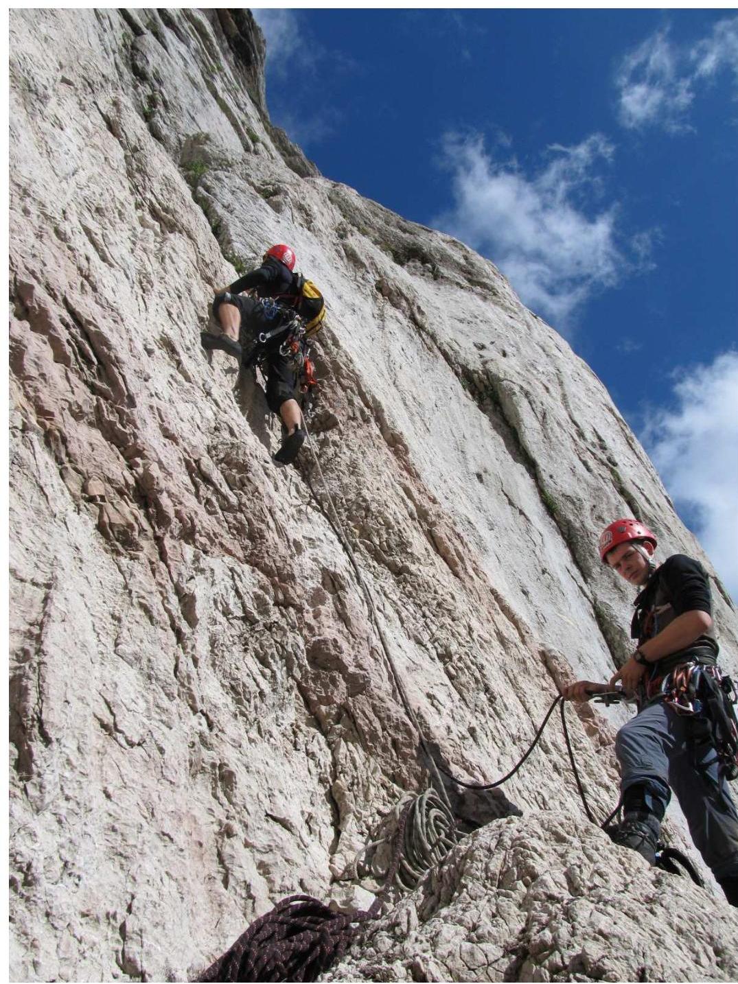
Photo 1 – Section R0–R1. Spesivstev starts working on the route.
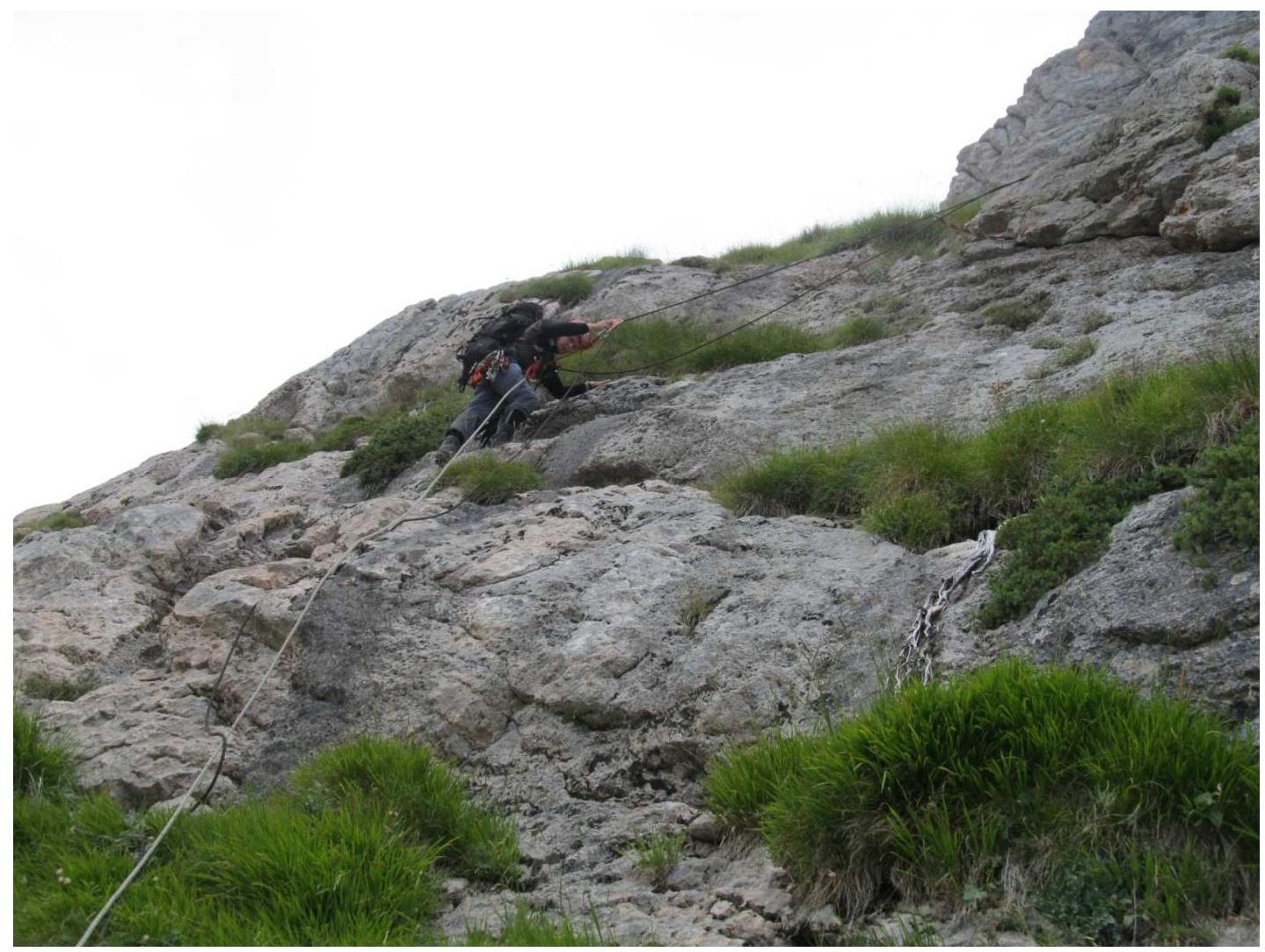
Photo 2 – Ivashchenko moving along the fixed ropes on section R3–R4.
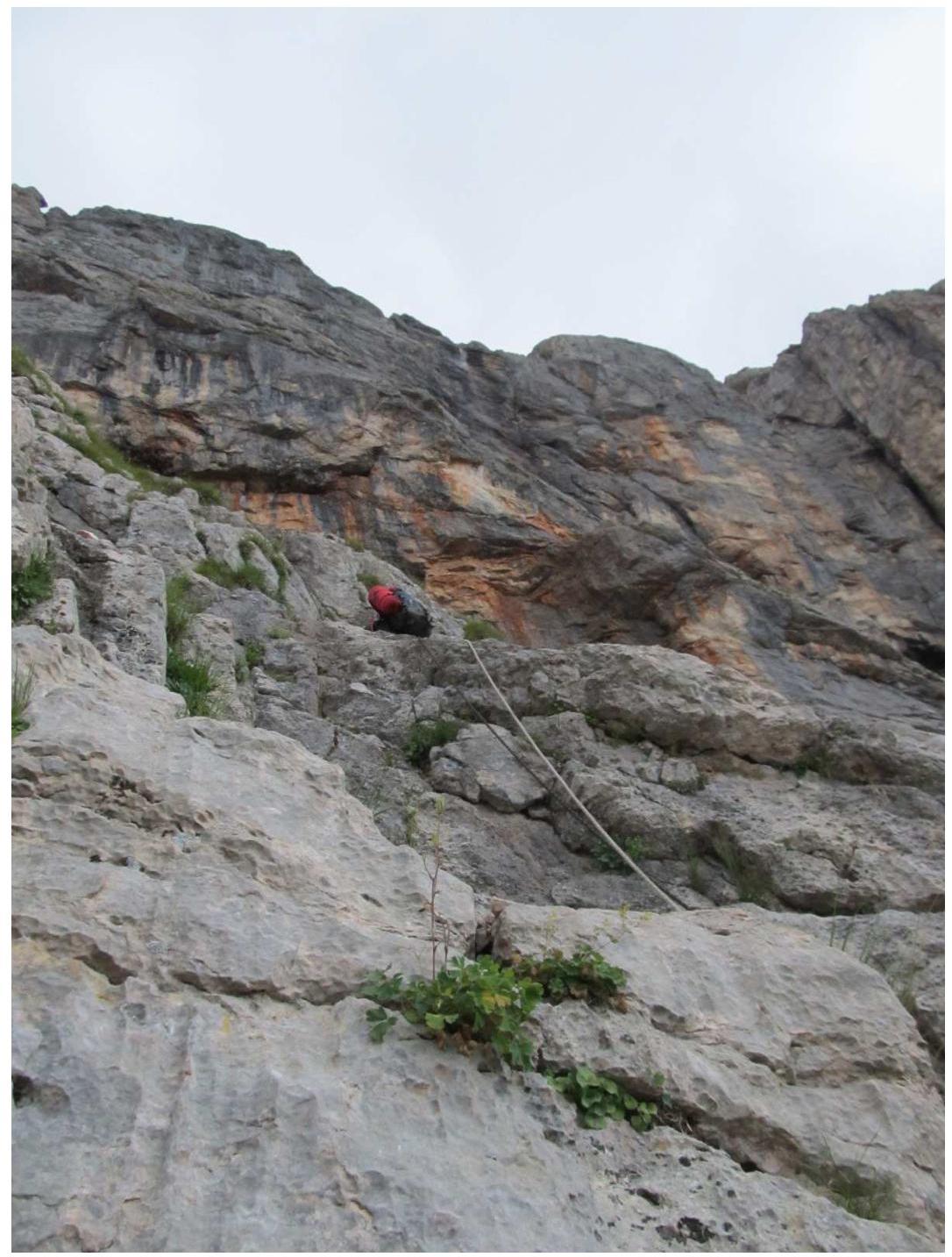
Photo 3 – Section R5–R6. Large red overhang.

Photo 4 – Section R10. Bivouac site.
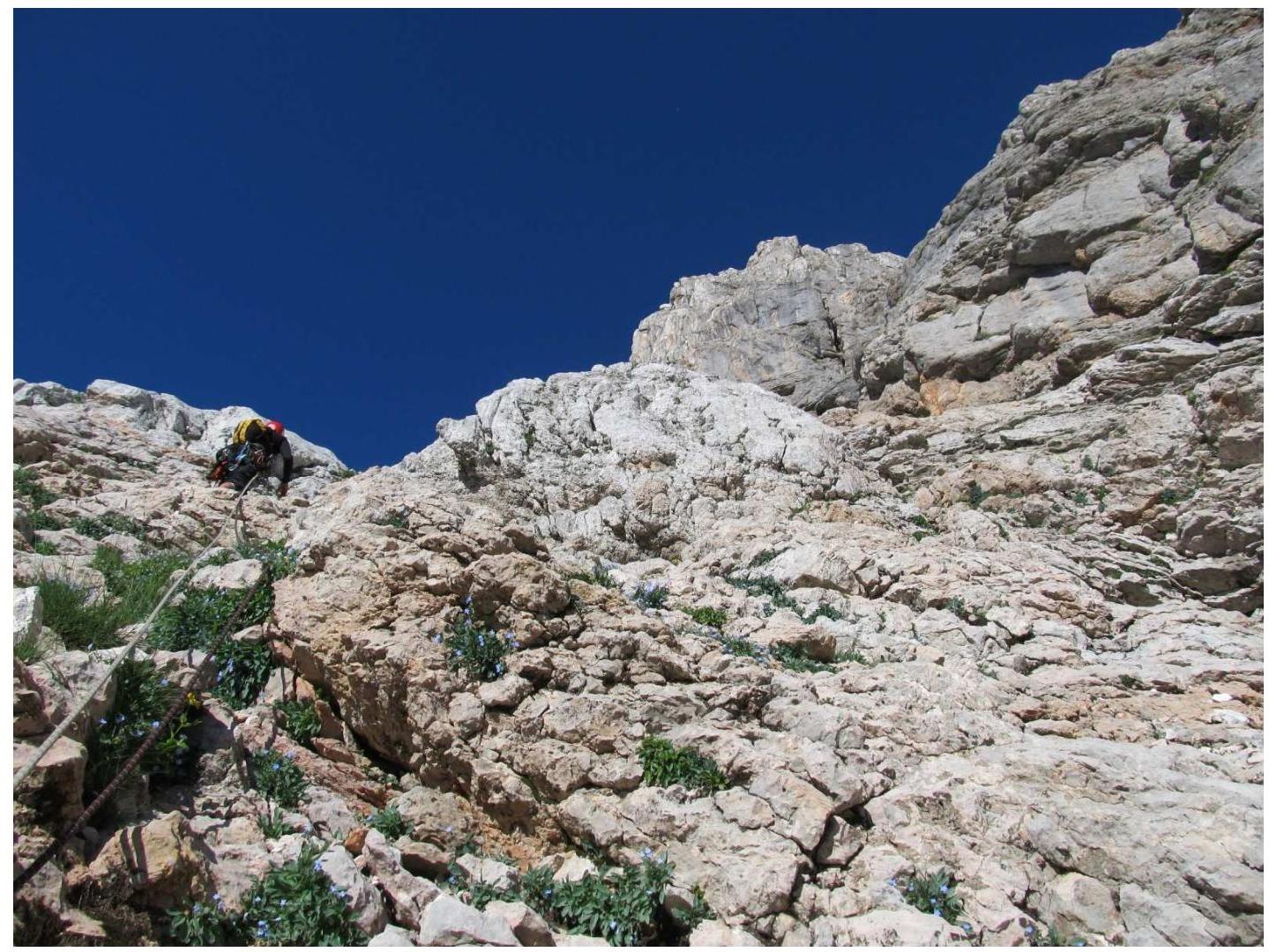
Photo 5 – Section R15–R16. Movement along the bastion.
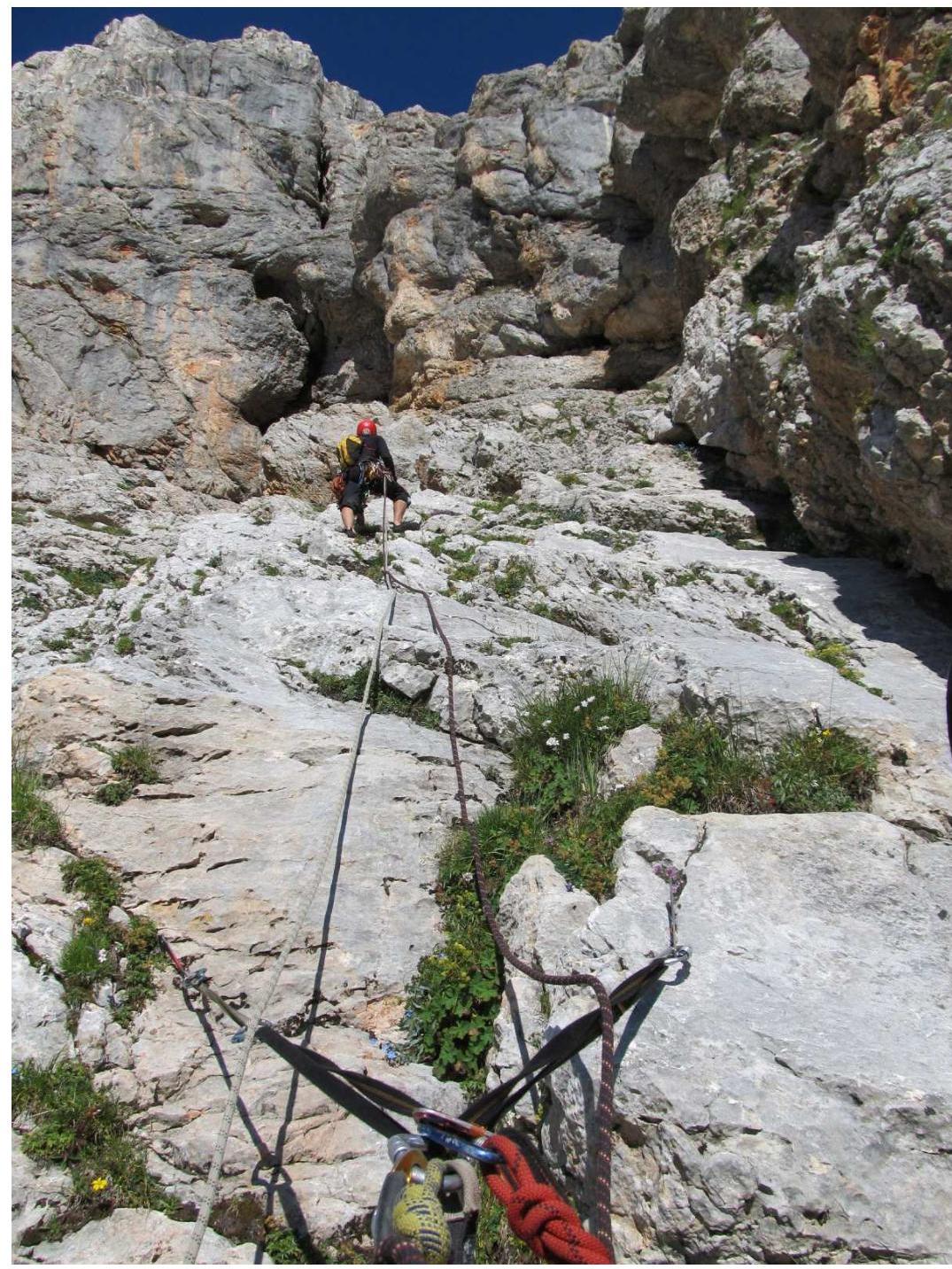
Photo 6 – Section R17–R18. Spesivstev searching for a way onto the bastion on the right.

Photo 9 – Pre-summit ridge.

Photo 10 – Summit. Left to right – Spesivstev Artem, Minakov Dmitriy, Ivashchenko Mikhail.
General Conclusion on the Route
The team's route through the center of the eastern wall is located between the routes on the southeastern wall (3A category of difficulty) on the left and the eastern wall (5A category of difficulty) on the right. The completed route has its own independent path and does not intersect with other routes.
When determining the route's difficulty, the group used experience from previous ascents:
- Fisht via the eastern wall, 5A category of difficulty;
- Khimik via the left edge of the northern ridge, 4B category of difficulty;
- Uilpata via the 4th spur of the southern ridge, 4B category of difficulty;
- Monk via the left southeastern edge, 4B category of difficulty.
After analyzing these routes, the group concluded that the route on Fisht through the center of the eastern wall is not less difficult than routes categorized as 4B.
The route is notable for its significant length. There are sections that require good belay organization skills.
Fisht's rocks are characterized by a large amount of grass growing from cracks even on steep sections, which sometimes causes problems with movement and belaying.
Based on the above, the team proposes to classify this route as a 4B category of difficulty.