Ascent Passport
- Climbing type: rock climbing
- Ascent area: Western Caucasus, Krasnodar Krai up to Marukh pass
- Peak, its height, and ascent route: Fisht, 2867 m, via the northern slope
- Estimated difficulty category: 1B
- Route characteristics: a) elevation gain — 1367 m; b) average steepness — 35°; c) length of sections: I — 2400 m, II — 500 m, III — none, IV — none, V — none, VI — none
- Pitons driven:
| for belaying | for creating R.I.G. (Rope Installation Gear) |
|---|---|
| Rock | — |
| Ice | — |
| Bolt | — |
- Number of travel hours — 8 hours
- Number of overnight stays and their characteristics — none.
- Group composition:
- Krivov Vasily Nikolayevich — CMS (Candidate for Master of Sports) — leader
- Taranenko Vladimir Ivanovich — CMS — participant
- Getmansky Anatoly Dmitriyevich — 1st sports category — participant
- Khakhbagurov Cherimovich — CMS — participant
- Pogosyan Fedor Liparitovich — MS (Master of Sports) — participant
- Volkovsky Viktor Zakharovich — CMS — participant
- Fukolov Alexander Vadimovich — 1st sports category — participant
- Vinogradov Alexander Alexandrovich — 1st sports category — participant
- Team coaches: Pogosyan Fedor Liparitovich, Yakovlev Sergey Yefimovich.
- Date of departure on the route: May 1, 1984
- Date of return: May 1, 1984
Brief Description of the Fisht Mountain Massif Area
The group of high massifs — Fisht, Oshten, Psheha-Su — adjoins the Lagonaki plateau and merges with it. The Lagonaki plateau is part of the system of rocky mountains. The entire system of rocky mountains is composed of Jurassic limestones. Although the rocky mountains are considered a cuesta, their formation involved not only erosion processes but also tectonic factors, ancient faults, and vertical displacements.
In the Krasnodar Krai, the entire strip of rocky mountains is 170 km long and 30–50 km wide. Within this fairly vast space, there are considerable differences in relief, climate, and vegetation, which allows the subdivision of the Western (Krasnodar Krai) mountain region into two sub-regions: Lagonaksky and Belorechensko-Urupsky. Each sub-region has several localities.
The Lagonaksky sub-region is located from the upper reaches of the Pshekha River to the middle reaches of the Belaya River, and includes: the Lagonaki plateau with the massifs of Fisht, Oshten, and Psheha-Su, the northern edge, southern edge, and western edge of Lagonaki.
The heights of the peaks are: Fisht — 2867 m, Oshten — 2804 m, Psheha-Su — 2744 m. The foundation of the massifs is composed of Paleozoic and Precambrian rocks. In the flat depression of Psheha-Su (Mount Chuba) lies Lake Psenodakh. At the foot of Mount Fisht is the shelter of the 30th All-Union Tourist Route. In the area of these massifs are the passes: Guzeriplsky — 1600 m, Armenian — 1640 m, Belorechensky — 1890 m, Cherkessky — 1700 m, Fishtinsky — 2350 m, Fisht-Oshtanovsky — 1850 m.
The Fisht shelter is located at an altitude of 1500 m. Above the shelter are: beech krummholz, fir sparse forest, and mountain meadows. Fisht has two glaciers: the Lower, small in size, lies at an altitude of 2157 m; the other glacier is located higher at 2200 m. The surface has crevasses of various widths, covered with snow. When the weather is good at the foot of Fisht, there can be fog, rain, and strong wind on the upper glacier.
In the area of Mount Fisht, the Belaya River originates. On the southern slopes and at the foot of the massif, 540 plant species grow, of which 120 species are endemics. Fisht is one of the westernmost peaks of the Caucasus of the Alpine type, reaching the boundary of eternal snows and glaciers. Due to the humid air from the south, the snowline of Fisht is at an altitude of 2650 m, which is lower than in the rest of the Caucasus (2850–3800 m) and even lower than in the Alps (2200–2800 m).
On the northern slopes of the Lagonaki plateau, snow remains even in July.
Ascent Area Map
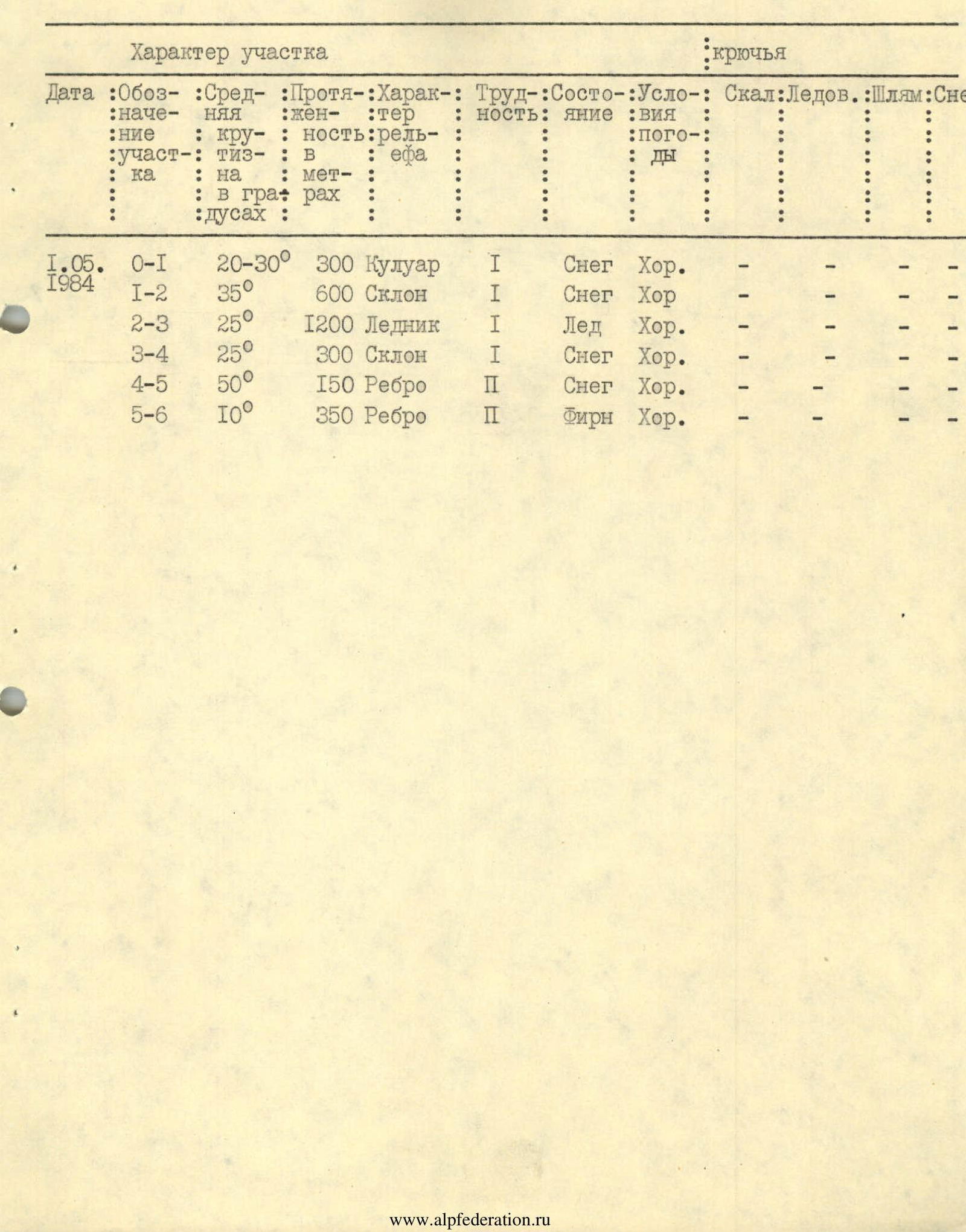
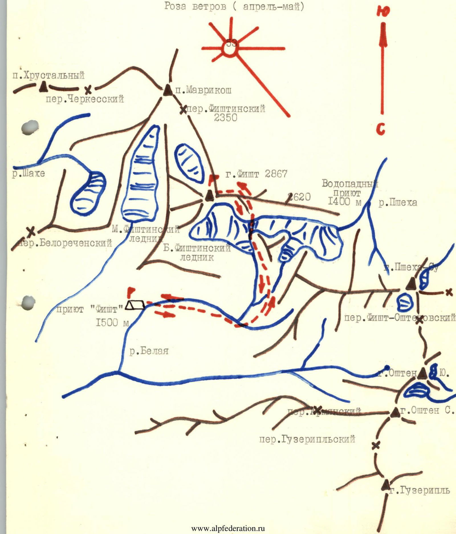 Table of main ascent characteristics
| Date | Section | Steepness (°) | Length (m) | Terrain characteristics | Difficulty | Condition | Weather | Pitons: Rock | Pitons: Ice | Pitons: Bolt |
|---|---|---|---|---|---|---|---|---|---|---|
| 01.05.1984 | R0–R1 | 20–30° | 300 m | Couloir | 1 | Snow | Good | — | — | — |
| 01.05.1984 | R1–R2 | 35° | 600 m | Slope | 1 | Snow | Good | — | — | — |
| 01.05.1984 | R2–R3 | 25° | 1200 m | Glacier | 1 | Ice | Good | — | — | — |
| 01.05.1984 | R3–R4 | 25° | 300 m | Slope | 1 | Snow | Good | — | — | — |
| 01.05.1984 | R4–R5 | 50° | 150 m | Ridge | 2 | Snow | Good | — | — | — |
| 01.05.1984 | R5–R6 | 10° | 350 m | Ridge | 2 | Firn | Good | — | — | — |
Ascent Route to Fisht Peak from the North
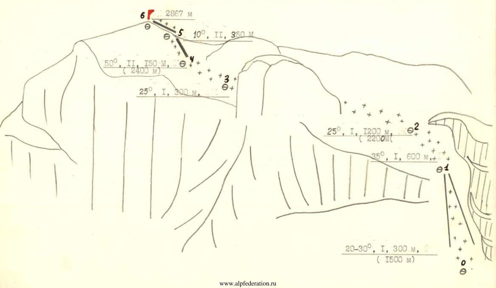
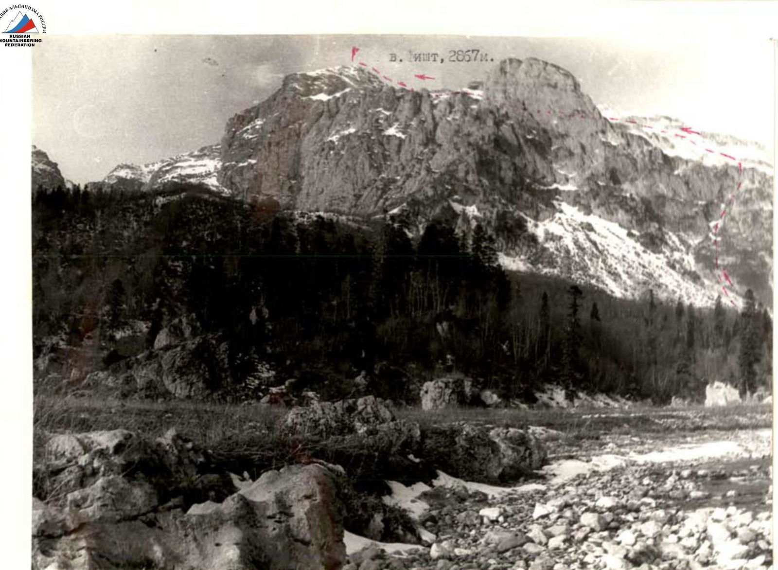 Ascent route to Fisht peak from the north.
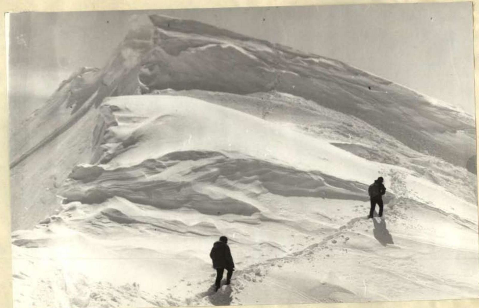 Upper part of section R4–R5.
 Height 2560 m.
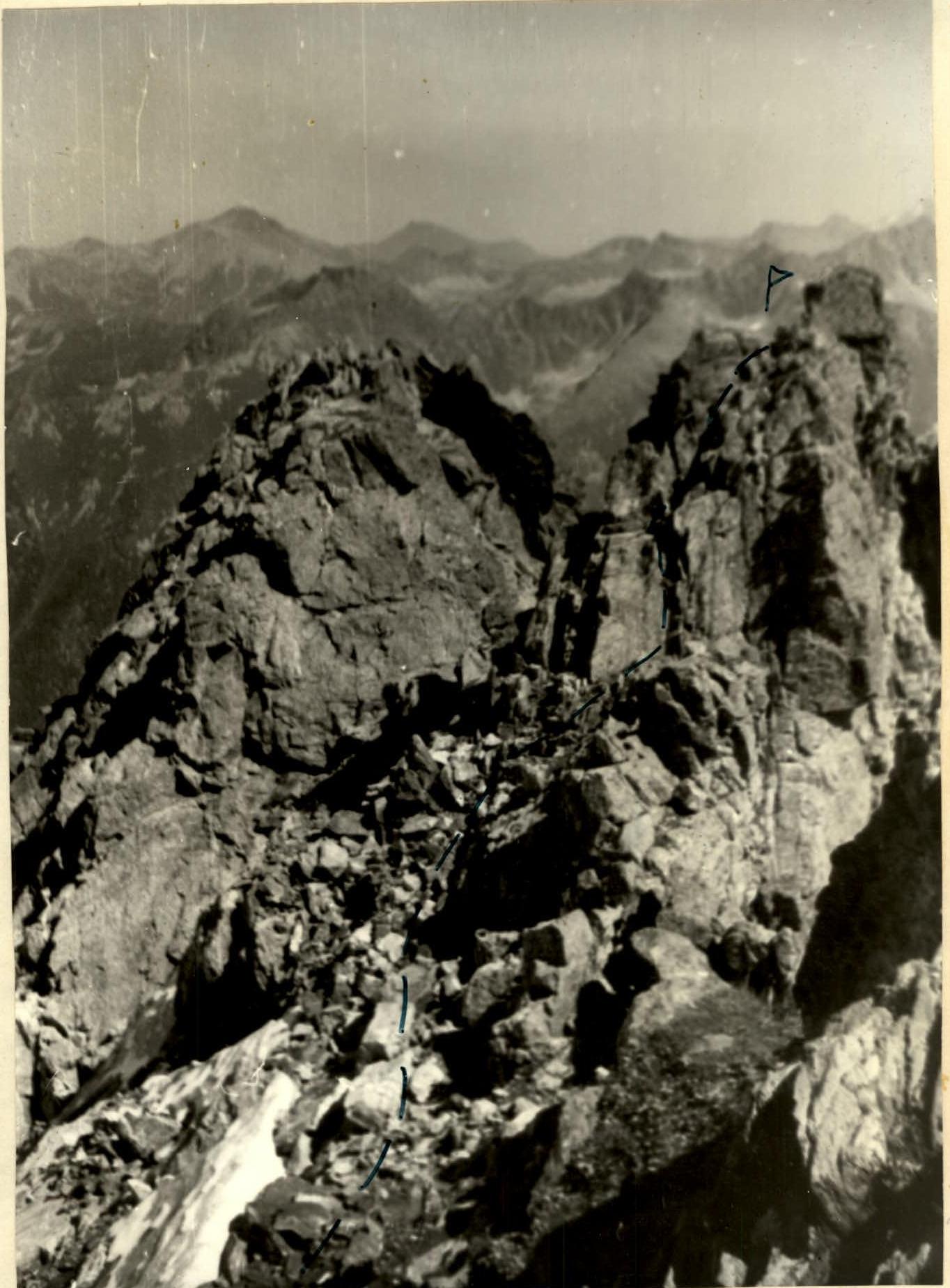 Summit