Report on the first ascent of the SW couloir of Mt. Bolshoy Tkhach (2161.0 m) via the "Otkryshka" route, approximately 2A category of difficulty, accomplished by M.V. Bogatyrev, A.Yu. Burlev, and Yu.A. Menyayev on February 6, 2008.
Table of Contents
- Ascent Passport
- Maps of the Area
- Brief Characteristics of the Area
- Approach Description
- Route Diagram in UIAA Symbols
- Summary Table of the Route
- Route and Descent Description
- Route Photographs
- General Conclusion on the Route
- Group Photo
- List of Abbreviations Used
Ascent Passport
- Ascent Category: Technical
- Ascent Area: Western Caucasus
- Peak, Route: Mt. Bolshoy Tkhach (peak 2161.0 m) via SW couloir
- Estimated Category of Difficulty: 2A, first ascent
- Wall Height Difference: 225 m; Route Length: 320 m; Average Steepness of the Entire Route: 60°
- Equipment Used on the Route (total): rock, bolt, and ice anchors — 0; friends and stoppers — 13
- Number of Climbing Hours/Days: 5 hours/0 days
- Leader: M.V. Bogatyrev (CMS); Participants: A.Yu. Burlev (3rd sports category), Yu.A. Menyayev (3rd sports category)
- Departure for the Route, Summit, and Return: February 6, 2008
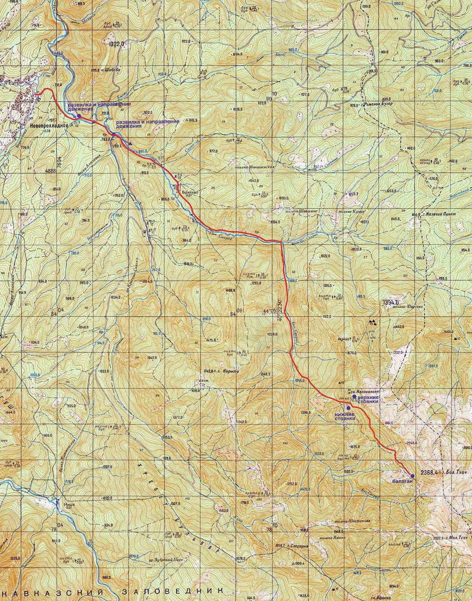
Fig. 1 (previous page). Diagram of the movement from Novoproxladny settlement (Sakhray) to the overnight stay locations — upper and lower camps, as well as the Balan.
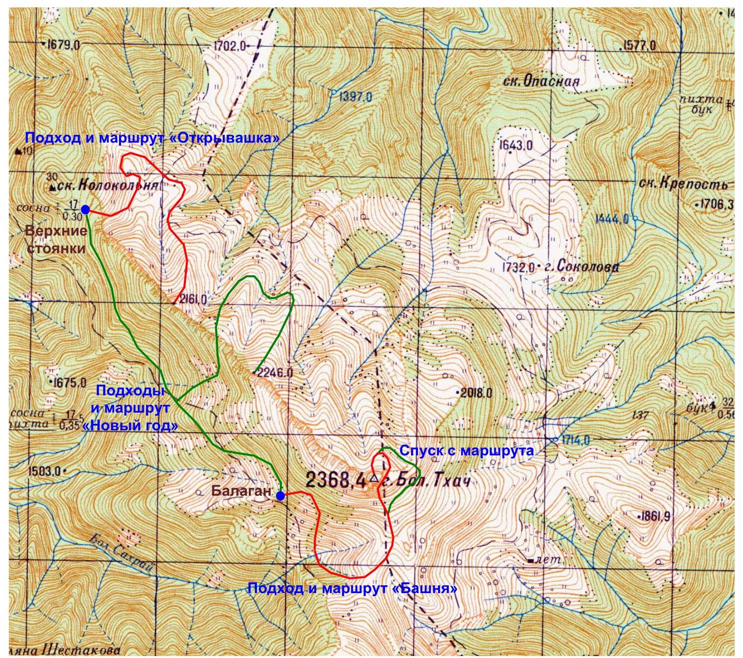
Fig. 2. Geographic map of the Mt. Bolshoy Tkhach area and the "Otkryshka," "Novy God," and "Bashnya" routes from the overnight stay locations to the three main peaks.
Brief Characteristics of the Area
Mt. Bolshoy Tkhach (2368.4 m) is located in the "Bolshoy Tkhach" natural park. This picturesque massif is situated on the border between the Republic of Adygea and the Mostovskoy district of Krasnodar Krai. Its characteristic silhouette, formed by asymmetrical peaks (gentle to the north and steep to the south) of the Bolshoy and Maly Tkhach mountains, is visible from many settlements and ridges of the Western Caucasus. The main orographic unit of the area is the Front Range, on which the peaks of Kazachiy Piket (1184 m), Bolshoy Tkhach (2368.4 m), Maly Tkhach (2238 m), Asbestnaya (2285 m), and Acheshbok (2486 m) stand out (from north to south), with the Agige (2311 m) and Sunduki (2200 m) ridges branching off to the east. Bolshoy and Maly Tkhach are known to locals as Bolshaya and Malaya Lysaya mountains, as not everyone is familiar with the geographical toponym. To the west, the massif is bounded by the Sakhray River basin (a tributary of the Belaya), and to the east — by the Khodz River basin (a left tributary of the Laba). The height difference between the summit of Bolshoy Tkhach and the surrounding riverbeds is approximately 1 km. The average annual air temperature at the nearby Kisha weather station (1500 m above sea level) is +6.9 °C, with 854 mm of precipitation per year; snow falls in November–December, and a continuous snow cover remains until mid-April. The vegetation cover is represented by fir forests, which are replaced by high-mountain maple, birch, and aspen at higher elevations, and by meadows, sometimes significantly degraded due to livestock grazing, at around 1600 m. Many meadow areas are clearly delimited by relief and have their own names: Kunske, Baronovy, Knyazheskie, Firsova, Sokolova. The fauna is quite diverse, with large animals including bison, deer, chamois, roe deer, wild boars, bears, and wolves. The local population is primarily engaged in cattle breeding and logging, but recreational activities were once developed here, and there was a refuge on the Kunske meadows serving a horseback riding route from the "Romantika" tourist base.
The wall of Bolshoy Tkhach is 10–12 km long, with a height difference of 100–300 m. The wall structure varies from destroyed rocks with grass to sheer walls and "mirrors." There are fairly logical gaps. The "mirrors" often have cornices of varying sizes.
The area is interesting for:
- Rock climbing of relatively short length (from 3 to 10 ropes);
- Bouldering — provided that the approach to route preparation and belaying is of high quality.
The area's drawbacks:
- Significant remoteness;
- Lengthy approach;
- Short route length.
Belaying features:
- On not very steep sections — complicated due to the lack of gaps ("ram's foreheads") and the destructiveness of the rock;
- As steepness increases — the wall's monolithic nature improves, and good placements for protection appear;
- On "mirrors" — belaying is complicated.
The most convenient path to Tkhach starts from the Novoproxladny settlement. Tourists and locals call it Sakhray. It should not be confused with Ust-Sakhray — a settlement about 15 km from Novoproxladny.
The road to Novoproxladny passes through Dakhovskaya:
- The main road goes to Guzeripl, and the required road turns left.
- There is a road sign.
- Almost immediately after Dakhovskaya, the road changes from asphalt to a good dirt road that a loaded car can pass without significant problems.
If traveling by public transport:
- A bus to Novoproxladny departs from Maykop around 16:00.
- The area is also accessible from another direction: by buses on the Labinsk–Mostovskoy–Uzlovoy route, and then by hitchhiking on logging trucks or on foot.
The road to Tkhach begins at the end of the settlement:
- After crossing the river over the bridge, one needs to continue along the road to the right.
- The road to the left leads to Ust-Sakhray after 12 km. It's easy to get lost on the return trip by taking this road.
- A sign "Берегите лес" (Protect the forest) serves as a landmark on the return; upon seeing it, one should immediately turn left — there will be a bridge.
By the way, there is a logging farm in Novoproxladny, so cargo trucks occasionally drive to the Tkhach area and can potentially take passengers to Taiman.
Taiman is the confluence of the Maly and Bolshoy Sakhray rivers. It's where one needs to turn off the main road.
Let's return to the beginning of the path:
- The road after the settlement is in much worse condition than before it.
- Trucks and UAZ vehicles can pass; on foot, it takes 2 to 3 hours.
- The road to Taiman is straightforward and well-traveled.
- Sometimes it runs directly along the riverbed. There are fords and detours along the banks.
- At one point, there's a fairly clear fork (on the return trip, it's no longer clear and doesn't pose a "danger"). One needs to go left, down.
- A gazebo on the right and a cairn serve as landmarks for the correct direction.
Taiman is easily recognizable by a significant widening of the road, or rather, the space to the right. Here, one needs to:
- Turn right.
- Ford the river.
- Continue straight along the overgrown forest road.
There's another road to the right and up, but it's not needed.
After about 15 minutes, a gazebo and a sign "Природный парк Большой Тхач" (Bolshoy Tkhach Natural Park) will appear on the right. Behind them:
- The road runs along the river.
- After some time, it collapses.
- Then, one simply needs to follow the riverbed where it's convenient.
After 50–60 minutes of normal walking, look for a turn to the left and up. The landmark is a small cairn, but there's no certainty it will remain, as a flood could wash it away.
After the turn, there's a well-trodden marked trail leading to Bolshoy Tkhach:
- At one point, when exiting a small clearing, there's a fork. One should go left and up.
- The trail down and to the right also seems correct — it makes a detour and returns to the main trail, but there's no certainty.
The entire journey along the marked trail takes about 3–4 hours.
There are several overnight stays under the wall. The first ones, by common names, are the lower camps.
The path to the lower camps:
- Along an abandoned logging road (the marked trail continues straight, while the road turns right), then through a clearing and a stream — into the forest.
- Another way: continue along the trail upwards; near a tree with a mark, there's a turn to the right (there's also a spot for one tent and a fire pit). Follow this trail, cross the stream, pass through the clearing, and enter the forest a bit. There will be a spot for 3–4 tents, a fire pit, and a canopy.
The second overnight stays are actually under the wall of Bolshoy Tkhach. The marked trail ultimately leads to a clearing from which the leftmost part of the rock massif's wall is visible.
The third overnight stay is the Windy Balan:
- Located 2 hours' walk from the turn on the trail to the right.
- There's a stove and tents.
- Water and firewood are relatively close.
- A panorama of the middle part of Bolshoy Tkhach's wall opens up.
To the left, on the upper camps, a rock called "Kolokolnya" (Bell Tower) rises. The lower camps, unlike the upper ones, are closer to water.
If routes on the right part of the rock massif's wall are planned, it makes sense to spend the night at the Windy Balan.
Approach Description
The approach to the ascent route begins directly from the upper campsite (see Fig. 3), located near the "Kolokolnya" rock. That is, from the campsite, one needs to move directly towards the rock wall of the Bolshoy Tkhach massif, with the "Kolokolnya" rock remaining behind. There are no established trails directly to the massif in this area, so movement will occur through a forest strip, with the steepness of the ascent increasing.
During the approach, one must constantly orient towards a large couloir (see Fig. 4), which will be bypassed on the right as one moves. Approximately 300 m later, almost at the end of the upper part of the couloir, it needs to be carefully crossed to the left part with belay. This crossing is approximately 30 m. Then, along the left part of the couloir:
- Descend down about 40 m to a large pine tree.
This is the largest pine tree (among all those standing nearby), so it's impossible to confuse it with another (see Fig. 5). From it, an internal corner (see Fig. 6) is clearly visible from bottom to top, along which the "Otkryshka" route passes.
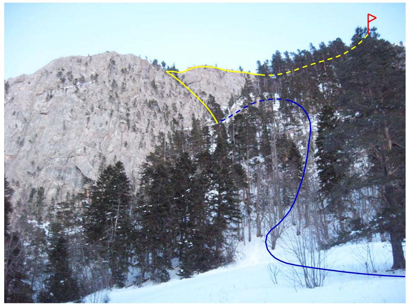
Fig. 3. View of Mt. Bolshoy Tkhach from the upper camps and tactical plan of the "Otkryshka" route (color designations: blue — approach, yellow — ascent path, red — summit; solid line — visible part of the route on the figure, dashed — invisible).
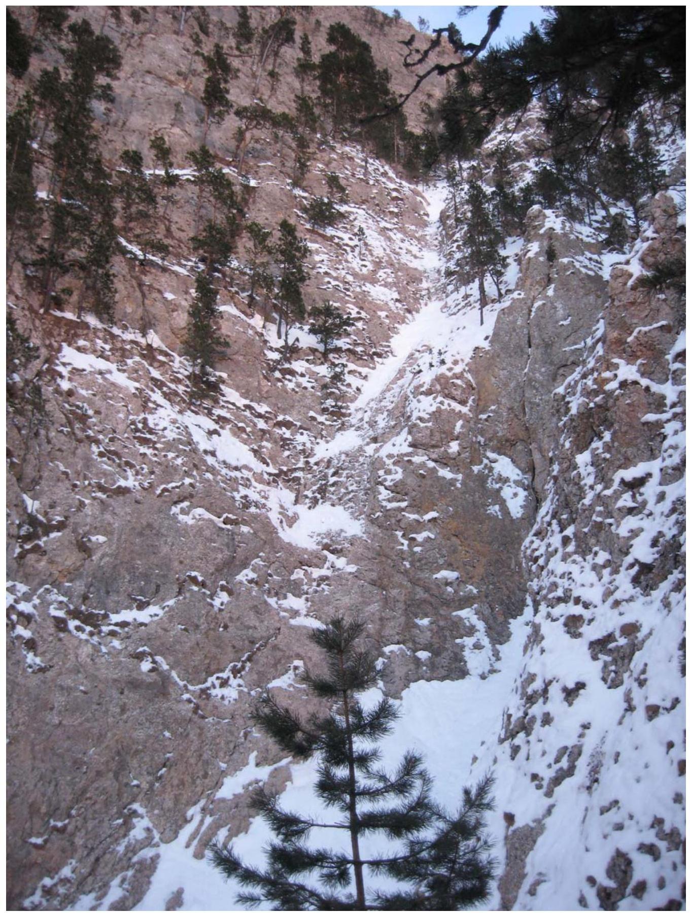
Fig. 4. View of the couloir bypassed on the right.
Route Diagram in UIAA Symbols
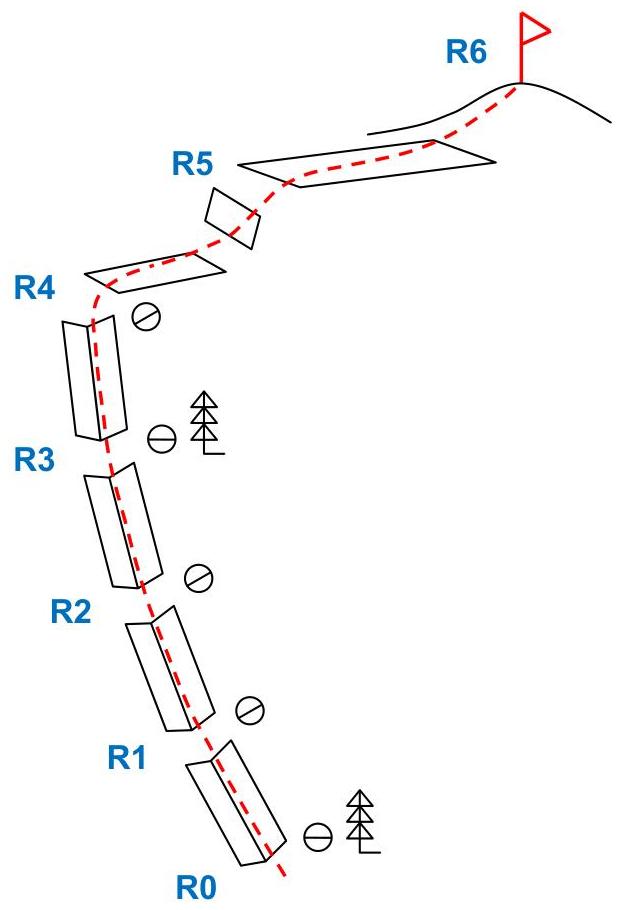
Summary Table of the Route
| Rock, Bolt, Ice Anchors | Friends | Stoppers | Section Number | Category of Difficulty | Length | Steepness |
|---|---|---|---|---|---|---|
| 1 | 2 | 3 | 4 | 5 | 6 | 7 |
| 0 | 0 | 0 | 6 (R5–R6) | 0 | 150 m | 20° |
| 0 | 1 | 1 | 5 (R4–R5) | I–II | 50 m | 30° |
| 0 | 2 | 1 | 4 (R3–R4) | III | 30 m | 60° |
| 0 | 3 | 0 | 3 (R2–R3) | II–III | 30 m | 70° |
| 0 | 2 | 1 | 2 (R1–R2) | II | 30 m | 60° |
| 0 | 0 | 2 | 1 (R0–R1) | I–II | 30 m | 50° |
Route and Descent Description
The route begins at a large pine tree (see Fig. 5), standing at the very start of the internal corner along which the ascent is made. A station is set up on it, and the first section (R0–R1, I–II, 30 m, 50°) begins from it. Upon completion of this section, that is, after approximately 30 m of climbing, sufficiently convenient ledges for feet appear (see Fig. 6). Here, a station needs to be set up.
Further movement occurs along the sections:
- 2nd section (R1–R2, II, 30 m, 60°) — ends with deep cracks in the internal corner. They allow holding onto them with hands and the soles of boots, which is sufficient for organizing a station at this location.
- 3rd section (R2–R3, II–III, 30 m, 70°) — ends with a pine tree on which a station needs to be set up.
- 4th section (R3–R4, III, 30 m, 60°) — ends with the end of the internal corner (see Fig. 7). Here, too, a station needs to be organized.
Overall, the ascents throughout sections 1–4 differ only in a gradual change in the steepness angle, and therefore, all sections simultaneously are key. Or, in other words, it's impossible to single out one key section among them.
Next follow:
- 5th section (R4–R5, I–II, 50 m, 30°) — the route of which passes along a ridge (see Fig. 8). That is, after completing the movement along the internal corner, one needs to make a turn at a right angle to the right and then move straight. At the end of the section, after overcoming a small ascent, there will be an exit to the upper plateau.
- 6th section (R5–R6, 0, 150 m, 20°) — from the upper plateau, gradually ascending (see Fig. 9), one needs to reach the third highest peak of Mt. Bolshoy Tkhach (2161.0 m).
The descent is made along the path of the ascent route and the approach to it, leading to the overnight stay location at the upper camps.
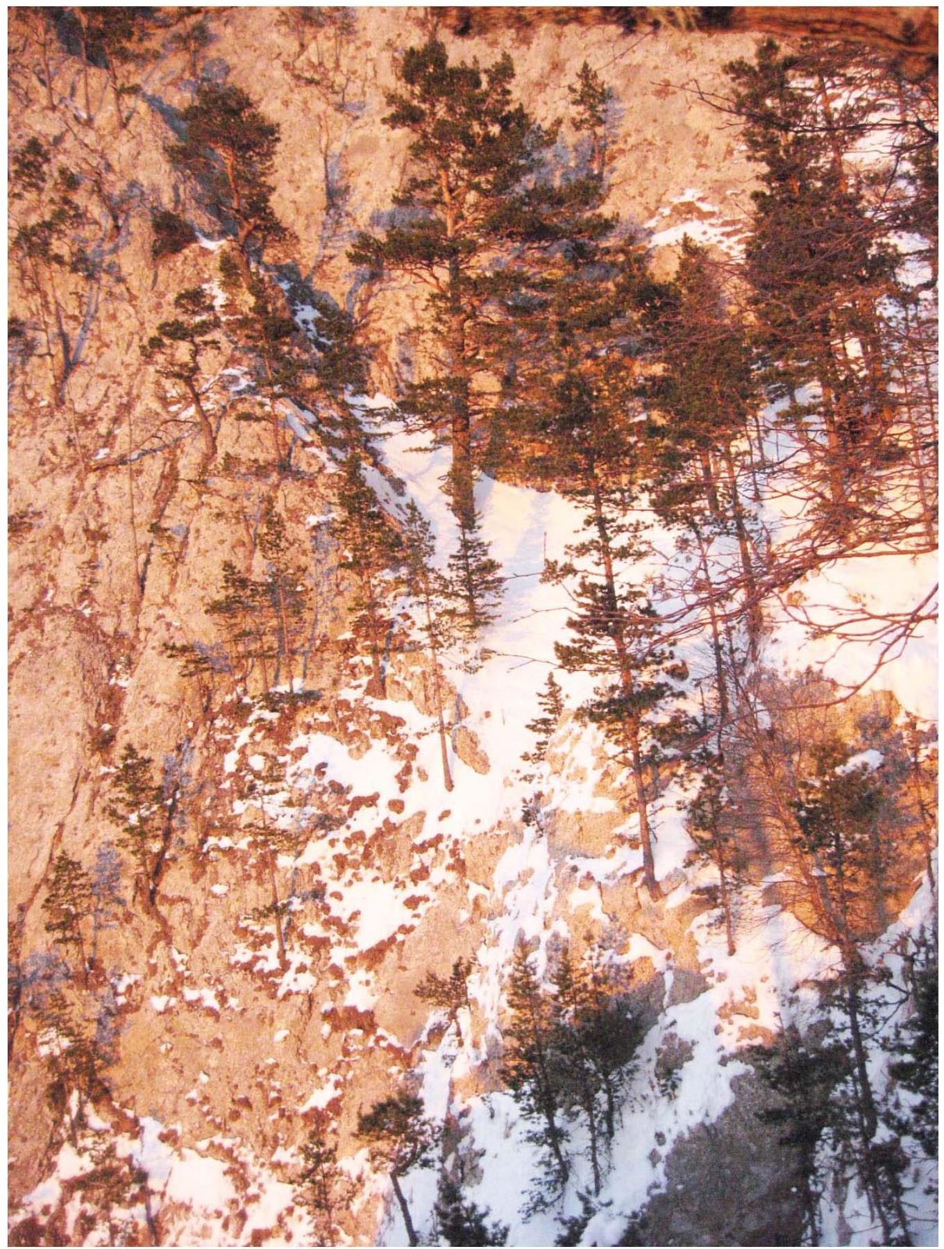
Fig. 5. Section #1 (R0–R1), as well as a view of the upper part of the couloir (the large pine tree from which the route begins is in the center).
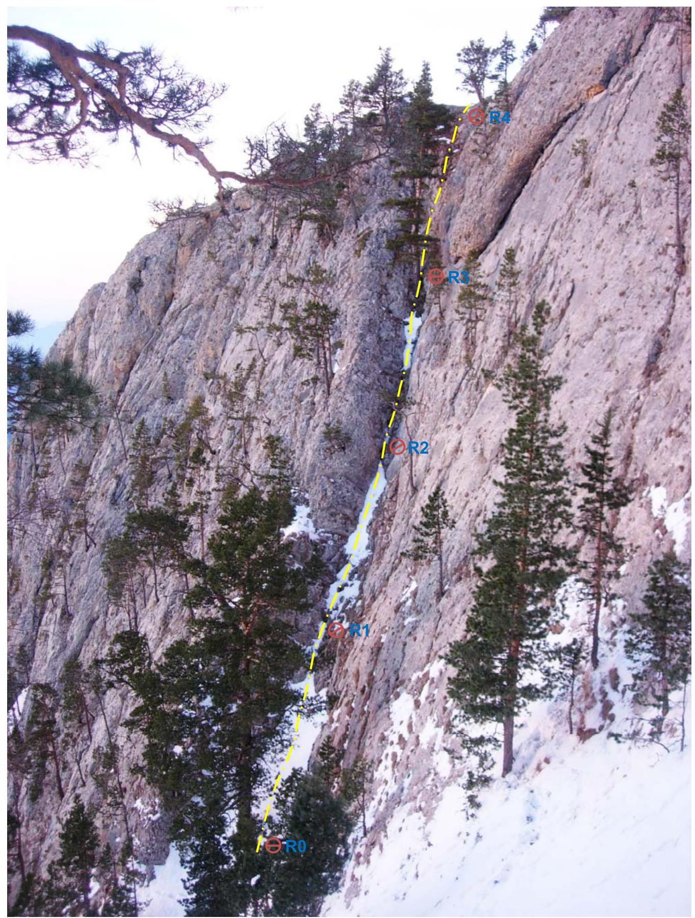
Fig. 6. Sections #1, 2, 3, 4 (R0–R4) and the diagram of movement along them.

Fig. 7. Section #4 (R3–R4), as well as a side view of section #5 (R4–R5).
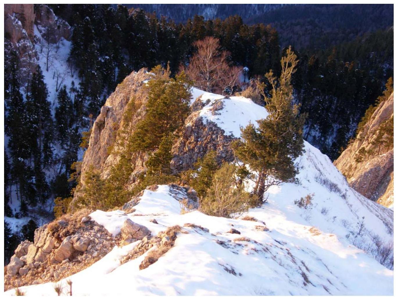
Fig. 8. Section #5 (R4–R5).
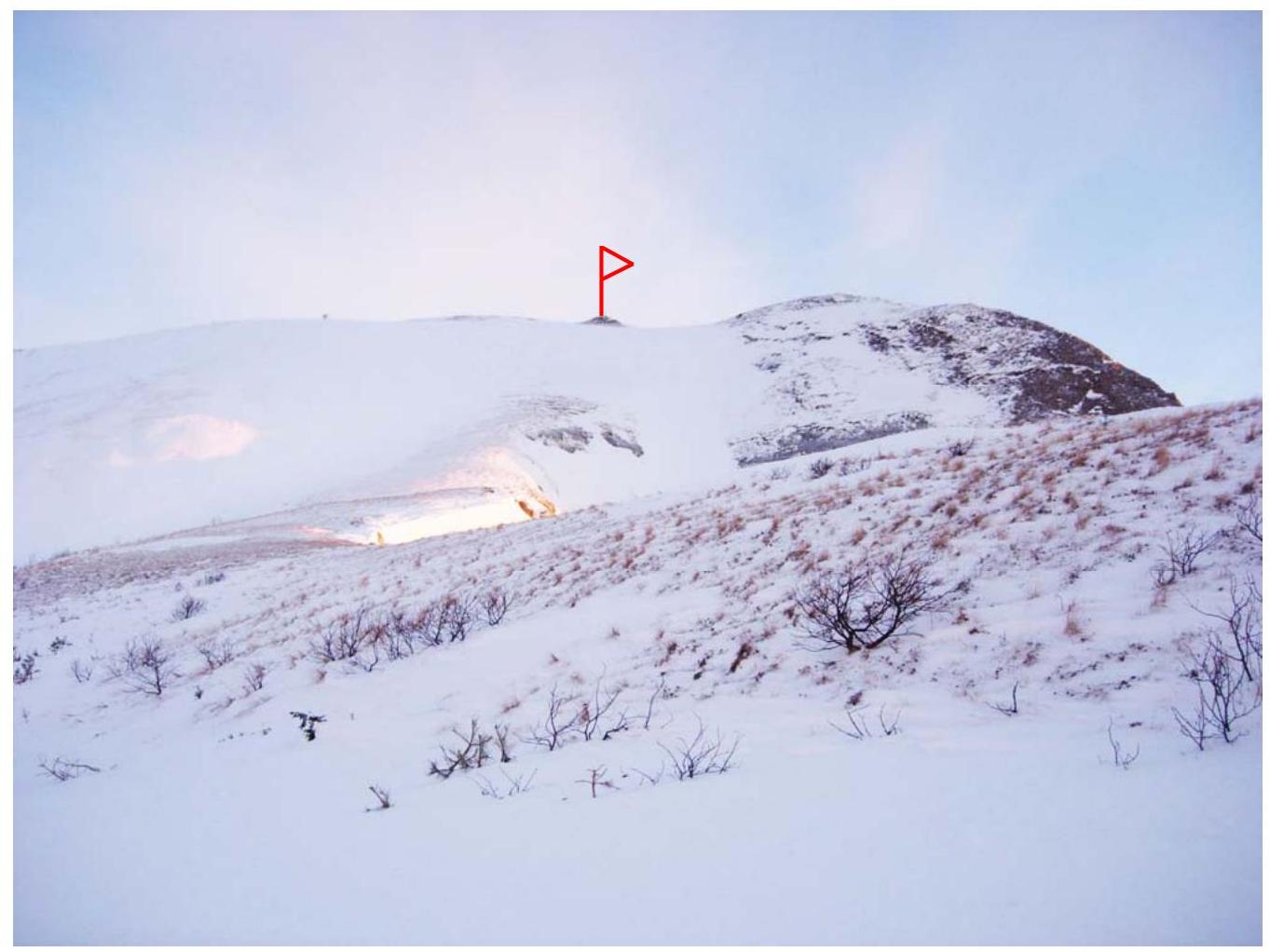
Fig. 9. The third highest peak of Mt. Bolshoy Tkhach (2161.0 m).
General Conclusion on the Route
The "Otkryshka" route along the SW couloir of Mt. Bolshoy Tkhach is a technically interesting route. During the ascent, it is fairly logical and safe for prepared participants. Moreover, the determination of locations for station setup is entirely obvious.
The choice of the route name "Otkryshka" was not made by the first ascent participants by chance. The fact is that after arriving at the lower or upper camps, this route will be the closest to them and, accordingly, the first to be climbed on Mt. Bolshoy Tkhach. Therefore, for preparation for more complex ascents (for example, along the "Novy God" or "Bashnya" routes), this route with an estimated category of difficulty of 2A is recommended for mandatory passage.
It should be noted that the route will be significantly complicated during rain or fog, especially along the entire length of sections R0–R4, as it is somewhat damp in this area even in good weather.
When evaluating the route, the first ascent participants took the following previously climbed routes for comparison:
- Shogentsukova along the S ridge — 2B category of difficulty
- Kurmychi along the 3rd slope of the S ridge — 2B category of difficulty
- Krogzor Myrdy along the S ridge — 2A category of difficulty
- Kullumkol along the NE ridge — 2A category of difficulty
- Viatau along the S ridge — 2A category of difficulty
- Gumachi along the S ridge — 1B category of difficulty
- Merdven-Kaya along the "Syurpriz" route — 1B category of difficulty
Based on the analysis, the group believes that the "Otkryshka" route corresponds to the 2A category of difficulty and can be recommended as a fairly interesting route for sports ascents.
Thus, currently, three routes have been laid out on Mt. Bolshoy Tkhach. Moreover, it should be noted that they allow for ascents to the three highest peaks of Mt. Bolshoy Tkhach (see Fig. 2): the "Otkryshka" route, 2A category of difficulty (2161.0 m); the "Novy God" route, 3A category of difficulty (2246.0 m); the "Bashnya" route, 3B category of difficulty (2368.4 m).
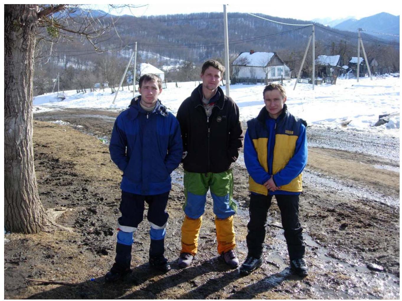
Fig. 10. Participants of the first ascent (from left to right): A.Yu. Burlev, M.V. Bogatyrev, and Yu.A. Menyayev in Novoproxladny settlement (Sakhray), August 7, 2008.
List of Abbreviations Used
cat. diff. — category of difficulty sports cat. — sports category mt. — mountain SW, S, W, NE, N — southwest, south, west, northeast, north ITC — intermediate technical category (likely referring to artificial climbing holds or artificial aids) UIAA — Union Internationale des Associations d'Alpinisme (International Climbing Federation)