
Peak 3226 (Dimitrov-100) Route: via north-west edge Complexity category — 4A cat. sl. (combined) Leader: S. Bernatsky Western Caucasus, Kara-Jash ridge Section in KMGV — 2.1. E-mail — ZHUR58@RAMBLER.RU
Report
On the first ascent of the climbing route to peak 3226 (Dimitrov-100) "Via north-west edge 4A cat. sl. (combined)". At the year-round alpine event "Championship and primacy of NP 'Club of northern travels 'Sauk-Pai' 2011 (class 'First ascents')".
Region: Karachay-Cherkess Republic Mountain country: Western Caucasus Gorge: Orlyonok ravine Ridge: Kara-Jash mountain massif Peak: 3226 (Dimitrov-100) Route: via north-west edge 4A cat. sl. (combined).
Prepared by: Bernatsky S. I., Zhuravlev S. V. May 2011.
Passport
- Section number according to KMGV — 2010 — 2.1. Western Caucasus, mountain region — Arkhyz, Kara-Jash ridge
- Name of the peak: 3226 (Dimitrov-100, Taulan) Height: 3226 m Route: via north-west edge
- Complexity category: 4A cat. sl.
- Route character — combined.
- Height difference of the route: 3226 m
- Route length: 1250 m
- Length of sections with the highest cat. sl.: 1 cat. sl. — 1 section — 300 m, 2 cat. sl. — 6 sections — 920 m, 3 cat. sl. — 3 sections — 95 m, 4 cat. sl. — 2 sections — 45 m, 5 cat. sl. — 0 sections — 0 m, 6 cat. sl. — 0 sections — 0 m.
- Average steepness: main part of the route — 60°, entire route — 50°.
- Pitons used: Total used on the route: rock pitons — 9, chocks — 33, bolt hangers stationary — 0, ITO — 0, bolt hangers removable — 0. Left "pitons" on the route: total — 1; including bolt hangers — 0.
- Departure to the route — 5:00, May 9, 2011 Arrival at the summit — 16:00, May 9, 2011 Return to BL — 20:00, May 9, 2011
- Team's walking hours: — 15 h.
- Leader: Sergey Bernatsky (MS, instructor-methodologist 2nd category, Yekaterinburg). Participants: O. Kolesnikova (2nd sp. category, Syktyvkar), A. Bonchuk (2nd sp. category, Syktyvkar), Vyacheslav Babkin (CMS, instructor-methodologist 3rd category, Yekaterinburg).
- Coach: Zhuravlev Sergey Vasilyevich, title — CMS, instructor-methodologist 1st category.
Description of the peak
Peak 3226 is one of the peaks in the northern part of the Kara-Jash ridge. It is located on the territory of the Caucasus Federal District of the Russian Federation, in the Karachay-Cherkess Republic, Arkhyz mountain region, between the Psyish and Sofia rivers. Peak 3226 is a prominent mountain of the Kara-Jash ridge, located to the northwest of the nodal peak Kara-Jash (3171). The peak is easily identifiable from the upper cirque of the Orlyonok ravine. Officially, the peak has no name, so it has conditional tourist-climbing names:
- Tourist — Taulan
- Climbing — Dimitrov-100 which introduces some confusion when identifying the peak.
Description of the route
The route "Via north-west edge" is a characteristic sports combined route of 4A cat. sl., with a full set of natural obstacles corresponding to routes of this level.
Equipment
To complete the ascent as part of a sports group of 4 people on the route, the following special equipment is necessary:
- Personal: standard, crampons, ice axe
- Group:
- main rope 10 mm — 2 × 50 m
- rock hammer — 2 pcs.
- rock pitons — 16 pcs.
- ice axe — 1 pc.
- chock elements — 12 pcs.
- cams — 6 pcs.
- ice screws — 0 pcs.
- quickdraws — 16 pcs.
- slings — 10 pcs.
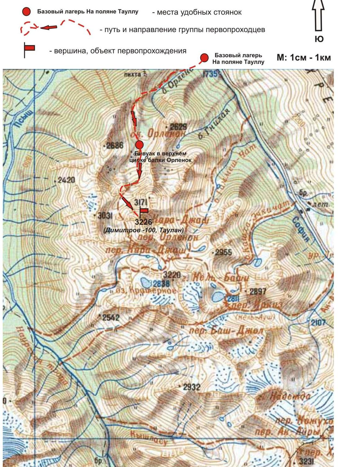
Approach
The ascent is made from a bivouac in the upper cirque of the Orlyonok ravine. Approach to the upper cirque:
- Cross the Sofia River by bridge from Taullu clearing
- Ascend the Orlyonok ravine — first along a logging road, then along a clearly visible trail
The cirque is well-defined:
- In winter and spring off-season — snowy
- In summer — overgrown with alpine vegetation, with two beautiful lakes among small birch and pine groves
The height of the cirque above sea level is 2200 m. The ascent from Taulu clearing to the cirque takes 1.5–2 hours. In the cirque, there are convenient places for tents, with water (streams) and dry areas, free from snow from the end of April to the beginning of May. In the panorama of the cirque, peak 3226 is easily identifiable. The approach from the campsite to the start of the route — the rock block "Oreх" — takes about one and a half hours. The rock block "Oreх", located in the couloir separating peak Kara-Jash and peak 3226, is easily identifiable at any time of the year.
Technical part
The route begins with an ascent along a snowy slope to the rock block "Oreх". On the rock block "Oрех" — a platform allowing the organization of teams. Then — an oblique traverse to an oblique ledge leading to the rocky crest of the north-west edge. Direction is kept towards the prominent gendarme "Ptitsa". From gendarme "Ptitsa" movement does not cause difficulty in orientation, as it follows strictly along the line of the rocky crest. Route cruxes:
- The first — minor crux — the second rocky wall between gendarmes "Ptitsa" and "Centralny". A convenient turnaround point in case of sudden changes in weather or insufficient level of preparedness of the ascent participants.
- The second — main crux — ascent to the pre-summit rocky shoulder. A section of complex technical climbing, requiring from the ascent participants not only skills in passing complex rocky sections in crampons but also skills in competent organization of belays and self-belay on rocky terrain. Rockfall hazard is subjective. In the off-season, there may be verglas on the rocks. The summit is peak-shaped, clearly defined. A note from a sports group from Nevinnomyssk, who made an ascent to the summit via a 3A cat. sl. route, was found.
Descent from the summit
Descent from the summit is made in the direction north to a snowy saddle, then — along a wide couloir separating peaks 3226 (Dimitrov-100, Taulan) and 3206 (Bolgarskikh druzey, Bolgarsko-Sovetskoy druzhby) — to the upper cirque of the Orlyonok ravine.
Fragment of the map (Arkhyz) of the ascent area.
Additional conventional signs
Base camp on Taullu clearing — places of convenient campsites — path and direction of the first ascent team peak, object of first ascent Base camp On Taullu clearing Scale: 1 cm – 1 km
 Scheme in UIAA symbols
Peak: 3226. Route: via north-west edge. Complexity level: 4A cat. sl. (combined)
Scheme in UIAA symbols
Peak: 3226. Route: via north-west edge. Complexity level: 4A cat. sl. (combined)
Section R0–R1. Approach to the "Orex" rock — the place of organizing teams. Snowy slope. Length — 500 m, steepness — 30°, complexity level 2. Simultaneous movement, self-belay with an ice axe. Pitons and chocks were not used.
Section R1–R2. Ascent to the rocky crest of the north-west edge. Snowy slope. Length — 100 m, steepness — 50°, complexity level 2. Oblique rocky ledge. Length — 30 m, steepness — 25°, complexity level 2. Simultaneous movement on a shortened rope. Distinctive landmark — gendarme "Ptitsa". Pitons and chocks were not used.
Section R2–R3. Ascent along the rocky crest under a series of walls. Rocks. Jagged crest.
- Length — 20 m
- Steepness — 50°
- Complexity level — 3
- Movement with alternate belay
- Used (left): pitons — 2/0 pcs., chocks — 4/0 pcs.
Section R3–R4. Passage of the first rocky wall. Monolithic rocks. Inclined wall.
- Length — 20 m
- Steepness — 60°
- Complexity level — 4 Movement with alternate belay, interaction of teams. Used/left:
- Pitons — 0/0 pcs.
- Chocks — 4/0 pcs.
Section R4–R5. Passage of the second rocky wall (minor crux — recommended turnaround point in case of bad weather or technical unpreparedness of the group). Monolithic rocks. Rocky wall.
- Length — 25 m
- Steepness — 60°
- Complexity level — 4 Movement with alternate belay, interaction of teams. Used/left:
- Pitons — 2/0 pcs.
- Chocks — 5/0 pcs.
Section R5–R6. Approach along the crest under gendarme "Centralny". Jagged rocky crest.
- Length — 40 m
- Steepness — 30°
- Complexity level — 2 Simultaneous movement, on a shortened rope, belay with slings on outcrops. Pitons and chocks were not used.
Section R6–R7. Bypass of gendarme "Centralny" along an oblique slab (to the right). Smooth inclined slab, traverse. Section length — 50 m, steepness — 50°, complexity level 3. Movement with alternate belay, handrail. Used (left):
- pitons — 1/1 pcs.
- chocks — 8/0 pcs.
Section R7–R8. Approach along the destroyed rocky crest to the route crux. Destroyed rocks. Crest. Section length — 150 m. Steepness — 15–20°, complexity level — 2. Simultaneous movement, on a shortened rope. Organization of belay for outcrops of the crest. Pitons and chocks were not used.
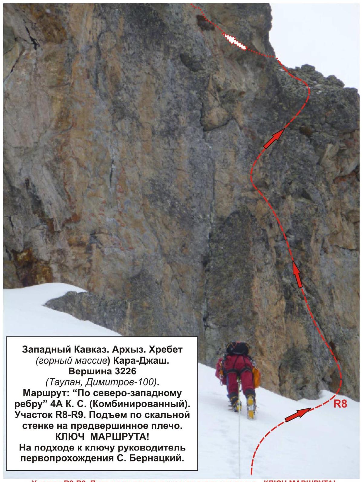
Section R8–R9. Ascent to the pre-summit rocky shoulder — ROUTE CRUX! Two smooth technically complex crest walls.
- First wall: Length — 25 m, steepness — 45°, complexity level — 3
- Second wall: Length — 20 m, steepness — 50°, complexity level — 4 Movement with alternate belay, handrail. Used/left: pitons — 4/0 pcs., chocks — 12/0 pcs.
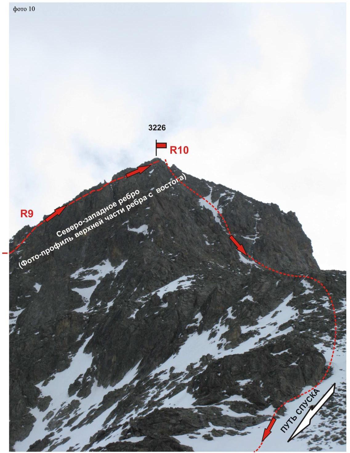
Section R9–R10. Ascent along the pre-summit crest to peak 3226. Destroyed rocky crest.
- Length — 300 m
- Steepness — 20°
- Complexity level — 1 Simultaneous movement. Pitons and chocks were not used.
Photo 10. Peak: 3226. Summit tower. Route: Via north-west edge. Complexity level: 4A cat. sl. (combined). Section R9–R10. First ascent by S. Bernatsky+5 (May 2011).

Photo #1. Western Caucasus, Arkhyz. Kara-Jash ridge. Peak: 3226 (Dimitrov-100, Taulan). Route: via north-west edge. Complexity level: 4A cat. sl. (combined).

Photo #2. Peak Kara-Jash 3137.0. Western Caucasus, Arkhyz. Kara-Jash ridge. Peak 3226 (Dimitrov-100, Taulan). Route: "Via north-west edge" 4A cat. sl. (combined). First ascent: S. Bernatsky+3 (May 2011). Profile of the route from the northeast, from the upper cirque of the Orlyonok ravine.
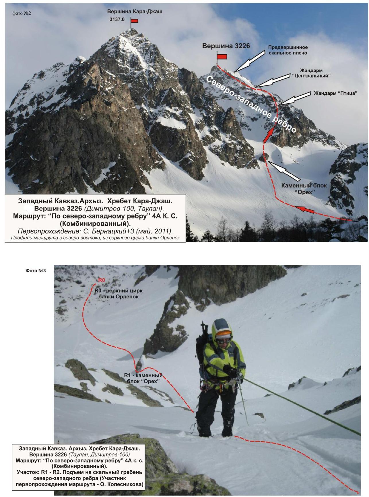
Photo #4. Western Caucasus, Arkhyz. Kara-Jash ridge. Peak 3226. Route: "Via north-west edge" 4A cat. sl. (combined). Section R1–R2 — ascent to the rocky crest of the north-west edge. Distinctive landmark — gendarme "Ptitsa".
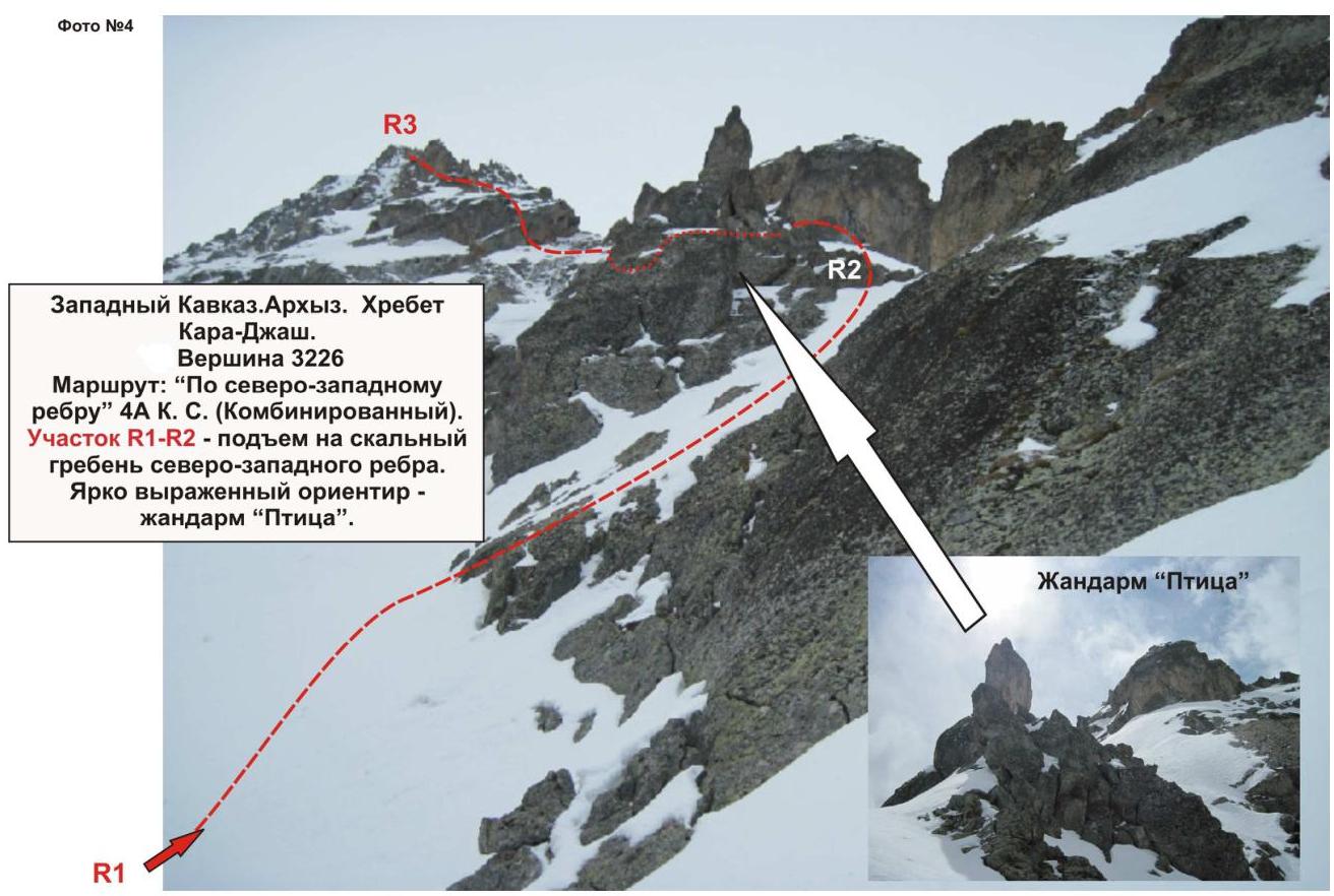
Photo #5. Section R4–R5. Passage of the second rocky wall (minor crux — recommended turnaround point in case of bad weather with the group leader S. Bernatsky).
Photo #6. Western Caucasus, Arkhyz. Kara-Jash ridge. Peak 3226 (Taulan, Dimitrov-100). Route: "Via north-west edge" 4A cat. sl. (combined). Section: R5–R6. Passage of the crest and approach under gendarme "Centralny".
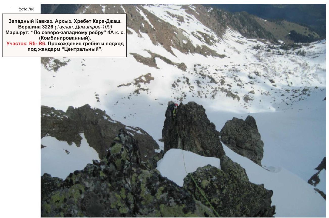

Photo #7. Section R6–R7. Bypass of gendarme "Centralny" along an oblique slab (to the right). Smooth inclined slab, traverse. Section length — 50 m, steepness — 50°, complexity level 3. Movement with alternate belay, handrail. Used/left: pitons — 1/1 pcs., chocks — 8/0 pcs.
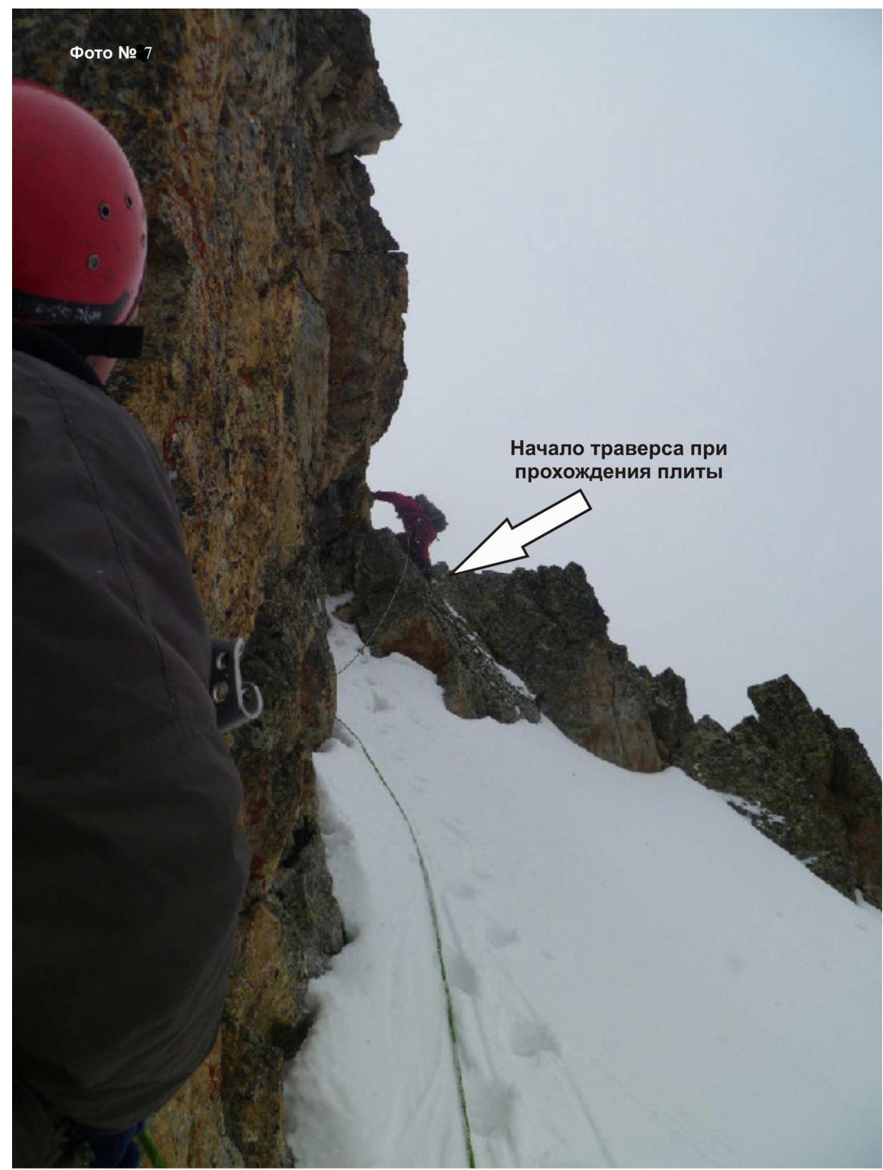
Photo #8. Western Caucasus, Arkhyz. Kara-Jash ridge (mountain massif). Peak 3226 (Taulan, Dimitrov-100). Route: "Via north-west edge" 4A cat. sl. (combined). Section R8–R9. Ascent along the rocky wall to the pre-summit shoulder. ROUTE CRUX! Leader of the first ascent S. Bernatsky is approaching the crux.
 Section R8–R9. Ascent to the pre-summit rocky shoulder — ROUTE CRUX! Two smooth technically complex crest walls. First wall: Length — 25 m, steepness — 65°, complexity level 4. Second wall: Length — 20 m, steepness — 65°, complexity level 4. Movement with alternate belay, handrail. Used/left: pitons — 4/0 pcs., chocks — 12/0 pcs.
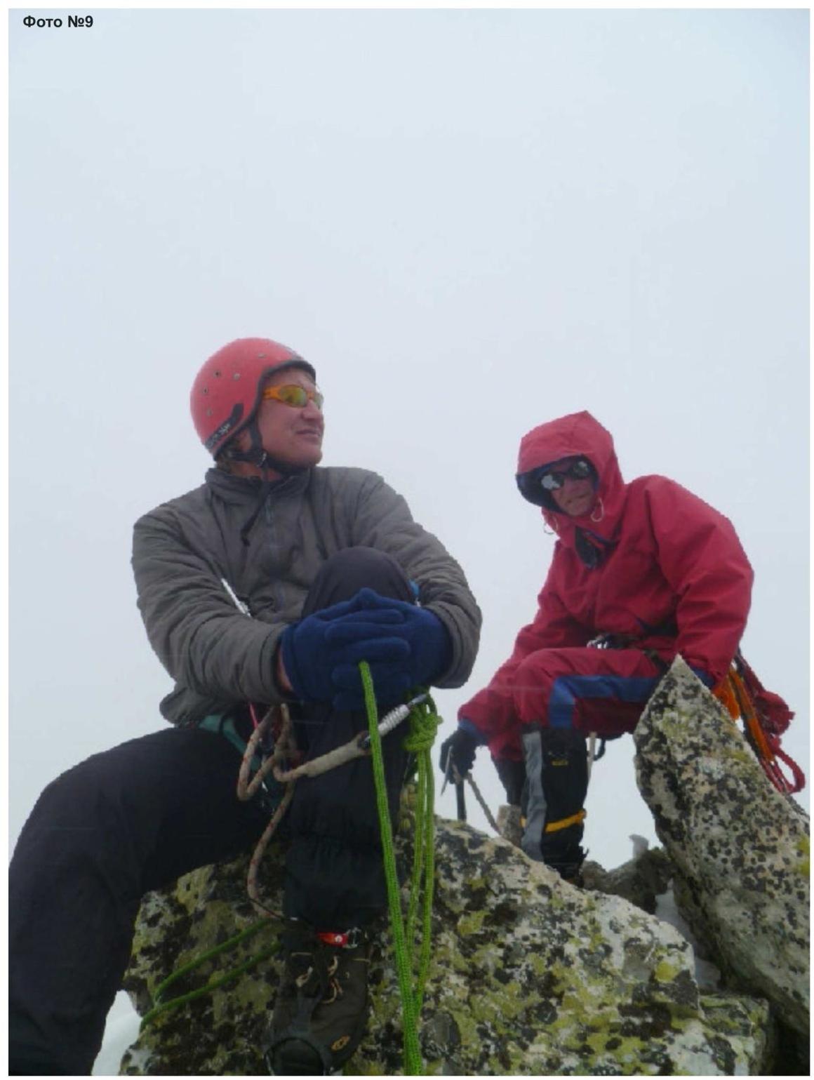
Photo #9. Western Caucasus, Arkhyz. Kara-Jash ridge (mountain massif). Peak 3226 (Taulan, Dimitrov-100). Route: "Via north-west edge" 4A cat. sl. (combined). At the summit, leader of the first ascent S. Bernatsky and participant V. Babkin. (Photo by O. Kolesnikova)
Comments
Sign in to leave a comment