
Peak 3226.0 (Dimitrov-100, Taulan)
Route: via the western couloir and southern ridge
Complexity category — 2B cat. sl. (combined)
Leader: S. Bernatsky
Western Caucasus, Arkhyz, Orlenok gully, Kara-Jash mountain range
Section in KMGV — 2.1.
E-mail — ZHUR58@RAMBLER.RU
Report
On the first ascent of the climbing route to peak 3226.0 (Dimitrov-100, Taulan) "Via the western couloir and southern ridge 2B cat. sl. (combined)". At the climbing competitions "Cup of Victory" by NP "Club of Northern Travels 'Sauk-Pai'" (class "First Ascents") in May 2013.
Region: Karachay-Cherkess Republic Mountain country: Western Caucasus Gully: Orlenok gully Ridge: Kara-Jash mountain range Peak: 3226.0 (Dimitrov-100, Taulan) Route: via the western couloir and southern ridge. Level of complexity: 2B cat. sl. (combined) (approximately)
Prepared by:
- S. Bernatsky
- S. Zhuravlev May, 2013
Description of the peak
Peak 3226.0 is one of the peaks in the northern part of the Kara-Jash ridge. It is located on the territory of the North Caucasian Federal District of the Russian Federation, in the Karachay-Cherkess Republic, in the Arkhyz mountain region, between the Psyish and Sofia rivers.
Peak 3226.0 is a pronounced mountain of the Kara-Jash mountain range, located northwest of the nodal peak Kara-Jash (3171.0). The peak is easily identifiable from the upper cirque of the Orlenok gully. The peak does not have an official name, so it has conditional tourist and climbing names:
- Tourist name — Taulan
- Climbing name — "Dimitrov-100"
which creates some confusion when identifying the peak.
Description of the route
The route "Via the western couloir and southern ridge" is a typical sports combined route of 2B cat. sl., with a full range of natural obstacles corresponding to routes of this level.
Equipment
To complete the ascent, a sports team of 4 people will need the following special equipment on the route:
Personal:
- standard
- crampons
- ice axe
Group:
- main rope 10 mm — 2×50
- hammer sk. — 2 pcs.
- pitons sk. — 16 pcs.
- ice axe — 1 pc.
- protection elements — 12 pcs.
- friends — 6 pcs.
- ice screws — 0 pcs.
- quickdraws — 16 pcs.
- slings — 10 pcs.
Approach
The ascent is made from a bivouac in the lower cirque of the Orlenok gully.
Approach to the lower cirque: from the Taulu glade, cross the Sofia River by bridge and ascend along the Orlenok gully — first along a logging road, then along a well-traced trail.
The cirque is pronounced:
- in winter and spring off-season — snowy,
- in summer — overgrown with high-altitude vegetation.
The height of the cirque above sea level is 1600 m. The ascent from the Taulu glade to the cirque takes 1.5–2 hours.
In the lower cirque of the Orlenok gully, there are convenient places for tents with:
- water (streams),
- firewood,
- dry areas, freed from snow in late April — early May.
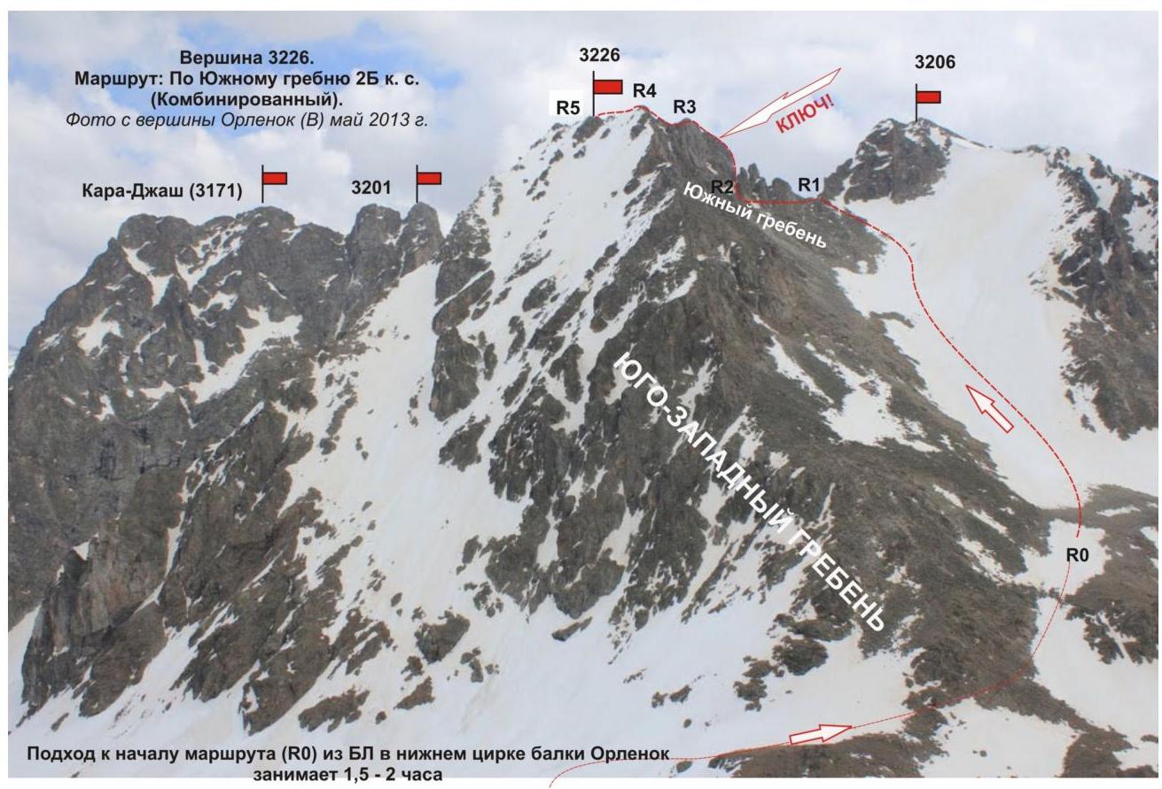
Approach to the start of the route: from the base camp in the lower cirque of the Orlenok gully, ascend along the trail leading to the Orlenok pass. In the panorama of the cirque, peak 3226.0 (Taulan, "Dimitrov-100") is easily identifiable — to the right of Kara-Jash, the nodal peak of the Orlenok gully. Pass under the western slopes of the peak and exit to a scree island in the lower part of the couloir, leading to the saddle between peaks 3226 (Taulan, "Dimitrov-100") and 3206 (BSD). The approach from the campsite in the lower cirque of the Orlenok gully to the start of the route — the base of the couloir leading to the saddle between peaks 3226 and 3206 — takes about 1.5–2 hours.
Technical part
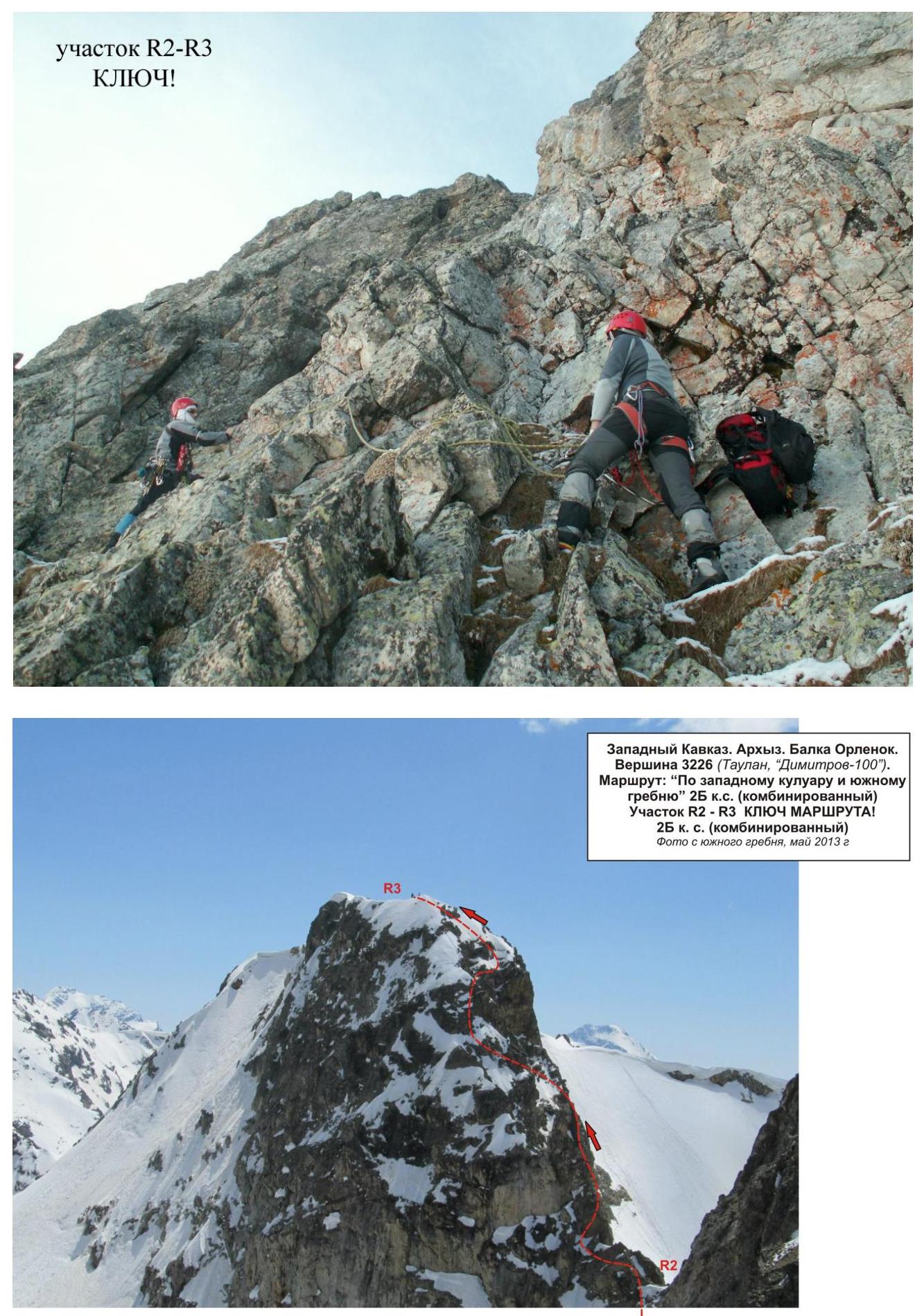
The route begins with an ascent up the snowy couloir to the saddle. On the saddle, there is a convenient place to organize rope teams. Then, traverse left along the ledges to bypass the gendarme. After the gendarme, there is a complex ridge wall — this is the key part of the route.
The key part of the route — a rocky wall — is a monolith. In the upper part, the climbing becomes more complicated, requiring increased attention. Rockfall danger is subjective. In the off-season, there may be ice on the rocks.
After passing the key section of the ridge, there is an exit to a rocky ridge of medium complexity and movement along it on a shortened rope with rope protection. The ridge becomes gentler towards the peak.
The peak is pronounced. A cairn is easily found. Descent from the peak: descent is made via the ascent route.
Recommendations for instructors
Due to the accessibility of the route for orientation, it can be recommended for both training sports teams (NP-2) and independent sports groups of skilled climbers making guided or training ascents.
Time required to complete the route for a training sports team of average skill level (NP-2) — 8–10 hours.
Western Caucasus, Arkhyz, Orlenok gully, peak 3226.0 ("Dimitrov-100", Taulan). Route: "Via the western couloir and southern ridge" 2B (combined) (approximately)
(table of natural obstacles on the route)
| Section | Length | Steepness | Character of relief | Cat. sl. | Number of pitons/protection |
|---|---|---|---|---|---|
| R0 — entrance to the couloir leading to the saddle between peaks 3226 and 3206. | On a scree rocky island, a convenient place to organize rope teams | ||||
| R0–R1 Ascent up the snowy slope to the saddle | 300 | 25-35 | S/l slope | 1 | 0 / 0 |
| R1–R2 Traverse of the gendarme along the ledges (leftwards) | 100 | 35 | Rocky ledges | 2 | 0 / 0 |
| R2–R3 Passage of the wall and exit to a rocky shoulder. KEY PART OF THE ROUTE! | 35 | 60 | Rocky wall | 3+ | 2 / 4 |
| R3–R4 Passage along the rocky shoulder and exit to the pre-summit ridge. | 50 | 30 | Rocky ridge | 2 | |
| R4–R5 Passage along the rocky ridge and exit to the peak | 135 | 40 | Rocky ridge | 2+ | 0 / 0 |
| R5 — peak 3226.0 ("Dimitrov-100", Taulan) | Pronounced. Cairn easily found. | ||||
| Descent | Via the ascent route |
Total
Route length — 625 m. Average steepness — 4°. Character of relief — combined
Sections:
- 1 cat. sl. — 1 section — 300 m
- 2 cat. sl. — 3 sections — 285 m
- 3 cat. sl. — 1 section — 35 m
- 4 cat. sl. — 1 section — 5 m
Pitons and protection used: 2/4. Pitons and protection left: 0/0.
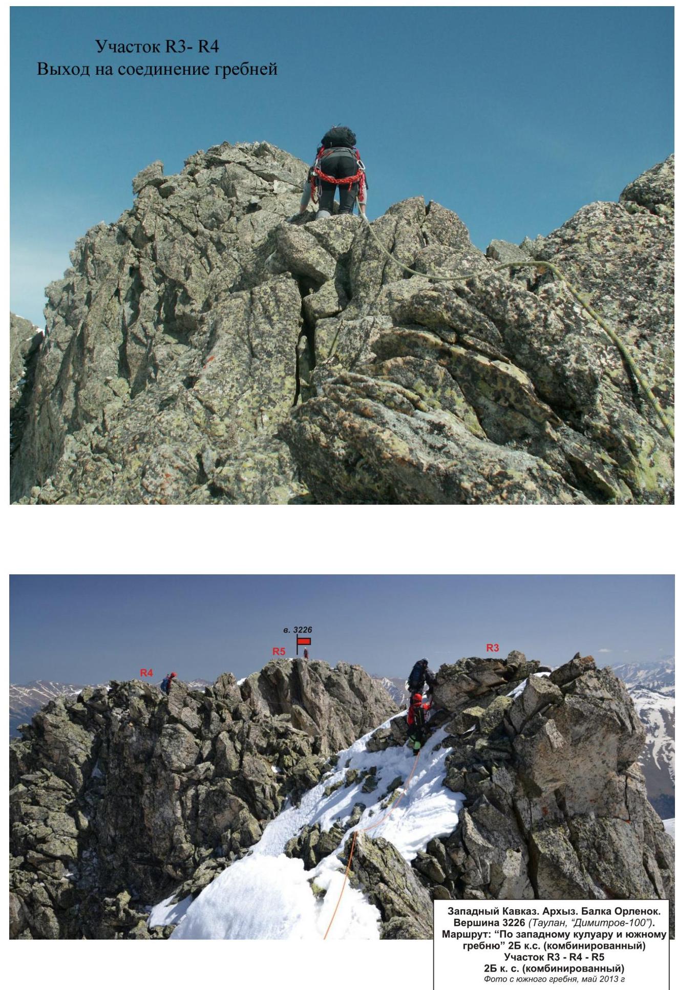
Western Caucasus. Arkhyz. Orlenok gully. Peak 3226 (Taulan, "Dimitrov-100").
Route: "Via the western couloir and southern ridge" 2B cat. sl. (combined)
Section R3–R5 2B cat. sl. (combined)
Photo from the southern ridge, May 2013.
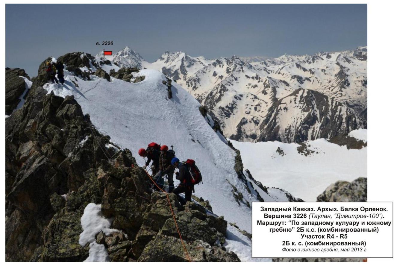
Western Caucasus. Arkhyz. Orlenok gully. Peak 3226 (Taulan, "Dimitrov-100").
Route: "Via the western couloir and southern ridge" 2B cat. sl. (combined)
Section R4–R5 2B cat. sl. (combined)
Photo from the southern ridge, May 2013.
Comments
Sign in to leave a comment