41
Description
The first ascent of an unnamed peak with the goal of naming it "Столетие освобождения Болгарии" (Bulgaria's Liberation Centennial), via the "islands" from the north and the western ridge, approximately category 3B complexity.
From the base camp, follow the trail used by Kislovodsk residents to Sofia Glacier, exiting under the northern slopes of peak Столетие освобождения Болгарии, located east of Sofia peak — 4 hours.
The route passes through four rocky "islands" on the northern slope of the ridge connecting these two peaks.
Crossing the glacier, we approach the I rocky "island". Before it lies a 5-meter-wide bergschrund, which is overcome by descending onto a snow bridge that leads to the rocks. The ascent begins with a 30-meter wall at 70–75°. Climbing is moderately difficult, with piton protection.
After the I rocky island, a 30-meter snow-ice slope at 45–50° leads to the II rocky "island". It is climbed to the left, as the rocks on the right are covered in glaze ice. The rocks are moderately difficult, with piton protection. In some places, there is glaze ice that does not hinder progress. The length of the II rocky island is 70 meters. At the midpoint of the island is the I control cairn!
Before exiting onto the snow, there are 20 meters of gentle rocks. Then, a 40-meter snow slope at 40–45° leads to the III rocky "island".
The third rocky "island" is climbed straight up. Its length is 100 meters. The rocks are easy. After the III rocky "island", there is about 100 meters of a steep snow slope. In the lower part, the slope is 50°, and in the upper part, it is 55°. This snow slope leads under the IV rocky "island".
The fourth rocky "island" begins with a 5-meter step, followed by 15 meters of a steep (55°) snow slope, then a second step of about 10 meters of steep rocks (difficult climbing). Further on, there are 30 meters of easy rocks, forming steps, with an overall steepness of 60°.
After passing the rocks, there is a 150-meter snow slope at 50–55°, which is overcome by moving to the left and upwards under the rocks of the ridge. Protection is alternating, using an ice axe.
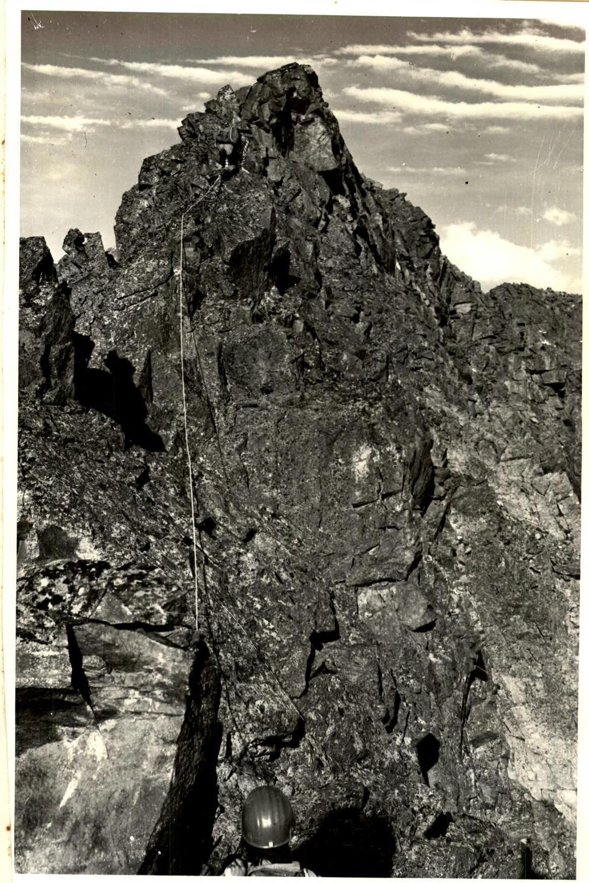
The first 30 meters of rocks are easy, with steps. This section is heavily snowed under. Further on, there are 30 meters of steep, difficult rocks — average steepness 80°. Climbing is challenging, with piton protection. Then the rocks become less steep, at 70°. Along the way, there are many solid ledges convenient for organizing protection and self-protection. The last 10 meters before reaching the ridge is a slab at 60°. The total length of these rocks is 120 meters. The route leads directly under the ascent of the western ridge of the peak. On the ridge, there is the II control cairn, located on a platform under the ascent. Bivouac is possible. Elevation 3250 meters.
Movement along the western ridge is carried out with simultaneous protection on the entire rope, as the sharp ridge does not allow for other movement. We reached the ridge at 14:30. Simultaneous movement continues until the first "gendarme", which is overcome directly "head-on". After the "gendarme", there is a 20-meter rappel.
The ascent to the II "gendarme" is via a 30-meter wall. The wall is solid, with moderately difficult climbing. The wall's steepness is 65–70°. The "gendarme" is sharp and peak-like. Descent from it is down a 10-meter sheer wall with good handholds, using free climbing.
Further along the ridge, there are three more sharp, steep, peak-like "gendarmes" with difficult climbing and sheer descents of up to 10 meters. After them, there is an exit onto the sharp pre-summit ridge, leading to the summit.
We reached the summit at 17:00. The summit elevation is 3410 meters. The group took 8 hours to ascend from the glacier to the summit.
The descent from the summit was made via:
- the easy eastern ridge;
- snowfields on the northern slope;
- small rocky outcrops;
- the bergschrund onto Sofia Glacier.
The descent to the glacier took 1.5 hours.
The total time for the ascent was 16 hours. During the ascent, 26 pitons were hammered in, including three for rappelling.
Recommendations: To complete this route, the following equipment is necessary:
- main rope — 2 × 30 meters
- ice axes — 4 pieces
- crampons — 2 pairs
- pitons — 17–20 pieces
- carabiners — 25 pieces
- hammers — 2 pieces
- ice screws — 2 pieces
- tent — 1 piece
- "Shmel" primus stove — one
- first-aid kit
Ascent to the II "gendarme".