Description of the ascent to peak Smidovich via the western counterfort
Group composition
1. Kovalevsky V.A. — II category — leader 2. Shklyaev E.V. — II category — participant 3. Kovalenko Yu.I. — II category — participant 4. Smoglyukov S.E. — II category — participant
First day (approach to the route) May 4, 1973
Departure from the base camp to lake KARDYVACH at 4:00 AM, upstream along the right bank (in the direction of travel) of the VERKHNYAYA MZYMTA river to a group of large boulders under the slopes of peak LAUB EASTERN.
Then, upwards to the right along a wide snowy slope with rocky outcrops, exit to a shoulder under peak Severnaya Tsyndyshko (3–3.5 hours from the base camp to the shoulder). From the shoulder, leftwards to a sharp depression in the southwestern ridge of peak SMIDOVICH; CHERNORECHENSKY pass (1 hour).
From the pass, descent along a steep snowy slope to the first rocky terrace near peak SMIDOVICH (1.5 hours descent).
From the first rocky terrace:
- ascent to the left, clearly visible rocky shoulder of the second rocky terrace (1 hour ascent)
- on the shoulder, a convenient area for an overnight stay
From the area:
- the beginning of the route is visible
- observation of the route was conducted
- the approach path to the start of the route was examined
In the evening, this part of the path was prepared; steps were trodden.
Second day. May 5, 1973
From the initial bivouac on the rocky terrace, along a 40–45° snowy slope, bypassing rocky outcrops on the right at about half the distance on the slope, we approach the base of a pronounced "Finger" gendarme at the start of the route. The length of this section is 450 m; time taken to traverse it is 2 hours.
R0–R1. Passing the "Finger" gendarme on the right along the snow and then leftwards along a snow-covered internal angle, we ascend to the shoulder of the counterfort. In the upper part of the internal angle, ascent is along the left wall. On the shoulder is the 1st control cairn. From the shoulder, moderate climbing along the ridge to the rise of the first wall. From here, along rocks of medium difficulty, upwards to the right under an overhanging wall (2 m). The length of this section is 90 m; time taken is 1 hour 30 minutes. Belaying through protrusions and pitons. 2 pitons driven. Steepness 50°.
R1–R2. From under the overhanging wall, leftwards along a cleft, then upwards to the ridge of the counterfort along difficult rocks — 7 m. Further along the right side of the counterfort ridge, we pass a 2-meter wall with an exit to an inclined ledge with loose rocks. From here, traverse rightwards — 2 m and exit along difficult rocks (5 m) to a snow-covered ledge leading leftwards upwards to the ridge of the counterfort under a vertical crack, limited above by rocky fins. The length of this section is 35 m; time taken is 1 hour 30 minutes. 7 pitons driven, 1 ice axe used as a rock piton. Average steepness 75°.
R2–R3. Bypassing the crack, along rocks of medium difficulty upwards to a 4-meter internal angle. The internal angle is traversed with complex climbing, exiting to a 3-meter wall that is climbed directly upwards, leading to a 20-meter snow-covered slab, which is traversed centrally and exits under a 10-meter bastion. Upon exiting to the slab, a ladder is used. Bypassing a 1.5-meter rocky finger, descent — 2 m to a convenient ledge on the right side of the counterfort. The length of this section is 40 m; time taken is 2 hours. 5 pitons driven. Steepness 70°.
R3–R4. Along the right side of a steep 15-meter couloir (pitons used for belaying), we bypass the bastion on the left. In the upper part, we cross the couloir leftwards and along difficult rocks, upwards to the right, exit to a gentle rocky ridge. Along the ridge, we exit to the 2nd shoulder of the counterfort — a control cairn. The length of this section is 100 m; time taken is 1 hour 40 minutes. 5 pitons driven. Steepness 55–60°.
R4–R5. From the shoulder, along a steep snowy slope with rocky outcrops, we move towards a rocky tower limiting the start of the ridge. From the first rocky outcrop, rightwards along the snow to the rocks at the base. The rocky tower is traversed directly upwards along destroyed rocks with further exit to the ridge of the counterfort. The length of this section is 55 m; time taken is 1 hour. 6 pitons driven. Steepness 45–50°.
R5–R6. Further movement along the ridge; alternating sections of snow and rocks. Movement is partly simultaneous until the rise of the ridge. Passing the rise, first leftwards along steep snow for 20 m, then exit to the ridge. Belaying through protrusions and pitons. Further along the flattening part of the ridge — exit to a sharp rocky ridge with steep snow on the left. 40 m before the tower's summit — overnight stay. The length of this section is 200 m; time taken is 1 hour 30 minutes. 3 pitons driven. Steepness 40°. Total distance covered for the day is 520 m. 29 pitons driven.
Third day. May 6, 1973
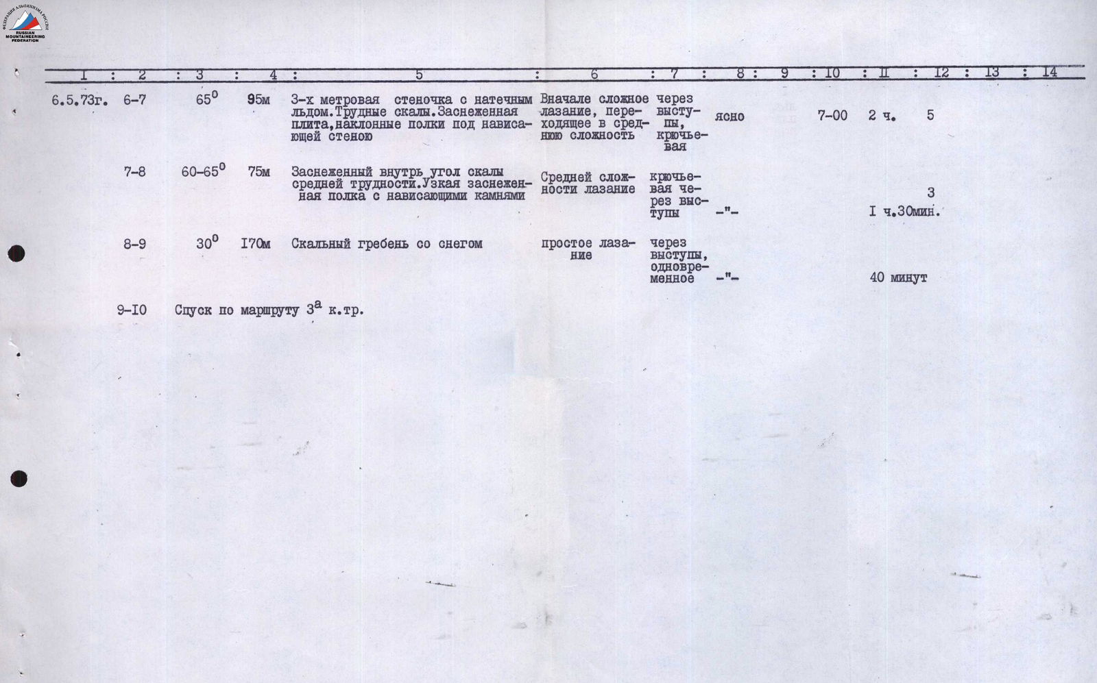
R6–R7. From the overnight stay — a straightforward path to a sharp snowy ridge (cornices!). At the base of the summit tower, ascent begins: first — a 3-meter vertical wall with rimed ice, then — along a slab with a 50° slope with loose rocks leftwards, under a sheer monolithic wall (15 m), then rightwards upwards along the wall to a ledge under an overhang, left of a narrow couloir filled with rimed ice.
- Length of this section: 95 m
- Steepness: 65°
- 5 rock pitons driven
- Time taken: 2 hours
R7–R8. From the ledge, we cross the couloir in its lower part and exit rightwards upwards along a 10 m snow-covered internal angle to a shoulder in a not sharply defined steep ridge rising to the summit tower. From here — descent to a narrow snow-covered ledge and along it, ascent to a saddle after the last gendarme on the ridge of category 3B difficulty.
- Length of this section: 75 m
- Time taken: 1 hour
- 3 pitons driven
- Steepness: 65°
R8–R9. From the saddle, first along the left side of the ridge — 10 m, then along the ridge, we move to the snowy summit cap with variable, partly simultaneous belaying. The cairn is located on rocks 10 m below the summit.
- Length of this section: 170 m
- Time taken: 40 minutes
R9–R10. Descent from the summit along the route of category 3A difficulty.
Table of main characteristics of the ascent route to peak Smidovich via the western counterfort
- Total length of the route: 860 m
- Length of complex sections: 170 m
- Steepness of complex sections: 70–75°


View of the summit tower of peak Smidovich.