Peak 2900–3000–3010 "Severnye Zubki"
Route "Traverse of peaks 2900, 3000, 3010 'Severnye Zubki' from southeast to northwest from Orlenok Pass"
Cat. difficulty 2B (combined)
Leader: V. Babkin
Western Caucasus, Kara-Jash ridge
Section in KMGV - 2.1
E-mail: ZHUR58@RAMBLER.RU
Report
On the first ascent of the mountaineering route "Traverse of peaks 2900, 3000, 3010 'Severnye Zubki' from southeast to northwest from Orlenok Pass" 2B cat. difficulty (combined) at the year-round alpine event Championship and primacy of NP "Club of Northern Travels 'Sauk-Pai'" 2011 (class "First Ascents").
Region: Karachay-Cherkess Republic Mountain country: Western Caucasus Gorge: Orlenok ravine Ridge: Kara-Jash Peaks: 2900, 3000, 3010 ("Severnye Zubki") Route: traverse of peaks 2900–3000–3010 ("Severnye Zubki") from southeast to northwest from Orlenok Pass
Prepared by:
- V. Babkin
- Zhuravlev S. V. May 2011
Passport
- Section number according to KMGV - 2010 - 2.1
Western Caucasus, mountain region - Arkhyz, Kara-Jash ridge.
- Name of the peak: 2900, 3000, 3010 ("Severnye Zubki")
Height:
- 2900
- 3000
- 3010
Route: Traverse of peaks 2900–3000–3010 ("Severnye Zubki") from southeast to northwest from Orlenok Pass
- Category of difficulty: 2B cat. difficulty
- Character of the route - combined.
- Height difference of the route: 810 m
- Length of the route: 4200 m
- Length of sections of the highest cat. difficulty:
cat. difficulty 1 – 4 sections – 3500 m, cat. difficulty 2 – 4 sections – 200 m, cat. difficulty 3 – 4 sections – 215 m, cat. difficulty 4 – 0 sections – 0 m, cat. difficulty 5 – 0 sections – 0 m, 6 – 0 m.
-
Average steepness: main part of the route — 55°, entire route — 45°.
-
Pitons used:
Total used on the route:
- rock pitons — 4
- chocks — 12
- stationary bolt pitons — 0
- ITO — 0
- removable bolt pitons — 0
Left on the route:
- total — 0
- including bolt pitons — 0
-
Exit to the route — 5:00, May 3, 2011 Exit to the summit — 12:00, May 3, 2011 Return to BL — 16:00, May 3, 2011
-
Team's walking hours: — 11 hours
-
Leader: Vyacheslav Babkin (Candidate for Master of Sports, instructor-methodologist 3rd category, Yekaterinburg).
Participants:
- O. Kolesnikova (2nd sports category, Syktyvkar)
- E. Ermakov (3rd sports category, Voronezh)
- A. Bonchuk (2nd sports category, Syktyvkar)
- I. Shcheglov (2nd sports category, Moscow).
- Coach: Zhuravlev Sergey Vasilyevich, title — Candidate for Master of Sports, instructor-methodologist 1st category.
Description of the peak
Peaks — 2900, 3000, 3010 ("Severnye Zubki") — a series of peripheral peaks of the northwest spur of the mountain massif (on old maps — ridge) Kara-Jash. Located on the territory of the Karachay-Cherkess Republic, Caucasian Federal District of the Russian Federation, between the Psyish and Sofia rivers, northwest of Orlenok Pass.
The nodal peak of the northwest spur — mountain 3010. Not visible from Taullu glade, but clearly expressed from the Psyish river valley, from the place where the Belaya river flows into Psyish. The mountain does not have an official name. Unofficial name — "Severnye Zubki". The peaks of the northwest spur of the Kara-Jash ridge — 2900, 3000, 3010 were named by geologists working in the Psyish river valley.
Description of the route
The route "Traverse of peaks 2900, 3000, 3010 'Severnye Zubki' from southeast to northwest from Orlenok Pass" — a characteristic combined training route 2B cat. difficulty, with a full set of natural obstacles corresponding to routes of this level. Passing this route has not only aesthetic but also practical sports and training value, as it allows to work out insurance and self-insurance techniques on snow and rock terrain within the ascent.
Equipment
For the ascent as part of a training and sports group of 6 people (5 participants + instructor), the following special equipment is required on the route:
Personal:
- Standard issue
- Crampons
- Ice axe
Group:
- Main rope 10 mm — 3×50 m
- Rock hammer — 2 pcs.
- Rock pitons — 8 pcs.
- Ice axe — 1 pc.
- Chock elements — 12 pcs.
- Ice screws — 0 pcs.
- Quickdraws — 10 pcs.
- Slings — 10 pcs.
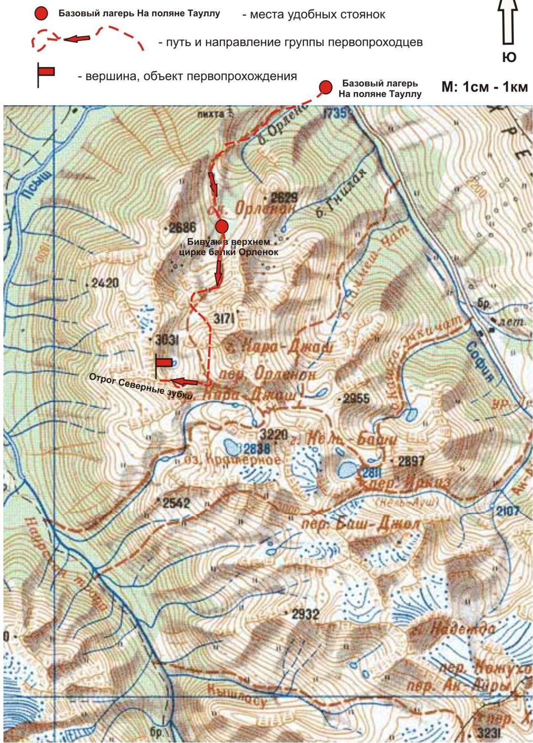
Approach
The ascent is made from a bivouac in the upper cirque of Orlenok ravine. The approach to the bivouac in the upper cirque is not complicated in terms of orientation: from Taullu glade, the location of the base camp, cross the Sofia river by a bridge and ascend along Orlenok ravine — first along a logging road, then along a trail.
The upper cirque is formed by:
- eastern slopes of the northern spur (ridge with a series of unexpressed peaks up to Orlenok Pass);
- western slopes of the Kara-Jash ridge (from Orlenok rock to Orlenok Pass).
The cirque is clearly expressed, snowy in winter and spring off-season, and has two beautiful lakes among small birch and pine groves in summer. The height of the upper cirque of Orlenok ravine is 2200 m above sea level. The ascent from Taullu glade to the upper cirque takes 1.5–2 hours. The cirque has convenient places for tents, with water (streams) and dry areas, freed from snow at the end of April — beginning of May.
Technical part
The route begins with an ascent to Orlenok Pass along snow slopes. On Orlenok Pass, it is necessary to organize teams. Then along the southeast ridge — first along a snowy, then along a not very steep rocky slope — approach the base of the first rocky tower.
The ascent to the first rocky tower ("Eastern Zubok" — 2900) is carried out along a simple inclined slab. Then — descend along a simple rocky ridge, bypass the gendarme on the right and approach the base of the second rocky tower ("Central Zubok" — 3000).
The key to the route — the ascent to the second rocky tower ("Central Zubok" — 3000):
- First, traverse along an oblique rocky shelf;
- then ascend along an inclined smoothed rocky wall.
The summit of the second rocky tower is clearly expressed, and a control cairn was erected on the summit by the participants of the first ascent.
Further:
- rappel to the saddle;
- bypass the gendarme on the right along the way;
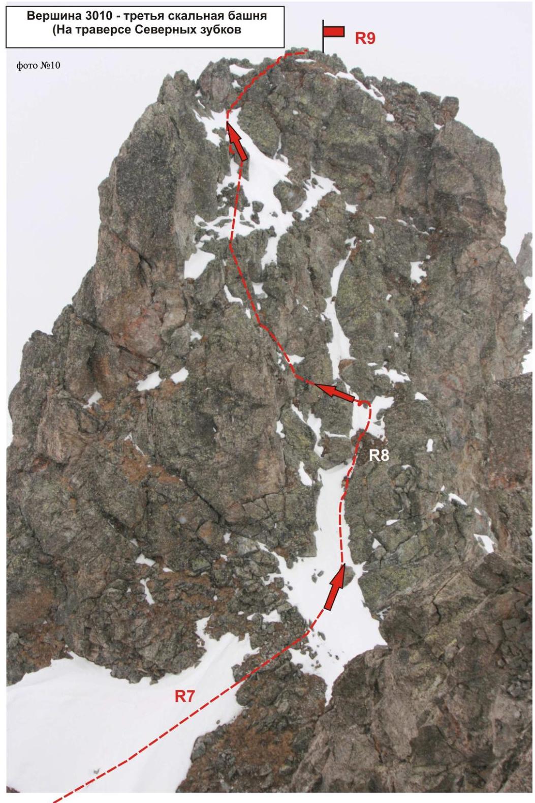
- ascent to the third tower ("Main Zubok" — 3010), marked by a nodal peak of the northwest spur of the mountain massif (on old maps — ridge) Kara-Jash on the map of the Department of Geodesy and Cartography of the Russian Federation.
Ascent to the third tower ("Main Zubok" — 3010):
- Along the wall;
- along the inner corner.
The route is visible from the second rocky tower and after descending from the 2nd rocky tower (from the saddle) — unambiguously, and does not cause problems in orientation. Overcome "head-on". The summit of the tower is peak-shaped, with a small area. Rockfall danger — subjective. In the off-season, there may be formed ice on the rocks. There was no cairn or note on the summits. It can be assumed that this ascent was not only the first ascent of the route but also the first ascent of these peaks. Cairns were erected by the participants of the first ascent.
Descent from the summit
Descent from the summit along the northern rocky slope of the tower (two rappels of 40 m), then along the northeastern slope (sports descents along a steep snowy slope) to the upper cirque of Orlenok ravine until joining the beginning of the ascent. Then along a familiar path — return to the bivouac.
Recommendations for the instructor
In order to reduce the time spent on the ascent, it is advisable to conduct additional rock training with participants before the ascent to work out:
- movement on rocks in crampons;
- organization of rappel descent with rope retrieval.
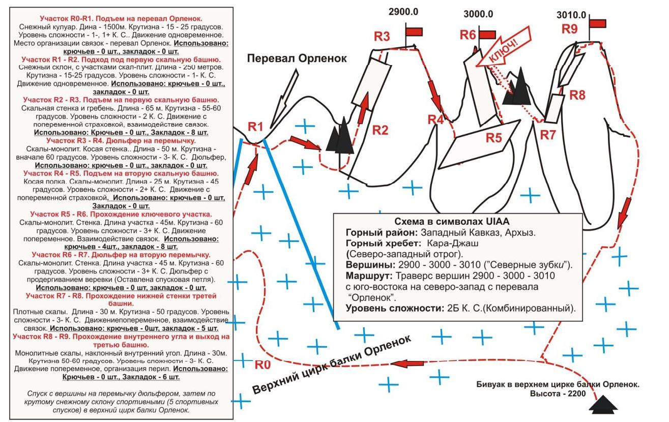
Scheme in UIAA symbols
Mountain region: Western Caucasus, Arkhyz.
Mountain ridge: Kara-Jash (northwest spur).
Peaks:
- 2900
- 3000
- 3010 ("Severnye Zuby").
Route: Traverse of peaks 2900–3000–3010 from southeast to northwest from "Orlenok" Pass.
Level of difficulty: 2B cat. difficulty (combined).
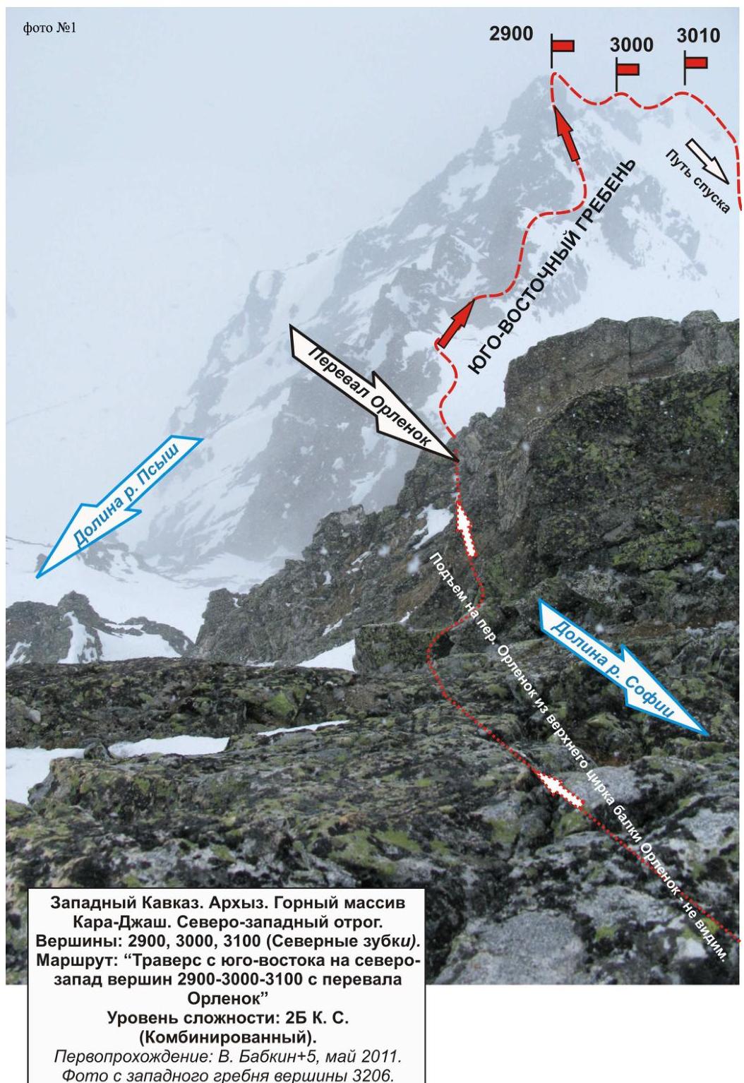
Level of difficulty: 2B cat. difficulty (combined). First ascent: V. Babkin+5, May 2011. Photo from the western ridge of peak 3206.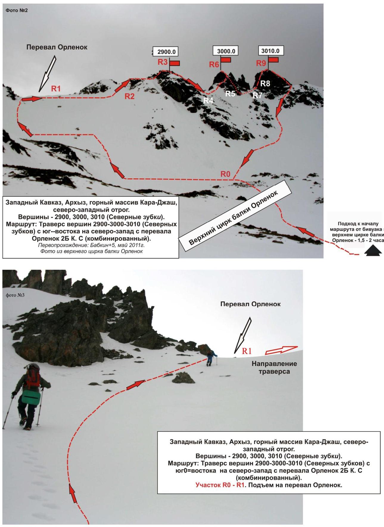
Western Caucasus, Arkhyz, Kara-Jash mountain massif, northwest spur. Peaks:
- 2900
- 3000
- 3010 ("Severnye Zubki")
Route: Traverse of peaks 2900–3000–3010 ("Severnye Zubki") from southeast to northwest from Orlenok Pass 2B cat. difficulty (combined).
Period of passage: Babkin+5, May 2011. Photo from the upper cirque of Orlenok ravine
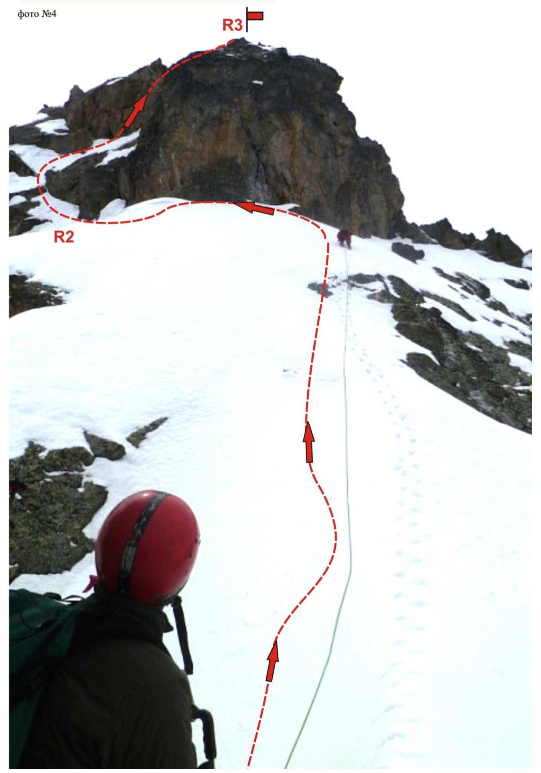
Western Caucasus, Arkhyz, Kara-Jash mountain massif, northwest spur. Peaks:
- 2900
- 3000
- 3010 ("Severnye Zubki")
Route: Traverse of peaks 2900–3000–3010 ("Severnye Zubki") from southeast to northwest from Orlenok Pass 2B cat. difficulty (combined).
Section R0–R1. Ascent to Orlenok Pass.
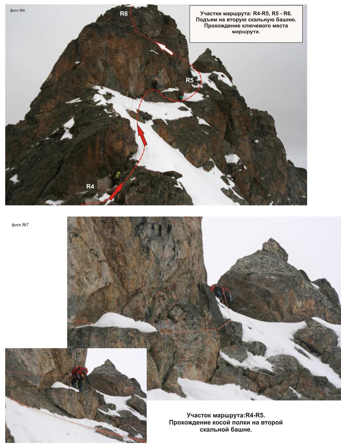
Section R2–R3. Ascent to peak 2900 ("Eastern Zubok")

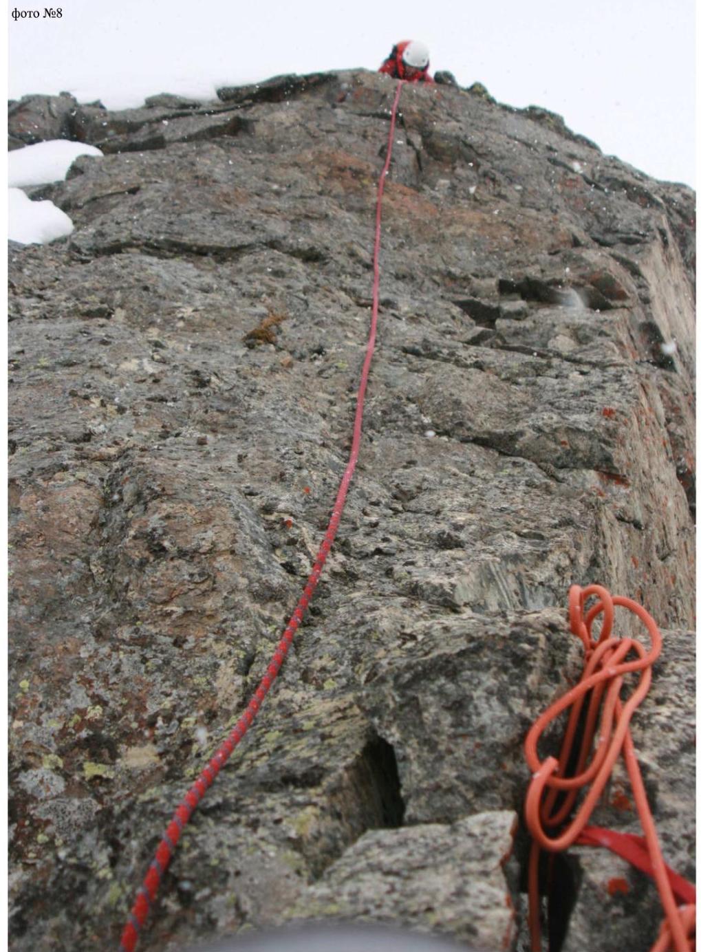
Route sections: R3–R4, R4–R5. Key section of the route.
Route section: R4–R5. Passage of the oblique shelf on the second rocky tower.
Section R5–R6. Ascent to the second rocky tower. Upper part of the key section of the route: rocky wall. Monolith.
- Length — 45 m
- Steepness — 60°
- Level of difficulty — 3+ cat. difficulty.
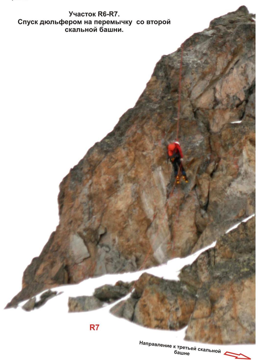
Direction to the third rocky tower
R9. Northwest spur of the Kara-Jash mountain massif. Traverse route from southeast to northwest of peaks:
- 2900
- 3000
- 3010 ("Severnye Zubki")
Peak 3010 ("Main Zubok"). Section R8–R9 (ascent to the rocky tower of the peak).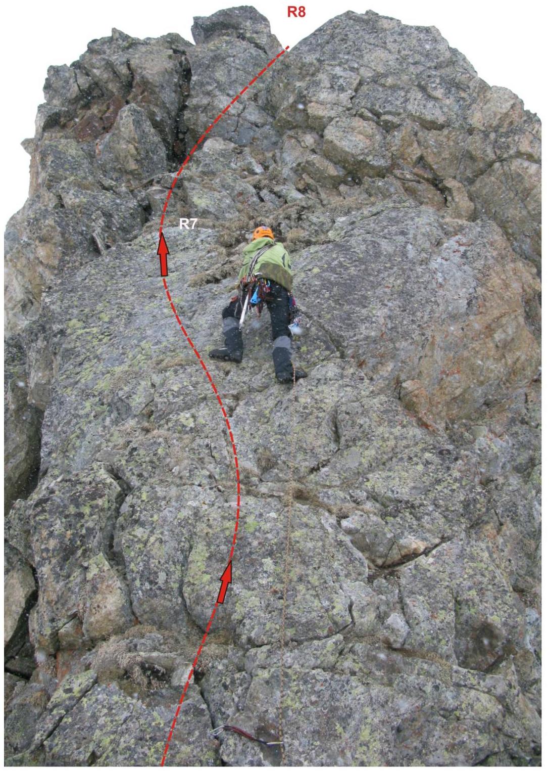
Fragment of the map (Arkhyz) of the climbing area
Additional conventional signs