Passport
- CLIMBING CLASS – rock climbing
- CLIMBING REGION – Western Caucasus, Arkhyz, Sofiyskiy Ridge between the upper reaches of the Sofiya and Psysh rivers
- SUMMIT – peak "Panagyurishte" (proposed by the first ascenders) 3073 m via the 3rd buttress
- ROUTE CHARACTERISTICS – rock climbing on the buttress, height difference – 240 m, average steepness – 45°
- PROPOSED DIFFICULTY GRADE – 2B
- PITS DRIVEN – 10 rock anchors for belaying and self-belaying
- TOTAL CLIMBING TIME – from the start of the route to the summit 3.5 hours
- NUMBER OF OVERNIGHTS – not required on the route
- CLIMB LEADER: Oleinikov N.P. – Candidate Master of Sports
PARTICIPANTS:
- Samorezov V.P. – 1st sports category
- Karpinskiy O.D. – Candidate Master of Sports
- Tretyakov V.Ya. – 1st sports category
TEAM COACH – Lamiandi I.G. – Master of Sports
DATE OF DEPARTURE AND RETURN – July 24, 1980

The ascent to the unnamed peak 3073 m was made on July 24, 1980. No traces of earlier ascents were found. The peak is located in the Northern spur of Mt. Sofiya and is situated between the 3150 m peak and the "175 years of Kislovodsk" peak.
To the west of the summit, a series of buttresses extends, interspersed with steep scree-filled couloirs. To the east, it drops with steep (up to 80°) walls, about 100 m high, onto the NW Sofiyskiy glacier. The steep Southern ridge has a blocky structure and does not present technical difficulties. The unnamed 3150 m peak, located in the same spur, may be of certain sporting interest. From the NW Sofiyskiy glacier, a route up to the second difficulty grade is possible. To the west of it, a short ridge extends, terminating in a sheer wall about 300–400 m high above the Ak-Ayry glacier.
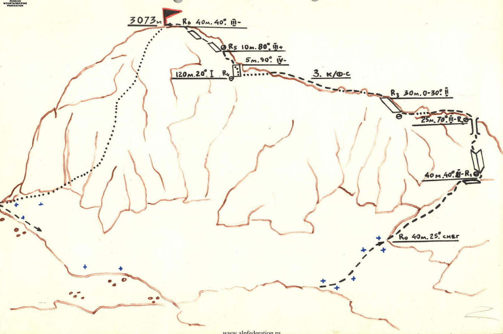
Route Description
From the base camp located at the "Ice Farm" in the upper reaches of the Sofiya River (T 20 m), follow the direction of the Ak-Ayry waterfalls upstream along the eponymous stream, which flows into the Sofiya River from the left near the farm (see diagram). Cross the Sofiya River and the mouth of the Ak-Ayry River via footbridges and follow a well-trodden path on the left (orographically) to approach the amphitheater of steep slopes and rocks from which a series of beautiful waterfalls cascades. Turn left and traverse the grassy slopes with a gradual ascent to reach the "ram's foreheads."
To the right of the waterfall, ascend steeply via the "foreheads" to a flat clearing located to the right (in the direction of travel) of the river – the bivouac site. From the "Ice Farm," it takes 2.5–3 hours on foot. To the left of the bivouac, behind the ridge – the "Fence" – lies the characteristic pointed peak of the Unnamed summit – the object of our ascent.
From the bivouac, follow the left side of the stream upwards via small scree that transitions into large boulder slabs – approach the NW wall of the peak – the start of the route. From the bivouac, it takes 1.5–2 hours.
Section R0–R1
In the right part of the wall, ascend via an oblique ledge that leads upwards to the right onto the buttress (30 m). Continue straight up via smooth rocks with small holds – reach an internal corner (10 m). Piton belay.
Section R1–R2
Ascend the internal corner, which transitions via a wide ledge into a 10-meter chimney with an abundance of good holds – reach the ridge. Piton belay.
Section R2–R3
The ridge is destroyed and gentle. Bypass a small gendarme on the right; further, a rock face with smooth slabs. Piton belay.
Section R3–R4
After the rock face – continue straight along the ridge, on its right side (simultaneous movement, belaying via outcrops) – to the summit tower – 100–120 m.
Section R4–R5
Key section. Ascend to the right up a sheer wall – 5 m. Piton belay. Continue via sheer blocks with a transition to the left side of the ridge – 10 m. Piton belay!
Section R5–R6
40 m along steep, smooth slabs to the left and upwards to the summit. Piton belay! The total ascent time from the start of the route is 3–3.5 hours.
Descent:
- Via the Southern ridge onto the NW Sofiyskiy glacier and further around via the saddle between the "175 years of Kislovodsk" peak and the Unnamed peak ("Panagyurishte") – to the bivouac – 1.5 hours.
The total time for the ascent is 10–11.5 hours.
Transitions:
- Base camp "Ice Farm" – "Bivouac" – 2.5–3 hours
- "Bivouac" – start of the route – 1.5–2 hours
- Start of the route – summit – 3–3.5 hours
- Descent to "Bivouac" – 1.5 hours
- "Bivouac" – base camp – 1.5 hours
The ascent was made in ideal conditions; under less favorable conditions, the route may prove significantly more challenging. The group did not find any traces of climbers on peak "Panagyurishte," nor along the entire route – the summit cairn was built for the first time.
The first ascent of the Unnamed peak (3073 m) was made on July 24, 1980, by members of the Pyatigorsk Alpine Section with the aim of naming it after Pyatigorsk's twin city – the Bulgarian city of Panagyurishte:
- Oleinikov N.P. – Candidate Master of Sports
- Samorezov V.P. – 1st sports category
- Karpinskiy O.D. – Candidate Master of Sports
- Tretyakov V.Ya. – 1st sports category
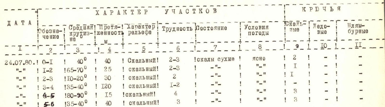
Table of main characteristics of the first ascent route to peak "Panagyurishte" via the Western buttress, approximately 2B difficulty grade
| DATE | Designation | Average steepness | Length | Terrain character | Difficulty | Condition | Weather conditions | Rock anchors | Ice anchors | Bolt anchors |
|---|---|---|---|---|---|---|---|---|---|---|
| 24.07.1980 | R0–R1 | 40° | 40 m | rock climbing | 2–3 | dry rocks | clear | 2 | – | – |
| " | R1–R2 | 65–70° | 25 m | rock climbing | 2–3 | " | " | 1 | – | – |
| " | R2–R3 | 10–20° | 30 m | rock climbing | 2 | " | " | 1 | – | – |
| " | R3–R4 | 35–40° | 120 m | rock climbing | 1–2 | " | " | – | – | – |
| " | R4–R5 | 80–90° | 15 m | rock climbing | 4 | " | " | 3 | – | – |
| " | R5–R6 | 35–40° | 40 m | rock climbing | 3 | " | " | 3 | – | – |
Note: On the descent from the summit, the SW ridge is destroyed. There are loose rocks. The difficulty grade of the descent ridge is 1B.

Orographic diagram of the upper reaches of the Ak-Ayry River (Arkhyz)
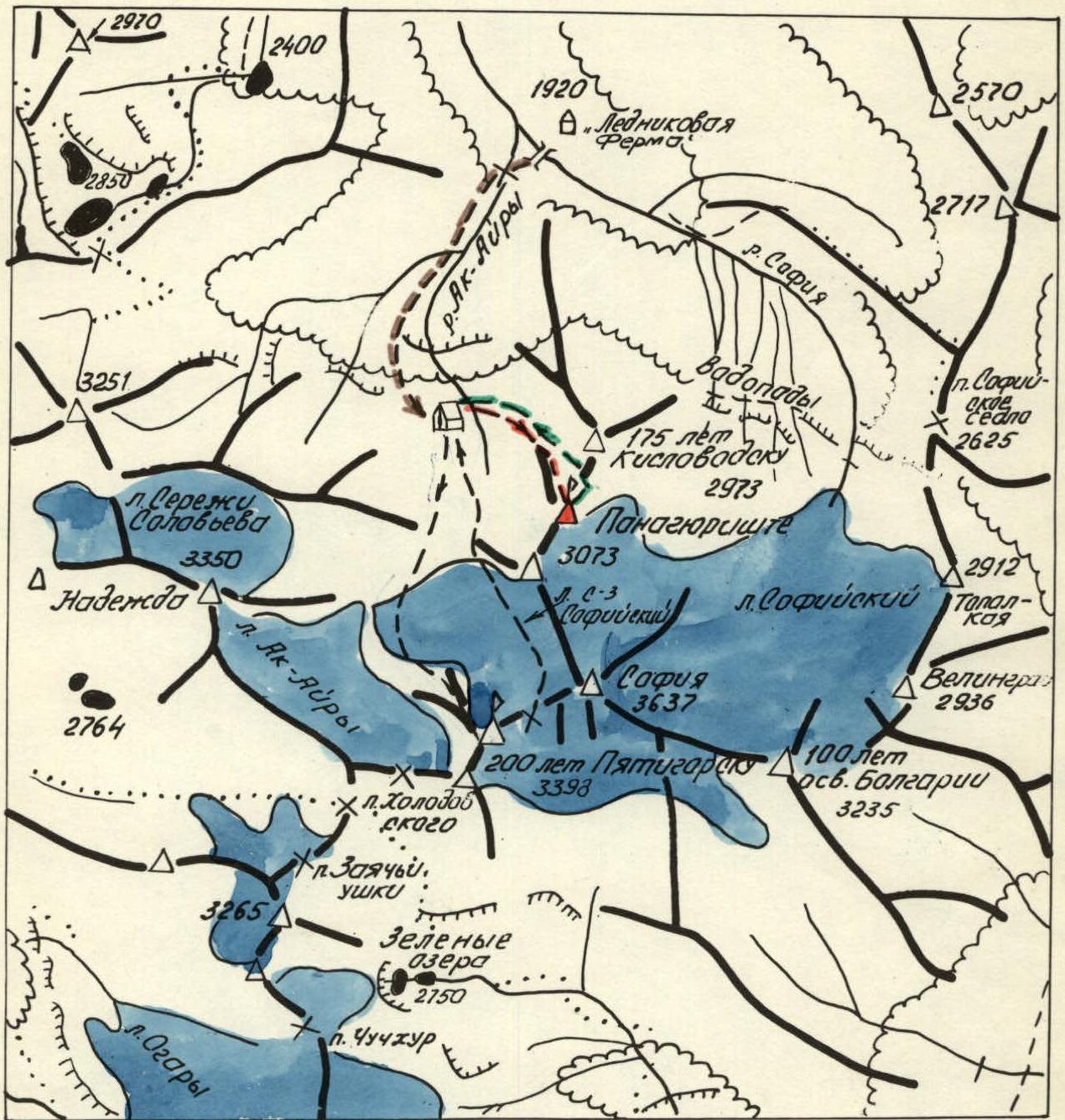
Legend:
- Path to the base camp
- Ascent route to peak "200 years of Pyatigorsk" (2A difficulty grade)
- Descent route from peak "200 years of Pyatigorsk"
- Ascent route to peak "Panagyurishte" (~2B difficulty grade)
- Descent route from peak "Panagyurishte"
- Base camp location