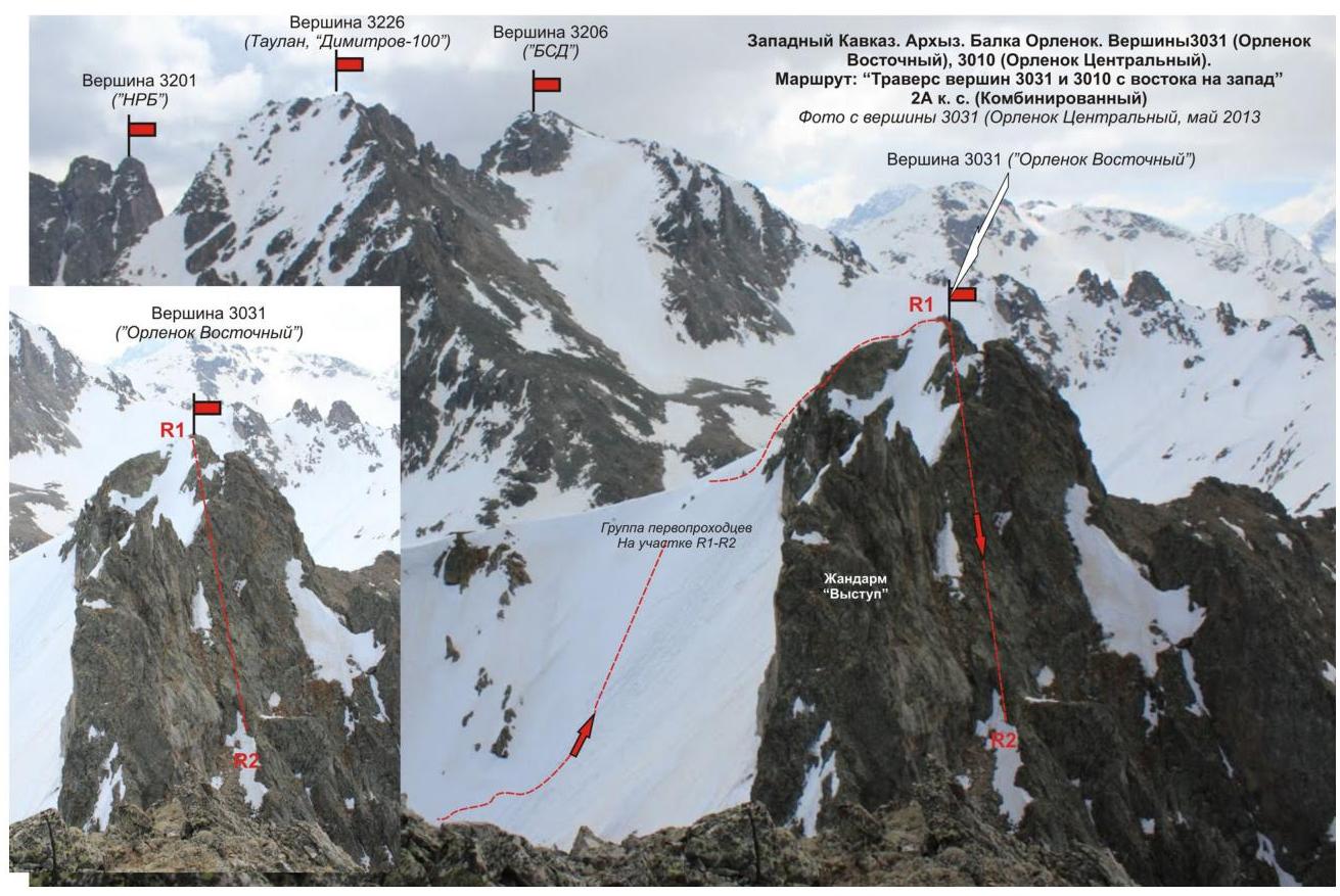
Peaks 3031–3007 (Orlenok Vostochny — Orlenok Tsentralny) Route: traverse of peaks 3031 and 3010 from east to west Cat. diff. — 2A (combined) Leader: S. Bernatsky Western Caucasus, Arkhyz, Orlenok balk, Orlenok mountain spur Section in KMGV — 2.1.
E-mail — ZHUR58@RAMBLER.RU
Report
On the first ascent of the mountaineering route to peaks 3031–3007 (Orlenok Vostochny — Orlenok Tsentralny) "Traverse of peaks 3031 and 3010 from east to west"
2A cat. diff. (combined). At the competitions in mountaineering "Pobeda Cup" NP "Club of Northern Travels "Sauk-Pai"" (class "First Ascents") in May 2013.
Region: Karachay-Cherkess Republic Mountain country: Western Caucasus Gorge: Orlenok balk Ridge: Orlenok mountain spur Peaks:
- Peak 3031 (Orlenok Vostochny)
- Peak 3010 (Orlenok Tsentralny) Route: traverse of peaks 3031 — 3010 from east to west 2A cat. diff. Difficulty level: 2A cat. diff. (combined) (approximately)
Prepared by:
- S. Bernatsky
- S. Zhuravlev May, 2013
Description of the peak
Peaks 3031 (Orlenok Vostochny) and 3010 (Orlenok Tsentralny) — the main peaks of the Orlenok mountain spur, the extreme western spur of the Sofiysky ridge. The Orlenok mountain spur is a watershed of the Psyish river valley (to the west) and the Orlenok river valley (to the north-east). Located on the territory of the North Caucasus Federal District of the Russian Federation, in the Karachay-Cherkess Republic, Arkhyz mountain region.
Peaks 3031 (Orlenok Vostochny) and 3010 (Orlenok Tsentralny) — ярко expressed peaks of the Orlenok mountain spur, located in the south-western part of the Orlenok balk, opposite the nodal peak Kara-Djash (3171.0). The peaks are easily identifiable from the upper cirque of the Orlenok balk as the highest peaks in the right part (along the path).
The peaks do not have official names, so they have conditional tourist and mountaineering names:
- Orlenok Vostochny
- Orlenok Tsentralny
The names are given according to the name of the balk in which they are located.
Description of the route
The route "Traverse of peaks 3031 and 3010 from east to west" — a typical training and sports combined route of 2A cat. diff., with a full set of natural obstacles corresponding to routes of this level.
Equipment
To complete the ascent as part of a sports team of 4 people on the route, the following special equipment is required:
Personal:
- Standard
- Crampons
- Ice axe
Group:
- Main rope 10 mm — 2 × 50 m
- Rock hammer — 2 pcs.
- Rock pitons — 16 pcs.
- Ice axe — 1 pc.
- Chocks — 12 pcs.
- Friends — 6 pcs.
- Ice screws — 0 pcs.
- Quickdraws — 16 pcs.
- Loops — 10 pcs.
Approach
The ascent is made from a bivouac in the lower cirque of the Orlenok balk.
Approach to the lower cirque: from the Taulu glade, cross the Sofiya river by bridge and ascend along the Orlenok balk — first along a forest road, then along a well-defined trail.
The cirque is ярко expressed:
- in winter and spring off-season — snowy,
- in summer — overgrown with high-altitude vegetation.
The height of the cirque above sea level is 1600 m. The ascent from the Taulu glade to the cirque takes 1.5–2 hours.
In the lower cirque of the Orlenok balk, there are convenient places for tents, with:
- water (streams),
- firewood for a campfire,
- dry areas, freed from snow in late April — early May.
Approach to the start of the route: from the base camp in the lower cirque of the Orlenok balk, ascend along the trail to the upper cirque of the Orlenok balk. In the panorama of the cirque, peaks 3031 (Orlenok Vostochny) and 3010 (Orlenok Tsentralny) are not immediately visible; it is necessary to ascend to the upper cirque of the Orlenok balk and pass under the slopes of peak 3226. To the right along the path, there will be a long snowy slope — this is the start of the route — the north-eastern slope of peak 3031 (Orlenok Vostochny).
The approach from the campsite in the lower cirque of the Orlenok balk to the start of the route — the snowy north-eastern slope of peak 3010 (Orlenok Vostochny) — takes about one and a half hours.
Technical part
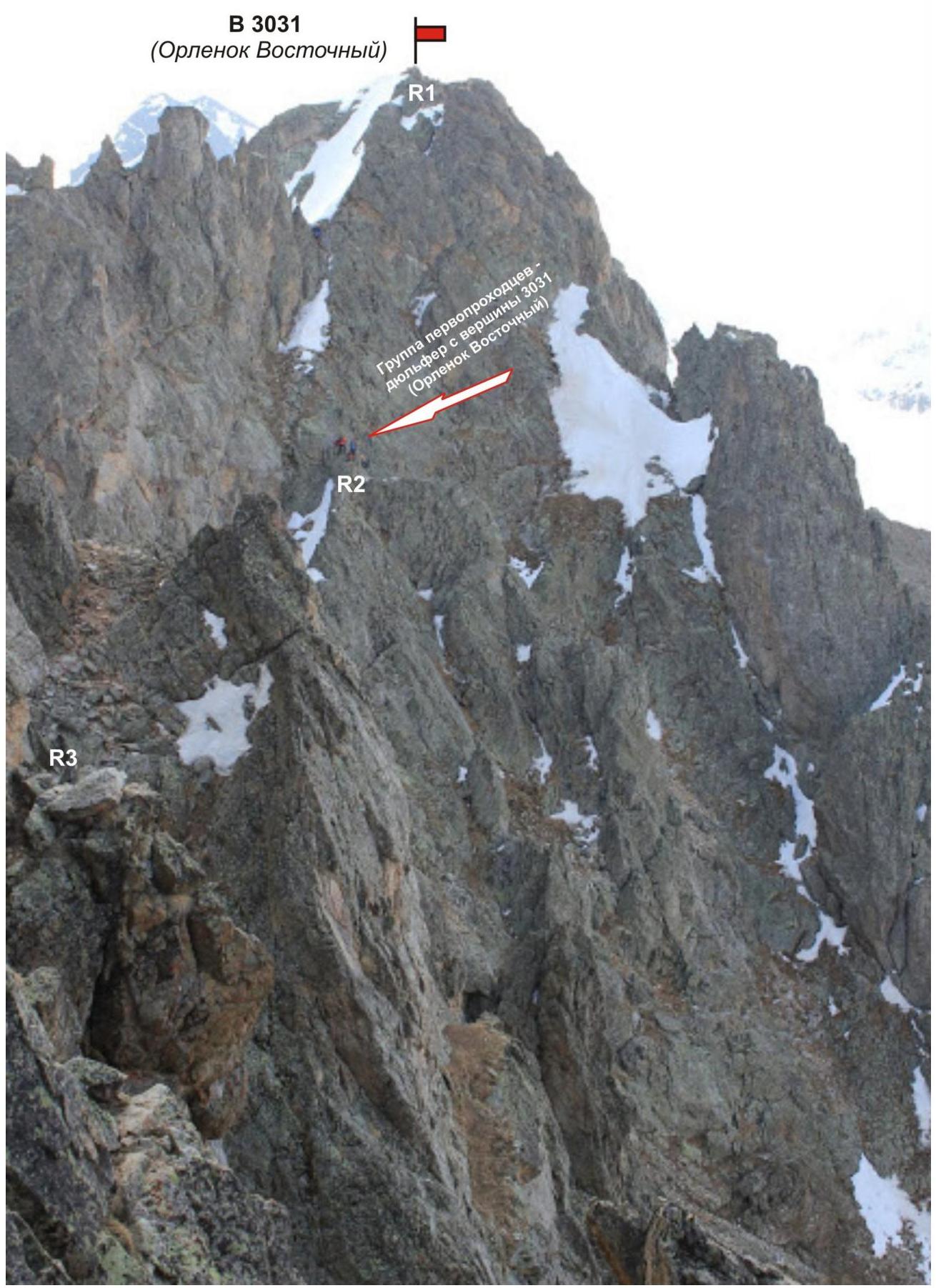
The place for organizing rope teams is at the foot of the north-eastern slope. Then, ascend along the north-eastern slope (route 1B cat. diff.) to peak 3031 (Orlenok Vostochny).
From the peak:
- a косой дюльфер (diagonal rappel) for the entire length of the rope to the left along the path to the talus shelves;
- traverse along a series of shelves along a series of ridge жандармов (gendarmes);
- approach the base of a pronounced internal angle.
The internal angle is the key to the route.
The key to the route — a pronounced internal angle of 15 m with complicated climbing on dense rocks.
After passing the key, along a series of shelves and a rocky ridge, exit to peak 3010 (Orlenok Tsentralny).
The peaks are ярко expressed. The summit cairns are easily found. Descent: after completing the traverse, descend along the western ridge to the western rocky shoulder, then along a talus narrow couloir under the base of the eastern bastion of peak 3010 (Orlenok Tsentralny).
To return to the base camp in the Orlenok balk, it is necessary to cross the watershed ridge.
Recommendations for the instructor
Due to the accessibility of the original route, it can be recommended for both training and sports teams (NP-2) and for independent sports groups of разрядников (discharge holders) making руководства (guided climbs) or тренировочные восхождения (training ascents).
Time costs for completing the route for a training and sports team of разрядников of average level of preparation (NP-2):
- 8–10 hours
Passport
- Number of the section according to KMGV — 2010 — 2.1.
Western Caucasus, mountain region — Arkhyz, mountain spur — Orlenok
- Name of the peak: 3031–3010 (Orlenok Vostochny — Orlenok Tsentralny) 3. Height: 3031–3010
- Route: traverse of peaks 3031 and 3010 from east to west
- Category of difficulty: 2A cat. diff.
- Character of the route — combined.
- Height difference of the route: 831 m
- Length of the route: 740 m
- Length of sections of the highest cat. diff.:
1 cat. diff. — 2 sections — 650 m 2 cat. diff. — 1 section — 25 m 3 cat. diff. — 2 sections — 65 m
4 cat. diff. — 0 sections — 0 m 5 cat. diff. — 0 sections — 0 m 6 cat. diff. — 0 sections — 0 m
- Average steepness: — 50 degrees.
- Number of pitons used:
Total number used on the route:
- rock pitons — 1
- chocks — 6
- stationary pitons — 0
- ITO — 0
- removable pitons — 0. Number of pitons left on the route: total — 0; including stationary — 0.
- Departure on the route — 4:30, May 8, 2013
Ascent to the peak — 12:00, May 8, 2013 Return to the base camp — 15:00, May 8, 2013
- Time spent by the team: — 11 hours.
- Leader: S. Bernatsky (MS, инструктор-методист 2 cat. diff., Yekaterinburg).
Participants:
- Z. Khasanov (Kazan, 3rd sports разряд)
- V. Plotnikov (Voronezh, 3rd sports разряд)
- M. Bykova (Kazan, 3rd sports разряд)
- K. Tatrik (Voronezh, 3rd sports разряд).
- Trainer: Zhuravlev Sergey Vasilyevich, title — KMS, инструктор-методист 1 cat. diff.
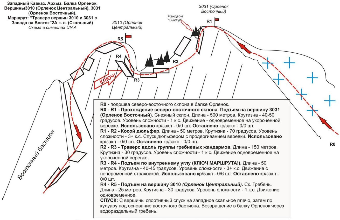
Western Caucasus, Arkhyz, Orlenok balk, Peaks 3031 (Orlenok Vostochny) — 3010 (Orlenok Tsentralny). Route: "traverse from 3031 to 3010 from east to west" 2A (combined) (approximately) (table of natural obstacles on the route)
| Section № | Length | Steepness | Character of relief | cat. diff. | Number of pitons/chocks |
|---|
R0 — line of the foot of the North-Eastern slope. R0–R1 Ascent along the NE slope to peak 3031 Orlenok (V) along route 1B cat. diff. R1–R2 Descent to a series of shelves R2–R3 Traversing a series of ridge жандармов (gendarmes) R3–R4 KEY! Convenient place for organizing rope teams
| 500 | 40 | Snow. | 1 | 0 / 0 |
|---|
150 m 30° Rocky shelves. 1 0/0
| 1 | 0 / 0 | | :-- | :-- | :-- |
15 m 65° Rock wall, internal angle 3+
| Passing the internal angle | |||||
|---|---|---|---|---|---|
| R4–R5 Exit to peak 3010 (Orlenok Tsentralny) | 25 | 30 | Series of inclined shelves. | 1,2- | 0 / 0 |
| R5–peak 3010 (Orlenok Tsentralny) | ярко expressed. Summit cairn in the center. | ||||
| Descent | Along the western ridge to the rocky shoulder, then descent along the couloir under the base of the eastern bastion. |
Summary
Length of the route — 740 m. Average steepness — 50°. Character of relief — combined. Sections:
- 1 cat. diff. — 2 sections — 650 m
- 2 cat. diff. — 1 section — 25 m
- 3 cat. diff. — 2 sections — 65 m.
Number of pitons and chocks used: 1/6. Number of pitons and chocks left: 0/0.
Western Caucasus. Arkhyz. Orlenok balk. Peaks:
- 3031 (Orlenok Vostochny)
- 3010 (Orlenok Tsentralny)
Route: "Traverse of peaks Orlenok (V) — Orlenok (T) from east to west" 2A cat. diff. (Combined).