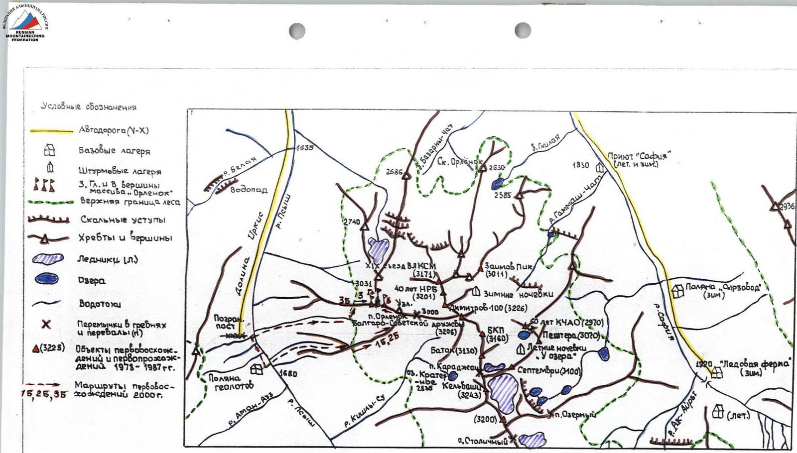
Fig. 1. Map of the Orlenok massif area. Peaks: Western (3180 m), Main (3190 m), Eastern (3140 m). On the map - З, Гл, В.
Ascent Passport
- Ascent class: rock climbing
- Ascent area: Karachay-Cherkess Republic, Arkhyz, Psyish River valley
- Peak, route: Orlenok Eastern, 3140 m via Western spur and South-Eastern ridge
- Expected complexity category: 1B, first ascent
- Height difference:
- 600 m;
- total route length - 1500 m;
- average steepness of the route - 40°
- Number of pitons hammered and/or placements made: 2 placements
- Number of travel hours: 12 hours (from base camp to the summit and back)
- Overnight stays: not required on the route
- Leader: Zaporozhchenko E. V., Candidate for Master of Sports, instructor.
Team members:
- Roshchin Yu. I., 1st sports category, instructor
- Tulisova N. III category
- Meshcheryakov D. III category
- Sadovoi M. A. III category
- Shamrin A. V. III category
- Coach: Abduramanov R. U., Master of Sports
- Route entry and exit date: May 4, 2000
The Orlenok massif is located at the node of the diverging extreme western and northern branches of the Sofiyskiy ridge (see Map). It does not have a proper name. The well-known "Orlenok rock" among tourists is located much further north and 500 m lower (2629 m) than this massif. Apparently, due to its seeming inaccessibility, surveyors did not visit the summit part of the massif, and as a result, its exact absolute positioning is missing on topographic maps with a scale of 1:25,000 (T-38-22-A-b; A-50-17-V-b). The nearest summit reference point is located 1 km north (on the ridge lowering) and has a mark of 3031 m. The massif, being the object of first ascents, is 150-200 m higher than this point. Considering that the nearest Orlenok pass (~ 1 km along the ridge to the southeast) - according to the 1:100,000 map "Arkhyz" published in 1999, has been assigned a mark of 3000 m, the Main peak of the described massif should have a mark of ~ 3190 m.
There are three peaks in the massif: Western, Main, and Eastern (3160, 3190, and 3140 m, respectively). They are clearly visible from the "Psysh River pinching" spot to the left bank of the valley (near the border post), the first Psyshnaia glade ("Geologists' Glade", Photo 1), and further along the Psyish River valley. Above the Irkis valley (mouth of the Belaya River and other rivers flowing from the Gobuлу ridge), only the rock tower ending of the Sofiyskiy ridge with an absolute mark of 2740 m is visible.
The approach to the start of the route can be made either from the "Geologists' Glade" base camp (see Fig. 1, 1680 m) or from the border post at the "pinching", where the dirt road along the Psyish River valley (Irkis valley) ends.
There is a crossing over the Psyish River opposite the "Geologists' Glade", and in the spring, until mid-May, when a snow bridge from avalanche snow remains - and at the border post (for example, in May 2000), this allowed unhindered crossing from the left bank of the Psyish River to the right.
From the "pinching", where the dirt road ends, to the "Geologists' Glade" is 20-30 minutes of walking along the left (orographic) bank with crossing the cones of annually descending winter avalanches.
The approach to the start of the route begins from the crossing over the Psyish River and goes up along the stream (avalanche chute) flowing from under the Uzlovaya peak (see Photo 2). Between the first and second waterfalls, it is necessary to turn left and exit to the Western spur, going from the Uzlovaya peak of the Sofiyskiy ridge to the southwest from the Orlenok pass. The exit to the rock base of the spur is immediately behind the upper forest boundary (~ 2540 m). Start of the route. 4-5 hours from the "Geologists' Glade" base camp.
Route Description
Section R0-R1 (see UIAA Sketch and Diagram Fig. 2). Along the watershed line of the spur, most often slightly to the right (in the direction of travel) - simultaneous movement towards Uzlovaya. To the left and right (especially to the left) - avalanche-saturated slopes (Photo 3). About 0.8-1 km of ascent with an average slope of 30°. The Uzlovaya massif will be visible only at the end of the section (it is not visible from the "Geologists' Glade" base camp). Complexity category: 1.
Section R1-R2. Under the Uzlovaya massif, crossing a steep (up to 60°) snow slope, with an inclined traverse with ascent to the southeast ridge, exit to the ridge. The length of the steep part of this traverse, requiring placement of a rope, is 60-80 m. Total - 100 m. Complexity category: 2.
Section R2-R3. Gently (~25°) rising towards the base of the Eastern peak tower, the ridge is composed of granite-gneisses with small gendarmes, bypassed on the left. 400 m. Complexity category: 2. 1 hour of walking.
Section R3-R4. The key point of the route. The tower of the Eastern peak (Photo 5). At the base - a wide viewpoint. A good spot for a bivouac (water from snow). The route goes along the right part of the southeast wall. The first 60 m - up to 80°, complexity 3, the second ~ 45°, complexity 3. 2 placements. Ropes for novices are mandatory!
The cairn on the summit was built for the first time. Descent is via the ascent route. With favorable snow conditions, it is possible to descend relatively quickly to the "pinching" along previously descended avalanches. However, this path is not suitable for a team of novices (at least in the spring).
The group took 12 hours to move from the base camp at "Geologists' Glade" to the summit and back.
For novices, the route, requiring good physical fitness, may take up to 16 hours ("from camp to camp"). We emphasize the need for care when descending along steep snow fields. Continuing the route with a traverse and descent to the saddle and ascent to the Main peak is estimated at ~ 2B complexity category and includes:
- traverse,
- descent to the saddle,
- ascent to the Main peak.
Compiled by: E. V. Zaporozhchenko, Pyatigorsk
May 15, 2000
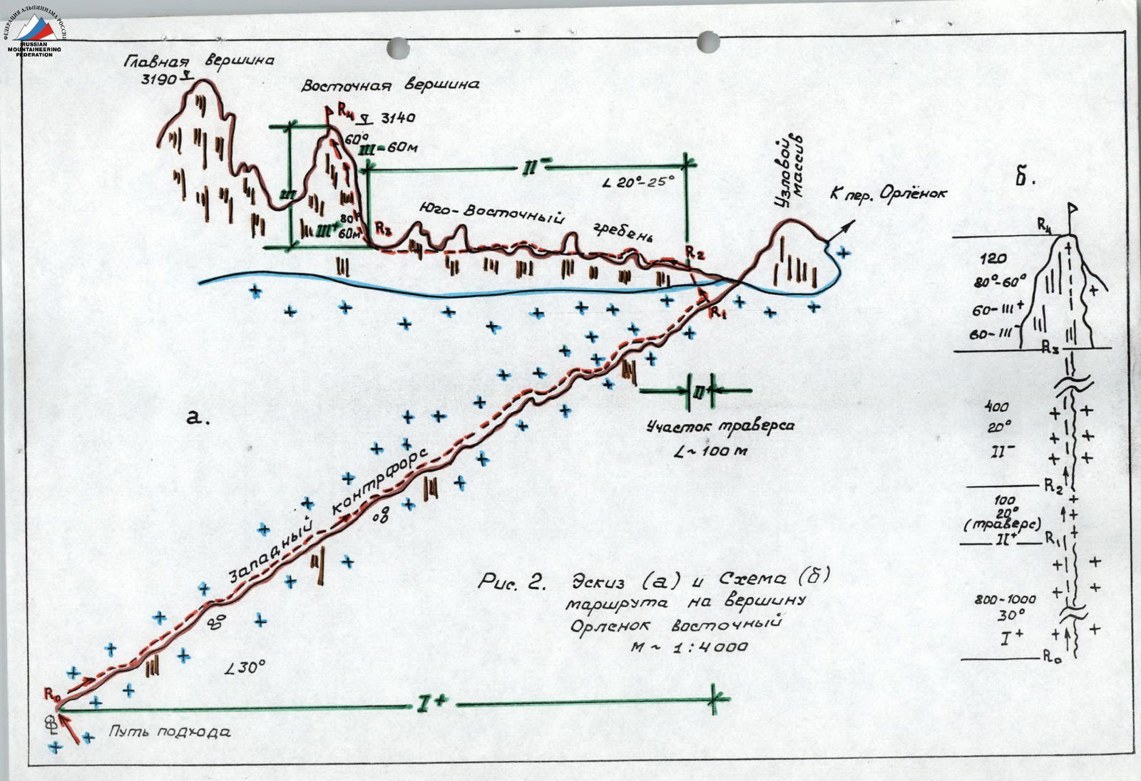
Fig. 2. Sketch (a) and Diagram (b) of the route to Orlenok Eastern peak. M ~ 1:4000.

Photo 1-2000. View of the Orlenok massif (P) from "Geologists' Glade". Path of approach and exit to the Western spur.
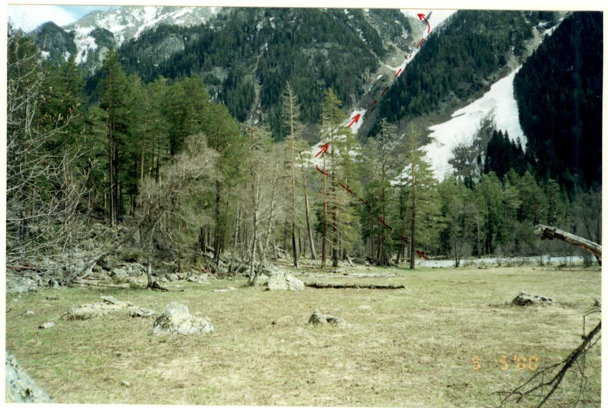
Photo 2-2000. Path of approach from the crossing near "Geologists' Glade".
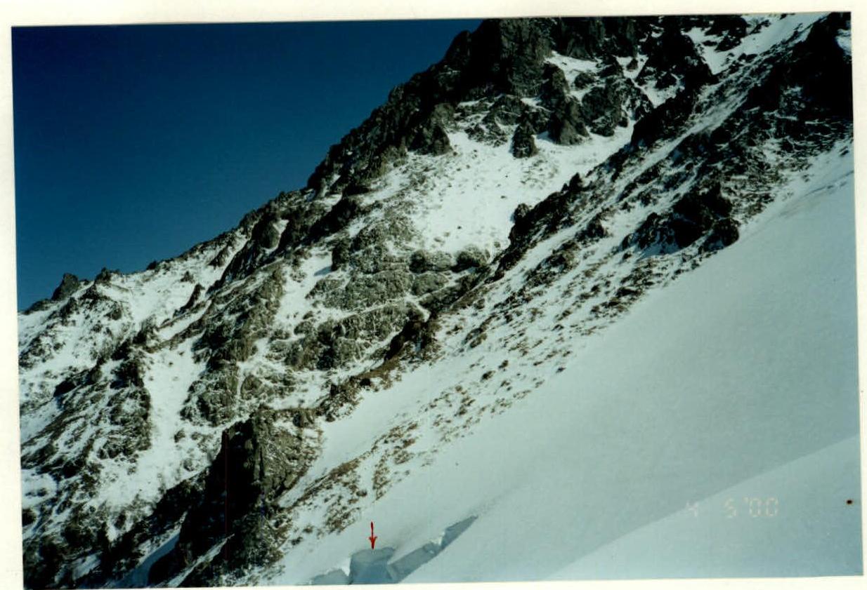
Photo 3-2000. Avalanche release line (↓). View to the North from R0.
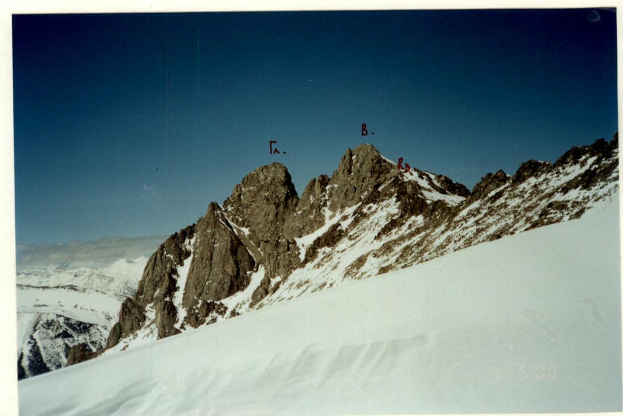
Photo 4-2000. Main (Gл.) and Eastern (В.) peaks of the Orlenok massif. View from the Western spur.
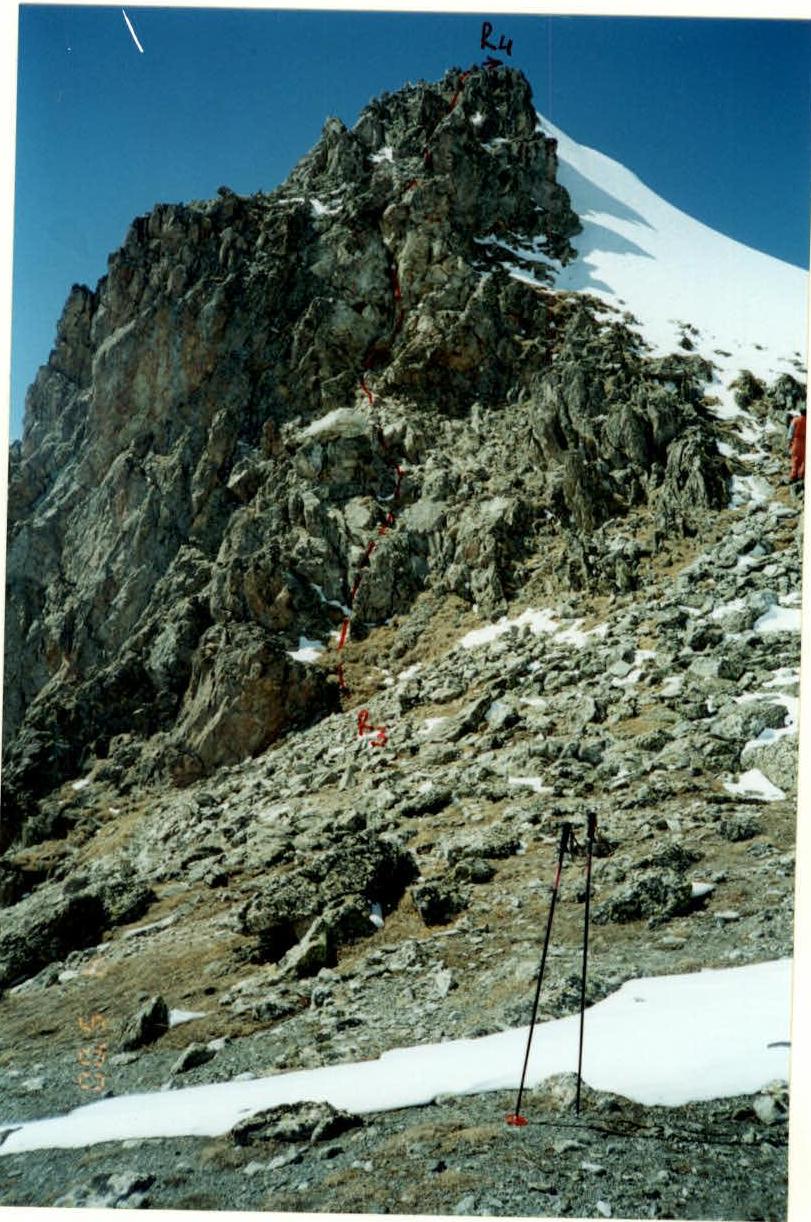
Photo 5-2000. Tower of the Eastern peak. Section R3-R4.