Ascent Route
Climbing type — rock. Climbing area — Caucasus, Krasnodar Krai. Peak, its height, ascent route — Lajub via N-E wall, 2998 m. Proposed difficulty category — 5B (KTPV, 2.1 clause 6). Route characteristics:
- Elevation gain — 900 m
- Length of sections:
- R4 category: 620 m
- R5 category: 440 m
- R6 category: 110 m
- Average steepness of the route — 50–52°
- Wall section steepness — 72–75°
- Pitons driven:
- For belay: rock — 66, ice (in rock) — 7, bolt — 7.
- For creating ITO: rock — 9, bolt — 2.
Number of climbing hours:
- 18 climbing hours
- 5 hours of preliminary processing
Number of bivouacs and their characteristics: one, sitting, platform on a snow-ice ridge.
Surname, name, and patronymic of the leader, participants, and their qualification:
- Stavnider A.M., CMS, instructor — leader
- Gorbenko M.M., 1st sports category — participant
- Alperin B.M., 1st sports category — participant
- Leontiev V.G., 1st sports category — participant
- Nedyupov B.A., CMS, instructor — participant
Coach: Sviridenko V.S., MS
Date of departure and return: April 30 – May 1, 1977

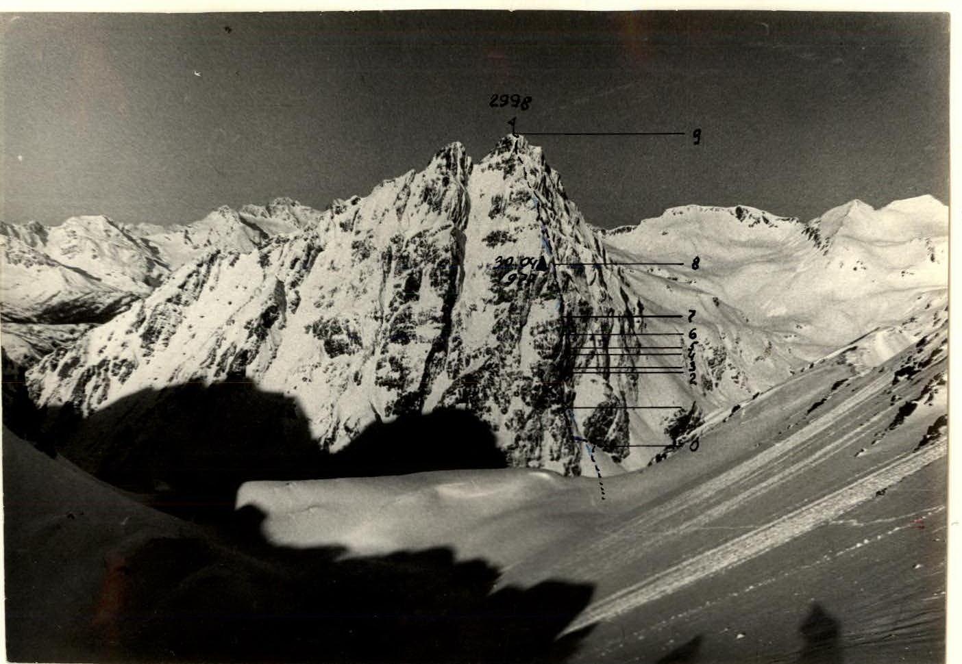
 TABLE OF MAIN ROUTE CHARACTERISTICS
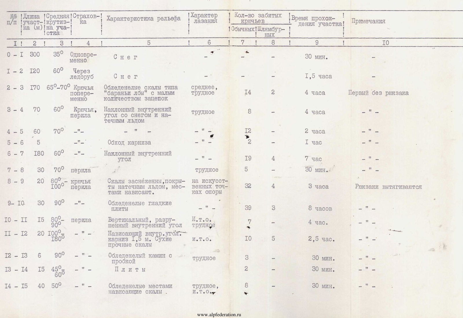
| Section | Length (m) | Steepness | Belay | Terrain characteristics | Climbing character | Regular | Bolt | Time | Notes |
|---|---|---|---|---|---|---|---|---|---|
| R0–R1 | 300 | 35° | Simultaneous | Snow | — | 30 min. | |||
| R1–R2 | 120 | 60° | Through ice axe | Snow | — | 1.5 h | |||
| R2–R3 | 170 | 65–70° | Pitons alternately | Icy rocks like "ram's foreheads" with few holds | medium, hard | 14 | 2 | 4 h | First without a backpack |
| R3–R4 | 70 | 60° | Pitons, railings | Inclined inner corner with snow and ice formed on the rock | hard | 8 | 4 h | — | |
| R4–R5 | 60 | 70° | — | — | — | 12 | 2 | 2 h | — |
| R5–R6 | 5 | Bypassing a cornice | — | — | 1 h | — | |||
| R6–R7 | 180 | 60° | — | Inclined inner corner | — | 19 | 4 | 7 h | — |
| R7–R8 | 30 | 70° | Railings | — | hard | 5 | 30 min. | — | |
| R8–R9 | 20 | 80–100° | Pitons, railings | Rocks are snow-covered, covered with ice formed on the rock, overhanging in places. | on artificial holds | 32 | 4 | 3 h | Backpacks are pulled out |
| R9–R10 | 30 | 90° | — | Icy smooth slabs | — | 39 | 3 | 8 h | — |
| R10–R11 | 15 | 80–90° | Railings | Vertical, destroyed inner corner | I.T.O., hard | 7 | 4 h | — | |
| R11–R12 | 20 | 100–180° | — | Overhanging inner corner., cornice 1.5 m. Dry, strong rocks | I.T.O. | 10 | 5 | 2.5 h | — |
| R12–R13 | 6 | 90° | — | Icy chimney with a plug | hard | 3 | 30 min. | — | |
| R13–R14 | 15 | 45–60° | — | Slabs | — | 2 | 30 min. | — | |
| R14–R15 | 40 | 50° | — | Icy, overhanging rocks in places | hard, I.T.O. | 8 | 30 min. | — | |
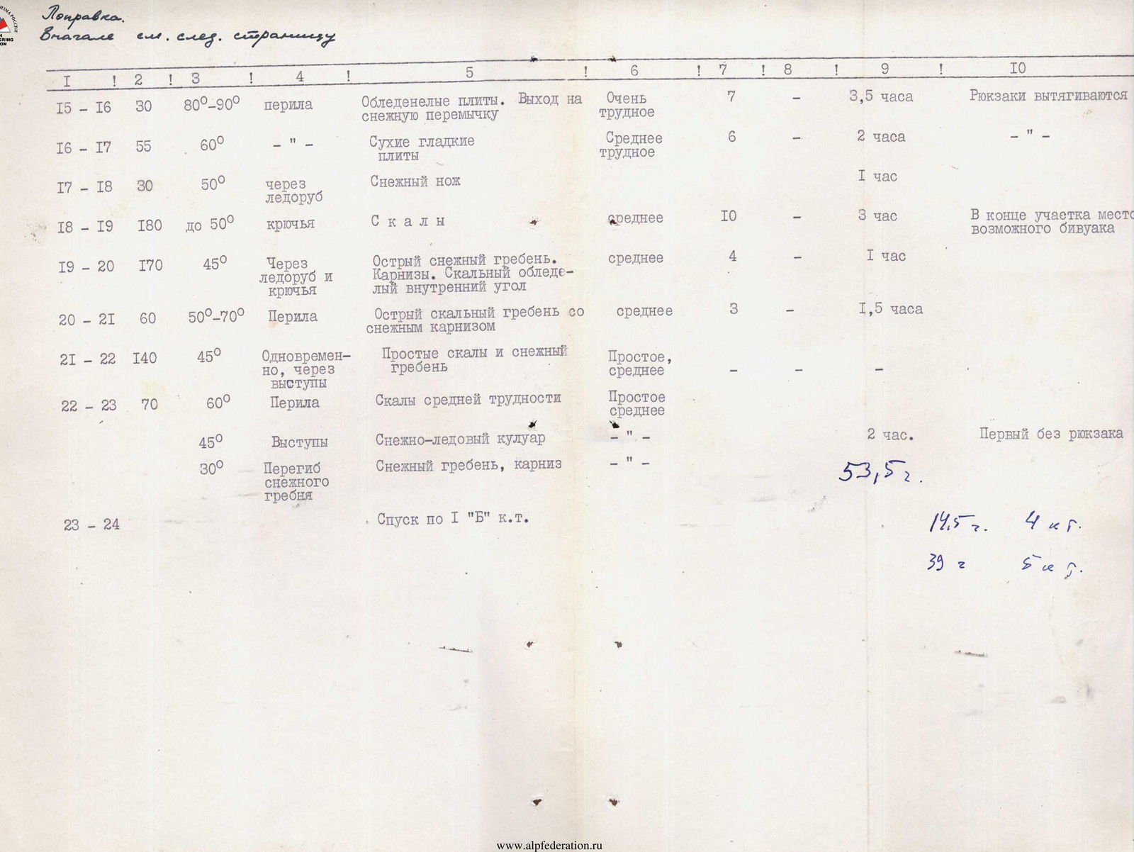
| R15–R16 | 30 | 80–90° | Railings | Icy slabs. Exit to a snowy isthmus | Very hard | 7 | 3.5 h | Backpacks are pulled out | |
| R16–R17 | 55 | 60° | — | Dry, smooth slabs | Medium hard | 6 | 2 h | — | |
| R17–R18 | 30 | 50° | Through ice axe | Snowy knife | — | 1 h | |||
| R18–R19 | 180 | up to 50° | Pitons | Rocks | medium | 10 | 3 h | At the end of the section, a possible bivouac site | |
| R19–R20 | 170 | 45° | Through ice axe and pitons | Sharp snowy ridge. Cornices. Rocky, icy inner corner | medium | 4 | 1 h | ||
| R20–R21 | 60 | 50–70° | Railings | Sharp rocky ridge with a snowy cornice | medium | 3 | 1.5 h | ||
| R21–R22 | 140 | 45° | Simultaneously, through protrusions | Simple rocks and snowy ridge | Simple, medium | ||||
| R22–R23 | 70 | 60° | Railings | Rocks of medium difficulty | Simple, medium | ||||
| 45° | Protrusions | Snowy-icy couloir | — | 2 h | First without a backpack | ||||
| 30° | Bending of the snowy ridge | Snowy ridge, cornice | — | ||||||
| R23–R24 | Descent via 1B category route |
TABLE OF MAIN CHARACTERISTICS OF THE ROUTE TO LAJUB PEAK VIA N-E WALL, 5B DIFFICULTY CATEGORY
| Date | Section | Steepness | Length (m) | Terrain characteristics | Difficulty | Condition | Weather conditions | Rock | Ice (in rock) | Bolt |
|---|---|---|---|---|---|---|---|---|---|---|
| 30.04 | R0–R1 | 65 | 200 | Snowy-icy gorge, ram's foreheads | U | Snow-covered, ice formed on the rock | Clear | 13 | 1 | 2 |
| R1–R2 | 70 | 180 | inner corner | U | — | — | 18 | — | — | |
| R2–R3 | 75 | 20 | blocks, wall | U | destroyed | — | 4/1 | — | 1 | |
| R3–R4 | 85 | 40 | overhanging blocks | VI | Monolithic | — | 6/4 | 2 | 2/1 | |
| R4–R5 | 80 | 30 | inner corner | VI | ice formed on the rock | — | 5 | — | — | |
| R5–R6 | 90 | 40 | cornice, chimney | VI | monolithic | — | 7/0 | 1 | 1 | |
| R6–R7 | 75 | 40 | slabs, inner corners | U | monolithic, snow-covered | — | 3 | 1 | — | |
| R7–R8 | 65 | 240 | slabs, ridge | IY | snow-covered | — | 6 | 2 | 1/1 | |
| 1.05 | R8–R9 | 50–55 | 380 | ridge | IY | cornices, destroyed rocks | Clear | 4 | 1 | — |
| protrusions | ice axe |
Departure — 6:00, stop for bivouac 21:30, climbing hours — 14, overnight stay on the ridge, sitting. Departure — 6:00, on the summit at 10:00, climbing hours — 4.
The time for preliminary processing of the lower part of the route, carried out on April 28 for 5 hours 30 minutes, is not included in the table.
General view of the route broken down into sections.
Brief Explanation
To the table of main characteristics
Processing day:
April 28. Under the route at 9:00 — departure from a group of large stones under the N-E wall, simultaneous movement along an avalanche-prone slope with a steepness of 45°, 300 m. Then traverse of a snowy-icy gorge to the left and upwards, 1.5 h. Upwards along snow-covered "ram's foreheads" 100 m — 2 h. Along a narrow, snow-covered ledge under overhanging rocks to the first night's bivouac site of the first ascenders. Total length of fixed ropes — 180 m, climbing hours — 5. April 30. At 6:00, we start passing the processed section. From the end of the ropes, 90 m to the left and upwards along a ledge covered with snow ( местами natёчный лёд). Then 90 m to the right and upwards along a ledge under overhanging rocks (snow, ice formed on the rock). 20 m of complex, destroyed rocks lead to the key section.
The key section — 40 m of complex rocks with small overhangs, 20 m ascent with traverses to the left, onto an overhanging ledge. Here is the third night's bivouac site of the first ascenders, a cairn. Under the cornice, in its left part, through a narrow chimney to a small ledge (40 m).
The length of the key section is 100 m. Further, through inner corners and small walls onto the ridge, initially very steep. Along the ridge to a place suitable for an overnight stay.
- We clear ice from the ridge.
- We set up a tent.
- Overnight stay is sitting.
May 1. Rise at 4:30, departure at 6:00. The overnight stay was cold. Movement along the ridge. Belay through protrusions, ice axes, on rocky sections — piton belay. A steep snowy pre-summit ascent. At 10:00 on the summit. Descent via a 1B category route to the base camp on Vardyvag Lake.