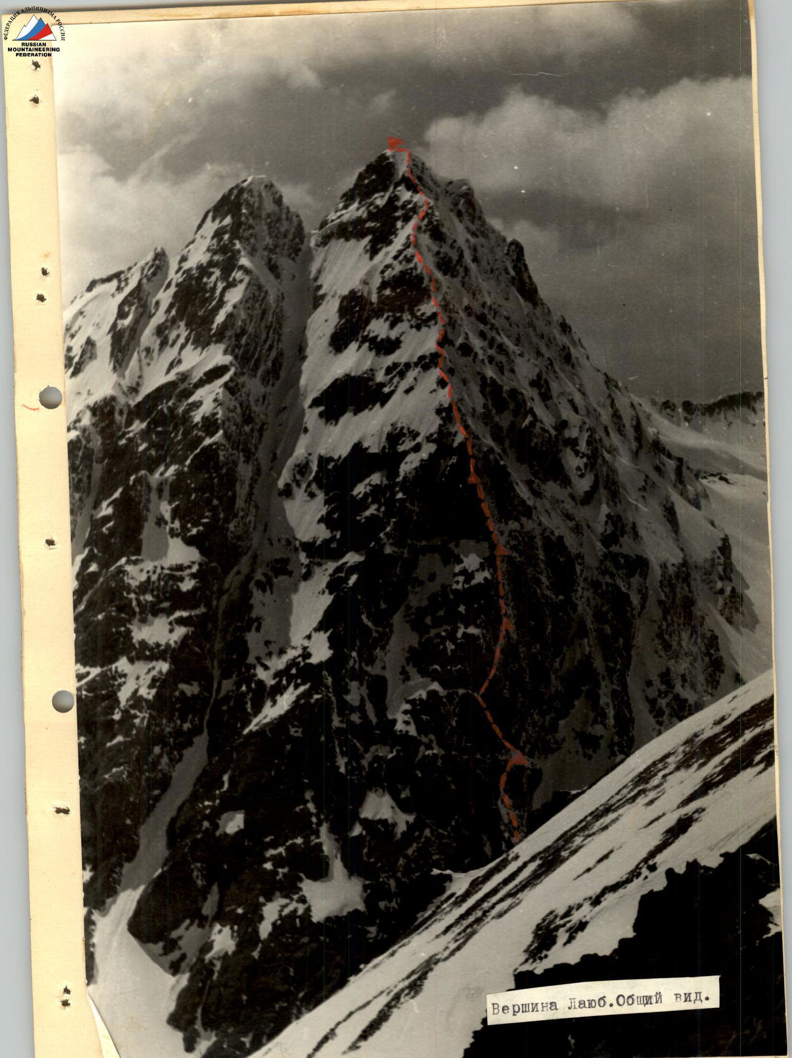
The route in question is laid out on the northeastern side of the main peak of Layub Vostochny.
The route can be conditionally divided into four parts:
- the lower part — a snowy slope, a snow-ice cone, rocks, below the "sheep's foreheads";
- the overhanging Northeast wall;
- the ridge of the counterfort;
- the rocky-snowy ridge of the summit.
The route is generally complicated by solid rocky formations, heavily snowed, and sheer sections covered with accreted ice.
The greatest difficulty is presented by a three-hundred-meter wall, with an overall steepness of more than 90°. The passage is facilitated by the presence of two giant internal corners crossing the wall in a zigzag from left to right, then from right to left (sections R4–R5, R5–R6, R6–R7) in the direction of the counterfort ridge.
The most challenging part is the upper section of the wall (sections R9–R18), composed of ice-covered slabs with a steepness of 80°–90° and in places overhanging up to 120° and corniced.
Further, the route passes along the complex steep rocks of the counterfort, transitioning into the rocky-snowy ridge of the summit.
This route throughout its entirety requires participants to have:
- good physical and technical preparation,
- application of high-level rock climbing techniques,
- use of a wide range of modern equipment.
The route is complicated by the fact that the sun illuminates the most difficult part of the path for only one and a half hours a day (from 5:30 to 7:00), resulting in intense cold.
List of participants
| № п/п | Surname I.O. | Sports qualification | Instr. qualification | Best ascents |
|---|---|---|---|---|
| 1. | ABARHARCHUK G.S. | 1st sports category | instructor | ULLU-TAU-CHANA 5B, DJAILYK 5A, p. SHCHUROVSKOGO 5A |
| 2. | MAZUROV O.N. leader | 1st sports category | junior instructor | USHGUULI 5B (first ascent), p. SHCHUROVSKOGO 5B, DJAILYK 5A |
| 3. | SALTYKOV V.M. | 1st sports category | junior instructor | DJAILYK 5B, p. SHCHUROVSKOGO 5A, DJAILYK 5A |
| 4. | SOROKIN A.G. | 1st sports category | junior instructor | ULLU-TAU-CHANA 5B, p. SHCHUROVSKOGO 5A, DJAILYK 5A |
Route description
First day May 3, 1973. Departure at 8:00
R0–R1. From a group of large stones under the Northeast wall, we simultaneously traverse a snowy slope with a steepness of 35°. 300 m, 30 min.
R1–R2. We traverse a snow-ice cone (60°) alternately, using the rocks on the right side of the couloir as cover. 120 m, 1.5 hours.
R2–R3. We emerge onto heavily snow-covered and ice-glazed rocks resembling "sheep's foreheads" with very few holds, climbing initially at a moderate difficulty, then hard, with a steepness of 65°–70°. 170 m; 16 pitons, including 2 bolt pitons; 4 hours.
R3–R4. Reaching an inclined internal corner (60° to the horizon) with an overhanging left side and an ice-glazed and snow-covered right side, with a steepness of up to 60°, we move up and to the right along it to a sharp, steep, short (8 m, 45°) snowy ridge supporting the wall. – Distance: 70 m – Number of pitons: 8 – Time taken: 4 hours Having cut away part of the ridge with ice axes, we organize a sitting bivouac.
Second day May 4, 1973. Departure at 5:00
R4–R5. From the bivouac site, we climb up and to the left along the inclined internal corner (60° to the horizon), heavily snow-covered and ice-glazed, beneath a rocky overhang. The right side of the corner overhangs, the left side has a steepness of more than 70°. 60 m, 12 pitons. The lead climber goes without a backpack. 2 hours.
R5–R6. The rocky overhang is bypassed on the left, very difficult climbing. The lead climber goes without a backpack. 5 m; 2 pitons; 1 hour.
R6–R7. Then, we climb up and to the right into an inclined internal corner. Initially, it has an inclination to the horizon of 30° — for a distance of 15 m, then up to 70°. The left side overhangs, the right side has a steepness of up to 60°. Much snow and ice. The lead climber goes without a backpack. 180 m, 23 pitons driven in, including 4 bolt pitons. 7 hours. A sitting bivouac is organized.
R7–R8. From the bivouac, a team of two sets out to scout the further route, leaving to the left ice-glazed, absolutely smooth slabs transitioning into an overhang and a three-meter rocky overhang. We emerge beneath an overhanging ledge ("The Forehead") cut by a wide ice-filled crevice. The steepness of the section up to "The Forehead" is 70°. 30 m; 5 pitons; 30 min.
R8–R9. Initially, the rocks of "The Forehead" overhang, then ease off to 80°. "The Forehead" is traversed using artificial aids (ladders). 20 m, 36 pitons, including 4 bolt pitons. From here, the descent to the bivouac takes 3 hours.
Third day May 5, 1973. Departure at 6:30
R9–R10. We exit along the previously scouted path onto sheer slabs, in places overhung with much accreted ice; to a small ledge capable of holding one person beneath a twelve-meter overhang (the point for receiving backpacks from under "The Forehead" — backpacks are pulled up with a lower belay). – 30 m – 42 pitons, including 3 bolt pitons – 8 hours Sections R8–R10 form a diamond shape, bounded on the right by a very steep couloir down which rocks are constantly falling. These sections are traversed by the lead climber using artificial aids, the rest move along the rope using étriers and jammers.
R10–R11. The overhang is bypassed on the right along a strongly destroyed vertical internal corner (80°–90°). Then, we exit onto a snowy ledge beneath an overhanging (120°) wall. Here, a sitting bivouac is organized. The section is traversed using artificial aids and free climbing. Backpacks were pulled through the overhang with a lower belay. – 15 m – 7 pitons – 4 hours
Fourth day May 6, 1973. Departure at 6:00
R11–R12. From the ledge, we climb up and to the right along an overhanging dry internal corner (100°) beneath a one-and-a-half-meter overhang (180°) using artificial aids (platforms, ladders). 20 m; 15 pitons; including 5 bolt pitons; 2.5 hours.
R12–R13. After the overhang, we climb a six-meter, overhanging, ice-glazed chimney 0.5 m wide with a "test piece" at the top, then exit onto the slabs of the counterfort. The section is traversed by free climbing. 3 pitons; 30 min.
R13–R14. Along the slabs at 45°–60° to a ledge — 15 m — the point for receiving backpacks from the bivouac. – 2 pitons – 30 min.
R14–R15. Along the overhanging, heavily ice-glazed and snow-covered rocks on the right side of the counterfort to a ledge beneath an overhang (very awkward — between the overhang and the ledge, the height is 1.5 m). Point for receiving backpacks. The section is traversed in places using artificial aids. – 40 m – 8 pitons – 4 hours.
R15–R16. We climb up onto the ridge of the counterfort, snow-covered, ice-glazed slabs (80°–90°) to a snowy saddle in the rocky ridge. Point for receiving backpacks. 30 m, 7 pitons, 3 hours 30 min. A sitting bivouac is carved out on a sharp snowy-icy section of the ridge.
Fifth day May 7, 1973. Departure at 6:00
R16–R17. Along dry, smooth slabs (up to 60°) on the left side of the ridge for 55 m to an overhanging section, which is traversed on the right (10 m) with an exit onto a snowy knife-edge. Backpacks are pulled up. 6 pitons driven in, 2 hours.
R17–R18. The snowy knife-edge at 50°, 30 m is traversed along the central part to the emergence of rocks, where a belay is set up (a rocky piton). The snow is loose, layered, covered with an icy crust. 1 hour.
R18–R19. Then, we exit onto rocks of moderate difficulty to a snowy ledge to the right of a vertical rocky slab (a convenient bivouac is possible) with a steepness of up to 50°, 180 m; 10 pitons; 3 hours.
R19–R20. Along a sharp snowy ridge (45°) for 170 m to the emergence of rocks on the left side of the counterfort. Then, up and to the right along a snowy knife-edge and two ice-glazed internal corners onto the rocky ridge (cornices) of the pre-summit pinnacle to a wide horizontal section of the ridge. Belay via ice axe, 4 pitons, 1 hour.
R20–R21. Descent down 10 m to bypass on the left a sharp rocky ridge with snowy cornices along dry slabs (50°–70°), then up and to the right along an icy couloir to a snowy shoulder of the pre-summit pinnacle. 60 m, 3 pitons, 1.5 hours.
R21–R22. Along a straightforward snowy ridge and straightforward rocks simultaneously onto the pre-summit pinnacle. 140 m, 1 hour.
R22–R23. Then, along rocks of moderate difficulty at 60° to the left into a rocky-icy couloir (45°), along it up and to the right to a snowy knife-edge (30°) supporting a snowy cornice. Having hacked through the cornice, we emerge onto the summit. 70 m, 2 hours. The lead climber goes without a backpack.
R23–R24. Descent via Category 1B.