Passport
Ascent
- Ascent class — technical.
- Ascent area, ridge — Caucasus, Krasnodar Krai up to Marukh pass.
- Peak, its height, ascent route — Layub, 2998 m via the eastern ridge.
- Proposed difficulty category — 4–6.
- Route characteristics: length of sections: R0–R1 — 450 m; R2–R3 — 230 m; R4–R5 — 640 m; R5–R6 — 320 m. elevation gain 1000 m; average steepness — 50°.
- Pitons driven — for belay — for exceptional circumstances. rock 58, ice —, bolted —.
- Number of climbing hours — 14.
- Number of overnight stays — none.
- Full name of the leader, participants, and qualification: leader — Krivov V.N. — 1st sports rank. participants — Chumak V.D. — II sports rank. Avakumyants E.A. — II sports rank. Azhinov V.M. — II sports rank.
- Team coach — Kisel Sergey Yakovlevich; Master of Sports.
- Date of departure on the route and return — May 10, 1977.
Photo of the general view of the summit (photo from the plateau below Chyornorechensky pass) Pre-summit GENDARME ↓ V. Layub
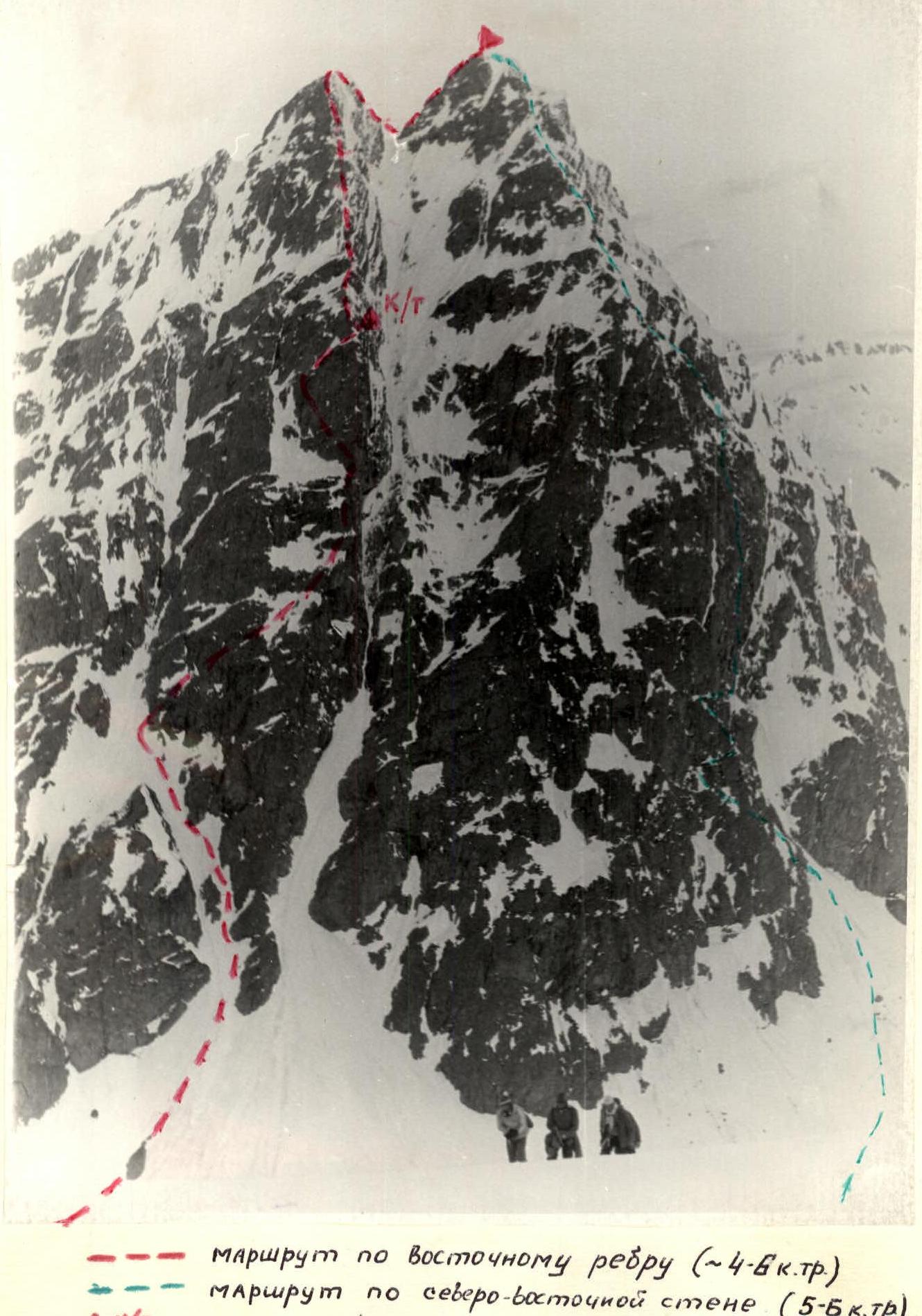 Route via the eastern ridge (~4–6 difficulty category)
Route via the north-eastern wall (5–6B difficulty category)
C/T — control tour
Route via the eastern ridge (~4–6 difficulty category)
Route via the north-eastern wall (5–6B difficulty category)
C/T — control tour
| Date | Designation | Average steepness in degrees | Length | Terrain characteristics | Difficulty | Condition | Weather conditions | Rock | Ice | Bolted |
|---|---|---|---|---|---|---|---|---|---|---|
| 10/V-1977 | R0–R1 | 40° | 260 | snow-ice | 2 | avalanche hazard | good | evenly, via ice axe | ||
| R1–R2 | 60° | 320 | wall type "ram's foreheads" | 4 | loose rocks, rime ice | — " — | 13 | — | — | |
| R2–R3 | 70° | 130 | wall | 5 | snowy | — " — | 12 | — | — | |
| R3–R4 | 30° | 60 | wall turning into a buttress | 3 | destroyed slabs | — " — | 2 and via ledges | |||
| R4–R5 | 70° | 40 | wall | 5 | snowy, loose rocks | — " — | 6 | — | — | |
| R5–R6 | 40° | 120 | wall-ridge | 4 | snowy, with rime ice | — " — | 4 and via ledges | |||
| R6–R7 | 30° | 100 | ridge | 3 | snowy | — " — | via ledges, simultaneously | |||
| R7–R8 | 60° | 120 | slabs | 4 | snowy, with rime ice | — " — | 4 and via ledges | |||
| R8–R9 | 50° | 80 | slabs | 4 | — " — | — " — | 3 and via ledges | |||
| R9–R10 | 20° | 30 | ridge, mixed rock | 2 | snowy | — " — | via ledges | |||
| R10–R11 | 75° | 80 | wall | 5 | rime ice | — " — | 8 | |||
| R11–R12 | 80° | 70 | wall | 5 | — " — | — " — | 6 and via ledges | |||
| R12–R13 | 20° | 40 | ridge | 2 | snowy | — " — | via ledges | |||
| R13–R14 | 50° | 70 | wall | 3 | snowy | — " — | via ledges | |||
| R14–R15 | 30° | 120 | ridge | 2 | snowy snow | — " — | — |
- Explanations for the table of the main characteristics of the ascent route. R0–R1. From the rocky island, left, past the base of the eastern ridge, enter the couloir, keeping to the right side. The couloir is snow-ice. Ascend to the snowy ridge coming from the left rocky island. R1–R2. From the snowy ridge, exit — steep "ram's foreheads" and move right-up (loose rocks, rime ice), through small mixed areas, exit right to the snow patch near the "Tooth", next to the ridge. R2–R3. Crossing the snow patch to the right — exit to the wall. On the wall, move left, approach the beginning of the couloir. Move left of the overhanging feathers. Stones constantly fall down the couloir to the left. R3–R4. The path to the ridge is along the right wall of the couloir; the couloir itself is rockfall-prone due to falling rocks on its left (by route) wall. Overnight stay possible on the ridge. Control tour in a pit on the wall. R4–R5. From the control tour, exit left onto the ridge. Difficult climbing. Loose rocks on the upper part of the wall. R5–R6. Wall-ridge, difficult climbing. R6–R7. Exit to the ridge shoulder from the left via the wall with rime ice. R7–R8. Along snowy slabs, along the ridge and slightly left of it. R8–R9. To the ridge shoulder. R10–R11. Wall with initially difficult climbing, into the middle slabs. R11–R12. Steepness 60° and further along the "mirror" (10 m, 85°) and then along the wall 75–80° to the ridge of the pre-summit gendarme. R12–R13. Along the easy ridge to the top of the pre-summit gendarme. R13–R14. Sports climbing (70 m) or rappel to the saddle before the summit. R14–R15. Exit to the summit along the snowy slope and snowy rocks.
Profile of the upper part of the route
 Route via the eastern ridge
C/T — control tour
Route via the eastern ridge
C/T — control tour