19 22
REPORT ON THE FIRST ASCENT TO THE SUMMIT OF KARDYVACH-UZLOVAYA VIA THE SOUTHEAST RIDGE ON OCTOBER 21–22, 1975, BY A GROUP FROM THE KUBAN REGIONAL COUNCIL OF THE "BUREVESTNIK" SPORTS SOCIETY
I. GEOGRAPHICAL INFORMATION AND SPORTS CHARACTERISTICS OF THE AREA
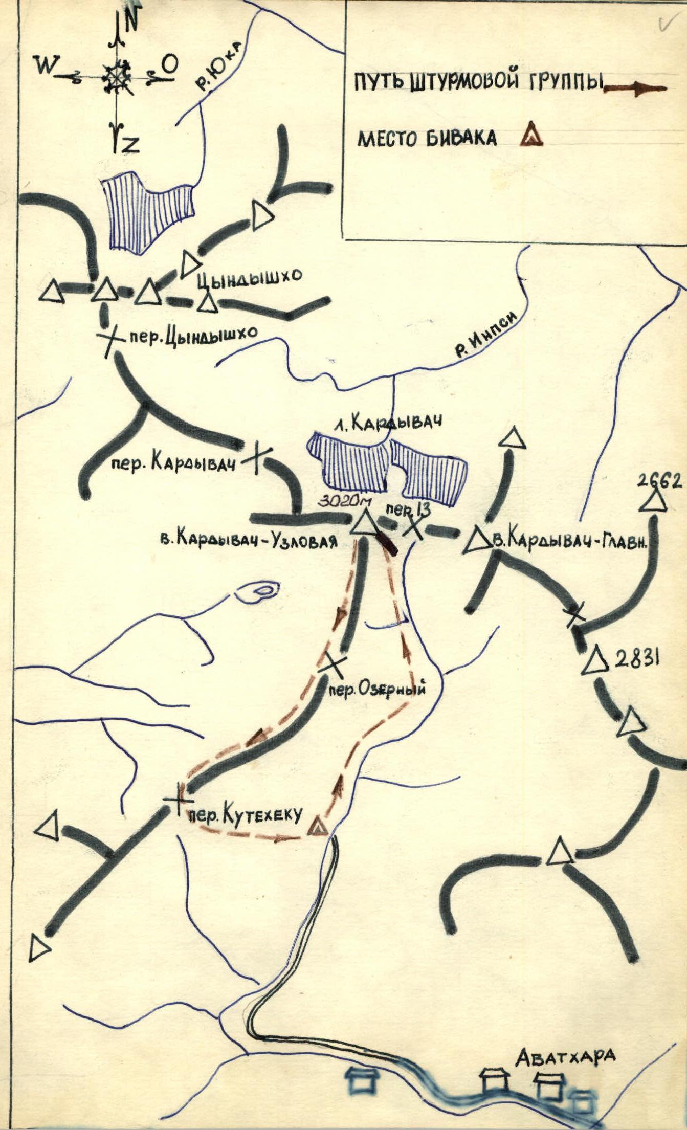
The Kardyвач lake area is located at the junction of:
- The Main Caucasian Range
- The Gagra Range
All peaks of sporting interest are part of the Main Caucasian Range. At the junction of the mentioned ranges stands the peak Kardyвач-Uzlovaya, elevation 3020 m. To its south lies the peak Kardyвач-Glavnaya, and to the north, there are five peaks of the Tsyndyshхо massif, Smidovich peak, and the peak Layub, situated in a spur of the Main Caucasian Range extending south towards the Gagra Range.
The elevation of the peaks in the area exceeds 3000 m above sea level, with the highest peak being Smidovich peak at 3359 m.
Below the southern slopes of the Layub peak lies the picturesque Kardyвач lake, and further up the gorge lies the Upper Kardyвач lake.
In the cirque between the peak Kardyвач-Uzlovaya and the Tsyndyshхо massif lies the Sineokoe lake, from which the Sineozernaya river flows, emptying into the Kardyвач lake.
The area is characterized by relatively short approaches and a large difference in altitude for the routes. Exploration began in 1968, and since then, the following routes have been traversed and classified:
- on Layub peak: 1B (via the couloir from the saddle), 2B (via the couloir through the subpeak), 5B (via the northern wall in winter)
- on Smidovich peak: 3A (via the ridge with Smidovich pass), 4A (via the counterfort from the Chernomorsky cirque)
- on the Tsyndyshхо peaks: 3B (to the main peak via the Western Counterfort), 4B (in winter, to North Tsyndyshхо via the North Wall)
- on Kardyвач Glavny peak: 4A (from the pass of the 13)
- on Kardyвач Uzlovaya peak: 2A (from the Kutateху pass)
All routes are combined. The area is promising for alpinism, with unclimbed traverses and wall routes of varying difficulty.
II. APPROACH TO THE BASE CAMP
From the town of Adler to the Ritsa lake - by bus; then to the Avadkhara settlement - 4–5 hours or 40 minutes by car (depending on the road conditions).
Rest - 1–1.5 hours, and then 3–4 km under the Southeastern slopes of the Kuta-Tekhu pass.
Overnight stay and organization of the base camp at the Koshey glade.
V. DESCRIPTION OF THE ASCENT TO KARDYVACH-UZLOVAYA PEAK VIA THE SOUTHEAST RIDGE
Group composition:
-
- Bashtinsky A.I. - 1st sports category, leader
-
- Smaglyukov S.E. - Candidate for Master of Sports, participant
-
- Abarbarchuk G.S. - 1st sports category, participant
-
- Mazurov O.N. - 1st sports category, participant
-
- Shishka N.F. - 2nd sports category, participant
-
- Cherkesov G.N. - 2nd sports category, participant
First day. October 21, 1975.
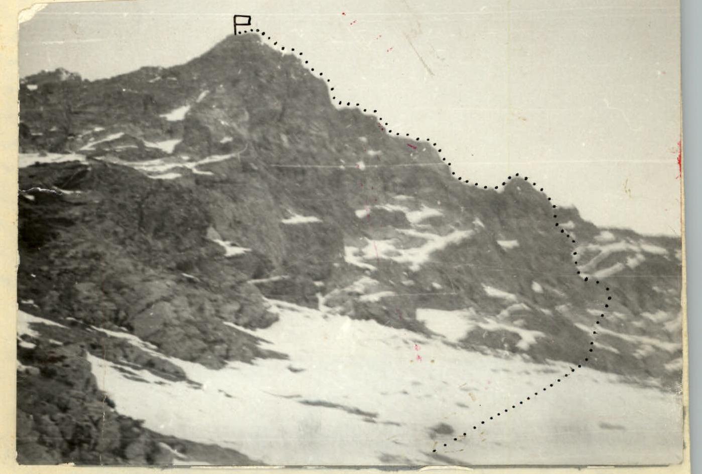
Departure from the base camp at Koshey glade at 4:00 AM to reach the upper cirque of the Avadkharka river by dawn. Initially, we follow the trail leading to the pass, then along the slopes of the pass - into the upper cirque under the snow-covered scree slopes descending from the ridge of the peak (see photo 1).
The route follows the right part of the South slope of the Southeast ridge. Travel time to the start of the route is 2–2.5 hours. R0–R1. Cross the scree slopes upwards to the right, leaving the gentle but rockfall-prone gullies to the left. Special attention! Helmets! Orient towards the slabs with black streaks. Up simple and moderately difficult rocks directly via a not clearly defined, winding internal corner to under a 5-meter steep wall. 60 m. 2 pitons. Average slope 25–30°. Time taken 30 minutes. R1–R2. The 5-meter wall is overcome directly, climbing of moderate difficulty. 3 pitons. Then 30 m upwards to a destroyed ledge and traverse 40–45 m left to the continuation of the internal corner. 80 m. 45 minutes. R2–R3. Up the right side of the internal corner to a 7-meter steep wall, climbing of increased difficulty. The wall is passed via an inclined crack with few holds. 3 pitons. 30 m. 45 minutes. R3–R4. Directly upwards 35–40 m, then up to the right 1.5 ropes into a rock depression, emerging onto the ridge under the 1st "gendarme". Section length 100 m, average slope 40°. 30 minutes. Control cairn. R4–R5. Ascend the "gendarme" wall via a large flake 3 m, then right along a ledge and up - a small wall leads to the ridge. Section length 40 m. 4 pitons. Ropes. 1 hour. R5–R6. Simple, broken ridge. Simultaneous climbing. 1 rope. Short snow bridge, then steep ridge with snow bridges and small walls: the 1st is bypassed on the left via a ledge, the 2nd and 3rd - directly. Alternate belay on ridge outcrops. Section length 4 ropes. Average slope 35°. Time taken 2 hours. R6–R7. A snow-covered, simple ridge leads to the summit. Steep drops to the right! Simultaneous movement. Section length 6 ropes. Overall slope 25–30°. Time taken 1 hour. On the left slope of the pre-summit ridge, a possible bivouac site. The group reached the summit at 13:00. Descent from the summit via the Western ridge to the Kuta-Tekhu pass. Following the classified route 2A category.
VI. TABLE OF MAIN ROUTE CHARACTERISTICS
Route length - 710 m, including complex sections - 180 m. Steepness of complex sections - 60°.
| Section | Time taken | Section length | Average steepness | Number of pitons | Section characteristics |
|---|---|---|---|---|---|
| R0–R1 | 30 min | 60 m | 30° | 2 pcs. | Scree slopes |
| R1–R2 | 45 min | 80 m | 35° | 3 pcs. | Difficult rocks. 5 m wall |
| R2–R3 | 45 min | 30 m | 35–40° | 3 pcs. | Difficult rocks. 7 m wall |
| R3–R4 | 30 min | 100 m | 45–50° | 2 pcs. | Rocks of moderate difficulty |
| R4–R5 | 1 hour | 40 m | 40° | 4 pcs. | "Gendarme" of the ridge |
| R5–R6 | 2 hours | 160 m | 35° | - | Simple ridge with three walls |
| R6–R7 | 1 hour | 240 m | 30–25° | - | Simple ridge |
6 hours 30 minutes. 710 m. 14 pcs.
VII. GENERAL CONCLUSION ON THE ROUTE
During the ascent via the Southeast ridge to Kardyвач-Uzlovaya peak, the group kept records and photographed the sections.
The traversed route is an interesting combined route. The difficulty lies in the diverse rock terrain. The descent path via the snow (mainly) route 2A category with three "sporting" descents also increases the overall difficulty.
The route is objectively safe and logical. When assessing the category, the group compared the route with known classified routes such as:
| Peak | Category of difficulty |
|---|---|
| 1. Layub East | 2B category |
| 2. Irik-Chat Central | 2B category |
| 3. Germogenov peak | 3A category |
| 4. Trezubets peak | 2B category |
| 5. Eastern Gvandra | 2B category |
The group believes that in terms of difficulty and length, the route corresponds to the 2B category.
The 2B category route via the Southeast ridge of Kardyвач-Uzlovaya peak can be recommended for training ascents by highly qualified mountaineering groups and for educational and sports ascents by mountaineers of the 3rd to 4th stages of training.

X. PHOTOGRAPHIC MATERIALS OF THE ASCENT
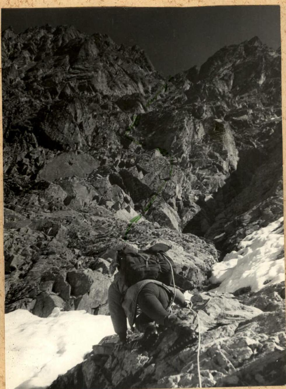
Photo 1. Section R0–R1–R2–R3.
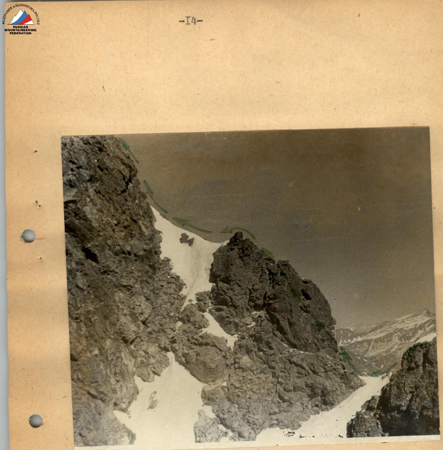
Photo 4. Section R5–R6.
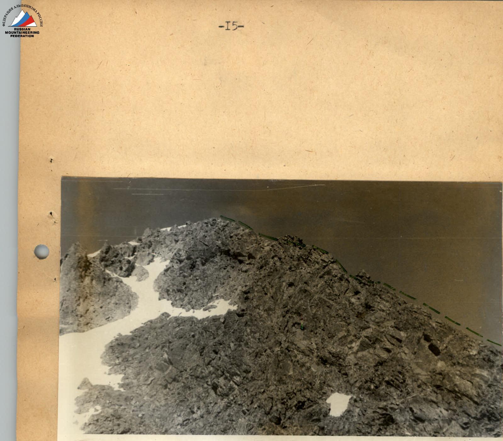
Photo 5. Pre-summit ridge.