Description
The route of the first ascent to the peak Uzlovaya - Kardyvach via the Western ridge by the group of the Krasnodar regional Federation of alpinism DSO "Burevestnik" in May 1972.
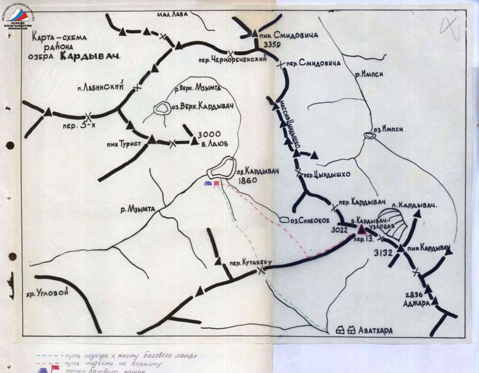
Approach to the initial bivouac
From the city of Adler to the Risha lake - by bus. Then to the Avadhara settlement 4-5 hours walk or 30 minutes by car (depending on road conditions). Overnight stay. Departure from the Avadhara settlement at 4-5 am to reach the south-eastern slopes of the Kuta-teku False pass before sunrise. 1.5-2 hours walk. Then ascent along the pronounced rib directly along the route. Snow slopes with a steepness of 25-30°. After ascending to the ridge, turn right to the Kuta-teku pass. Ascent to the pass takes 3-4 hours. Possible bivouac site. Then descend from the pass along a snowy slope with a steepness of 45°. Two ropes. Then the slope is 20-25°. Descend to the forest. At the entrance to it, turn left and traverse the slope. Follow the stream leading to the Kardyvach lake. Convenient and safe bivouac site.
From the Kardyvach lake bivouac, head south through the forest, along the left (orographic) bank of the Lagyernaya river, to a wide snowy chute. Up the chute and then left to a vaguely expressed rib leading to the western ridge of the Uzlovaya - Kardyvach peak. Reach the ridge at a point without a cornice. From the base camp 1.5-2 hours. R0-R1.
Description of the ascent route
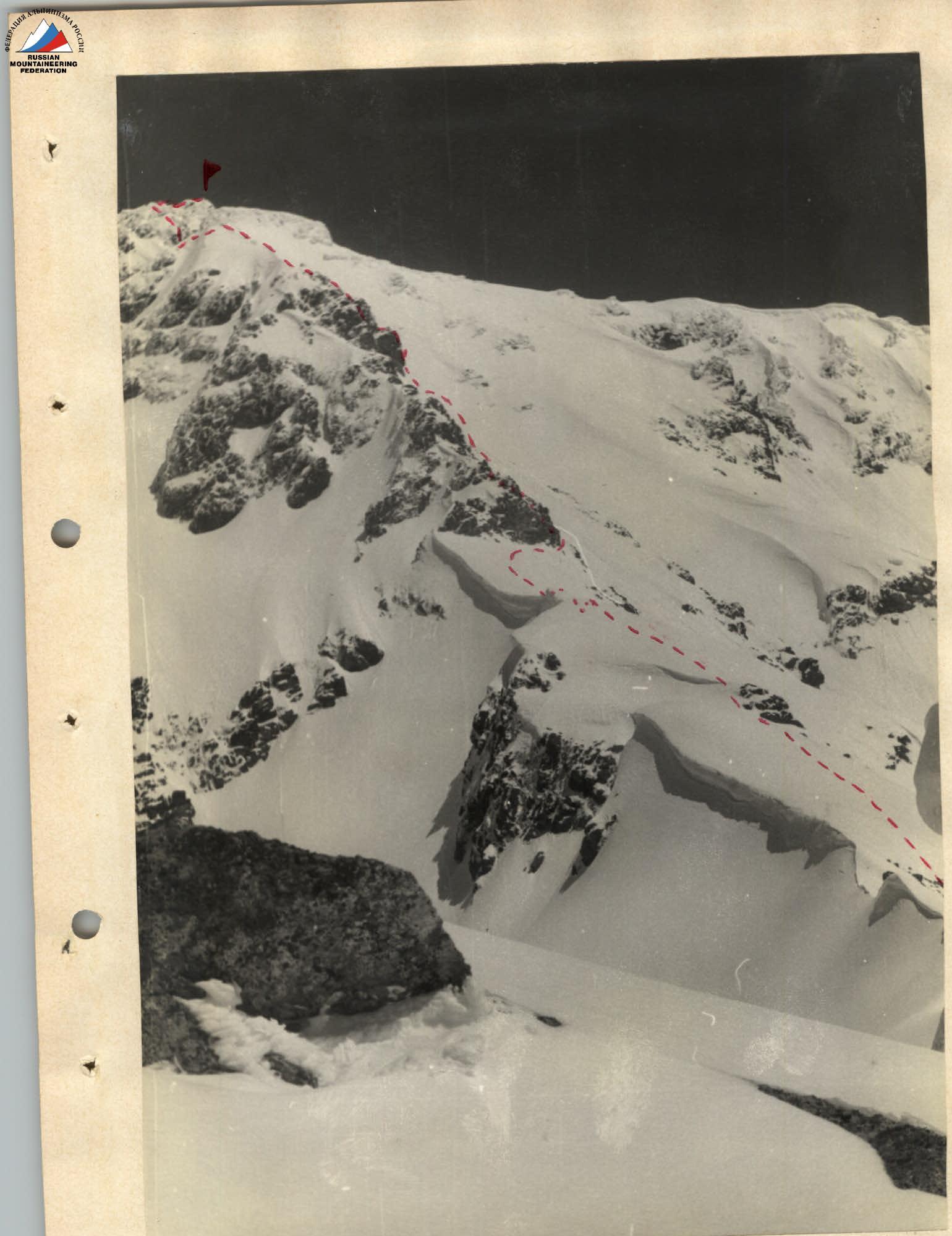
Then left along a steep (40-45°) snowy ascent (60 m), turning into a ridge. Along the snowy ridge (cornices on the left!), bypassing rock outcrops on the right, we approach the first wall. The wall is bypassed on the left along a steep (up to 50° in the upper part) snowy chute. Then traverse right to snow-covered rocks. Along the rocks (5-6 m) - exit to the ridge. Insurance is alternating through an ice axe. R1-R2.
After the wall, a snowy wide ridge 200-250 m turns into a narrow one (60-80 m, photo 3). Then the ridge widens again. Simple rocks are encountered. Movement is simultaneous. R2-R3.
Then descent along a very narrow snowy ridge 40 m, with a steepness of up to 40° in the upper part. Then the ridge becomes gentler and leads to the second rocky wall. Movement is alternating, insurance through an ice axe. R2-R3.
The wall, 12-15 m high, is bypassed on the right along the snow (photo 4) 15-20 m to an internal corner leading left up. Along the 3-meter internal corner, and then along simple 9-10 m rocks - exit to the ridge. Along the ridge to a rocky ledge and further along a very narrow 8-10-meter snowy ridge to the third wall. Movement is alternating, insurance through ledges. From the ridge, along the rocks, we descend 5-6 m down and then up the rocks to a ledge. Along the ledge left 3 m and straight up 6 m to the ridge. The steepness of the wall in the lower part is 65-70°, in the upper part 50-55°. The left part of the wall is gentle, but has a slab-like structure with very few grips. Insurance through ledges. One rock hook is driven in. R3-R4.
Then along a simple ridge, which after 200-250 m sharply descends 15-20 m, we come to a steep 40° snowy slope. Up the slope 30 m to a heavily snow-covered rocky wall (photo 6). Along the ledge, we move right 2-3 m, then straight up along the outer corner. The steepness of the first 4 m is 60°, the next 7-9 m - 45-50°. R4-R5.
Then along a heavily broken ridge 50-60 m - exit to the summit. Movement is simultaneous.
Descent via the ascent route
Time taken for sections: R0-R1 - 1.5 hours R1-R2 - 1 hour R2-R3 - 2.5 hours R3-R4 - 2 hours R4-R5 - 1.5 hours
Total route length is 850-900 m. Height difference from the base camp is 1200 m.
Route conclusion
The route was completed by a group of instructors from the Krasnodar regional Federation of alpinism DSO "Burevestnik" consisting of:
- KORZHOV N.I. - 2nd sports category - leader
- GERASYUK A.K. - CMS - participant
- SALTYKOV V.M. - 1st sports category - participant
- KOVALENKO Y.I. - 2nd sports category - participant
The route is combined, ridge. In complexity, it is not inferior to such routes as:
- peak Vilsa and peak Shulgina - 2A category of complexity;
- Kogutoy-Bashi - 2A category of complexity;
- Via-Tau - 2A category of complexity.
The group believes that the route corresponds to the 2A category of complexity.
Route recommendations
- Number of participants - 4-12 people
- Initial bivouac - Kardyvach lake
- Departure time from bivouac - 3-4 hours
- Equipment for 4 people (group): a) main rope - 2 × 40 m b) rock hooks - 4-6 pcs. c) rock hammers - 2 pcs. d) expendable carabiners - 4 pcs.
- Possible overnight stay sites: a) on the summit b) before the second wall
Photo 2. General view of the route