Ascent Passport
- Region: Caucasus, Arkhyz area, section 2.1 ECTM 2013
- Peak 3201 m (Karadash Yu.), via the eastern wall
- Proposed category: 4B, first ascent
- Route type: rock climbing
- Route height difference: 290 m
Route length: 330 m. Length of sections with category V difficulty: 88 m. Average steepness of the main part of the route: 52°
- Pitons left on the route: 0, including bolted pitons: 0, use of artificial climbing aids (ITOs): 0
- Team's climbing hours: 9.5 hours
- Team leader: Shamalov V.P., Master of Sports of Russia
Team members:
- Ivanova-Efimova Elizaveta, 2nd sports category
- Olennikov Sergey, 1st sports category
- Petrov Sergey, 2nd sports category
- Sklyarova Evgeniya, 2nd sports category
- Coaches: Lobachev E.A., Candidate Master of Sports
Shamalov V.P., Master of Sports of Russia
- Departure from camp on the glacier: May 8, 2013, at 7:00 AM
Route started: May 8, 2013, at 7:30 AM. Reached the summit: May 8, 2013, at 5:00 PM. Returned to camp on the glacier: May 8, 2013, at 6:00 PM. Returned to base camp in Orlenok valley: May 8, 2013, at 9:30 PM. Descent from the summit: via the SE wall, route category 4A.
- Organization: Polytechnic sports club, St. Petersburg.
- Report responsible: Shamalov V.P.
Email and phone: va_le_ra-sh@mail.ru, +7 921-955-94-13.
General Photo of the Summit
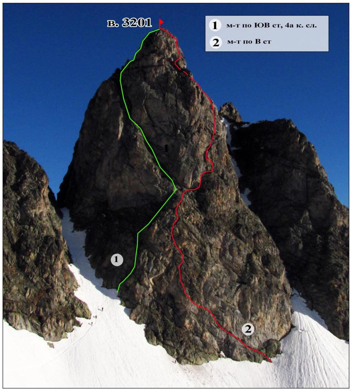
The team's route on the eastern wall on May 8, 2013, view of the route from the snowfield at an altitude of about 2900 m
Route Profile
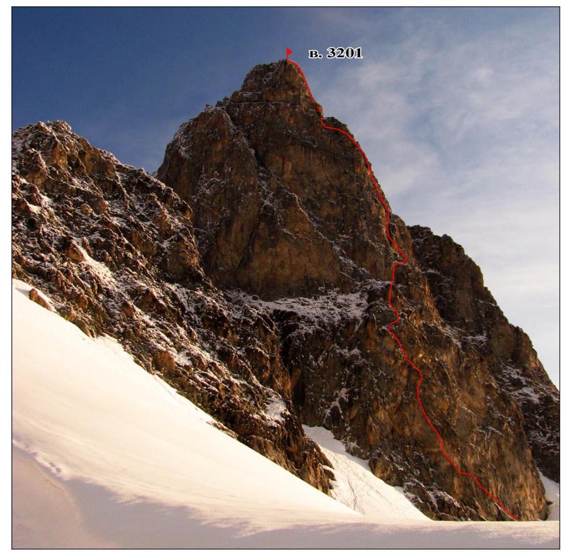
View from the left on the route to Karadash Yu. peak via the eastern wall, August 8, 2013, altitude about 2900 m
Drawn route profile
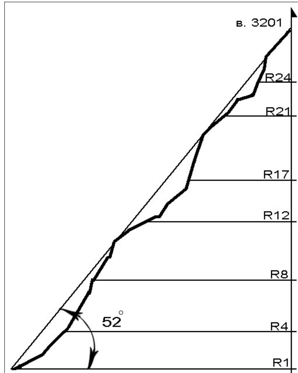
Photo Panorama of the Area
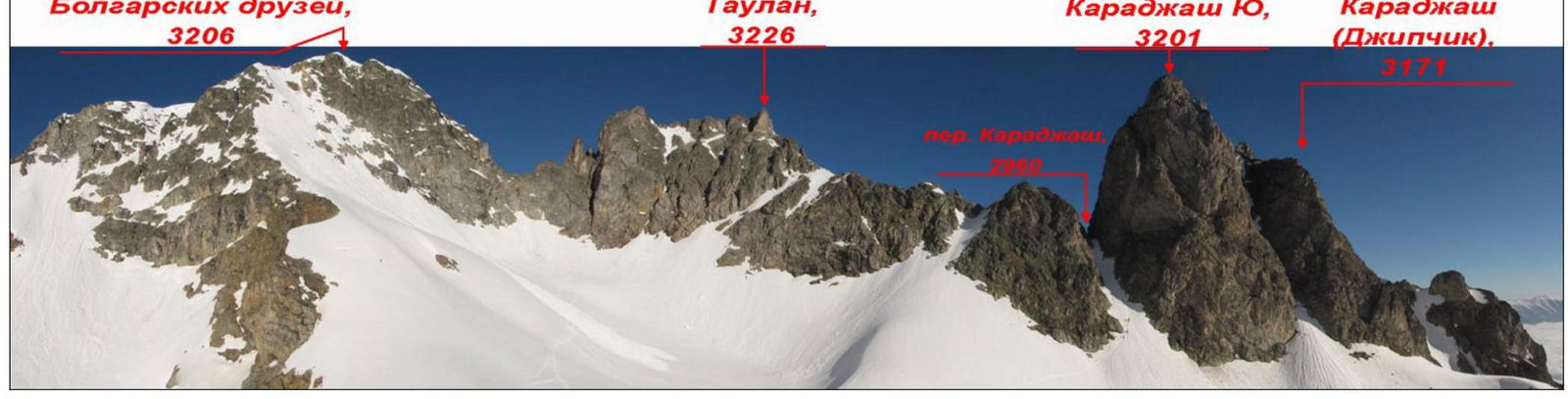
View from the Gammet-Chat river valley
05/08/2013
Area Overview
The Arkhyz area is the central part of the Western Caucasus, a vast mountainous region with a total area of about 145,000 square kilometers. The highest peaks in the Arkhyz area are:
- Pshish (3780)
- Sofia (3640)
- Amanauz-Bashi (3530)
- Pshysh (3502)
Reaching the Arkhyz settlement is not difficult: by train to Nevinnomyssk station, then by bus to Zelenchukskaya stanitsa, and finally by bus to Arkhyz settlement. We traveled by hired car from Nevinnomyssk station to Taulu glade.
The area is part of a border zone, so it's necessary to obtain permits a month in advance. To do this, the necessary information is sent to the Border Guard Directorate of Cherkessk, and it's indicated that the permits will be collected at the Arkhyz border post (located 2 km from the settlement, on the road to Taulu glade).
Contacts: pu.kcherkes@fsb.ru - email of the Border Guard Directorate
http://fsb.ru↗ - sample application and other information
The peaks in the area are not inferior in technical difficulty and beauty to the peaks of popular mountaineering areas, only losing in height. Approaches to the peaks are short and convenient, which is also a positive factor.
Route diagram on Karadash (Yu) peak, 3201 m, via the eastern wall in UIAA symbols
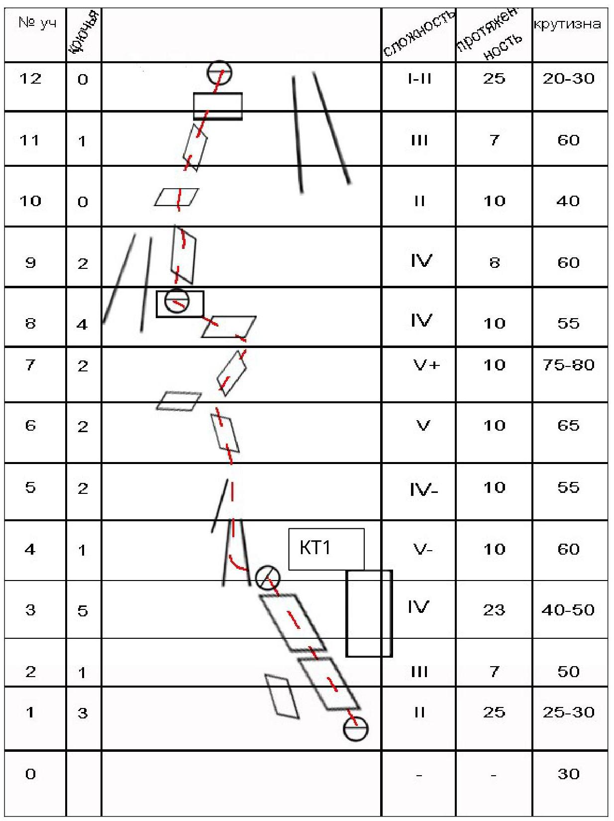
| № | y4 | ||||||
|---|---|---|---|---|---|---|---|
| 26 | 1 | 75-80 | |||||
| 25 | 0 | V | 10 | 65 | |||
| 24 | 0 | V | 15 | 65 | |||
| 23 | 1 | V | 8 | 70 | |||
| 22 | 0 | I | 15 | 10 | |||
| 21 | 2 | II–III | 7 | 60 | |||
| 20 | 4 | II–III | 10 | 40-50 | |||
| 19 | 2 | IV | 15 | 60-70 | |||
| 18 | 2 | V | 10 | 85 | |||
| 17 | 2 | V | 15 | 65 | |||
| 16 | 1 | II | 5 | 20 | |||
| 15 | 5 | KT2 | IV | 25 | 65 | ||
| 14 | 1 | II | 10 | 30 | |||
| 13 | 3 | I | 10 | 20 |
Descent via route 4A
Technical photo of the route
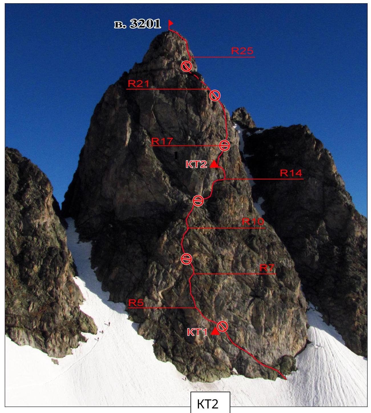
Karadash (Yu) peak, 3201 m.
Route Description and Tactical Actions of the Team
On May 7, 2013, the group climbed a category 4A route on peak 3201 m via the SE wall and spent the night in a tent on a snowy slope approximately 300 m southeast of the wall.
On the evening of May 7:
- approached the eastern wall,
- conducted route reconnaissance,
- carried equipment.
On May 8 at 7:30 AM, the group approached the eastern wall and began working on the route.
The route to peak 3201 m via the eastern wall starts in the right part of the wall, under a large overhanging slab.
R1–R3. From the snowfield, a grassy ledge goes up to the left. Initially, the movement is very easy, but after 20–25 m, the steepness increases, the ledge narrows, and more complex climbing begins. After 50 m from the start of the route, there is a station on a narrow ledge under an overhang, which is also the 1st control point.
Sergey Petrov worked as the lead climber for the entire route, while the other participants ascended using the rope.
R4–R7. From the cairn, a small couloir leads to a rock rib on the left, then continues upward via moderately complex rocks. After 25–30 m:
- to the right, upward via more complex rocks;
- then a short traverse to the left to a convenient ledge.
R8–R11. Initially, upward via moderately complex rocks, then the steepness decreases, and climbing becomes easier. After 25 m, there is an exit to a simple inclined ledge.
R12–R16. From the ledge, movement is upward, bypassing large gendarmes. Behind them, it's necessary to:
- turn to the right,
- exit upward to a small rock rib,
- then to the left, into an inclined chimney.
In the middle part of the chimney, a second control cairn was left on a placement. After 45 m from the large ledge (R11), there is an exit to an inclined ledge, where a sufficiently convenient station was made.
In the upper half of the route, we encountered abandoned rappel loops, likely left by another group that descended to the large ledge. R17–R20.
Movement is directly upward via steep and complex rocks. There are occasional small vertical and slightly overhanging sections, up to 2 m.
After 40 m, the wall becomes less steep. The rope length is slightly insufficient to reach a convenient ledge, so the station is made on an inclined slab.
R21–R23. Initially, to the left and upward, a few meters via a steep internal angle. Then, along a convenient ledge, about 15 m. It would have been possible to make a station on the ledge, but, fearing that the rope would not be long enough to reach the summit, Petrov climbed another 10 m to the right and upward via an internal angle and made an inconvenient station on a small outcrop.
R24–R27. To the right and upward, initially via complex slabs, then via a steep and complex internal angle. After 25 m, there is an exit to a simple, gentle ridge, and after another 25 m, the summit.
We reached the summit around 5:00 PM on May 8, 2013, and found our own note left there on May 7 during the ascent via the SW wall, category 4A route.
We descended to the tent left under the route in 1.5 hours, via the category 4A route, and on the same evening, through Karadash pass, returned to the base camp in Orlenok gully.
General Remarks on the Route
The route climbed is significantly more complex than the route to the same summit via the SE wall. Participant S. Olennikov suggested classifying it as category 5A, as it appears to be a category more complex than the SE wall route.
The team leader's opinion is to classify the route via the E wall as category 4B, but within the category, it will be more complex than average.
The route via the SE wall should either be:
- downgraded to category 3B, or
- considered within the category as below average in complexity.
It's logical to consider combining these routes - it's possible to climb the lower part from one route and the upper part from the other, switching to the other route on the ledge at section R11.
Such combinations would logically be evaluated as good and sufficiently complex category 4A routes.
Overall, the route via the E wall is quite safe, with reliable terrain. It's necessary to be cautious on sections R22–R23 to avoid dropping rocks on a neighboring route if another group is working on it. (Photo 1.) Start of the route
