Karajash Peak (3171) Route: via the northern ridge Complexity category: 4A cat. (Combined) Leader: V. Babkin Western Caucasus, Arkhyz, Orlenok ravine, mountain range (ridge) Karajash Section in KMGV – 2.1. E-mail – ZHUR58@RAMBLER.RU
Report
On the first ascent of the mountaineering route to the Karajash peak (3171) "Via the northern ridge 4A cat. (combined)". At the mountaineering event: Climbing competition by NP "Club of Northern Travels 'Sauk-Pai'" — "Cup of Victory" (class First Ascents) 2013 (class "First Ascents").
Region: Karachay-Cherkess Republic Mountain country: Western Caucasus Gorge: Orlenok ravine Ridge (mountain range): Karajash Peak: Karajash (3171) Route: Via the northern ridge Complexity level: 4A cat. (rocky)
Prepared by: V. Babkin, Zhuravlev S. V. May, 2013
Western Caucasus. Arkhyz. Orlenok ravine.
Peaks: Karajash (3171).
Route: "Via the northern ridge"
Complexity level: 4A cat. (Combined)
Photo-profile of the northern ridge from the Orlenok peak
East, May 2013
Description of the peak
The Karajash peak (3171) is a nodal peak of the Karajash mountain range (on old maps — ridge). It is located on the territory of the North Caucasus Federal District of the Russian Federation, in the Karachay-Cherkess Republic, Arkhyz mountain region (Orlenok ravine), between the Psyish and Sofia rivers. The Karajash peak (3171) is a pronounced mountain of the Karajash ridge, easily identifiable from the Taulu clearing, located at the confluence of the Sofia river into the Psyish river. The name of the peak is official, marked on the geographical maps of the Russian Federation (M:1 cm = 1 km), translates from the Karachay language as "Black Prince".
Description of the route
The route "Via the northern ridge" is a long route with an abundance of diverse rocky sections of varying complexity levels. A distinctive feature of the route is the constant change in terrain, requiring mastered skills in applying various movement techniques and organizing insurance on rocky terrain.
Equipment
To complete the ascent for a sports group of 2 people on the route, the following special equipment is necessary:
- Personal — standard.
- Group:
- Main rope 9 mm — 2 × 50 m
- Rock hammer — 1 pc.
- Ice axe — 1 pc.
- Rock pitons — 10 pcs. (including 4 Krasnoyarsk anchor pitons)
- Nuts — 12 pcs.
- Friends (large) — 6 pcs.
- Ice screws — 0 pcs.
- Quickdraws — 20 pcs.
- Slings — 15 pcs.
- Carabiners — 20 pcs.
Approach
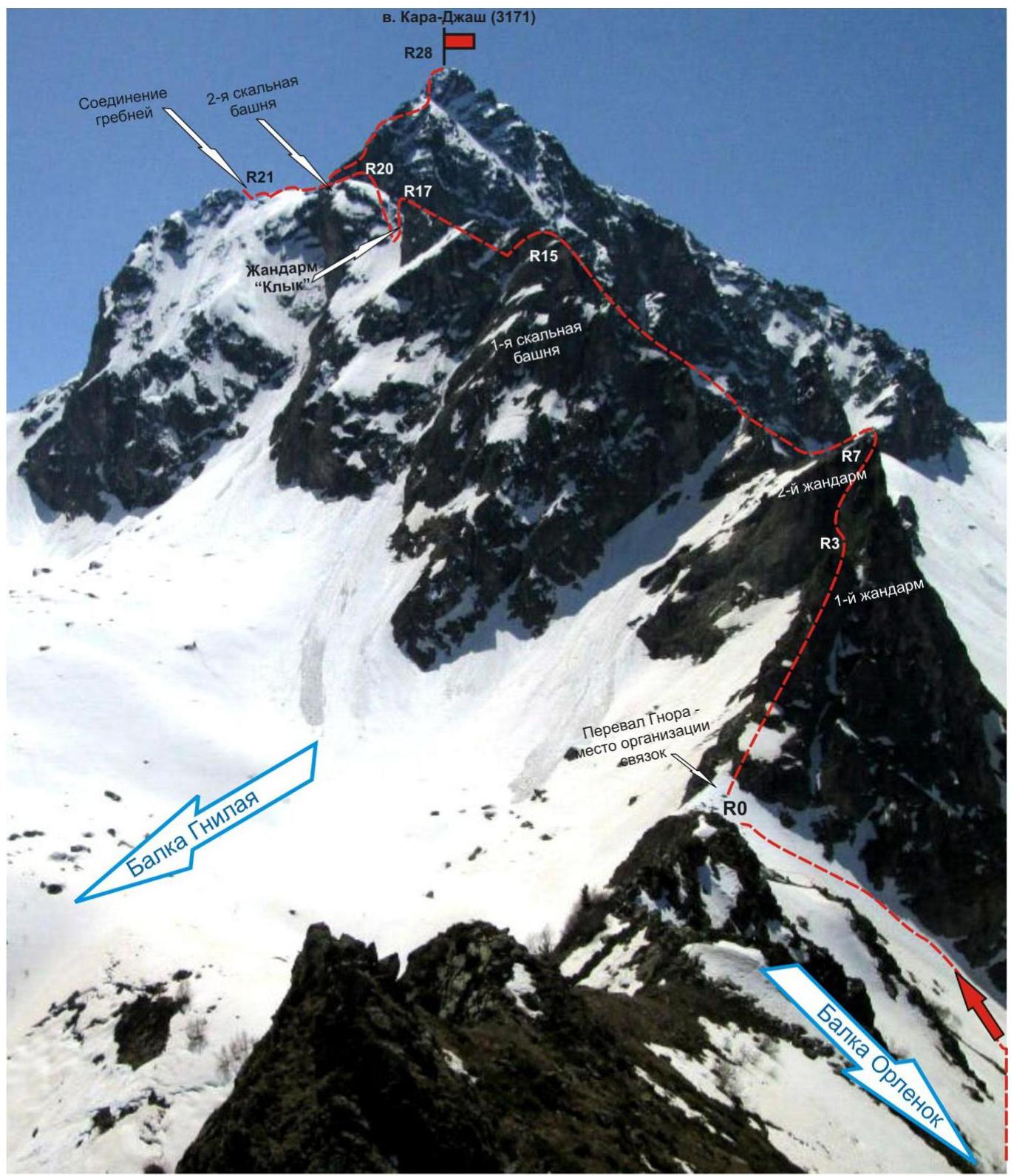
The ascent starts from a bivouac in the upper circus of the Orlenok ravine. The approach to the bivouac in the upper circus is not complicated: from the Taulu clearing, cross the Sofia river by bridge and ascend along the Orlenok ravine — first along a logging road, then along a clearly visible trail.
The circus is well-defined, in winter and spring it is snowy, in summer it is overgrown with high-altitude vegetation with two beautiful lakes among small birch and pine groves. From the Taulu clearing, it takes 1.5–2 hours to ascend to the circus. The circus has convenient places for tents, with water (streams) and dry areas, freed from snow by the end of April — beginning of May. The height of the bivouac near the lake above sea level is 2200 m. In the panorama of the circus, the Karajash peak is dominant and easily identifiable. The northwestern ridge is clearly visible. The approach from the campsite to the start of the route — to the Gnora pass, takes about an hour.
Technical part
Immediately after ascending via scree (snow) to the Gnora pass and approaching the foot of the counterfort along the ridge, the leader should put on rock shoes and prepare a full set of rock climbing equipment. After organizing the rope team on the Gnora pass:
- Along the destroyed rocky ridge, then along a rock shelf, approach the wall with a cleft, leading to the northwestern ridge (short — 10 m).
- Ascend the wall with a cleft to the first gendarme.
- Further along the ridge of varying complexity, approach the second gendarme.
- The second gendarme, like the first, is overcome "head-on".
- After the second gendarme, descend to the ridge and move along a complex rocky ridge.
- In some areas, the ridge is traversed in a hanging position on anti-stops.
- Traversing the ridge, approach the first rock tower.
- Ascend the rock tower via an inclined wall.
- Further descend and move along the ridge under the gendarme "Klyk".
- The gendarme is not bypassed, it is overcome "head-on" via complex rocks.
- From the gendarme, rappel to a grassy shelf.
- The shelf is wide, a convenient place to set up a tent.
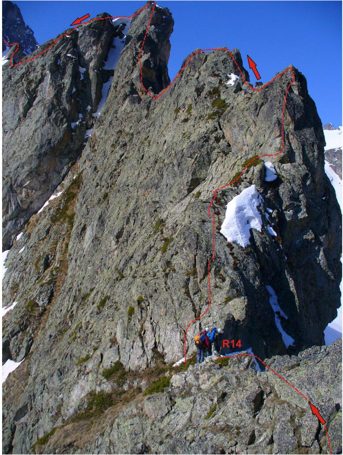
- Along the shelf, approach the second rock tower, under the route's crux.
The crux of the route is a complex rock wall-monolith, requiring passage of a section (5 m) on artificial aids (A1) in its middle part. The upper part of the crux is a smoothed, but sloping, weakly expressed rocky ridge of medium complexity.
After passing the crux, move along a snowy, destroyed rocky ridge. The section is long, requiring concentration of attention, as the rocky terrain and climbing techniques constantly change.
Along the ridge:
- Reach the junction of the northern and northeastern ridges.
- Then descend to a saddle.
- Along the northern ridge — via the 2B cat. route, ascend to the Karajash peak (3171).
The peak is a rocky pyramid-shaped, well-defined.
Descent from the peak
The descent from the peak is done via the 2B cat. route — first along the northern ridge to the saddle separating the Karajash and 2900 peaks (Karajash Northeastern). Further along the eastern couloir down to the Gammesh-Chat river valley. Then along a trail along the river, it is possible to descend to the Sofia river valley, cross the river on a log bridge, and descend along a dirt road to the Taulu clearing.
It is possible to return to the Orlenok ravine through the Lipetsky pass (transition to the Gnilaya ravine), then through the Gnora pass to the Orlenok ravine.
Passport
- Section number according to KMGV — 2010 — 2.1. Western Caucasus, mountain region — Arkhyz, Orlenok ravine, mountain range (ridge) Karajash
- Name of the peak: Karajash
- Height: 3171
- Route: via the northern ridge
- Complexity category: 4A cat.
- Character of the route — combined
- Height difference of the route: 750 m
- Route length: 1580 m
- Length of sections of the highest cat.:
Sections:
- 1 cat. — 4 sections — 350 m
- 2 cat. — 8 sections — 805 m
- 3 cat. — 11 sections — 230 m
- 4 cat. — 5 sections — 115 m
- 5 cat. — 5 sections — 80 m
- 6 cat. — 0 sections — 0 m
- Steepness of the route — 55°, on technically complex sections up to 90°.
- Pitons used: Total used on the route: rock pitons — 11, nuts — 47, stationary pitons — 0, A1 — 1 point, removable pitons — 0. Left on the route: total — 3; including stationary pitons — 0, nuts — 0.
- Exit to the route — 4:00, May 3, 2013. Reach the peak — 17:00, May 3, 2013. Return to BL — 20:30, May 3, 2013.
- Team's moving hours: — 16 h 30 min.
- Leader: V. Babkin (CMS, instructor-methodologist 2nd category, Yekaterinburg). Participants: V. Zakharov (2nd sports category, Moscow)
- Coach: V. Babkin (CMS, instructor-methodologist 2nd category, Yekaterinburg).
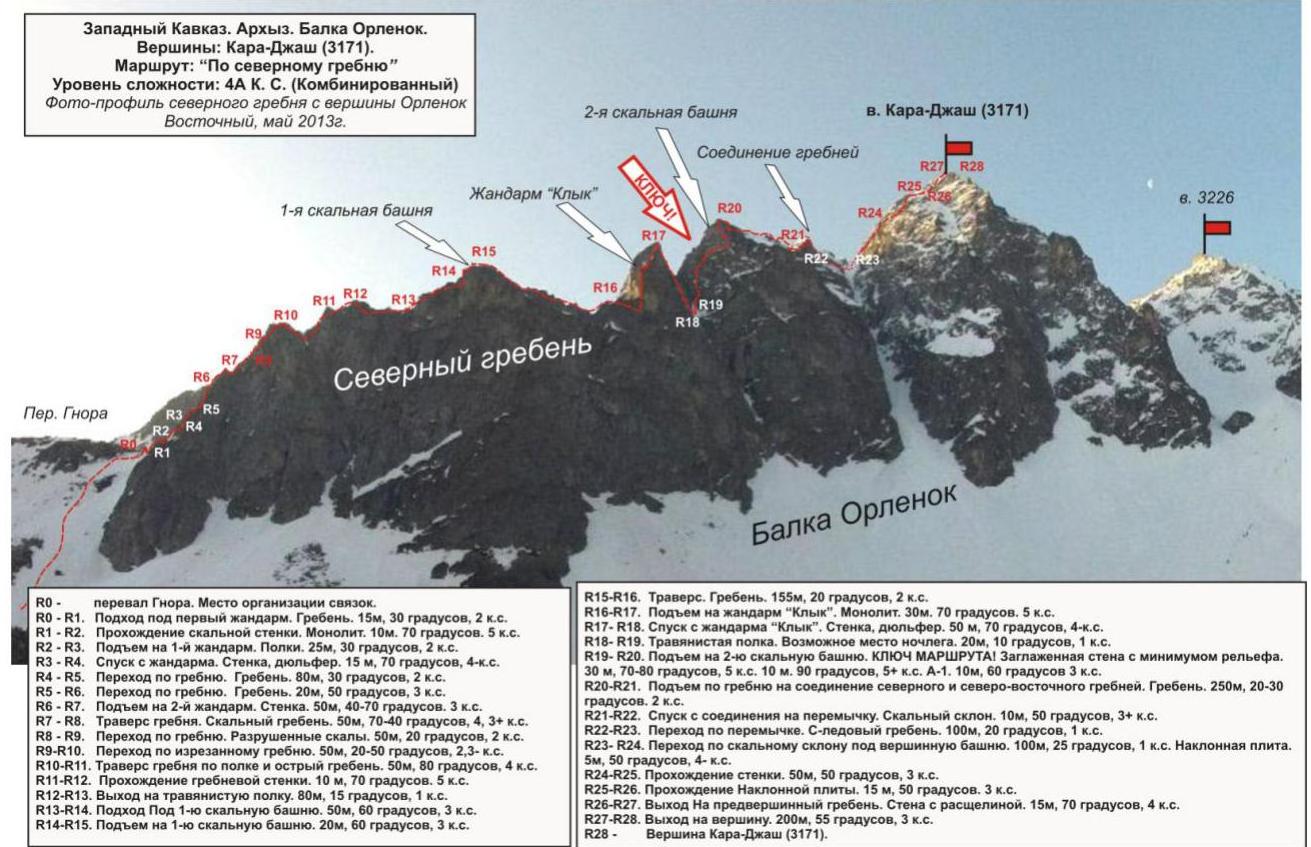
Western Caucasus. Arkhyz. Orlenok ravine.
Peak: Karajash (3171).
Route: "Via the northern ridge"
Complexity level: 4A cat. (Combined)
Technical photo with route drawing and main landmarks
Photo from the north, from the Orlenok peak. May, 2013
Western Caucasus. Arkhyz. Orlenok ravine.
Peak: Karajash (3171).
Route: "Via the northern ridge"
Complexity level: 4A cat. (Combined)
Scheme in UIAA symbols.
Western Caucasus, Arkhyz, Orlenok ravine. Karajash mountain range. Peak Karajash (3171). Route: "Via the northern ridge". 4A (Combined) (approximately). (table of natural obstacles of the route — appendix to the scheme in UIAA symbols)
| section | length | steepness | terrain character | cat. | number of pitons/nuts |
|---|---|---|---|---|---|
| R0 – start of the route – Gnora pass | Convenient place for organizing a rope team. | ||||
| R0–R1: approach to the gendarme | 15 | 30 | destroyed rocky ridge | 2 | Rock — 0/0, Nuts — 0/0 |
| R1–R2: passage of a rock wall | 10 | 70 | rock wall | 5 | Rock — 2/0, Nuts — 2/0 |
| R2–R3: ascent to the 1st gendarme | 25 | 30 | shelves | 2 | Rock — 0/0, Nuts — 0/0 |
| R3–R4: descent from the gendarme | 15 | 70 | descent with rope pull-through | 4 | Rock — 0/0, Nuts — 0/0 |
| R4–R5: movement along the ridge | 80 | 30 | rugged rocky ridge | 2 | Rock — 0/0, Nuts — 0/0 |
| R5–R6: movement along the ridge | 20 | 50 | steep rocky ridge | 3 | Rock — 0/0, Nuts — 4/0 |
| R6–R7: ascent to the 2nd gendarme | 20 / 30 | 70 / 40 | rock wall-monolith. Passed "head-on" | 3 / | Rock — 0/0, Nuts — 6/0 |
| R7–R8: traverse of the ridge | 20 / 30 | 60 / 75 | complicated climbing along smoothed rock monoliths | 3+ / 4 | Rock — 2/1, Nuts — 6/0 |
| R8–R9: movement along the ridge | 50 | 20 | destroyed section of the ridge | 2 | Rock — 0/0, Nuts — 0/0 |
| R9–R10: movement along the ridge | 20 / 30 | 50 / 20 | rugged rocky ridge | 3 / 2 | Rock — 0/0, Nuts — 2/0 |
| R10–R11: traverse of the ridge along a shelf, passage of an acute ridge | 50 | 80 | monolithic acute ridge (traverse from the right along the path) | 4 | Rock — 0/0, Nuts — 6/0 |
| R11–R12: ascent to the ridge via a wall | 10 | 70 | rock-monolith | 5 | Rock — 3/0, Nuts — 0/0 |
| R12–R13: exit to a grassy shelf | 80 | 15 | grassy shelf (emergency descent from the route to the Gnilaya ravine – two rappels) | 1 | Rock — 0/0, Nuts — 0/0 |
| R13–R14: approach to the first rock tower | 50 | 60 | rocky massif with an abundance of microrelief | 3 | Rock — 0/0, Nuts — 4/0 |
| R14–R15: ascent to the first rock tower | 20 | 60 | rocky massif with an abundance of microrelief | 3 | Rock — 0/0, Nuts — 0/0 |
| R15–R16: traverse of the ridge | 155 | 20 | ridge section of dense rocks | 2 | Rock — 0/0, Nuts — 0/0 |
| R16–R17: ascent to the gendarme "Klyk" | 30 | 70 | rock-monolith with a minimum of microrelief | 5 | Rock — 2/0, Nuts — 4/0 |
| R17–R18: descent from the gendarme "Klyk" | 50 | 70 | rappel with rope pull-through | 4 | Rock — 0/0, Nuts — 0/0 |
| R18–R19: passage along a grassy shelf. | 20 | 10 | grassy shelf, possible place for overnight stay. | 1 | Rock — 0/0, Nuts — 0/0 |
| R19–R20: ascent to the 2nd rock tower of the northwestern ridge. CRUX! | 20 / 10 / 10 | 60 / 90 / 40 | smoothed wall with a minimum of relief | 5 / 5+ A1 / 3+ | Rock — 4/2, Nuts — 6/0 |
| R20–R21: exit to the junction of N and N-E ridges | 250 | 20 | rugged rocky ridge | 2+ | Rock — 0/0, Nuts — 0/0 |
| R21–R22: descent from the junction of ridges via rocks to a saddle | 10 | 50 | strongly destroyed rocky slope | 3 | Rock — 0/0, Nuts — 0/0 |
| R22–R23: passage along a snow-ice ridge to a saddle. | 100 | 20 | snow-ice slope. | 1 | Rock — 0/0, Nuts — 0/0 |
| R23–R24: approach to the peak tower of Karajash peak (3171) | 150 / 5 | 25 / 50 | rocky ridge, slabs, inclined shelves | 1 / 4 | Rock — 0/0, Nuts — 3/0 |
| R24–R25: passage of a rocky slab of the peak Karajash (3171) | 15 | 50 | wall-monolith | 3 | Rock — 0/0, Nuts — 3/0 |
| R25–R26: passage of a slab | 15 | 50 | inclined slab | 3 | Rock — 0/0, Nuts — 1/0 |
| R26–R27: passage of a wall with a cleft and exit to the pre-peak ridge | 15 | 70 | wall with a cleft | 4 | Rock — 0/0, Nuts — 2/0 |
| R27–R28: passage of the pre-peak ridge and exit to the peak | 200 | 55 | rocky ridge | 2+ | Rock — 0/0, Nuts — 3/0 |
| R28 – peak Karajash (3171) | The peak is well-defined. The tour is easily found. | ||||
| DESCENT | along N ridge and E couloir to Gammmesh-Chat valley (via 2B cat. route) |
Total:
Route length — 1580 m. Average steepness — 55°, on technical sections — up to 90°. Terrain character — combined.
Sections by complexity categories:
- 1 cat. — 4 sections — 350 m
- 2 cat. — 8 sections — 805 m
- 3 cat. — 11 sections — 230 m
- 4 cat. — 5 sections — 115 m
- 5 cat. — 5 sections — 80 m
- 6 cat. — 0 sections — 0 m
Used — 11 pcs., left — 3 pcs. pitons, nuts — 47 pcs., left — 0 pcs.
Western Caucasus. Arkhyz. Orlenok ravine. Peak Karajash (3171)
Route: "Via the northern ridge" 4A cat. (combined)
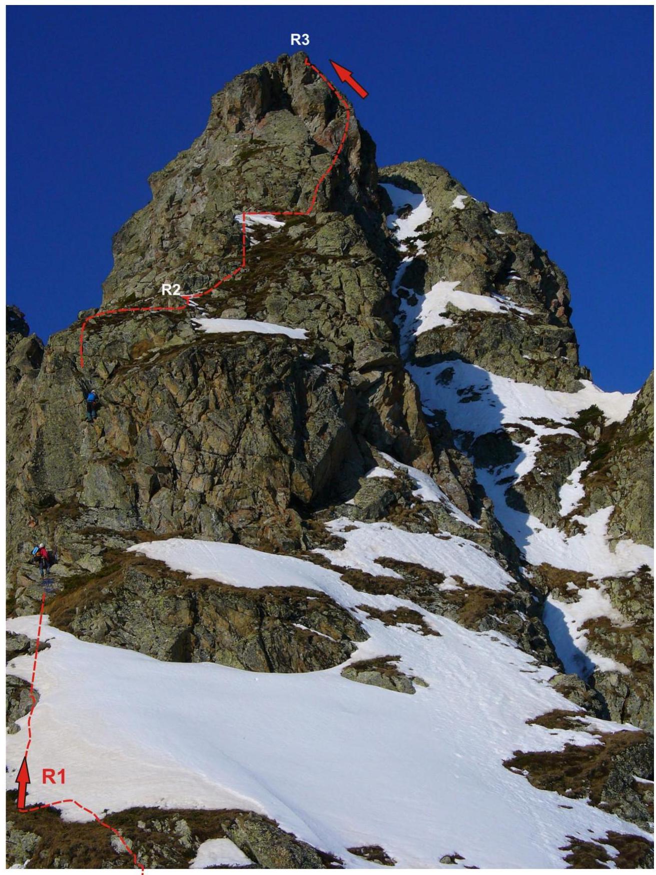
Section R0–R3 — ascent to the first gendarme of the northern ridge. Passage of the first rope length of the technical part of the route.
Photo from the Gnora pass — start of the technical part of the route.
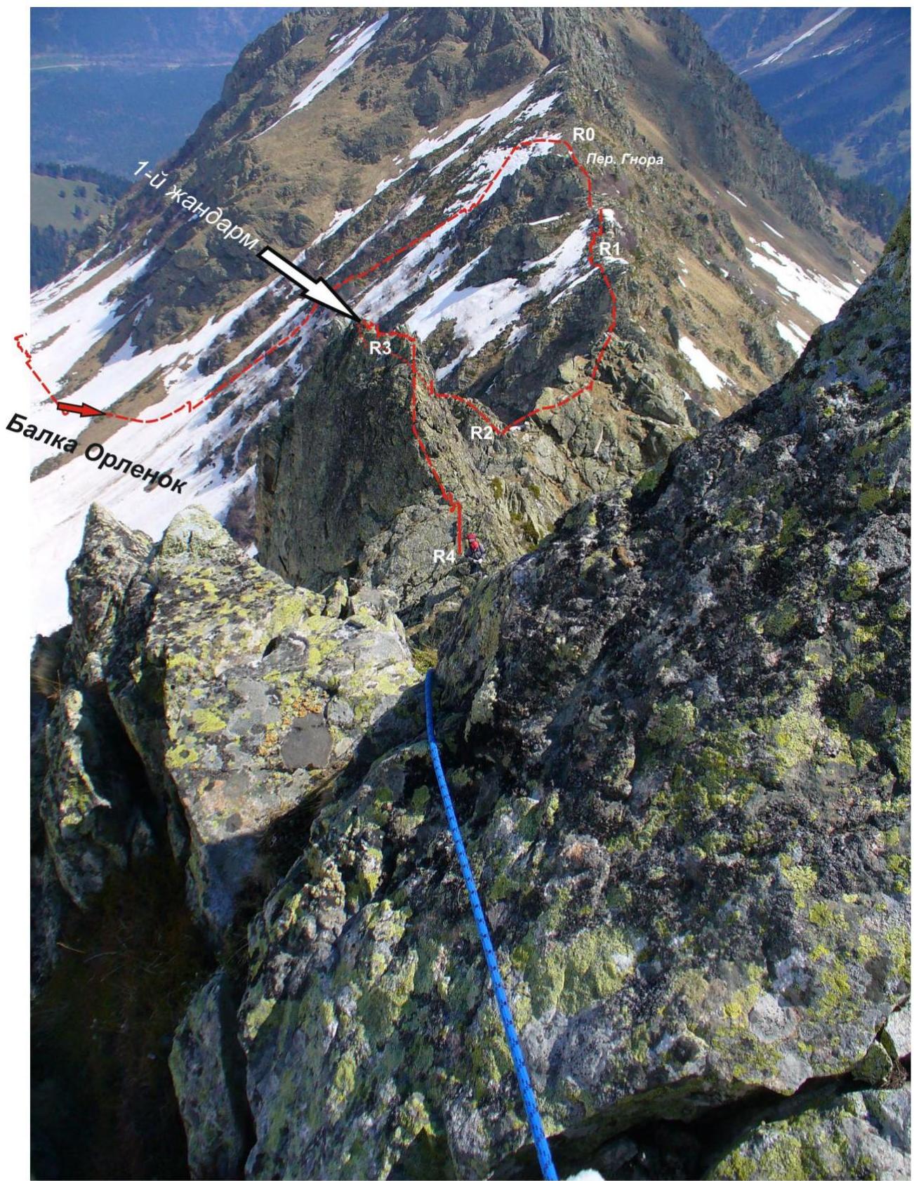
Western Caucasus. Arkhyz. Orlenok ravine. Peak Karajash (3171)
Route: "Via the northern ridge" 4A cat. (combined)
Section R0–R4 — ascent to the first rock tower
Photo from the northern ridge towards the Gnora pass — start of the technical part of the route. May, 2013
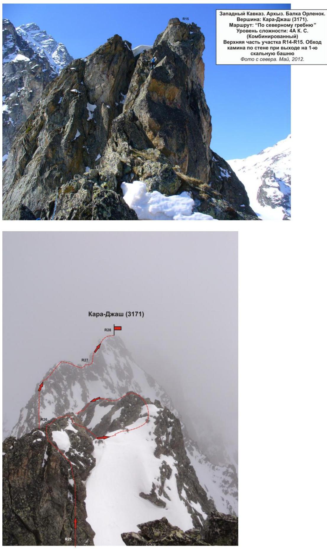
Western Caucasus. Arkhyz. Orlenok ravine.
Peak: Karajash (3171).
Route: "Via the northern ridge"
Complexity level: 4A cat. (Combined)
Photo of the peak from the north, from the pre-peak ridge, May, 2013