ASCENT DOCUMENT
283 PV February 22, 1983 55 2149
| ASCENT CLASS | Rock |
|---|---|
| ASCENT AREA | Western Caucasus, North-Western spur of the Sofiyskiy ridge between Psysh and Sofiya river valleys. |
| PEAK, ROUTE | XIX Congress of VLKSM (first ascenders' proposal) via South-Eastern couloir and North-Eastern ridge. |
| PROPOSED GRADE | 2B |
| ROUTE CHARACTERISTICS | Combined (snow and rock), absolute height difference — 450 m. |
| PITONS DRIVEN | 5 (during ascent) |
| DURATION (TRAVELING HOURS) | 8 |
| NUMBER OF NIGHTS SPENT | not required on the route |
| ASCENT LEADER | Zaporozhchenko E.V., CMS |
| PARTICIPANTS | Yanchenko V.V., 1st Cat. |
| Gavrilov I.V., 1st Cat. | |
| Kosyakov P.I., 1st Cat. | |
| Smerchanskiy V.A., 1st Cat. | |
| TEAM COACH | Master of Sports of the USSR Popov V.P. |
| DEPARTURE AND RETURN DATES | May 2, 1982 |
The unnamed peak 3171 m (absolute mark according to the state topographic plan M 1:25000) is located at the extreme North-Western end of the Sofiyskiy ridge. It is clearly visible as a separate peak from various places in the Sofiya, Psysh, and Bol. Zelenchuk river valleys (see photo 1, 2, and 3). To the east of it is Zaimov-peak (3011 m), first ascended by the Stavropol krai sports committee climbers in January 1982.
The peak 3171 m, as the object of the first ascent in honor of the XIX Congress of VLKSM, was chosen during reconnaissance group outings in November and December 1981, as well as in January 1982.
The most acceptable route for the first ascent seemed to be the route via the steep, wide snow couloir of South-Eastern exposure, the relative avalanche safety of which was assessed during the last reconnaissance on April 30, 1982, by a snow and avalanche specialist from the Vysokogorny Geophysical Institute, Candidate of Geographical Sciences A. Runich.
The nearest classified peak — ~3200 m, category 1B difficulty, is located to the South-West of the Stolicny pass.
The approach to the start of the route can be made via two options:
- from the "Syrzavod" clearing up the Kasha-Eshek river
- from the "Sofiya" refuge up the Gammash-Chat river
The first option is questionable in terms of avalanche safety and, at least until the beginning of May, it is unacceptable. The second option is more preferable in this regard.
Groups (first ascenders and subsequent ones) used the approach from the "Sofiya" refuge.
The following describes this option:
- From the "Sofiya" refuge (abs. mark 1830 m) through the snow (it melts in the refuge area on May 10–20) up the Gammash-Chat river to the first ledge.
- The ascent to the first ledge is made from the right through avalanche cones descending in winter from the peak named after Zaimov.
- At the top — "Zapятая" lake.
- To the right of the lake (covered with snow until the end of May) — along the snowy slope to the base of the second ledge.
- At the right part of the base — a wide snow couloir.
- Through the couloir — to the upper inclined part of the ledge.
- Turn right and with a ~20-degree ascent to the site of the assault camp in the immediate vicinity of the start of the route.
Overnight stay — on snow, at the base of the rocky spur extending from the peak 3206 m (see diagram). Absolute mark 2700 m. From the "Sofiya" refuge to the overnight stay 4–6 hours walking, depending on the snow conditions.
ROUTE DESCRIPTION
From the overnight stay, first with a slight ascent (~100 m), then descent (~100 m) to the base of the south-eastern wide snow couloir, ~800 m.
Absolute mark — 2720 m. The steepness of the couloir is from 35° at the beginning to 50° when exiting to the saddle. Section R0–R1. In rope teams, on snow (lying on dense firn at the beginning of May), alternating movement straight up to the saddle having an absolute mark 2915 m. The saddle is narrow, on the side of Bazarnaya-Chat river, above steep walls, going deep down, a powerful cornice! 1 hour 30 minutes. Section R1–R2. Along the left part of the ridge of north-eastern orientation (to the right are cornices) alternating movement. After 5 × 40 m to the right and up exit to the narrow watershed part of the ridge through rocks covered with snow. The steepness of the first 4 ropes ~35°, the last ~50°. Absolute mark — 3030 m. 1 hour. Further, the path is blocked by a 25-meter wall. Section R2–R3. There are two approximately equal options for overcoming the wall. First. To the left and up 5 m and through a vertical inner corner after 20 m exit to the knife-like watershed part of the ridge. Second. Straight ahead, with the use of one artificial support point, exit to the same knife-like ridge. In both options, mandatory piton insurance. Difficult climbing (IV+). Holds are small, smooth. Rock — granite. After a small shoulder, there are still about 20 m of 75-degree, simpler rocks. 1 hour 30 minutes. Section R3–R4. Sharp ridge. After 40 m of 60-degree rocks, turn left, after another 40 m — a 5-meter (small) gap, then again a sharp ridge and after 60 m — a 35-meter deep gap (medium). Descent in a sporting manner — 30 minutes. Section R4–R5. Narrow, difficult, gradually rising ridge with numerous gaps and short walls (2–3 m). Movement is alternating. There are many ledges for insurance. 30 minutes. The peak — a site that can accommodate ~15 people. There are no signs of human presence. A cairn is built for the first time. Rock — granitoid. Immediately behind the highest point — a vertical 100-meter deep gap (large). Behind it — a beautiful tower at the end of the massif, which is only 15–20 meters lower than the peak (photo 4). Descent along the ascent route along the ridge takes the same amount of time to the saddle as the ascent. Descent from section R3–R2 by rappel. From the remaining walls and in the gaps — in a sporting manner. From the assault camp to the assault camp, the group spent 8 hours. The leader and participants of the first ascent assessed the route as corresponding to category 2B. Subsequently, it was traversed by 3 more groups, which also assessed the route at this level of complexity.
The group of discoverers appeals with a request to name the peak after the XIX Congress of VLKSM.
Leader Zaporozhchenko E.V.  May 22, 1982, Pyatigorsk.
TABLE
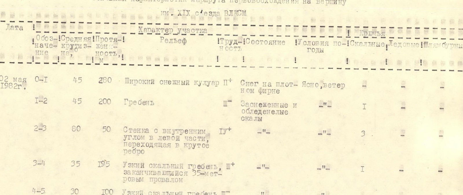
main characteristics of the route of the first ascent to the peak named after the XIX Congress of VLKSM
| Date | Designation | Average steepness | Length, m | Character of the section | Difficulty | State | Weather conditions | Pitons: Rock | Pitons: Ice | Pitons: Bolts |
|---|---|---|---|---|---|---|---|---|---|---|
| May 2, 1982 | R0–R1 | 45 | 280 | Wide snow couloir | II+ | Snow on dense firn | Clear, wind | |||
| R1–R2 | 45 | 200 | Ridge | III | Snow-covered and icy rocks | " | 1 | |||
| R2–R3 | 80 | 50 | Wall with an inner corner in the left part, turning into a steep edge | IV+ | " | " | 3 | |||
| R3–R4 | 35 | 195 | Narrow rocky ridge, ending with a 35-meter gap | III+ | " | " | 1 | |||
| R4–R5 | 30 | 100 | Narrow rocky ridge | III | " | " |