Report on the First Ascent to the Summit 3213.7 (Bolshaya Dukka-Bashi) via the "North-Eastern Ridge" Route, Category 3B (Rocky), by the "Sauk-Pai" Club Team (Syktyvkar) in May 2018
2018
I. Ascent Report
| # | 1. General Information | |
|---|---|---|
| 1.1 | Full Name, Sports Rank of the Leader | Kuznetsov Viktor Aleksandrovich, 2nd sports rank, Nevinnomyssk, Stavropol Krai. |
| 1.2 | Full Name, Sports Rank of Participants | 1. Nikolaeva Svetlana Olegovna: 1st sports rank, Voronezh; 2. Mikhailova Lyubov Sergeevna: 2nd sports rank, Samara; 3. Karavaev Maxim Georgievich: 2nd sports rank, Rossosh, Voronezh Region. |
| 1.3 | Full Name of Coach | Zhuravlev Sergei Vasilievich: Candidate Master of Sports, Category 1 Instructor-Methodologist, Syktyvkar. |
| 1.4 | Organization | NP "Northern Travels Club 'Sauk-Pai'" (Syktyvkar). |
| 2. Characteristics of the Ascent Object | ||
| 2.1 | Region | Western Caucasus, Arkhyz |
| 2.2 | Valley | Irkis |
| 2.3 | Section Number according to the 2013 Classification Table | 2.1 |
| 2.4 | Name and Height of the Summit | Bolshaya Dukka-Bashi, 3213.7 m |
| 2.5 | Geographical Coordinates of the Summit (Latitude - Longitude), GPS Coordinates | Geographical Coordinates: 43°02′8.44″; 41°06′8.2″, GPS Coordinates: 43.46939; 41.09046 |
| 3. Route Characteristics | ||
| 3.1 | Route Name | Along the North-Eastern Ridge |
| 3.2 | Proposed Category of Difficulty | 3B (Rocky) |
| 3.3 | Degree of Route Exploration | First Ascent |
| 3.4 | Terrain Type of the Route | Rocky |
| 3.5 | Height Difference of the Route (Altimeter or GPS data) | From the base camp near the mouth of the Belaya River (altitude - 1670 m) to the summit (3213.7 m) - 1369 m. Height difference of the technical part (R0 - 2500 m) to the summit (3031 m) - 1544 m. |
| 3.6 | Route Length (in meters) | 955 |
| 3.7 | Technical Elements of the Route | Category I - 620 m. Category II - 360 m. Category III - 130 m. Category IV - 70 m. Movement on a closed glacier - none. Dülfer descent - none. |
| 3.8 | Descent from the Summit | Northwest along scree and snowy slopes. |
| 3.9 | Additional Route Characteristics | 1. Convenient camp under the Oleny Pass. 2. In the off-season, crampons and ice axe are required on the approach. |
| 4. Characteristics of the Team's Actions | ||
| 4.1 | Movement Time | 16 hours |
| 4.2 | Overnight Stays | none |
| 4.3 | Route Start | 3:00, May 8, 2018 |
| 4.4 | Summit Ascent | 15:00, May 8, 2018 |
| 4.5 | Return to Base Camp | 19:00, May 8, 2018 |
| 5. Responsible for the Report | ||
| 5.1 | Full Name, e-mail | Zhuravlev Sergei Vasilievich, mr.Zhur1958@mail.ru |
II. Ascent Description
1. Characteristics of the Ascent Object
1.1. General Photo of the Summit
; curl -s -o tmpfile https://summitx.info/media/1/ZcMz6NqTGWN58nKFz4VgPQzx0YnA1s5c/img-0.jpeg↗)
Photo of the profile of summit 3213.7 (Bolshaya Dukka-Bashi) from the southwest, from the Ayuly (Belaya) river valley. May 2018.
- To the right is the north-eastern ridge - the object of the alpinist first ascent.
- The summit is not visible in the photo.
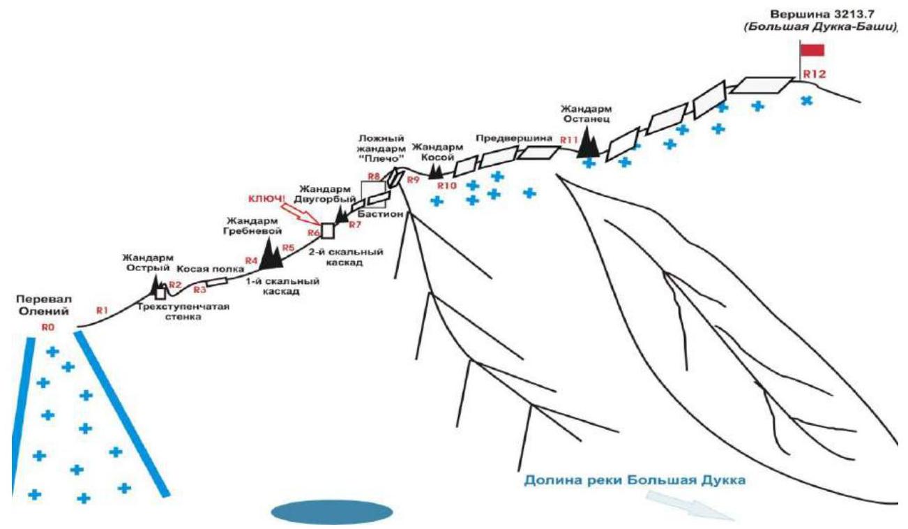
1.2. Photo Profile of the Route
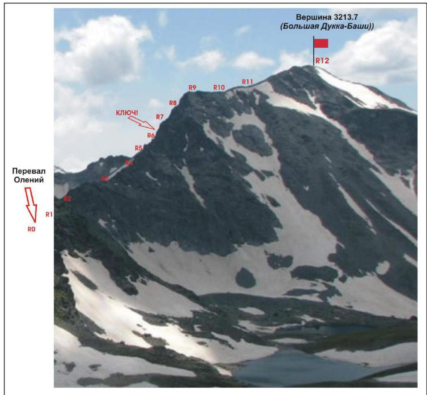
Photo profile of the north-eastern ridge of summit 3213.7 (Bolshaya Dukka-Bashi) from the northeast, from the Bolshaya Dukka river valley. The route's reference points are marked on the profile.
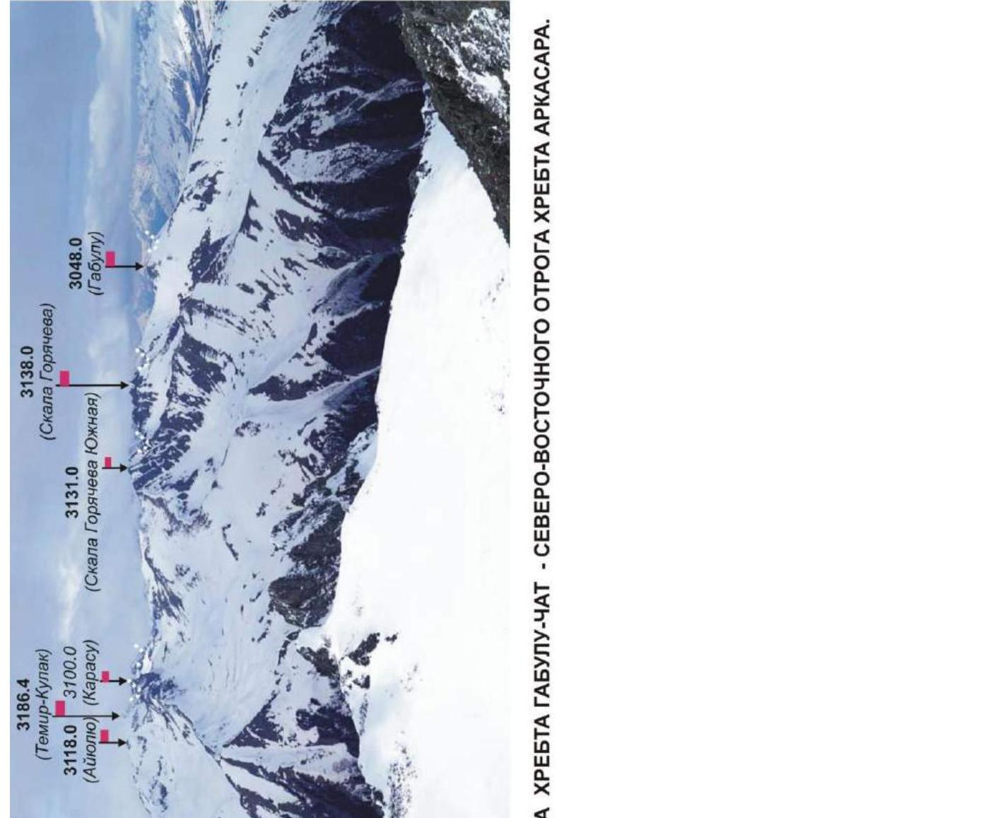
1.3. Panoramic Photo of the Area
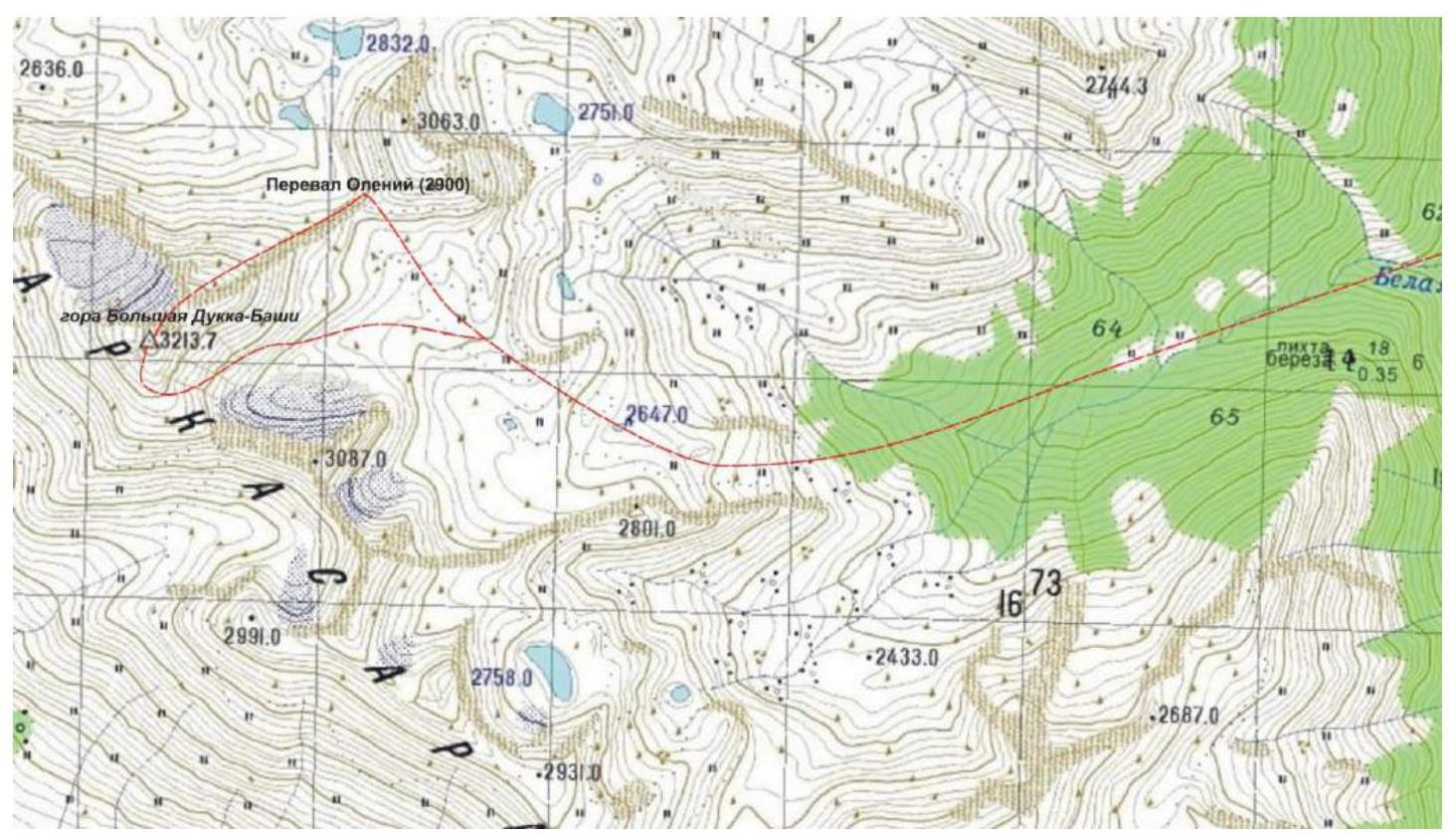
1.4. Map of the Area
Enlarged fragment of the map of the General Staff of the Russian Federation, scale 1 cm - 500 m.
Southeastern part of the Arkasara ridge. Summit 3213.7 (Bolshaya Dukka-Bashi) is located at the junction of the Arkasara ridge and its NE spur - the Gabulu-Chat ridge. The path taken by the group that made the first ascent from the Oleny Pass is marked in red.
Brief Geographical Overview of the Ascent Area. Logistics in the Ascent Area.
The Irkis valley is part of the Arkhyz mountain region (Western Caucasus), located 15 km southwest of the Arkhyz settlement, in the Zelenchuksky District of the Karachay-Cherkess Republic. The name of the valley is official and is marked on topographic maps of the Russian Federation. The valley (gorge) is formed by the ridges:
- The Main Caucasian Range with the nodal mountain Pshish - in the upper reaches of the Pshish River;
- The Sofiysky Ridge - the right bank of the Pshish River and the Irkis valley, closed by the Orlenok spur with the nodal mountain - 3031 (Orlenok);
- The Arkasara Ridge and its northeastern spur Gabulu-Chat - the left bank of the Pshish River and the Irkis valley, with the nodal mountain of the spur - Goryacheva Rock.
The base camp in the Irkis valley near the mouth of the Ayuly (Belaya) River is accessible by high-clearance vehicles from the Arkhyz settlement (3 hours), and from the Taulu glade (1 hour).
Mountain 3213.7 (Bolshaya Dukka-Bashi) has a single dome-shaped summit. It is located at the junction of the Arkasara ridge and its northeastern spur - the Gabulu-Chat ridge, between the rivers:
- Bolshaya Laba (northwest);
- Bolshaya Dukka (north, northeast);
- Ayuly (Belaya) (south, southeast).
It is a nodal summit serving as a geodetic landmark.
The name of mountain 3213.7 - Bolshaya Dukka-Bashi - is unofficial, given to identify the summit by the name of the river that originates on its northeastern slopes. At the same time, this name is well-established and used by the local population. It is a pronounced landmark for Karachay shepherds. Summit 3213.7 (Bolshaya Dukka-Bashi) in the Ayuly tract is easily identifiable as the highest mountain in the tract, located to the left along the Ayuly (Belaya) River.
The route to summit 3213.7 (Bolshaya Dukka-Bashi) "Along the North-Eastern Ridge" is a ridge route, a typical educational and sports combined route of category 3B difficulty, with a full range of natural obstacles corresponding to routes of this level.
The north-eastern ridge is easily identifiable and straightforward to locate, as it follows the axial watershed line of the Gabulu-Chat ridge, with a pronounced decrease to the east (Oleny Pass). The route is logical and unambiguous from the ascent to the ridge to the summit, and does not cause orientation problems.
2. Route Characteristics
2.1. Technical Photograph
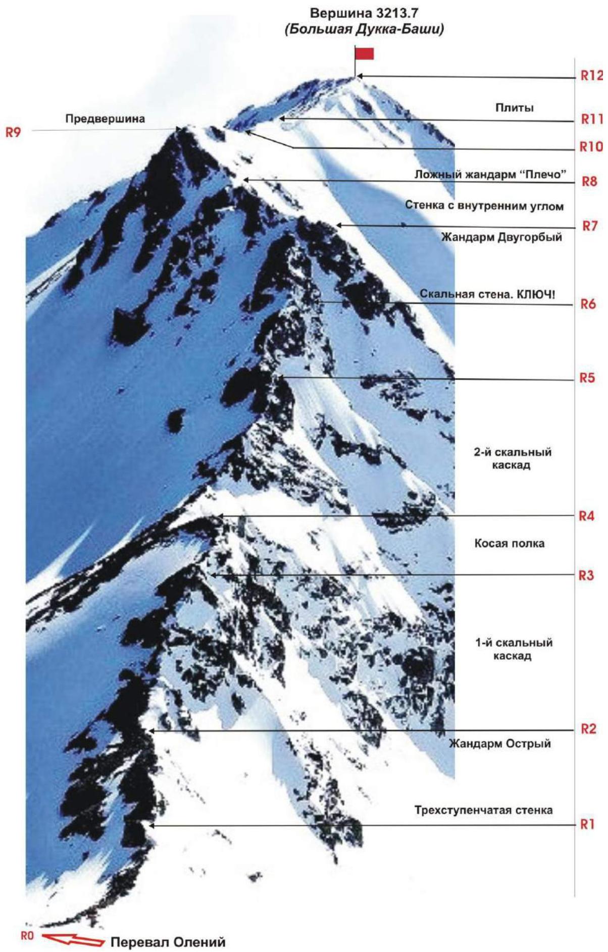
Photo of the route from summit 3063.0 (Belo-rechenskaya). Time of shooting 6:00, May 3, 2018.
2.2. Technical Characteristics of Route Sections
Diagram in UIAA symbols, table of technical sections.
| Section # | Terrain Type | Category of Difficulty | Length, m | Type and Number of Hooks |
|---|---|---|---|---|
| R0 | Location of rope team organization, start of the technical part of the route. Altitude - 2500 m above sea level. | |||
| R0–R1 | Snow, scree | 1 | 200 | 0 |
| R1–R2 | Rocky ridge | 3 Convenient station | 35 | 5 stops |
| R2–R3 | Jagged rocky ridge | 2–3 Stations are convenient | 150 | 4 stops |
| R3–R4 | Stepped ridge | 3 Convenient station | 50 | 6 stops |
| R4–R5 | Traverse and ascent to the Dvugorby pinnacle | 3–4 Convenient station | 50 | 7 stops |
| R5–R6 | Steep stepped ridge | 4–, 4+ Convenient station | 50 | 6 stops 2 crampons ("channel") |
| R6–R7 | Rocky ridge | 2 Convenient station | 50 | 0 |
| R7–R8 | Traverse: bypassing the bastion | 3 Convenient station | 50 | 4 stops |
| R8–R9 | Passage of a series of slabs. | 3 Convenient station | 60 | 4 stops |
| R9–R10 | Destroyed rocks and internal corner. | 2 Convenient station | 50 | 0 |
| R10–R11 | Inclined rocky slabs. Exit to the sub-summit | 2 | 150 | 0 |
| R11–R12 | Inclined rocky slabs. Exit to the summit | 3 Convenient station | 60 | 6 stops |
| R12 | Summit 3213.7 (Bolshaya Dukka-Bashi). |
3. Characteristics of the Team's Actions
3.1. Brief Description of the Route Passage.
| Section # | Description | Photo # |
|---|---|---|
| APPROACH | From the base camp on the left bank of the Pshish River near the mouth of the Ayuly (Belaya) River, ascend along the trail on the left bank of the Ayuly (Belaya) River, past the Medovy waterfall. Ascend to the snowy cirque under the Oleny Pass. Then ascend to the Oleny Pass along the snowy slope. | |
| R0 | Oleny Pass. Location of rope team organization. Convenient place for a short rest, snack, and equipment preparation. | |
| R0–R1 | Approach along the snowy ridge under the Ostry pinnacle to the start of the technical part of the route. Slope steepness - 15°. Simultaneous movement with a shortened rope. Length - 200 m. Difficulty level - 1. | |
| R1–R2 | Ascent along the rocky ridge to the first rocky shoulder, bypassing the "Ostry" pinnacle. Dense steep rocks. Wall of three steps. Movement with alternate belay and use of fixed ropes. Convenient stations below the ridge and above for belay and rope fixing - large chip. Step steepness - 80°, 90°, 75°. Step height - 35, 5, 4 m. Length - 50 m. Difficulty level - 4. | |
| R2–R3 | Passage of the serrated jagged ridge (section "Pila") to the start of the oblique ledge. Movement with alternate belay using projections, loops thrown over projections. Section steepness - 45-50°. Section length - 150 m. Difficulty level - 2 with elements of 3. | |
| R3–R4 | Passage along the stepped ridge to the Dvugorby pinnacle. Movement with alternate belay. Convenient ledges and large projections for station organization at the start and end of the section. Finding relief for protection is not problematic. Three steps with steepness: 75°, 30°, 65° and height: 10, 30, 10 m. Total section length - 60 m. | |
| R4–R5 | Traverse of the Dvugorby pinnacle and ascent to it (to the right along the route). Movement with alternate belay. Smooth monolithic rocks. Convenient ledges and large projections for station organization at the start and end of the section. Finding relief for protection is not problematic. Section steepness - 60°. Length - 50 m. Difficulty level - 3+, 4-. | |
| R5–R6 KEY! | Passage of the key section of the route - a cascade of ridge steps and a wall with a counterfort. Smooth monolithic rocks. Finding places for hooks and protection is challenging; the rocky relief is poor in projections and ledges. Convenient ledges and large projections for station organization at the start and end of the section. Key wall - a rocky section of increased difficulty - 15 m with a steepness of 80°. Total section length - 60 m. | |
| R6–R7 | Passage along the stepped rocky ridge to the rocky bastion. Movement with alternate belay. Convenient ledges and large projections for station organization at the start and end of the section. Finding relief for protection is not problematic. Section steepness - 15-25°. Length - 50 m. Difficulty level - 2. | |
| R7–R8 | Traverse of the rocky bastion. Traverse along inclined slabs, then along a series of small inclined ledges. Alternate belay. Rope fixing. Relief allows the use of medium-sized friends. Convenient station below on a rocky chip and above on a large stone block. Section steepness - 40°. Length - 50 m. Difficulty level 3+. Section is psychologically challenging for the last participant. | |
| R8–R9 | Passage of the "First Slabs (with an internal corner)" section. Rocky inclined slabs, with an internal corner at the top. Subjective increased rockfall danger: slabs are covered with rock debris! Simultaneous movement on a shortened rope, using relief bends for belay. Slab length - 50 m. Steepness - from 20° to 60°. Internal corner - 7 m with a steepness of 80°. | |
| R9–R10 | Passage from the internal corner along the destroyed rocky ridge to the "Kosoy" pinnacle-remnant. Flattening slab-like rocks, snowy-icy bridge. Bypassing the pinnacle-remnant along destroyed rocks (to the right along the route). Movement on a shortened rope. Simultaneous, using relief bends for belay. Section steepness - 15°. Length - 150 m. Difficulty level - 2, 1+. | |
| R10–R11 | Ascent to the sub-summit (rocky-scree shoulder) along inclined slabs. Simultaneous movement on a shortened rope, using relief bends for belay. Section steepness - 25-30°. Length - 150 m. Difficulty level - 2, 1+. | |
| R11–R12 | Ascent to the summit dome along destroyed slab-like rocks and scree. Simultaneous movement on a shortened rope. Use of self-belay techniques. Section steepness - 15-20°. Length - 300 m. Difficulty level - 1. | |
| R12 | Summit - snowy-scree dome. Cairn in the northern part, near the reference point of the Russian geodetic network. | |
| DESCENT | Descent from the summit is technically simple. Along snowy fields, first southwest towards the Ayuly (Belaya) river valley, then along the snowy slope into the valley of the (Ayuly) Belaya River. |
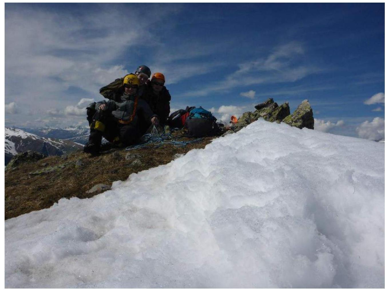
3.2. Photo of the Team at the Summit by the Control Cairn.
3.3. Safety Assessment of the Route.
The route to summit 3213.7 (Bolshaya Dukka-Bashi) is a typical ridge route of category 3B difficulty, allowing to test not only the technical knowledge, skills, and abilities of climbers of the 3rd sports rank and above but also their tactical preparedness.
Accessible approaches and ease of orientation when searching for the route (the route starts from the popular Oleny Pass) are one of the safety qualities.
Communication on the route was carried out using VHF radios, but with interruptions - there is no direct visibility of the route from the Irkis valley, from the base camp. To communicate, it is necessary to descend downstream of the Pshish River. Mobile phone communication with the Arkhyz settlement and emergency services is possible throughout the technical section from the Oleny Pass to the summit.
The route is a ridge route, which increases the level of safety when used for educational and sports purposes. Throughout the route, there are convenient ledges and platforms for organizing stations. The relief allows the use of various protection elements for organizing intermediate belay points and self-belay. In the off-season, it is a characteristic combined route, requiring participants to have the skills to move on snowy terrain and organize belay points using an ice axe. The route meets the safety requirements of alpine educational and sports routes.
Route analogues: Rongetti (traverse) (North Ossetia, Tsey) - 3B category of difficulty, 3200 (Taulan, Dimitrov-100) along the NW rib - 3B category of difficulty (Arkhyz, Orlenok gully).
Photo Illustrations
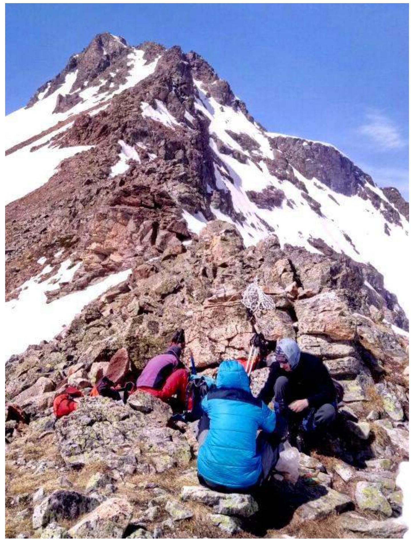
Photo #1: R0 - Oleny Pass, location of rope team organization. Photo by participant M. Karavaev, May 2018.

Photo #2: Section R1–R2. Start of the technical part of the route, approach under the "Ostry" pinnacle. V. Kuznetsov is the first to pass the section. Photo by participant M. Karavaev, May 2018.
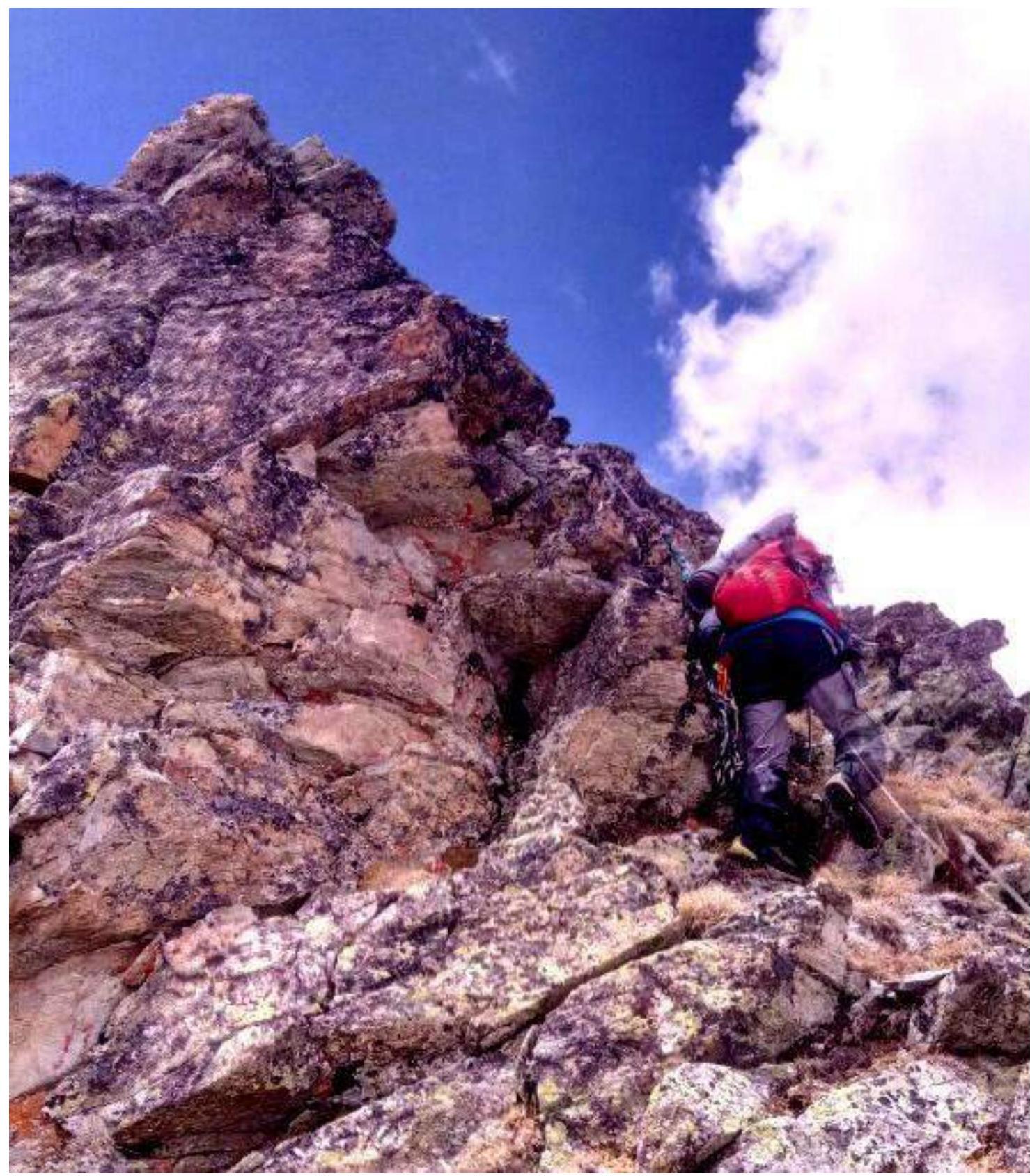
Photo #3: Section R3–R4. Ascent to the "Ostry" pinnacle. Photo by participant M. Karavaev, May 2018.
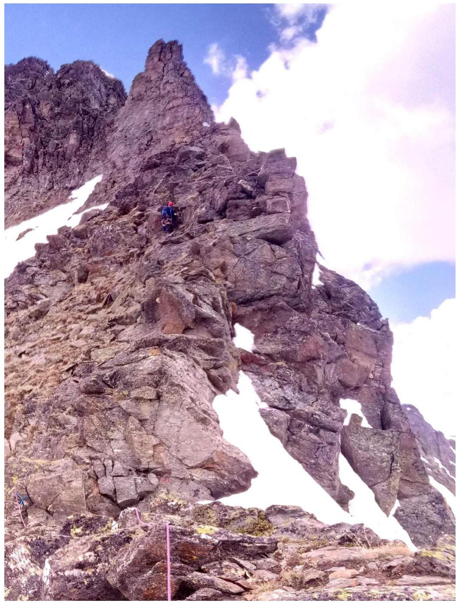
Photo #4: Section R4–R5. Passage of the ridge and walls of the "Grebnevoy" pinnacle. V. Kuznetsov is the first to pass the section. Photo by participant M. Karavaev, May 2018.
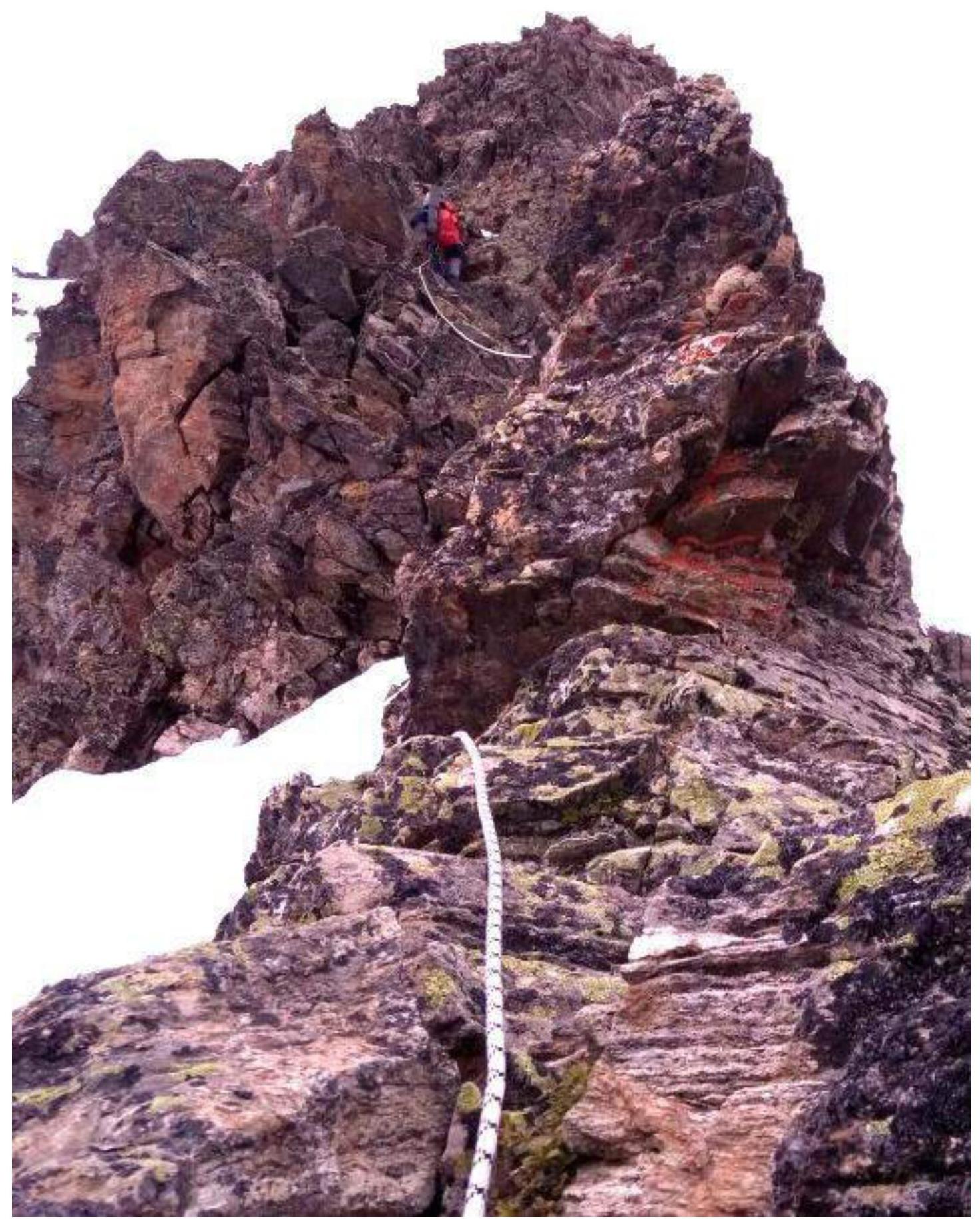
Photo #5: Section R5–R6. Passage along fixed ropes of the key section by L. Mikhailova. Photo by participant M. Karavaev, May 2018.
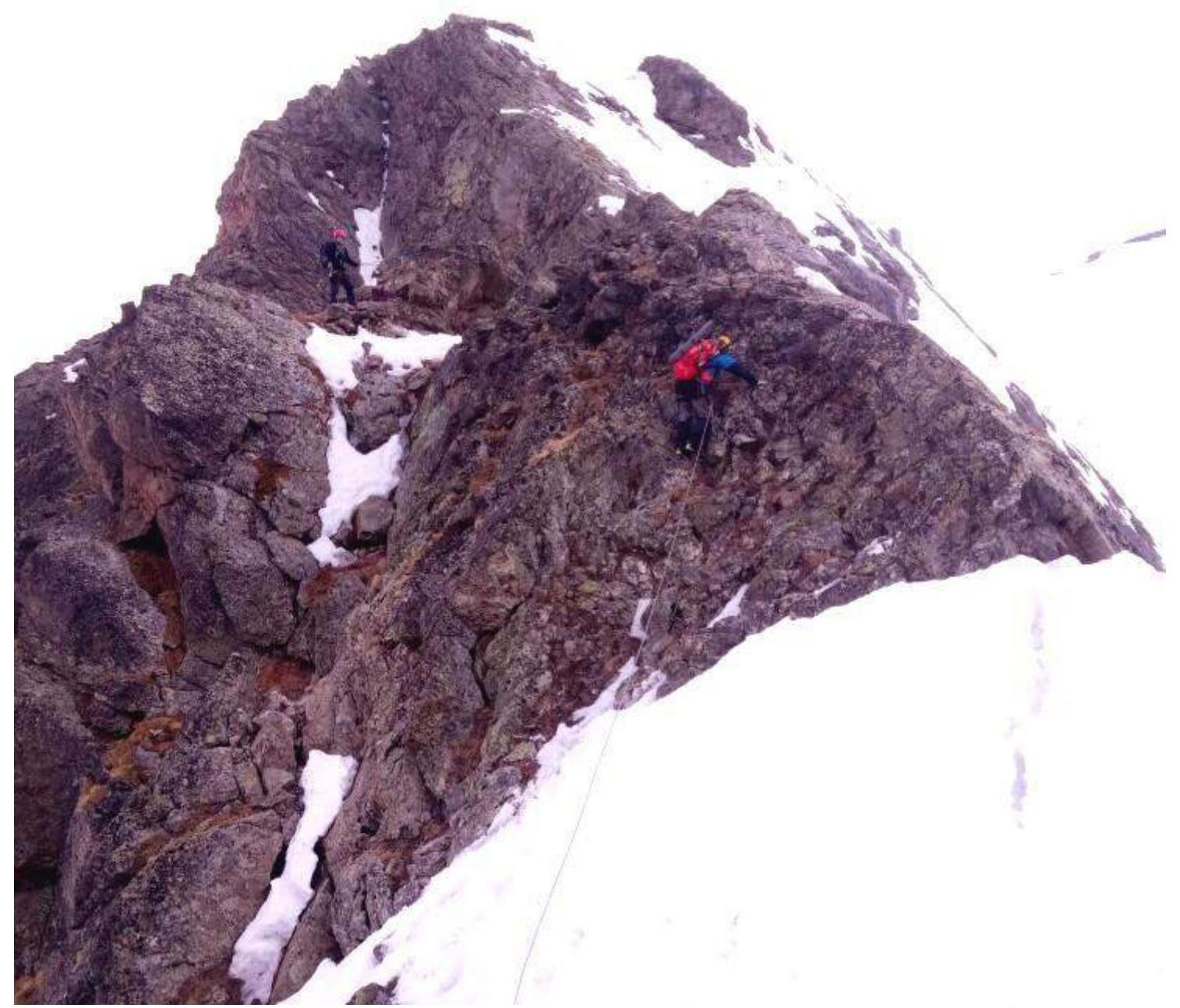
Photo #6: Section R6–R7. Ascent to the "Dvugorby" pinnacle. In the photo, V. Kuznetsov and L. Mikhailova are passing the section. Photo by participant M. Karavaev, May 2018.
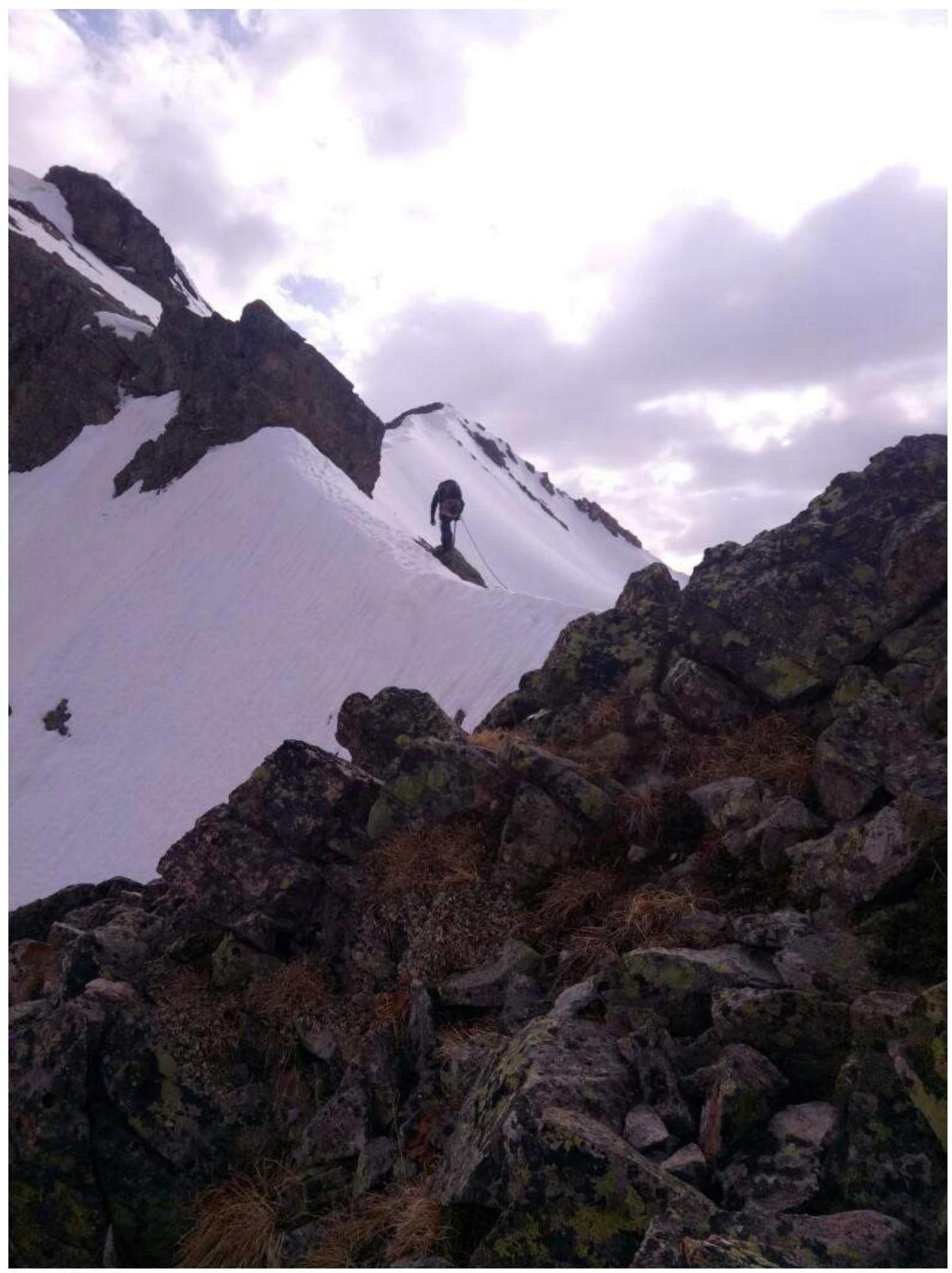
Photo #7: Section R7–R8. Bypassing the "Ostants" pinnacle. Photo by participant M. Karavaev, May 2018.
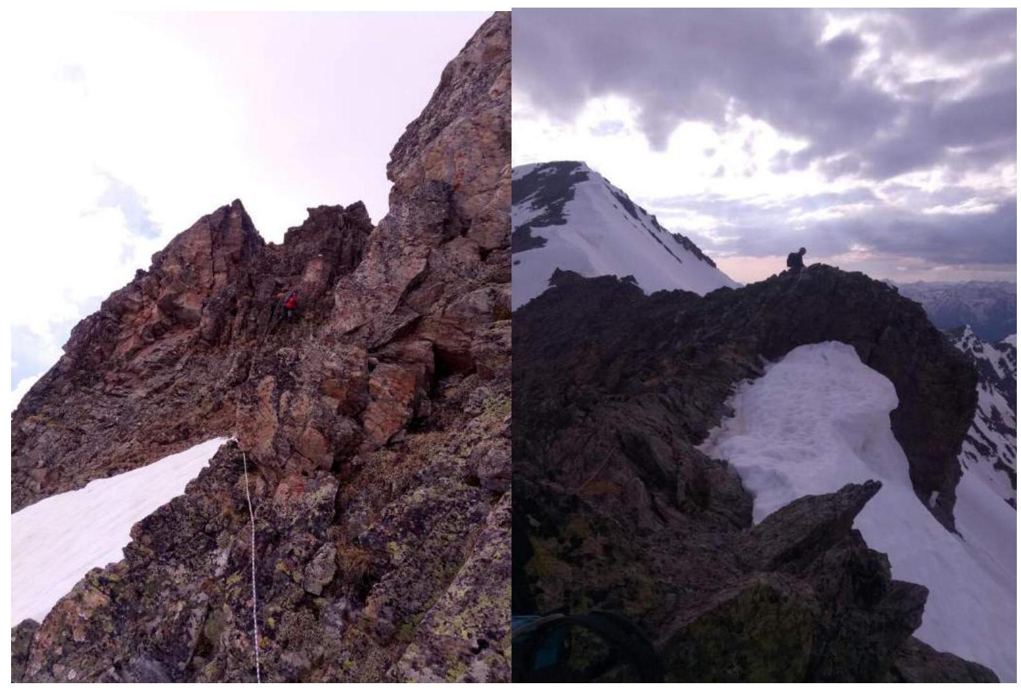
Photo #8 and 8a: Section R8–R9. Rocky ridge before exiting to the sub-summit. Ascent from the sub-summit to the summit. In the background - the summit of Bolshaya Dukka-Bashi.
Conclusion
Excerpt from the Coaching Council Decision of May 9, 2018
on the results of the analysis of the first ascent of the alpine route to summit 3214 (Bolshaya Dukka-Bashi). Route: "Along the North-Eastern Ridge" 3B category of difficulty, rocky (tentatively), carried out as part of the alpine competitions: "Second stage of the NP 'Northern Travels Club 'Sauk-Pai' cup - 'Irkis-2018'" (class "First Ascents").
An analysis was conducted of the first ascent of the alpine route to summit 3214 (Bolshaya Dukka-Bashi). Route: "Along the North-Eastern Ridge", 3B category of difficulty, rocky (tentatively). The analysis and subsequent coaching council were attended by:
- Zhuravlev S. V. (Syktyvkar, Candidate Master of Sports, Category 1 Instructor-Methodologist) - senior coach-releaser, chief judge of the NP 'Northern Travels Club 'Sauk-Pai' cup competitions;
- Babkin V. V. (Yekaterinburg, Candidate Master of Sports, Category 2 Instructor-Methodologist) - safety officer of the NP 'Sauk-Pai' alpine competitions, deputy chief judge for safety;
- Maltsev S. L. (Ukhta, 1st sports rank, Category 2 Instructor-Methodologist) - senior judge-expert in the sports discipline of the "Class of First Ascents" competition;
- Toropov V. A. (Syktyvkar, 1st sports rank, Category 3 alpine instructor-methodologist).
The route sheet stated an ascent to summit 3214 (Bolshaya Dukka-Bashi) of category 4A difficulty (combined).
The route was completed within the stated timeframe, without violations of safety regulations. As a result of the analysis, it was determined that sections of category 4 difficulty are present on the route, but are not decisive for the category of the route according to the methodology for classifying alpine routes. (Note: according to the revised methodology for determining route complexity, the category of difficulty is determined by the total length (at least 200 m) of technical sections of the corresponding category). On this route, the total length of sections of category 4 difficulty is not more than 70 m. Additionally, the route is combined only until May 20; in the summer period, it is rocky.
The decision of the group leader to bypass the traverse of the rocky bastion in the central part of the route, which could have increased the category of difficulty, was recognized as correct by the coaching council. Passing the bastion, which can be bypassed by traverse, would have been an artificial complication of the route, which does not correspond to sports ethics and safety requirements.
According to the photographs of the technical sections, the diagram compiled by the participants in UIAA symbols with a table of route obstacles, the route corresponds to the technical level of category 3B difficulty (rocky).
Decisions of the coaching council:
- To confirm the leadership to the ascent leader of category 3B difficulty, and to the participants - participation in the ascent of category 3B difficulty;
- For the sports group to prepare and submit a report on the first ascent of the alpine route to the Classification Commission of the FAR;
- To recommend the route to summit 3214 (Bolshaya Dukka-Bashi) for inclusion in the CMGV as a rocky route - category 3B difficulty.
The decision was signed by members of the coaching council. The presence of signatures by S. V. Zhuravlev, V. V. Babkin, S. L. Maltsev is confirmed by the acting director of NP 'Northern Travels Club 'Sauk-Pai'" - S. V. Zhuravlev.
Review of an Independent Expert
I have reviewed the "Report on the first ascent of the alpine route to summit 3214 (Bolshaya Dukka-Bashi) as part of the alpine competitions: 'Second stage of the NP 'Northern Travels Club 'Sauk-Pai' cup - 'Irkis-2018' (class 'First Ascents') in May 2018".
The report is thorough, with an accessible and detailed description of the route, readable and good-quality photos and diagrams. The quality of the report allows alpine groups to obtain comprehensive information and repeat the route in the previously little-explored region of the Western Caucasus.
There is a feeling that the proposed tentative category of difficulty ("3B") is slightly overestimated. As follows from the report, most sections were passed simultaneously. The key section - a 15-meter wall on R5–R6, with a steepness of 80° - is essentially the only extended fragment with serious climbing.
Plyukhin Yuri Viktorovich, Master of Sports of the USSR, Category 2 Instructor (Certificate #167). Experience working in the regions of the Western Caucasus (Dombay resort, "Alibek", Dombay region KSP) - 1960-1995, in positions:
- instructor;
- head of the rescue team;
- KSP instructor.