Peaks:
- 3090 m (Dorbun-Kaya Northern)
- 3117 m (Dorbun-Kaya Main)
Route: traverse of the Dorbun-Kaya mountain massif from north to south
Difficulty category — 3A
Combined difficulty category
Leader: A. Lyapun
Western Caucasus, Arkhyz, Irkis valley, Arkassara ridge, Amanaus river mountain valley
Section in KMGV — 2.1.
Report
On the first ascent of the climbing route to the peaks: 3090 m (Dorbun-Kaya Northern) — 3117 m (Dorbun-Kaya Main) within the framework of climbing competitions: "Third stage of the NP «Sauk-Pay» club cup — «Irkis-2015»" (class «First ascents») in May 2015.
Route: traverse of the Dorbun-Kaya mountain massif from north to south
Difficulty category — (approximately) 3A combined
Region: Karachay-Cherkess Republic Mountain country: Western Caucasus Gorge: Irkis valley Ridge: Arkassara ridge, Amanaus river mountain valley Peaks: 3090 m (Dorbun-Kaya Northern) — 3117 m (Dorbun-Kaya Main) Route: traverse of the Dorbun-Kaya mountain massif from north to south Difficulty level: 3A category. (combined) (approximately)
Prepared by: A. Lyapun, S. Zhuravlev May, 2015
Amanaus River Mountain Valley
The Amanaus river valley is located in the southeastern part of the Arkassara ridge.
The Amanaus river valley is a pronounced mountain horseshoe formed by the southeastern and eastern-southeastern spurs of the Amanaus mountain (in climbing literature — Academician Kolesnik peak), part of the Main Caucasian Ridge — Psyrts ridge — and the spurs of the Pshish mountain massif.
The peaks of the spurs and passes do not have official names, but each has traditional names established in guides and guidebooks:
- 2989 (Caucasian Mountain Society peak)
- Tolyatti pass
- 3090 (Dorbun-Kaya Northern)
- 3117 (Dorbun-Kaya Main)
- Duritskogo pass
- 3213 (Azimba Eastern)
- Amanaus North pass
- 3534 (Amanaus, Academician Kolesnik peak)
- Amanaus pass
- 3457 (Psyrts)
- in climbing literature — 60th anniversary of VLKSM (3400)
- 2898, 3044 (GKKh peaks — Psyrts ridge)
- 3638 (Pshish South)
- Pshish (3790)
Along the Amanaus river, there is a pronounced mountain trail. Branches from the trail lead to passes popular with hiking tourists of various difficulty categories.
Characteristic features of the peaks in the Amanaus river valley:
- Long approach with a sharp gain in altitude
- Rock towers made of dense rocks with small, technically complex sections
- High level of glaciation — Amanaus glacier and others
During the off-season, there is a possibility of increased avalanche danger. On rocky ridges — an abundance of snow overhanging cornices.
Due to the large gain in altitude (over 1500 m) from the Irkis valley, ascents to the peaks of the Amanaus river mountain valley are conveniently done with an approach. There is a convenient campsite for a base camp at the mouth of the Amanaus river — flat areas for tents, provision of drinking water year-round.
Within the framework of climbing competitions: "3rd stage of the NP «Sauk-Pay-2015» cup" (Class «First ascents») two ascents were made to the peaks of the Amanaus valley with the goal of classifying previously climbed, but not included in the classifier, climbing routes:
- Traverse: 3090 (Dorbun-Kaya Northern) — 3117 (Dorbun-Kaya Main) — 3A category.
- Traverse: 3117 (Dorbun-Kaya Main) — 3090 (Dorbun-Kaya Northern) — 3A category. (R. Gordy's route)
The Amanaus river valley has many promising climbing routes that require development and can enrich the climbing map of the Western Caucasus. A striking example is the Pshish mountain massif — the highest mountain of Arkhyz (3790 m), which still has no classified route to its peaks.
Note: reports on the completed route ascents are attached.
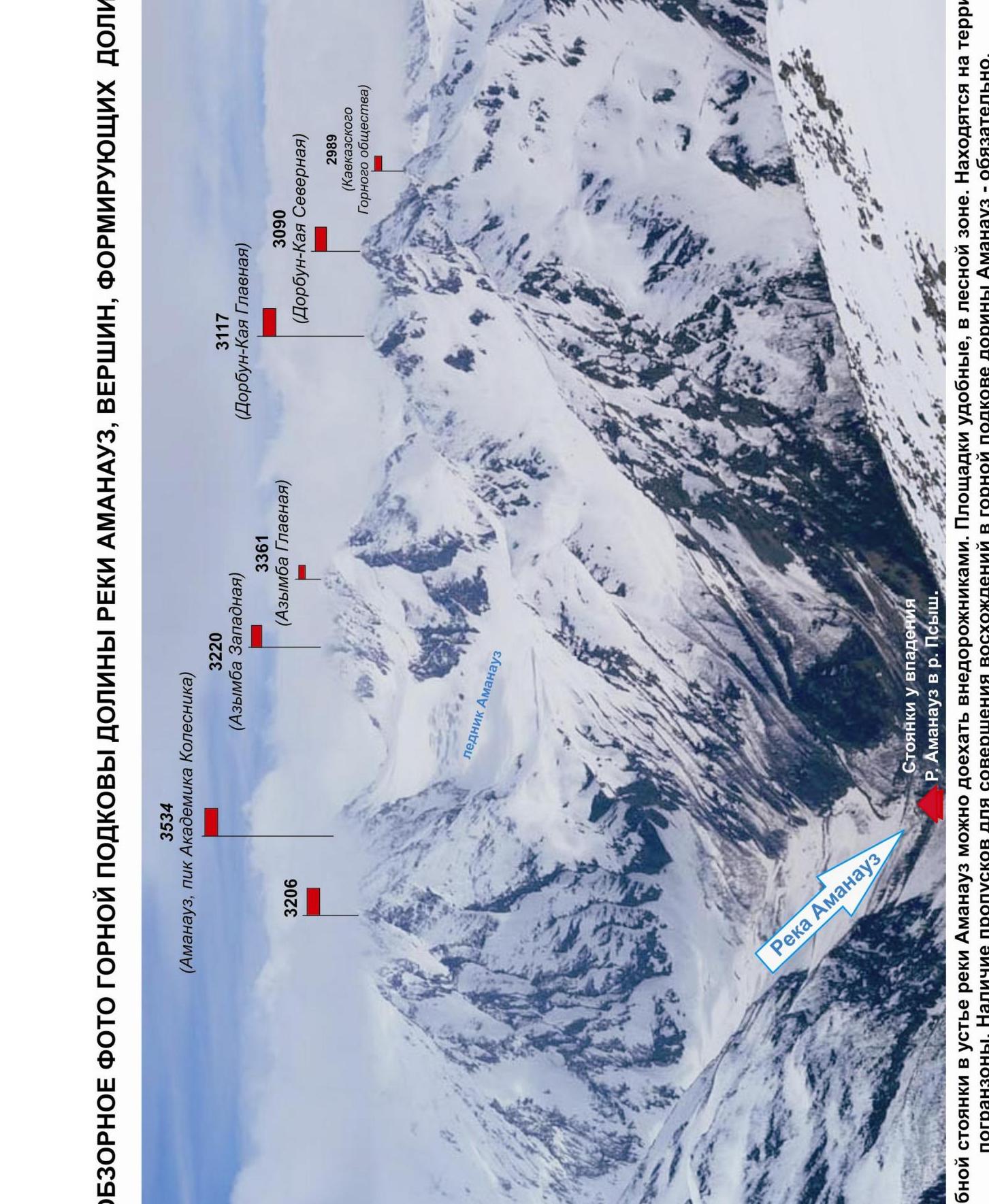
Overview photo of the mountain horseshoe of the Amanaus river valley, peaks forming the valley.
FRAGMENT OF MAP M: 1 cm — 500 m. APPROACH SCHEME.
Passport
- Section number according to KMGV — 2010 — 2.1.
Western Caucasus, mountain region — Arkhyz, Irkis valley. Arkassara ridge. Amanaus river mountain valley.
- Names of peaks: Peaks: 3090 (Dorbun-Kaya Northern) — 3117 (Dorbun-Kaya Main)
- Height: 3090, 3117
- Route: traverse of the Dorbun-Kaya mountain massif from north to south
- Difficulty category: 3A category.
- Route character — combined.
- Altitude difference of the route:
From the base camp (mouth of the Amanaus river) — 1500 m
- Route length:
Total length (from the base camp at the mouth of the Amanaus river) — 5000 m. Technical part — 770 m
- Length of sections of the highest difficulty category:
n/k — one section — 150 m; 2 category — five sections — 210 m; 3 category — two sections — 170 m; 4 category — 0 sections — 0 m; 5 category — 0 sections — 0 m; 6 category — 0 sections — 0 m.
- Average steepness: total route — 65°
technical part — 75°
- Number of pitons used:
Total used on the route:
- rock pitons — 15
- chocks — 17
- stationary bolt pitons — 0
- IT — 0
- removable bolt pitons — 0
Left «piton» on the route:
- total — 2
- including bolt pitons — 0
- Route start — 4:00, August 7, 2015.
Reached peak 3090 m (Dorbun-Kaya Northern) — 13:00, May 7, 2015. Reached peak 3117 m (Dorbun-Kaya Main) — 15:00, May 7, 2015. Return — 19:00, May 7, 2015.
- Team's working hours: — 15 hours.
- Leader: Alexander Lyapun (Sevastopol, Master of Sports of the USSR, instructor-methodologist 2nd category.).
Participants:
- Kuznetsov Alexey (Moscow, 3rd sports category)
- Maltsev Fedor (Moscow, 3rd sports category)
- Paramonchev Alexander (Samara, 3rd sports category)
- Coach: Zhuravlev Sergey Vasilyevich (Candidate for Master of Sports, instructor-methodologist 1st category.).
Analogous routes:
- traverse of Pirogov — Khirkhatten — 3A (Midagrbin)
- traverse of Ronkketti (V-Gl) 3A (Tsey)
- traverse of Tsiti (3B) from the Midagrbin glacier 3A (Medagrbin)
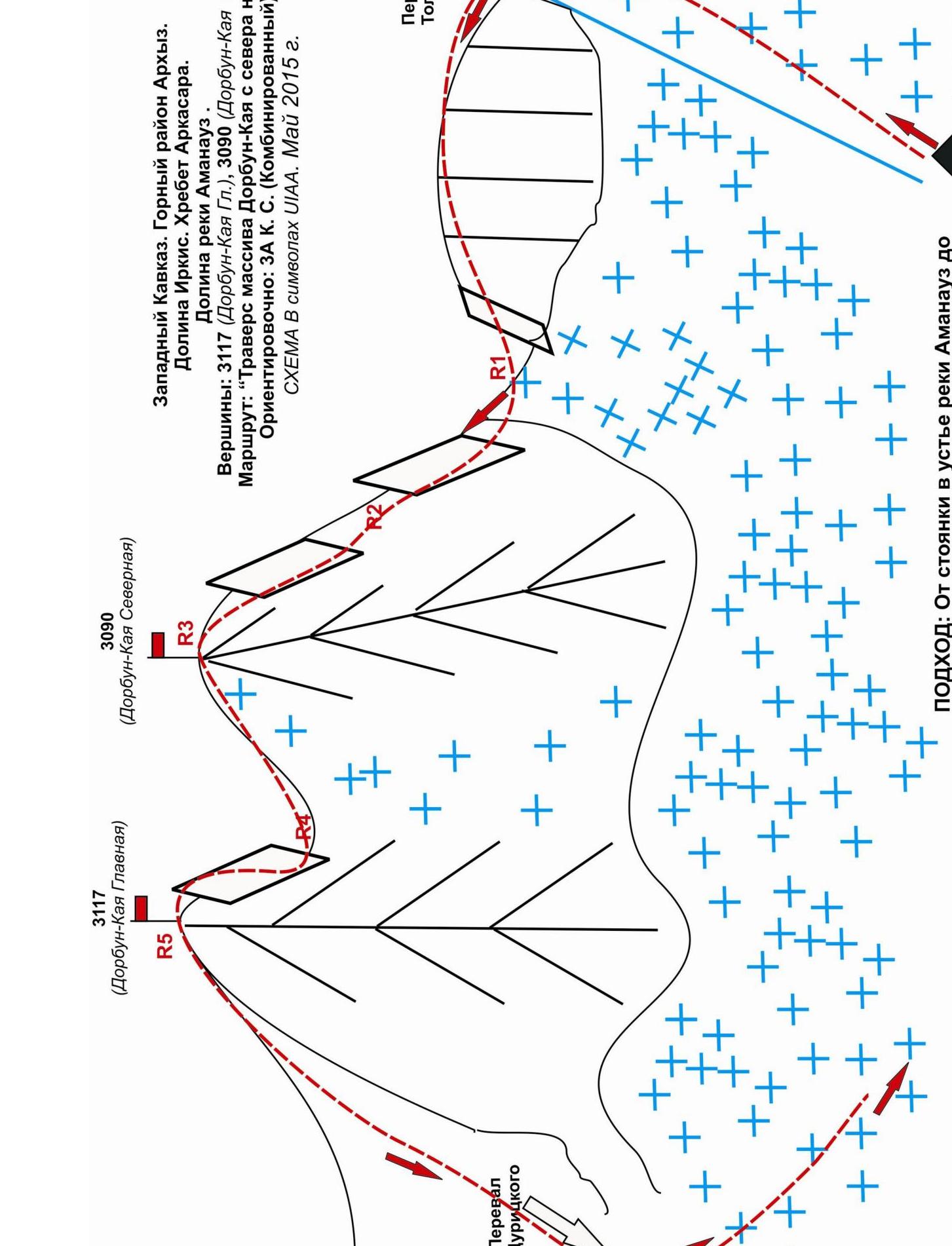
Western Caucasus. Mountain region Arkhyz. Irkis valley. Arkassara ridge. Amanaus river valley.
Peaks: 3117 m (Dorbun-Kaya Main), 3090 m (Dorbun-Kaya Northern)
Route: "Traverse of the Dorbun-Kaya massif from north to south".
Approximately: 3A category. (Combined). Technical photo of the route from the Belaya (Ayyulyu) river valley. May 2015.

Description of the mountain
The mountain (Dorbun-Kaya) is located on the northeastern spur of the Arkassara ridge, separating the valleys of the Amanaus and Belaya (Ayyulyu) rivers. The mountain is clearly visible and recognizable from both the Amanaus river valley and the Belaya (Ayyulyu) river valley.
The mountain has two rock towers — peaks. On the map — a kilometer grid of the General Staff of the Russian Federation — there is a height mark only at Dorbun-Kaya Main — 3117 m. The name is not marked on the map, but is traditional and established, both among local residents and among tourists and climbers.
To date, one route has been entered into the classifier for the peak 3117 (Dorbun-Kaya Main): along the southern ridge from the Duritskogo pass, 2B category. At the same time, it is known that other routes have been climbed by climbers from the Stavropol region:
- To 3090 (Dorbun-Kaya Northern) along the northeastern ridge — 2A (Zaporozhchenko)
- Traverse of the Dorbun-Kaya mountain massif from south to northeast — 3A (Gordy)
The reason why the climbed routes were not included in the classifier is not clear: it is possible that the materials on their passage were in the archive of Gordy, who died during the ascent to the Pshish peak, and were lost after his death.
Description of the route
Route: "Traverse of the Dorbun-Kaya mountain massif from north to south" — a characteristic training-competitive combined route of 3A category, with a full range of natural obstacles corresponding to routes of this level.
Equipment
To complete the ascent, a sports detachment of 4 people requires the following special equipment on the route:
-
Personal — standard, crampons, ice axe
-
Public:
- main rope 10 mm — 2×50 m
- rock hammer — 2 pcs.
- rock pitons — 10 pcs.
- ice axe — 1 pc.
- chock elements — 12 pcs.
- friends — 6 pcs.
- ice screws — 0 pcs.
- extensions — 16 pcs.
- loops — 10 pcs.
Approach
From the base camp located near the confluence of the Aksaut river into the Pshish river, ascend along the left (orographic) bank of the Aksaut river, first along a pronounced, then temporarily disappearing trail. Follow the trail to the branch leading to the Tolyatti pass. A characteristic landmark to the right along the way — a large triangular giant. The giant remains to the left along the way.
The Tolyatti pass, connecting the Amanaus river valley with the Belaya (Ayyulyu) river valley, is easily identified by the clearly visible saddle in the northeastern spur. The approach from the base camp near the mouth of the Amanaus river to the saddle of the Tolyatti pass takes 4 hours.
The technical part of the route begins at the Tolyatti pass. At the Tolyatti pass, it is necessary to organize rope teams.
Technical part
Having reached the saddle of the pass and organized rope teams, ascend to the rocky ridge. Traverse the rocky ridge for 150–200 m (simultaneous movement, insurance through ledges) and organize a sport descent to the saddle under the rock tower 3090 (Dorbun-Kaya Northern), sometimes referred to as the false Tolyatti pass.
Then ascend the rocks to the rocky shoulder. Climbing is more complex than on the ridge and requires organization of alternate insurance. For intermediate points, it is convenient to use:
- rock ledges — for loops,
- cracks — for large chocks and friends.
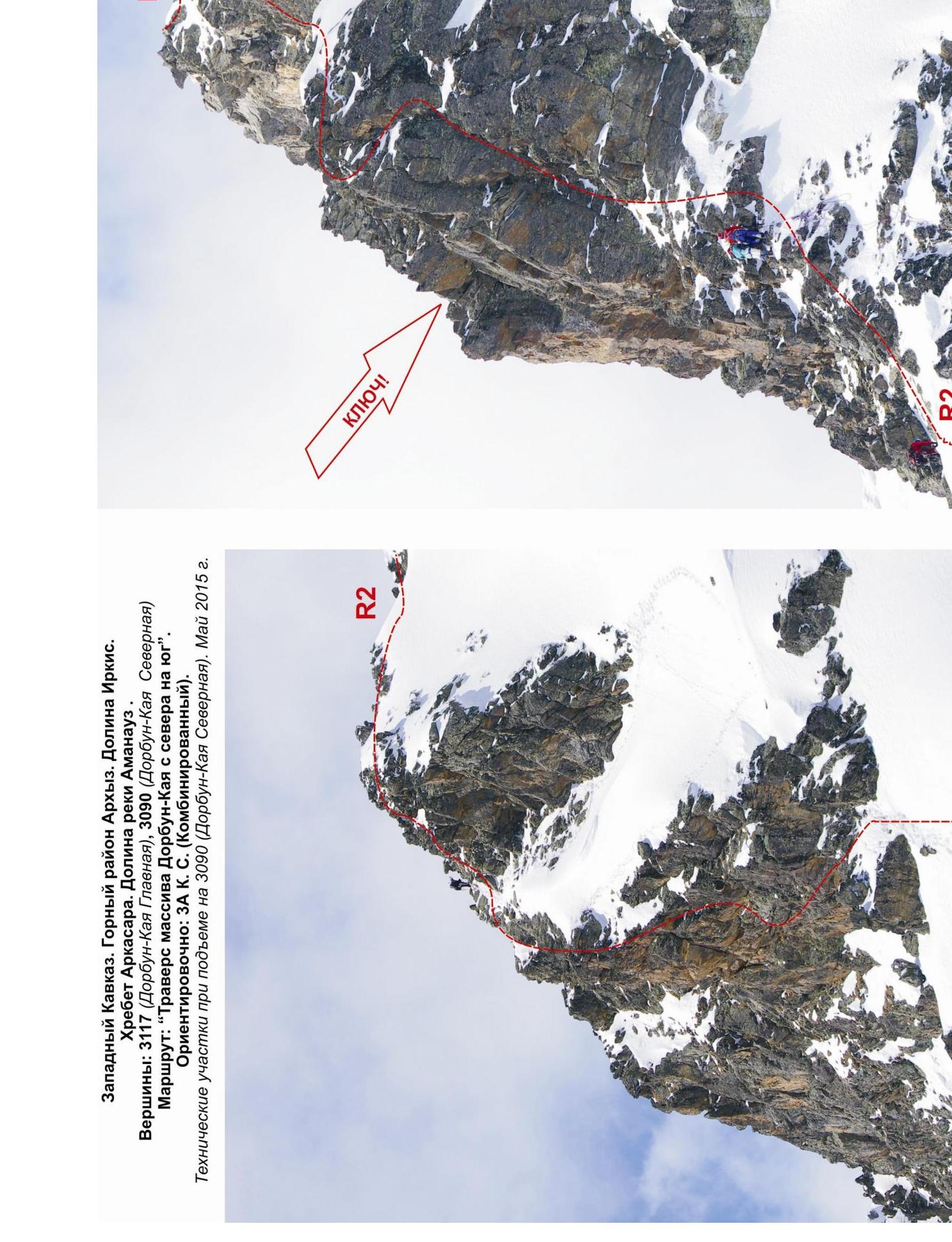
On the shoulder, after a short transition along the destroyed rocky ridge, approach the key of the route.
KEY: technically complex wall — a monolith with weakly expressed parallel internal corners going upwards. The group that classified the route ascended along the right (along the way) internal corner.
Climbing is complicated, the wall is steep. However, the first climber's movement is stable, as there is enough micro-relief for organizing intermediate insurance points
- there are cracks in the rock suitable for pitons;
- there are cracks for medium-sized chock elements (4–6).
After passing the wall — exit to the destroyed summit ridge and further to the summit.
Peak 3090 (Dorbun-Kaya Northern) — small, clearly visible. A cairn is located in the center on a large flat stone block.
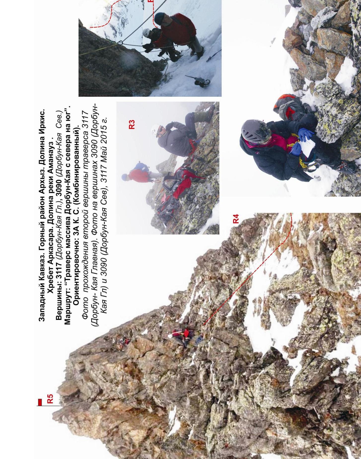
After ascending to the northern peak, descend sportingly (in bad weather, by rappelling with holding) to the saddle between the two Dorbun-Kaya peaks. Then ascend along a relatively complex rocky wall to the peak 3117 (Dorbun-Kaya Main).
The wall is steep, but with an abundance of ledges and ledges, it is freely passable in any part. There are plenty of places for organizing intermediate insurance points. The rocks are dense. Rockfall danger is subjective.
Peak 3117 (Dorbun-Kaya Main) — a clearly visible peak. A cairn is located in the center. Descent from the peak is done along the rocky wall by rappelling with pulling.
In bad weather, it should be remembered:
- At the junction of the southern and northern ridges, it is necessary to turn left along the way, otherwise the descent will be not to the Duritskogo pass, but to the Dorbun pass into the Belaya (Ayyulyu) river valley with a more complex descent into the Irkis valley.
Descent along the southern ridge after rappelling with pulling on 50 m and 30 m leads to a series of slabs and ledges, along which it is easy to descend to the Duritskogo pass.
Descent from the pass along the tourist trail does not cause difficulties. In the off-season, it is necessary to monitor the condition of the snow cover on the slopes of the northeastern spur, along which the trail goes, as avalanches and cornice collapses are possible.
Due to the accessibility of the route in terms of orientation, it can be recommended:
- For training-competitive detachments (SP-1, 2)
- For independent sports groups of разрядников, conducting leadership or training ascents
Time spent on the route for a training-competitive detachment of разрядников of average training level (SP-2) — 12–16 hours.
Western Caucasus. Mountain region Arkhyz. Irkis valley. Arkassara ridge. Amanaus river valley.
Peaks:
- 3117 (Dorbun-Kaya Main)
- 3090 (Dorbun-Kaya Northern)
Route: "Traverse of the Dorbun-Kaya massif from north to south".
Approximately: 3A category. (Combined).
SCHEME in UIAA symbols. May 2015.
Western Caucasus. Mountain region — Arkhyz. Irkis valley. Arkassara ridge. Amanaus river mountain valley.
Peaks:
- 3090 (Dorbun-Kaya Northern)
- 3117 (Dorbun-Kaya Main)
Route: traverse of the Dorbun-Kaya mountain massif from north to south
Difficulty category: 3A category. combined (approximately)
Table of natural obstacles on the route
| APPROACH | From campsite at the mouth of Amanaus river to Tolyatti pass — 4 hours. | |||
|---|---|---|---|---|
| R0 | Place of organization of rope teams: Tolyatti pass. | |||
| Characteristics of sections | length | steepness | Level of complexity | Notes |
| R0–R1. Passage (ascent — traverse — rappel) of rocky ridge. Jagged rocky ridge. | 80 120 50 | 50 15 55 | 2+ 2 2+ | Used: pitons/chocks: 0/0. No pitons or chocks left |
| R1–R2. Ascent to rocky shoulder. Rock wall with abundance of relief for insurance. | 100 | 45 | 2+ | Used: pitons/chocks: 0/0. No pitons or chocks left |
| R2–R3. Passage of key. KEY — steep, smoothed rock wall (monolith) with internal corner. | 80 | 65-70 | 3+ | Used: pitons/chocks: 11/9. Left: pitons/chocks: 2/0. Stations are piton. Recommended: channels and anchor pitons, large stoppers and friends. |
| :--: | ||||
| R3 — peak 3090 m (Dorbun-Kaya Northern). | Pronounced rocky tower, on which 4–6 people can stand. Cairn in the center. | |||
| R3–R4. Descent to saddle between two Dorbun-Kaya peaks. Rocky slope. Rocky ridge. | 100 150 | 45 0 | 2+ n/k | Used: pitons/chocks: 0/0. No pitons or chocks left |
| R4–R5. Ascent to peak 3117 m (Dorbun-Kaya Main). Inclined rocky wall. | 90 | 65 | 3-, 2+ | Used: pitons/chocks: 4/8. No pitons or chocks left |
| R5–3117 (Dorbun-Kaya Main). | Pronounced rocky tower, on which 4–6 people can stand. Cairn in the center. | |||
| DESCENT | Two rappels from rocky tower of peak 3117 (Dorbun-Kaya Main). Then along snowy slope to Duritskogo pass. From Duritskogo pass, descent along trail to base camp. |
Total:
Route length
(without approach and descent) — 770 m
Average steepness:
total route — 55°
key section — 75°
Technical sections:
- n/k — one section — 150 m
- 2 category — five sections — 210 m
- 3 category — two sections — 170 m
Used/left:
Pitons — 15/2 pcs
Chocks — 17/0 pcs

Western Caucasus. Mountain region Arkhyz. Irkis valley. Arkassara ridge. Amanaus river valley.
Peaks:
- 3117 (Dorbun-Kaya Main)
- 3090 (Dorbun-Kaya Northern)
Route: "Traverse of the Dorbun-Kaya massif from north to south".
Approximately: 3A category. (Combined).
Photo of approaches from campsite at the mouth of Amanaus river to Tolyatti pass to the beginning of technical part of the route. Technical sections during ascent to 3090 (Dorbun-Kaya Northern). Views of the route from Amanaus river valley and from Belaya (Ayyulyu) river valley. May 2015.
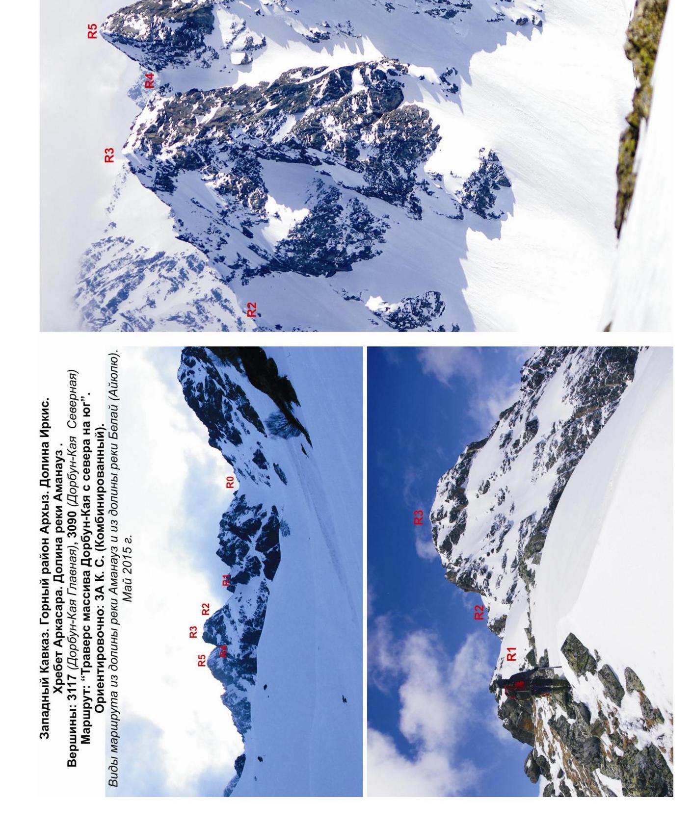
Western Caucasus. Mountain region Arkhyz. Irkis valley. Arkassara ridge. Amanaus river valley.
Peaks:
- 3117 (Dorbun-Kaya Main)
- 3090 (Dorbun-Kaya Northern)
Route: "Traverse of the Dorbun-Kaya massif from north to south". Approximately: 3A category. (Combined).
Photo of passage of second peak of traverse 3117 (Dorbun-Kaya Main). Photo on peaks 3090 (Dorbun-Kaya Main) and 3090 (Dorbun-Kaya Northern), 3117. May 2015.