Peak 3063 (Ayyulyu South). Route: via the eastern spur. Complexity category — 3A (combined). Team leader: A. Kuznetsov
Western Caucasus, Arkhyz, Irkis valley, Gabulu ridge, Ayyulyu tract
Section in KMGV — 2.1.
Report
On the first ascent of the climbing route to peak 3063 (Ayyulyu South) as part of the climbing competition: "Third stage of the cup of NP «Sauk-Pai North Travelers Club» — «Irkis-2015»" (class "First ascents") in May 2015.
Route: via the eastern spur. Complexity category — (approximately) 3A combined
Region: Karachay-Cherkess Republic. Mountain country: Western Caucasus. Valley: Irkis valley. Ridge: Gabulu, Ayyulyu tract. Peak: 3063 (Ayyulyu South). Route: via the eastern spur. Complexity level: 3A category (combined) (approximately). Prepared by: A. Kuznetsov, S. Zhuravlev. May, 2015.
Ayyulyu tract
The Ayyulyu tract is located in the upper reaches of the Belaya River (Ayyulyu) — a left-bank tributary of the Psysh River in the Irkis valley, on the eastern slope of the southern part of the northeastern spur of the Arkasar ridge (Gabulu ridge).
The Ayyulyu tract is a pronounced mountain horseshoe formed by the southeastern and eastern spurs of the Gabulu ridge. The nodal peaks and passes of the spurs do not have official names, but each has traditional names established in guidebooks and guide-books. The mountain horseshoe of the Ayyulyu tract (from left to right):
- 2989 (peak of the Caucasian Mountain Society)
- Tolyatti pass
- 3145 (Dorbun-Kaya)
- Dorbun pass
- 3213 (Dukka-Bashi)
- Oleniy pass
- 3063 (Ayyulyu South)
- Ayyulyu pass
- 3118 (Ayyulyu)
The ascent to the tract goes along a mountain trail along the Belaya River (Ayyulyu) to the lake, which is the source of the river. There is a shepherd's hut near the lake, used by shepherds in the summer. In the off-season, the hut can be used by climbers as temporary shelter in case of bad weather.
A characteristic feature of the peaks of the Ayyulyu tract is a long approach with a sharp gain in height and rocky towers made of dense rocks with small but technically complex sections. In the off-season, there may be an increased avalanche danger.
On the rocky ridges:
- an abundance of snow overhanging cornices.
Due to the fact that from the Irkis valley there is a large gain in height (a difference of more than 1500 m), ascents to the peaks of the Ayyulyu tract are conveniently done with an approach. The campsites in the Ayyulyu tract are convenient, provided with drinking water all year round.
As part of the climbing competition: "3rd stage of the cup of NP «Sauk-Pai-2015»" (Class "First ascents") three first ascents were made to the peaks of the Ayyulyu tract:
- First ascent of the route to the northeastern ridge of peak Tyungur;
- First ascent of the route to the western ridge of peak Ayyulyu;
- First ascent of the route to the southern ridge of peak Ayyulyu.
- peak 3118 (Ayyulyu) via the southern ridge — 1B category
- peak 3063 (Ayyulyu South) via the northern ridge — 2A (2B?) category
- peak 3063 (Ayyulyu South) via the eastern spur — 3A category
In the Ayyulyu tract, due to the high avalanche danger of the slopes, the mountain 3214 (Dukka-Bashi) — the highest peak of the tract — remained undeveloped. For the same reason, ascents to peaks 2989 (peak of the Caucasian Mountain Society) and 3145 (Dorbun-Kaya) were made from a neighboring valley — the valley of the Amanauz River.
Note: reports on the completed first ascents are attached.
Prospective climbing routes of the Ayyulyu tract:
- Route 1
- Route 2
- Route 3
- Route 4
- Route 5
- 3214 (Bolshaya Dukka) via the NE ridge (approximately 1B–2A).
- 3214 (Bolshaya Dukka) via the SE spur (approximately 1B–2A).
- 3087 (Bolshaya Dukka SE) via the N slope (approximately 1B–2A).
- 3087 (Bolshaya Dukka SE) via the NE ridge (approximately 1B–2A).
- 3117 (Dorbun-Kaya Main) via the SW ridge (approximately 2A–2B).
- 3117 (Dorbun-Kaya Main) via the N spur (approximately 3A–3B).
- 3117 (Dorbun-Kaya Main) via the NW ridge (approximately 2A–2B).
- 3117 (Dorbun-Kaya C) via the N spur (approximately 3B–4A).
- 2989 (peak of the Caucasian Mountain Society) via the NE ridge (approximately 2A–2B). Fragment of the map M: 1 cm — 500 m. Scheme of approaches to the Ayyulyu tract.
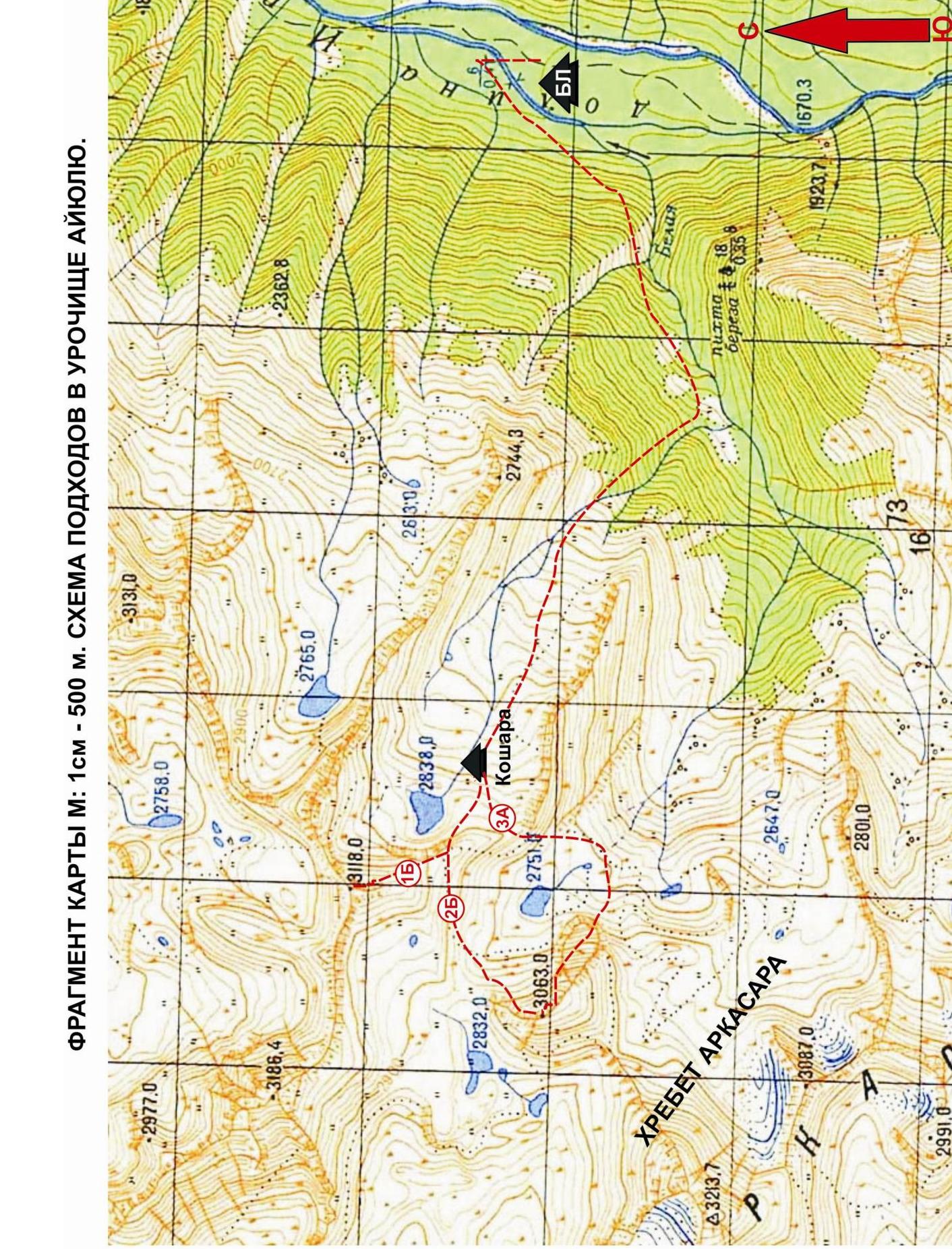 Western Caucasus. Arkhyz mountain region. Irkis valley. Northeastern spur of the Arkasar ridge (Gabulu ridge). Belaya River (Ayyulyu) valley. Ayyulyu tract. Overview of prospective climbing routes
Photo from the Ayyulyu tract. May 2015.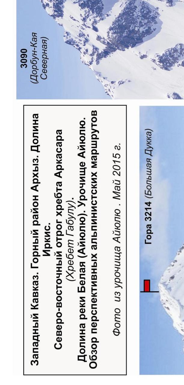
Passport
- Section number according to KMGV — 2010 — 2.1.
Western Caucasus, mountain region — Arkhyz, Irkis valley, northeastern spur of the Arkasar ridge (Gabulu ridge), Ayyulyu tract
- Name of the peak: 3063 (Ayyulyu South)
- Height: 3063 m
- Route: via the eastern spur
- Complexity category: 3A category
- Character of the route — combined.
- Height difference of the route:
From the base camp (confluence of the Belaya River (Ayyulyu) and the Psysh River) — 1300 m. From the shepherd's hut in the Ayyulyu tract — 750 m
- Length of the route:
Total length (from the hut) — 2100 m. Technical part (from R1) — 442 meters
- Length of sections of the highest category:
1 category — one section — 300 meters; 2 category — two sections — 40 meters; 3 category — three sections — 65 meters; 4 category — four sections — 37 meters; 5 category — 0 sections — 0 m; 6 category — 0 sections — 0 m.
-
Average steepness: total route — 55 degrees, technical part — 75 degrees
-
Number of pitons used:
Total pitons used on the route:
- rock pitons — 10
- chocks — 13
- stationary bolt pitons — 0
- ITO — 0
- removable bolt pitons — 0
Left on the route: total — 1; including bolt pitons — 0.
- Exit to the route — 6:30, May 6, 2015.
Reached the summit — 14:00, May 6, 2015. Return — 17:00, May 6, 2015.
- Team's walking hours: — 10 hours.
- Team leader: Alexander Kuznetsov (2nd sports category, Nevinnomyssk, Stavropol Krai).
Participants: Viktor Kuznetsov (2nd sports category, Nevinnomyssk, Stavropol Krai), Oleg Moskalchenko (2nd sports category, Nevinnomyssk, Stavropol Krai)
- Coach: Zhuravlev Sergey Vasilyevich (CMS, instructor-methodologist 1st category).
Analogous routes:
- 3226 — 3A category (South slope and 3rd group) (Arkhyz)
- MNR (Southwest) from the south via the couloir. 3rd group 3A category (Adylsu)
- Nikolaev peak via the North wall — 3A category (Cey)
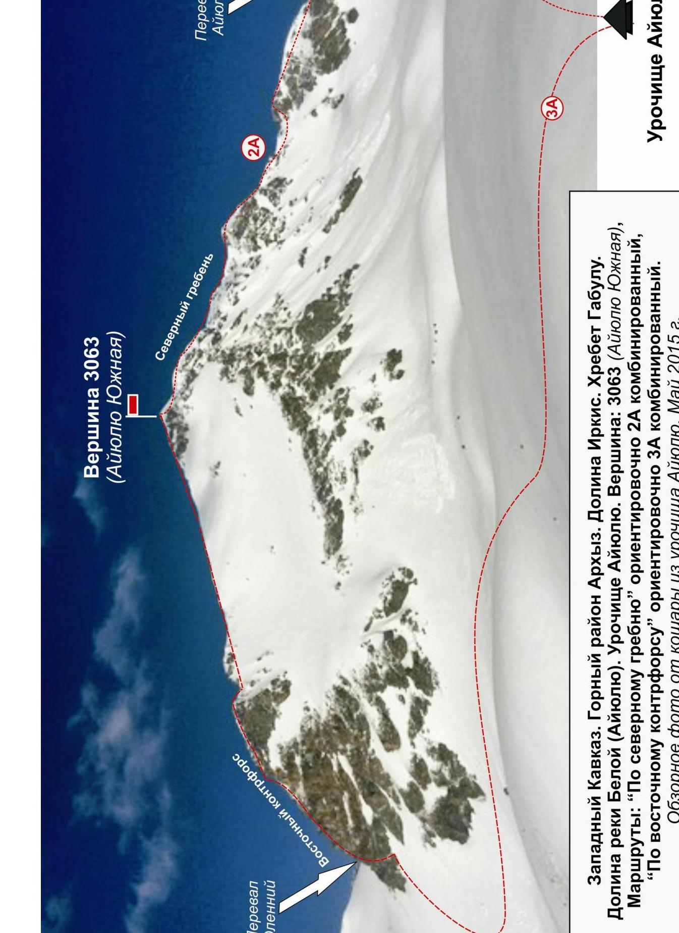
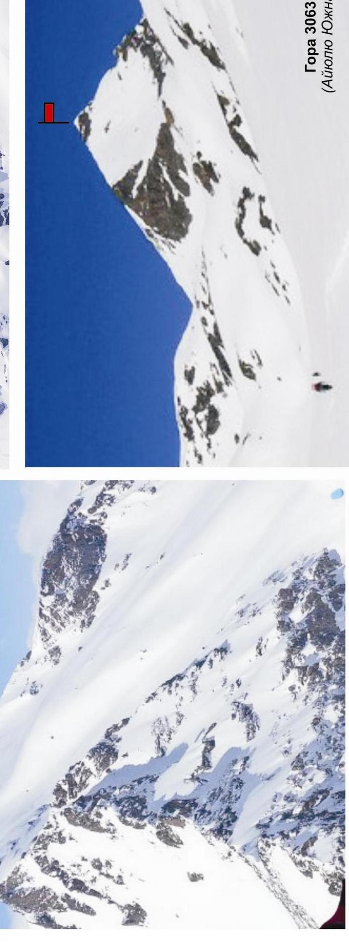
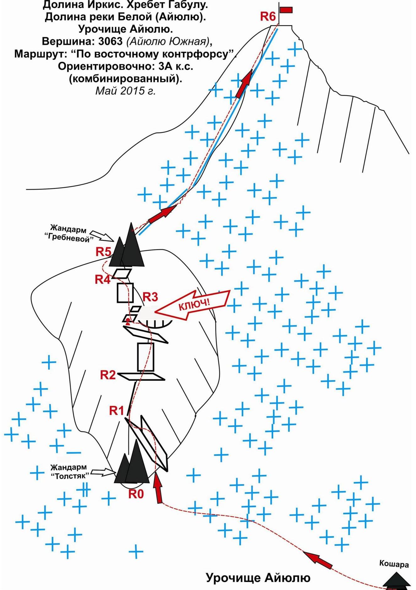
Western Caucasus. Arkhyz mountain region. Irkis valley. Gabulu ridge. Belaya River (Ayyulyu) valley. Ayyulyu tract.
Peak: 3063 (Ayyulyu South)
Routes:
- via the northern ridge — approximately 2A combined
- via the eastern spur — approximately 3A combined
Overview photo from the hut in the Ayyulyu tract. May 2015.
Description of the peak
Peak 3063 (Ayyulyu South) is located in the southern part of the northeastern spur of the Arkasar ridge (Gabulu ridge), in the upper reaches of the Belaya River (Ayyulyu) valley, in the Ayyulyu tract between the Ayyulyu pass (north) and Oleniy pass (south).
The peak is marked on the General Staff map with a height mark. The name of the peak Ayyulyu South (as well as the passes) is unofficial, given for identification.
Peak 3063 (Ayyulyu South) in the Ayyulyu tract is easily identifiable due to the pronounced depressions (passes).
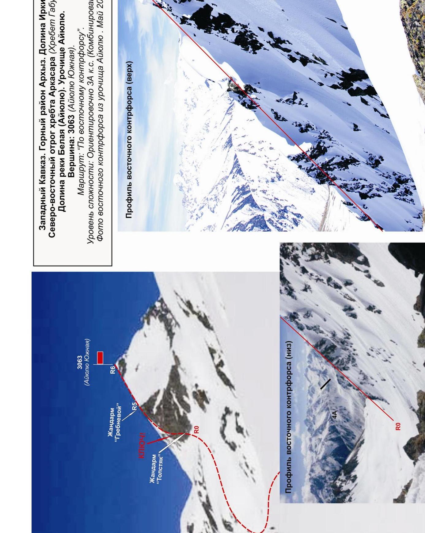
Description of the route
Route: "Via the eastern spur" — a typical educational and sports combined route of IV category, with a full range of natural obstacles corresponding to routes of this level. The eastern spur is the only pronounced rocky spur to the east of the peak.
Equipment
For the ascent, a sports team of 4 people will need the following special equipment:
-
Personal — standard, crampons, ice axe
-
Group:
- main rope 10 mm — 2 × 50 m
- rock hammer — 2 pcs
- rock pitons — 10 pcs
- ice axe — 1 pc
- chocks — 12 pcs
- friends — 6 pcs
- ice screws — 0 pcs
- quickdraws — 16 pcs
- slings — 10 pcs
Approach
From the base camp, located near the confluence of the Belaya River (Ayyulyu) and the Psysh River, ascend along the left (orographic) bank of the Belaya River (Ayyulyu). Follow the path to the right to the shepherd's hut in the Ayyulyu tract. The approach takes 3–4 hours.
The ascent is made from the hut. The approach to the base of the eastern spur from the hut takes about an hour. Organize a team at the base of the spur.
Technical part
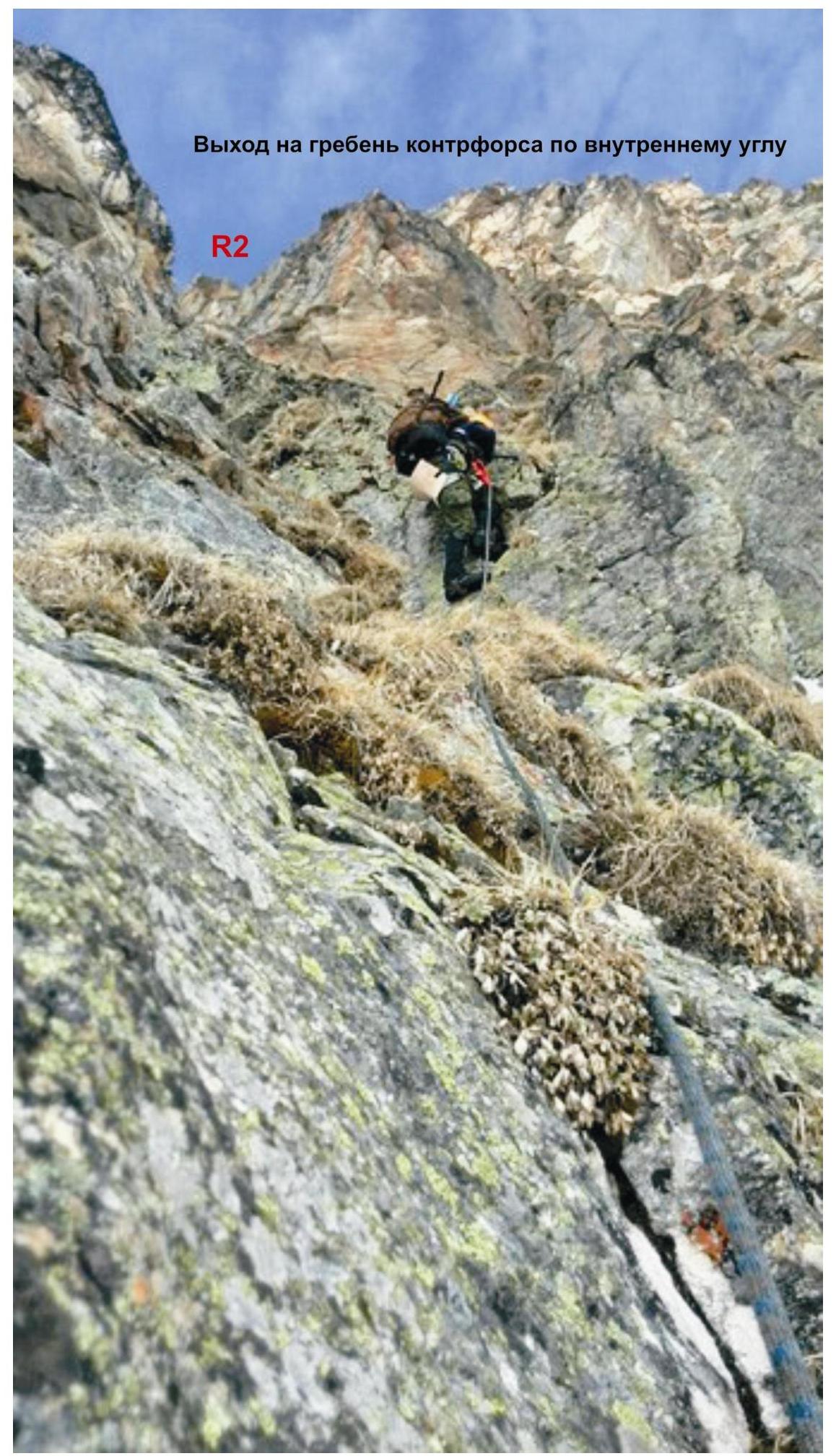
The base of the spur is marked by a large gendarme in the ridge — "Tolstyak" gendarme. This gendarme is bypassed on the right by an internal angle leading to the rocky ridge of the spur. The ridge is wide, heavily destroyed, and leads to the key wall.
The KEY section of the route: a technically complex wall-monolith, complex in orientation, with a traverse under an overhanging section. The key is passed in three stages.
- First, ascend the rocky monolithic wall (complicated climbing with minimal natural relief for insurance) to an inclined rocky ledge.
- Then traverse along the inclined rocky ledge to the left. During the traverse, pass the most complex section — the "Puzo" cornice. The section is small but technically and psychologically complex. A hook is left at the beginning of the passage.
- After passing the traverse, ascend a series of slabs under the wall leading to the ridge of the spur.
The wall is technically complex but has abundant micro-relief for insurance on chocks. It leads under the pronounced gendarme "Grebnevoy" at the junction of the spur and the summit dome. The "Grebnevoy" gendarme is bypassed on the left via simple rocks. In the upper part, the rocks turn into a scree slope of the summit dome. Then ascend along a prolonged snowy ridge to the summit.
The summit 3063 (Ayyulyu South) is pronounced. The cairn is located above the official height mark (on a rise on the slope to the south, height 3078 according to GPS).
Descent:
- down the northern slope into the northern cirque;
- then traverse the snowy cirque at a relatively large distance (possibility of rockfall and avalanches) towards the Ayyulyu pass;
- the height difference is small — 100–150 m;
- then ascend to the Ayyulyu pass and descend to the hut in the Ayyulyu tract.
Recommendations for instructors
Due to the accessibility of the route in terms of orientation, it can be recommended for both educational and sports teams (SP-1, 2) and for independent sports groups of разрядникs making руководства or training ascents.
Time spent on the route for an educational and sports team of разрядникs of average preparation level (SP-2) — 10–12 hours
Western Caucasus. Arkhyz mountain region. 3063 (Ayyulyu South)
- Irkis valley
- Gabulu ridge
- Belaya River (Ayyulyu) valley
- Ayyulyu tract
- Peak: 3063 (Ayyulyu South)
- Route: "Via the eastern spur"
- Approximately: 3A category (combined)
- May 2015
Western Caucasus. Arkhyz mountain region. Irkis valley. Northeastern spur of the Arkasar ridge (Gabulu ridge). Ayyulyu tract. Peak 3063 (Ayyulyu South). Route: via the eastern spur. Complexity category: 3A category combined (approximately)
Table of natural obstacles on the route
| APPROACH | From the hut in the Ayyulyu tract, turn left towards the Olenye pass (60 min) to the base of the pronounced rocky spur separating the Ayyulyu tract into two cirques | |||
|---|---|---|---|---|
| R0 | Place of organization of the связок: under the internal angle on the right side (along the way) of the контрфорса, separating the last жандарм from the гребня | |||
| Characteristics of sections | length | steepness | Complexity level | Notes |
| R0–R1. Exit to the гребень контрфорса via the rocky внутренний угол. 1. Lower part of the внутренний угол 2. Upper part of the внутренний угол | 20 10 | 75 90 | 3+ 4-, 4+ | Used: крючьев/закладок: 3 4 Pitons and chocks not left |
| R1–R2. Wide разрушенный гребень контрфорса. Approach to the key. | 30 | 45 | 2- | Used: крючьев/закладок: 0 0 Pitons and chocks not left |
| :--: | :--: | :--: | :--: | :--: |
| R2–R3. Passage of the key. KEY — steep, smooth rock wall (monolith), complex in orientation. Passed in four stages: 1. Approach to the косую полку under the нависание. 2. Traverse left along the косую полку under the нависанием «Пузо». 3. Ascent along the стена 4. Exit to the гребневую полку via the плиты. On the полке is a control тур. | 10 7 10 30 | 90 95 80 30 | 4+ 4+ 4+ 3-. To the top, it simplifies to 1+ к. с. | Used: крючьев/закладок: 5 5. Left крючьев, закладок: 1 / 0. Stations — крючьевые. Recommended for narrow трещин in the monolith — flat, horizontal and anchor крючья. At the beginning of the traverse «Пуzo» is left an anchor крюк. |
| R3–R4. Passage of the стенки (left of the control тура). | 15 | 55 | 3-, 3+ | Used: крючьев/закладок: 2 2. Pitons and chocks not left |
| R4–R5. Junction of the контрфорса with the вершинному куполом. Bypass of the жандарма «Гребневой» (left along the way). | 10 | 50 | 2- | Used: крючьев/закладок: 0 2. Pitons and chocks not left |
| R5–R6. Exit to the вершина. Scree заснеженными склонами | 300 | 12 | 1, н \ к | Used: крючьев/закладок: 0 / 0. Pitons and chocks not left |
| R6 — вершина 3063 m | Summit — pronounced scree купол, тур in the left upper part. | |||
| :-- | :-- | |||
| DESCENT | Down the northern slope to the snowy fields of the northern цирка. Then along the плато of the northern цирка to the Ayyulyu pass. Ascent to the Ayyulyu pass and descent from the pass to the hut (1.5 hours). |
Total:
Length of the route
(without approach) — 442 m
Average steepness:
total route — 55°, technical part — 75°
Technical sections:
- 1 category — one section — 300 m
- 2 category — two sections — 40 m
- 3 category — three sections — 65 m
- 4 category — four sections — 37 m
Used (left):
Pitons — 10 (1), Chocks — 13 (0)
Western Caucasus. Arkhyz mountain region. Irkis valley. Northeastern spur of the Arkasar ridge (Gabulu ridge). Belaya River (Ayyulyu) valley. Ayyulyu tract. Peak: 3063 m (Ayyulyu South). Route: "Via the eastern spur". Complexity level: approximately 3A category (Combined)
Photo of the eastern spur from the Ayyulyu tract: May 2015.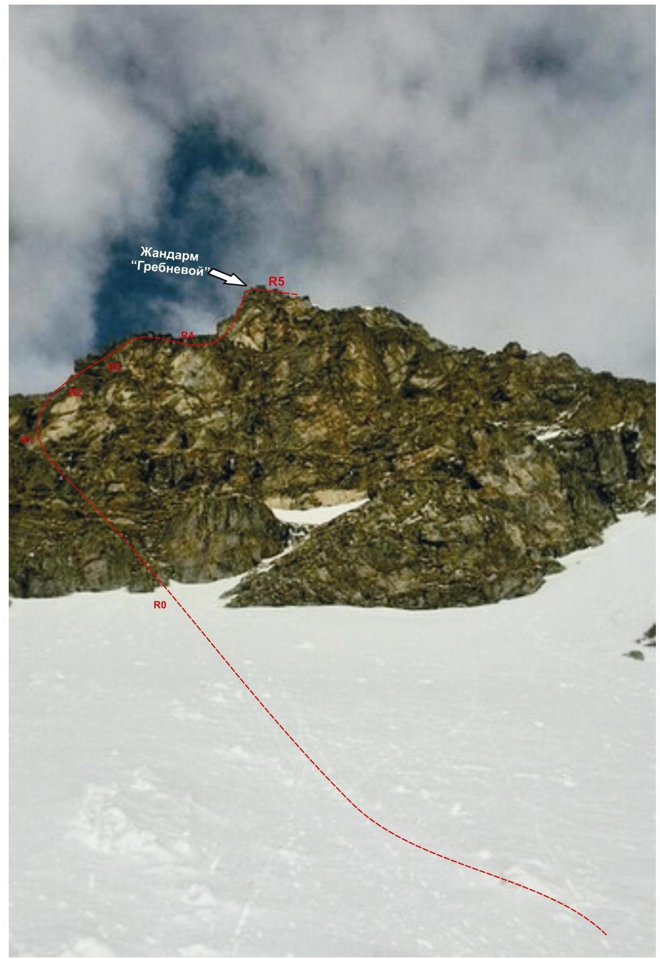
Exit to the гребень контрфорса via the внутренний угол. Key section of the route.
Tраверс of the cornice
«Пузо»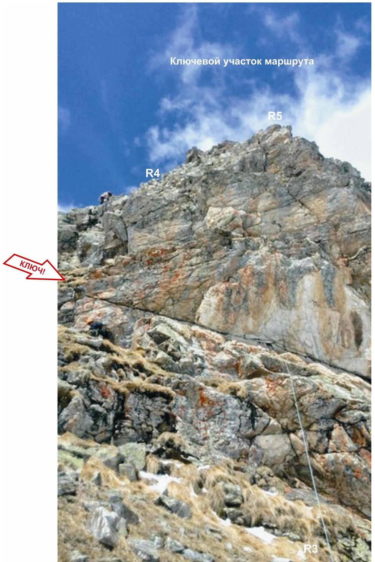
Key section of the route.